

Introduction
Marine-terminating glaciers are a major conduit of mass loss from the ice-sheet system (Reference JoughinJoughin and others, 2008a; Reference Pfeffer, Harper and O’NeelPfeffer and others, 2008). Changes at the fronts of marine-terminating outlet glaciers effect flow speed variations by modulating the balance of driving and resistive stresses (Reference Meier and PostMeier and Post, 1987; Reference JoughinJoughin and others, 2008a). The Greenland ice sheet annual mass deficit has grown substantially during the past two decades (Reference Rignot, Box, Burgess and HannaRignot and others, 2008). Abrupt glacier flow acceleration has been attributed to loss of bed traction from thinning and retreat of the calving fronts (Reference KrabillKrabill and others, 2004; Reference ThomasThomas, 2004; Reference Luckman, Murray, de Lange and HannaLuckman and others, 2006; Reference Howat, Joughin and ScambosHowat and others, 2007; Reference Joughin, Das, King, Smith, Howat and MoonJoughin and others, 2008b; Reference Nick, Vieli, Howat and JoughinNick and others, 2009). Rapid thinning prior to retreat has been linked with enhanced submarine melting due to the incursion of warm ocean currents (Reference Holland, Thomas, de Young, Ribergaard and LyberthHolland and others, 2008). Multi-year retreats may be triggered in single anomalous years (Reference Howat, Box, Ahn, Herrington and McFaddenHowat and others, 2010) followed by a multi-year dynamic response that includes thinning-induced inland grounding-line migration and upstream steepening of the surface slope, increasing driving stresses (Reference Howat, Joughin, Tulaczyk and GogineniHowat and others, 2005).
While submarine melting can occur at a much higher rate than at the surface–atmosphere interface (Reference Motyka, Hunter, Echelmeyer and ConnorMotyka and others, 2003; Reference Rignot, Koppes and VelicognaRignot and others, 2010), it is not necessarily the only significant factor influencing glacier front stability. Stability is also influenced by the winter consolidation of calf ice and landfast sea ice, leading to post-melt-season advance (Reference Amundson, Fahnestock, Truffer, Brown, Lüthi and MotykaAmundson and others, 2010; Reference Howat, Box, Ahn, Herrington and McFaddenHowat and others, 2010). The advanced area is typically lost through rapid calving and retreat at the onset of the melt season. At Greenland’s most productive glacier, Jakobshavn glacier (also known as Jakobshavn Isbræ or Sermeq Kujatdleq) (Reference Weidick and BennikeWeidick and Bennike, 2007), the interannual cycle in calving-front position exceeded 4 km (Reference Sohn, Jezek and van der VeenSohn and others, 1998). Reference Reeh, Thomsen, Higgins and WeidickReeh and others (2001) and Reference JoughinJoughin and others (2008a) earlier evaluated the importance of glacier front ice consolidation to glacier front stability. Seasonal retreat and advance causes an annual velocity cycle for some western Greenland marine-terminating glaciers (Reference Joughin, Das, King, Smith, Howat and MoonJoughin and others, 2008b). Several other marine-terminating glaciers in Greenland exhibit a smaller seasonal advance/retreat than Jakobshavn Isbræ, usually <1 km in the case of glaciers near the settlement of Uummannaq, West Greenland (Reference Howat, Box, Ahn, Herrington and McFaddenHowat and others, 2010). Inland ice-sheet flow accelerates more than 100% during active surface melt (Reference Zwally, Abdalati, Herring, Larson, Saba and SteffenZwally and others, 2002; Reference Van de WalVan de Wal and others, 2008; Reference Shepherd, Hubbard, Nienow, King, McMillan and JoughinShepherd and others, 2009). Greenland melt rates have increased substantially since a multi-decadal minimum in the mid-1980s (Reference BoxBox and others, 2006, Reference Box, Yang, Bromwich and Bai2009). Surface melting in the Arctic is projected to increase, driven not only by increasing atmospheric heat content, but by polar amplification of warming resulting from ice-albedo feedback (Reference SolomonSolomon and others, 2007). Ocean heat content increases have been observed in Baffin Bay during the period 1916–2003 (Reference Zweng and MünchowZweng and Münchow, 2006) and elsewhere throughout the global oceans in past decades (Reference Levitus, Antonov, Boyer, Locarnini, Garcia and MishonovLevitus and others, 2009). Thus, in recognition of multiple forcings, the most likely scenario is that the ice-sheet mass budget deficit will continue to grow, contributing to global sea-level rise.
Reference Moon and JoughinMoon and Joughin (2008) surveyed area changes at the 182 Greenland ice sheet outlet glaciers of at least 2 kmwidth. The majority of these glaciers are marine-terminating and six are noted to have terminal ice shelves, namely Petermann, ZachariÌ, NioghalvfjerdsbrÌ/79, Ostenfeld, Jakobshavn and Ryder. They found that the 2000–06 period was characterized by significant area losses while the earlier period 1992–2000 exhibited a more stable pattern. All of the glaciers advancing in 1992–2000 began retreating during 2000–06. Reference Moon and JoughinMoon and Joughin (2008) associate the area losses with an increase in summer near-surface air temperatures. They also point to an emerging recognition of submarine melting (Reference Rignot and JacobsRignot and Jacobs, 2002; Reference ThomasThomas, 2004) in potentially destabilizing glaciers. Further, they implicate a potential role of decreasing sea-ice extent or increased hydrofracture and calving from meltwater on the surface to explain the increase in retreat.
Reference Howat and EddyHowat and Eddy (2011) measured area changes at 210 marine Greenland glaciers in Landsat imagery spanning the early 1970s to 2010. They found that the magnitude and extent of retreat increased in the early 1990s, coincident with the onset of warming following several decades of cooling and glacier stability. The results suggest that retreat over the decade 2000–10 is the most extensive in Greenland in the past half-century and possibly since the Little Ice Age (LIA). That study, however, did not resolve sub-decadal variability in front position. Reference Moon and JoughinMoon and Joughin (2008) note that there was a significant decrease in southeast Greenland retreat in the mid-2000s. Yet, it remains unclear whether glacier retreat has accelerated during the decade or whether much of the retreat occurred during a single short-lived episode early in the decade and has largely subsided.
In this study, the area changes at the 39 widest marine-terminating glacier outlets to the Greenland ice sheet are measured each year in the period 2000–10 using end-of-melt-season Moderate Resolution Imaging Spectroradiometer (MODIS) imagery. Cumulative changes and trends are evaluated on individual glacier, regional and whole-island scales. In the analysis, some distinction is made between glaciers with known ice shelves and those without.
Data and Methods
Optical imagery
NASA MODIS 0.25km resolution band 1 (620–670 nm) and band 2 (841–876 nm) MOD02 product imagery from the Terra satellite beginning in the year 2000 are used in this study to classify the position of glacier fronts. The MOD03 geolocation product is incorporated via the MODIS Swath-to-Grid Toolbox (MS2GT) (http://nsidc.org/data/modis/ms2gt/) to project the data onto a 0.25km azimuthal Equal-Area Scalable Earth Grid (EASE-Grid). In recognition of a potential annual cycle in front position (discussed above), we choose images from the end of the melt season. These occupy a 43 day period, 17 August to 29 September. MODIS data have the advantage of much more frequent (~daily) coverage than higher-resolution sensors such as Landsat or ASTER.
Area change is classified manually using spatial patterns in reflectance and texture in polygons relative to an arbitrary line beyond the glacier front and constrained by the fjord sides, similar to the approach of Reference Moon and JoughinMoon and Joughin (2008). Consecutive annual polygons are differenced to quantify interannual area change. This area classification was repeated three or five times on the same image pairs to evaluate uncertainty. In the >400 repeat samples, we find that the interannual area changes exceed two standard deviations of the repeat samples (1.0km2) in 63% of cases. The absolute accuracy of the classification depends on decisions by the person who distinguishes between glacier ice, calf ice, sea ice, clouds, sea and land. In ideal cases when there is little or no sea ice, the accuracy approaches the measurement precision. In marginal cases when images are blurry, have cloud contamination, shadows from land, and a less distinct calving front owing to increasing sea-ice concentration, the absolute accuracy is low (<10km2). A glacier area increase, an advance, is given a positive sign. Conversely, negative values here represent glacier retreat. Effective glacier length changes were determined by dividing the area change by the glacier width measured at the year 2000 front.
All glaciers in the survey are marine-terminating. Our annual survey contains 30% (421 km) of total glacier width (1417 km) or 39 of the 261 (15%) marine-terminating glaciers of at least 1 kmwidth. The relatively small fraction of the total count results from the fact that we select the widest glaciers where relatively large area changes are resolvable; essentially where the signal-to-noise ratio is highest and where calving rates are greatest (Reference Weidick and BennikeWeidick and Bennike, 2007). We find no correlation (R = 0.05) between glacier width and the effective glacier length change (area change divided by width). We may therefore conclude that we do not incur a sampling bias by preferentially measuring the widest glaciers.
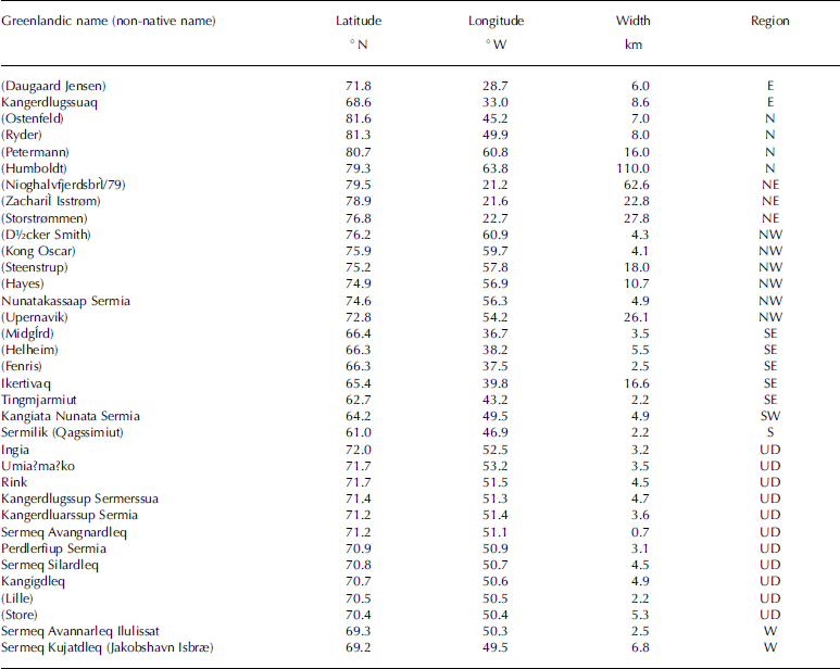
Like Reference Moon and JoughinMoon and Joughin (2008), we treat the six glaciers with extensive ice shelves (named above) separately from the other glaciers because the buttressing effects of ice shelves (e.g. Reference De Angelis and SkvarcaDe Angelis and Skvarca, 2003) seem to offer distinct situations. The name, position, width and geographic region of the glaciers surveyed are listed in Table 1. Figure 1 illustrates the glacier positions, names and regions chosen for discussion.
Greenland glaciers surveyed in this study in years 2000–10. Regions are shown in Figure 1 (UD: Uummannaq district)
Greenland location map showing the surveyed glaciers. Regional divisions are bracketed by dashed lines.

Area Changes
Individual and regional glacier changes
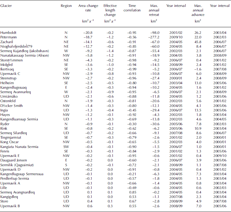
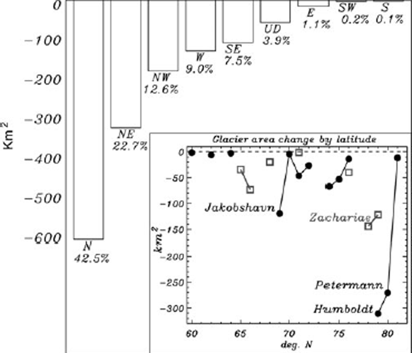
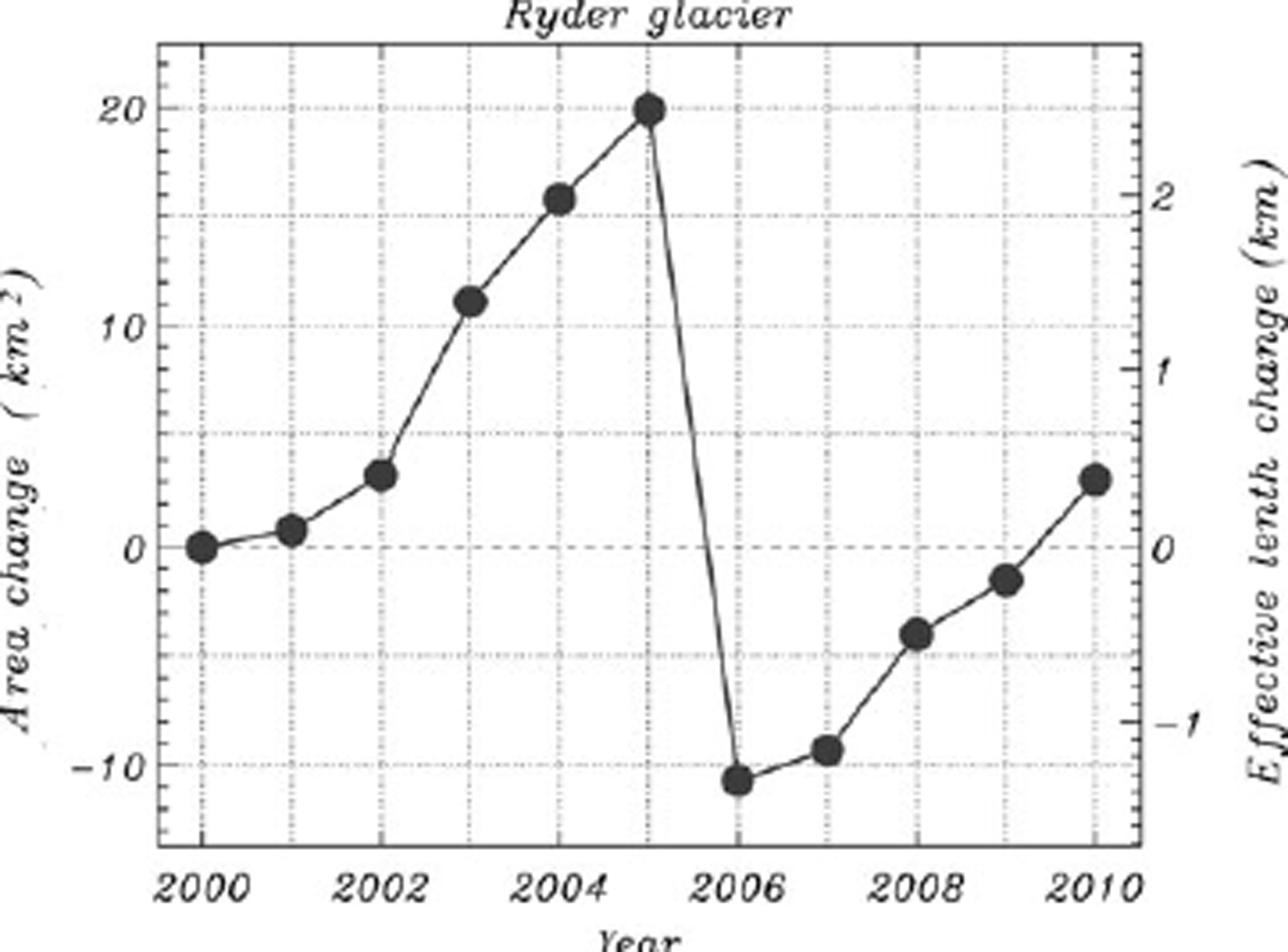
The largest cumulative area changes occur in northern Greenland, with more than three-quarters of the change north of 72˚ N (Fig. 2). Area change (loss) is greatest at the glaciers that have floating tongues: ZachariÌ Isstrøm, Jakobshavn, Petermann and Humboldt (Table 2; Fig. 2 inset). Cumulative area change at several glaciers through time is well represented by linear regression as indicated by correlation values in Table 2. Other glaciers, like Ryder glacier, exhibit a pattern of multi-annual advance that may be characterized by high linear fit correlation values. However, this advance between 2000 and 2005 was punctuated by a single major calving in 2006 and was followed again by advance each year during 2007–10 (Fig. 3).
Greenland glacier area and length change statistics 2000–10 sorted by the decadal area change rate. Regions are shown in Figure 1
Area change totals for Greenland regions during the period 2000–10 and their percent of the total. The inset illustrates total area change by 1˚ latitude bins. West Greenland is represented by black and East Greenland by gray. Glaciers with the largest area changes are indicated.
Cumulative net area change at Ryder glacier for 2000–10.
North
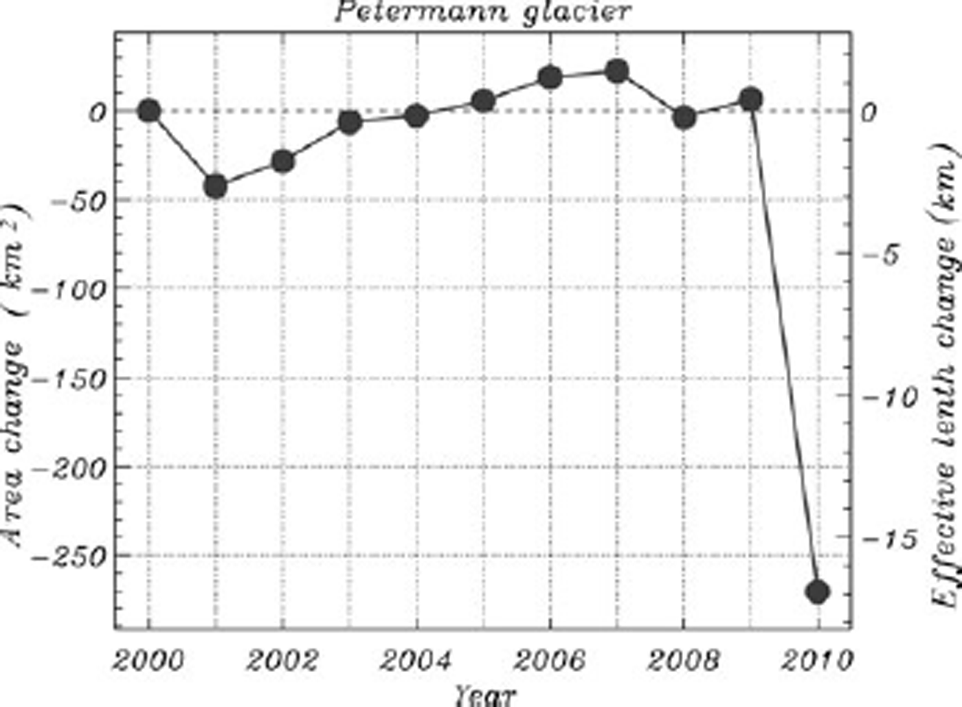
The largest single annual glacier area change evident in our survey is the loss at Petermann glacier between 3 and 5 August 2010. The glacier front lost 277 km2, effectively retreating 17km between end-of-summer periods in 2009 and 2010 (Fig. 4). The 2010 front position is retreated compared with available observations from 1962, 1963 and 1992 (Reference Zhou and JezekZhou and Jezek, 2002), 1953, 1959 and 1978 (Higgins, 1990), and 1922 (Reference KochKoch, 1926, Reference Koch1928). A large rift upstream of the 2010 terminus suggests that the next major area loss could be ~150km2.
Cumulative net area change at Petermann glacier for 2000–10.
The largest net area change for a single glacier during this survey period is the 311 km2 loss at Humboldt Glacier. Practically all of the area changes have occurred in an embayment ~12km south of its northern limit where grounding-line retreat has been detected (Reference Rignot, Gogineni, Joughin and KrabillRignot and others, 2001). The second largest single annual area loss in our survey (98.0km2) occurred at northern Humboldt in the 2001/02 end-of-summer interval. Comparing the 2000–10 decade of MODIS-derived calving-front positions with those from other sensors in Reference Rignot, Gogineni, Joughin and KrabillRignot and others (2001), northern Humboldt has been in retreat since at least the 1990s. Landsat imagery (courtesy of I. Howat of the Byrd Polar Research Center; http://glovis.usgs.gov) from 1975, 1999 and 2008 indicates an acceleration of area loss since 1975 and an ice stream flowing towards the present-day embayment.
Northeast
ZachariÌ Isstr½m terminates into an embayment packed with multi-year calf ice. Reference KochKoch (1945) first referred to this ice mixture by the Inuit term sikussak. The term is used in East Greenland meaning ’ice-like ocean ice’ and referring specifically to very old fast ice that has attained extreme thickness through age, low ocean heat flux (e.g. through being in a fjord) and/or high precipitation (again, for example, in a fjord) (P. Wadhams, cryolist communication). The ZachariÌ front area changes were small in the first 2 years of this survey, after which an area loss exceeding 14 km2 a–1 ensued. Yet, uncertainty in this study is exemplified by the result of a large 2006/07 advance (48km2; Table 2) that may not be real
At NioghalvfjerdsbrÌ, also called the 79˚ N glacier, an overall retreat rate of 12.7 km2 a–1 is evident. Although small for north Greenland, this change outranks the majority of the other glacier trends in our survey (Table 2).
Storstrømmen, considered a surge-type glacier (Reference Reeh, Bøggild and OerterReeh and others, 1994; Reference Rignot, Gogineni, Joughin and KrabillRignot and others, 2001), exhibits a smaller area loss rate of 4.3 km2 a–1 (Table 2).
East
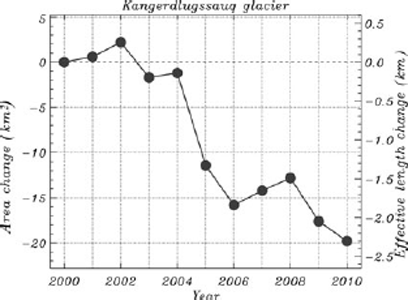
East Greenland glacier area changes are dominated by those at Kangerdlugssuaq (Fig. 5), one of the fastest-flowing and most productive of all glaciers in Greenland (Reference Rignot and KanagaratnamRignot and Kanagaratnam, 2006). The largest annual area loss at Kangerdlugssuaq was 10.2 km2 between the 2003 and 2004 end-of-summer periods. Area losses at this glacier add to a decadal retreat that is well represented by a linear fit (R = –0.94) with a retreat rate of 2.4 kma–1 (Table 2). Reference ThomasThomas and others (2000) find substantial thinning at this glacier during the 1990s and <1 km retreat between 1966 and 1999.
Cumulative net area change at Kangerdlugssuaq glacier for 2002–10.
Daugaard Jensen glacier has undergone multi-annual advances and retreats of <0.7 km, with a cumulative area loss of 2.5 km2.
Southeast
The clearest pattern of ice area loss for southeast Greenland glaciers during the survey period is at MidgÍrd glacier, where an average frontal retreat of 1.0 kma–1 is evident (Table 2). Other changes in southeast Greenland glacier length are in the range –0.1 to –0.5kma–1. Collectively, this region has accelerated in flow (Reference KrabillKrabill and others, 2004; Reference Luckman, Murray, de Lange and HannaLuckman and others, 2006), synchronous with elevated air and oceanic temperatures (Reference Howat, Joughin, Fahnestock, Smith and ScambosHowat and others, 2008). Reference StraneoStraneo and others (2010) link the acceleration trigger with the delivery of warm waters into glacier fjords by wind-driven ocean currents.
South and southwest
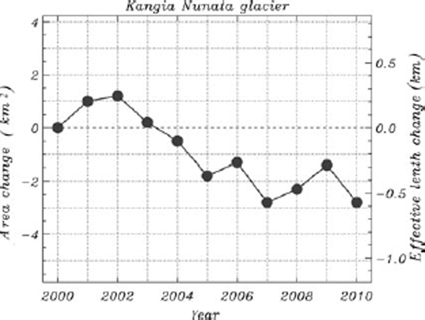
The relatively few marine-terminating glaciers in this region exhibit relatively small area fluctuations. Kangiata Nunata Sermia (sermia means glacier or ice field in Greenlandic) retreated on average 0.1 km a–1 in the period 2000–10 (Table 2; Fig. 6). Note the relatively small area/length changes compared with other glaciers in this study. Sermilik (Qagssimiut) advanced 1.1 km2 in the 2007/08 period followed by a 2.1 km2 retreat in the 2008/09 period. The two surveyed glacier fronts from this region exhibit a net area loss of 5 km2 between 2000 and 2010.
Cumulative net area change at Kangia Nunata glacier for 2000–10.
West-central
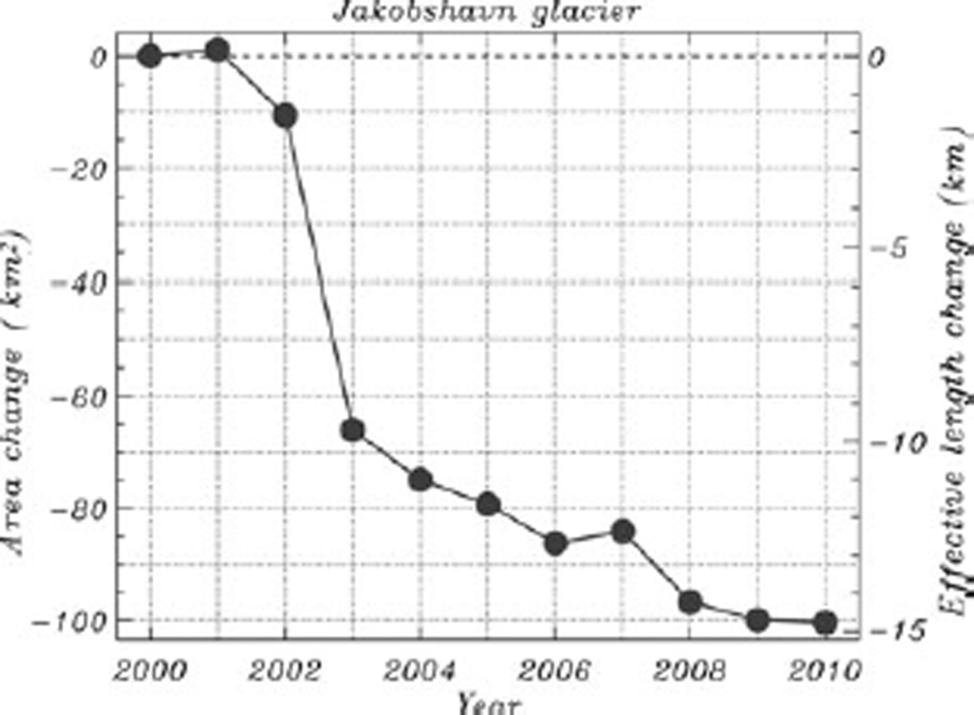
Area changes in west-central Greenland are dominated by Sermeq Kujatdleq (Jakobshavn Isbræ) (Table 2; Fig. 7). A peak annual area loss of 55 km2 occurred between 2002 and 2003 as the ice shelf of the glacier disintegrated. Prior to this the glacier front was relatively stable for about four decades (Reference Weidick and BennikeWeidick and Bennike, 2007). The 2003 area loss is recognized as resulting in a loss of flow resistance during a period of thinning (Reference ThomasThomas, 2004) and acceleration (Reference Joughin, Abdalati and FahnestockJoughin and others, 2004). Retreat has continued since the loss of the ice shelf at a lesser rate of 0.6 kma–1 in the 2005–10 period. Between 2000 and 2010, we find a 100 km2 cumulative area loss and an effective glacier front retreat sum of 14.8 km. Since the LIA maximum extent in 1850 (Reference Weidick and BennikeWeidick and Bennike, 2007), Sermeq Kujatdleq has retreated >50 km. Prior to this period, there is evidence of retreat upstream of the LIA ice front during the mid-Holocene thermal maximum (e.g. Reference Weidick and BennikeWeidick and Bennike, 2007).
Cumulative net area change at Jakobshavn glacier for 2000–10.
Area losses at Sermeq Avannarleq are well represented by a linear fit (Table 2) and peaked at 6.5 km2 loss in the 2006/ 07 interval.
Uummannaq district
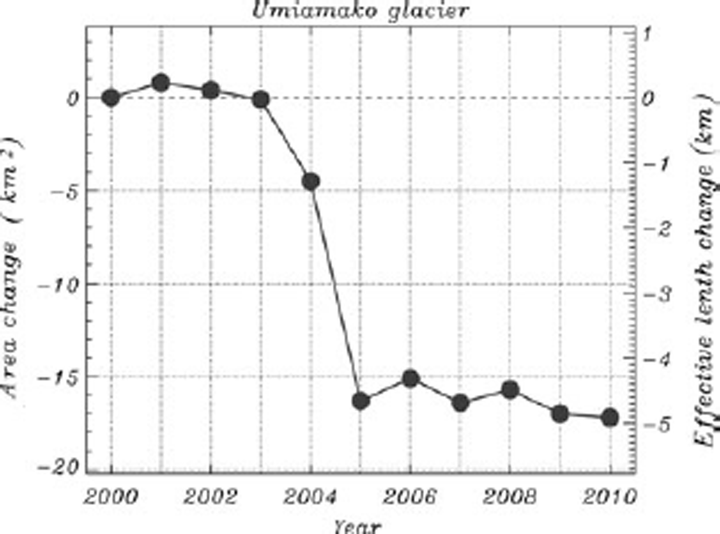
The greatest glacier area changes in the vicinity of the Uummannaq settlement have been at Umia?ma?ko glacier where an area loss of 15 km2 occurred in 2004 and 2005 (Fig. 8). Umia?ma?ko advanced slightly by 1.2 km2 between 2005 and 2006 and continued to retreat, though at a much slower rate, through 2010 (Table 2). Rink and Store glaciers are the next most productive West Greenland calf ice producers (Reference Rignot and KanagaratnamRignot and Kanagaratnam, 2006; Reference Weidick and BennikeWeidick and Bennike, 2007). Store glacier’s front position was 2.5 km advanced in 2010 from its 2000 position, with no apparent trend during this survey period. Rink glacier, like Store glacier, has a relatively stable front position, with an insignificant front position change in the 2000–10 period. The 11 surveyed Uummannaq district glaciers exhibit a net area loss of 51 km2 between 2000 and 2010.
Cumulative net area change at Umia?ma?ko Glacier for 2000–10.
Northwest
Early last century, five ice-sheet outlet glaciers east of Upernavik settlement flowed together and produced a ~100km2 ice shelf that disintegrated in the 1931–49 period (Reference WeidickWeidick, 1958). Today, the five now separated outlets, here named Upernavik A–E (see http://bprc.osu.edu/MODIS/?p=40) are discussed individually. Outlet C has changed most, losing 23.1 km2 since 2000. This outlet accounts for 78% of the total net cumulative loss for the five glaciers. The retreat rate for C is 0.8 kma–1, R = –0.93). Upernavik outlets A, B, D and E have average length changes in the +0.3 to –0.1km a–1 range.
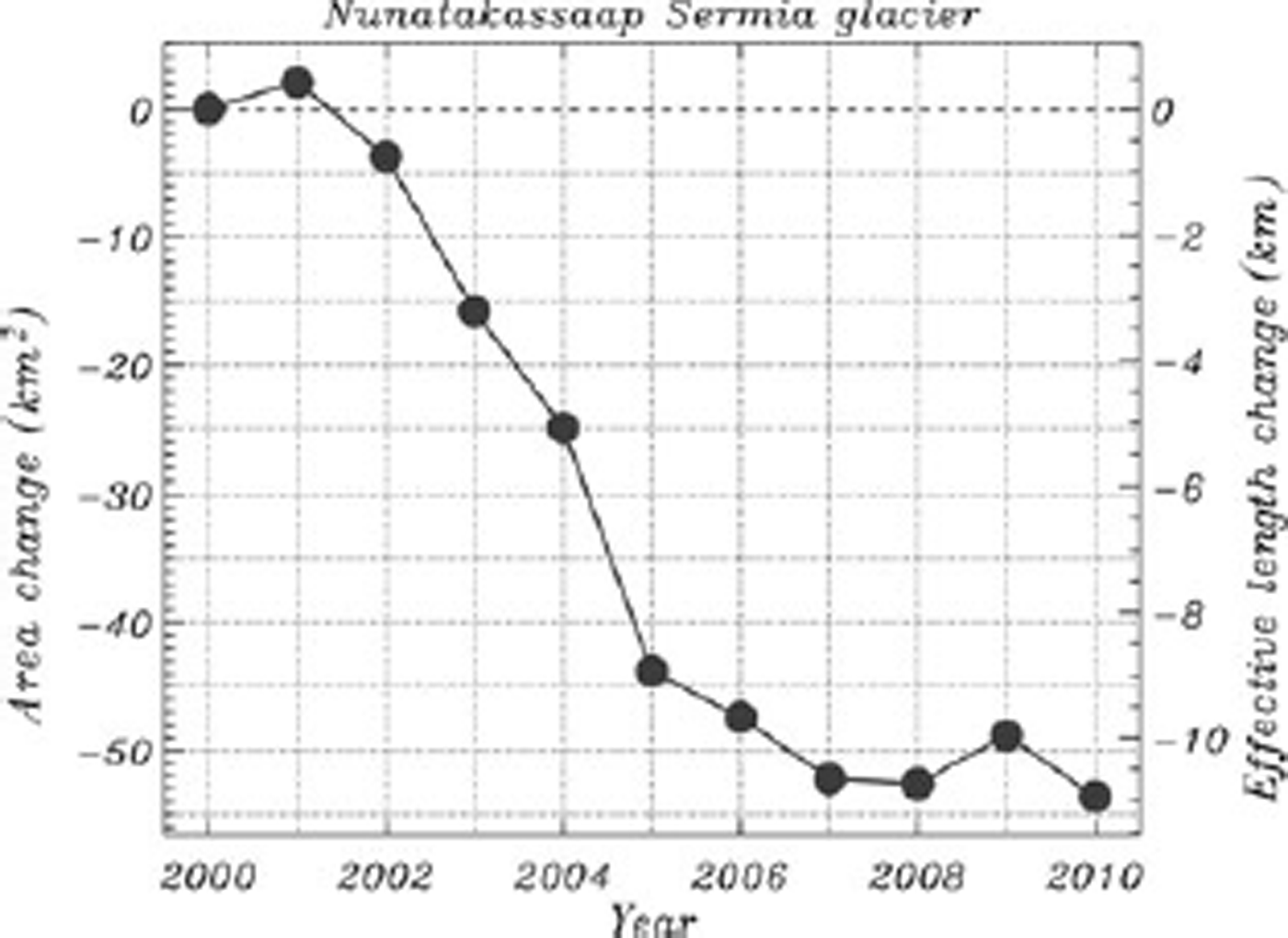
The time-averaged glacier area changes in northwest Greenland are highest at Nunatakassaap Sermia (Fig. 9), referred to elsewhere (e.g. Reference Joughin, Smith, Howat, Scambos and MoonJoughin and others, 2010; Reference Howat and EddyHowat and Eddy, 2011) using the name of the bay in front of the glacier, i.e. Alison, with an annual effective area loss rate of 5.8 km2 a–1 (Table 2) driven by a multi-year retreat spanning 2002–08 (see also Reference Moon and JoughinMoon and Joughin, 2008).
Cumulative net area change at Nunatakassaap glacier for 2000–10.
Area Change Analysis
Stability of glaciers and ice shelves
Considering all glaciers (including those with ice shelves) with interannual area changes of <1.0km2 to be ‘stable’, on average for the survey period 20% of glaciers advanced, 38% were stable and 42% retreated (Table 3). Thus, the count of glaciers retreating is, on average, twice that advancing. A yet larger distinction is that the average ratio of retreat and advance area is nine times the area gain. This ratio has extreme positive values annually associated with ice-shelf area losses. During the survey period, there was a 7% decrease in the fraction of glaciers and ice shelves that counted as stable, with the fraction retreating increasing 3% and the fraction advancing increasing 6%. The linear time correlation of these change statistics is greatest in magnitude for the increasing fraction of retreating glaciers, although, overall, the correlation coefficients do not suggest unequivocal trends. On an annual basis, 2003/04 had the smallest areal loss fraction, and 2009/10 had the greatest areal loss fraction.
Annual collective glacier and ice-shelf area change statistics
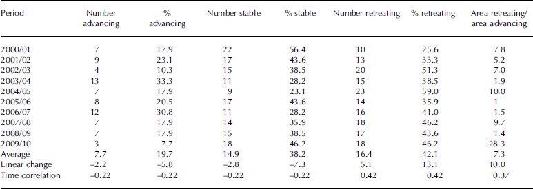
The statistics are influenced by ice-shelf area changes; for example, the 2009/10 cumulative glacier areal retreat is eight times the advance, extreme in this year because of the extreme area loss at Petermann glacier. The loss/gain ratio for the designated ice shelves has a minimum value of 0.1 in 2006/07 and 2008/09 and a maximum of 25.0 in 2010. The loss/gain ratio for glaciers is at a minimum of 0.8 in 2005/06, i.e. more gain than loss, and at a maximum of 66.7 in 2010. No strong correlation (>0.7) trend in this ratio is evident for ice shelves or glaciers.
Ensemble patterns
Because annual departures from the ensemble glacier trend are strongly influenced by the sporadic ice-shelf area losses, we compute trend and correlation statistics for glaciers and ice shelves separately. The six glaciers here classified as ice shelves are Petermann, ZachariÌ, NioghalvfjerdsbrÌ/79, Ostenfeld, Jakobshavn and Ryder. The rates of cumulative area change for glaciers and ice shelves in the 2000–09 period are well represented by linear least-squares fits, R = –0.98 and R = –0.94, with average rates of –64 and –41km2 a–1, respectively (Fig. 10a). By including 2010, the average ice-shelf loss rate is increased substantially by the 277 km2 Petermann glacier detachment, leading to an average decadal area loss rate of 53 km2 a–1 and reduced goodness of fit (R = –0.91). For glaciers, including 2010 leads to no change in the area loss rate and a slight increase in the linear fit correlation (R = –0.99).
(a) Cumulative net annual area changes for the 33 widest marine-terminating glaciers and six ice-shelf outlets to the Greenland ice sheet. (b) Anomalies from the linear fit excluding the extreme year 2010 for ice shelves.
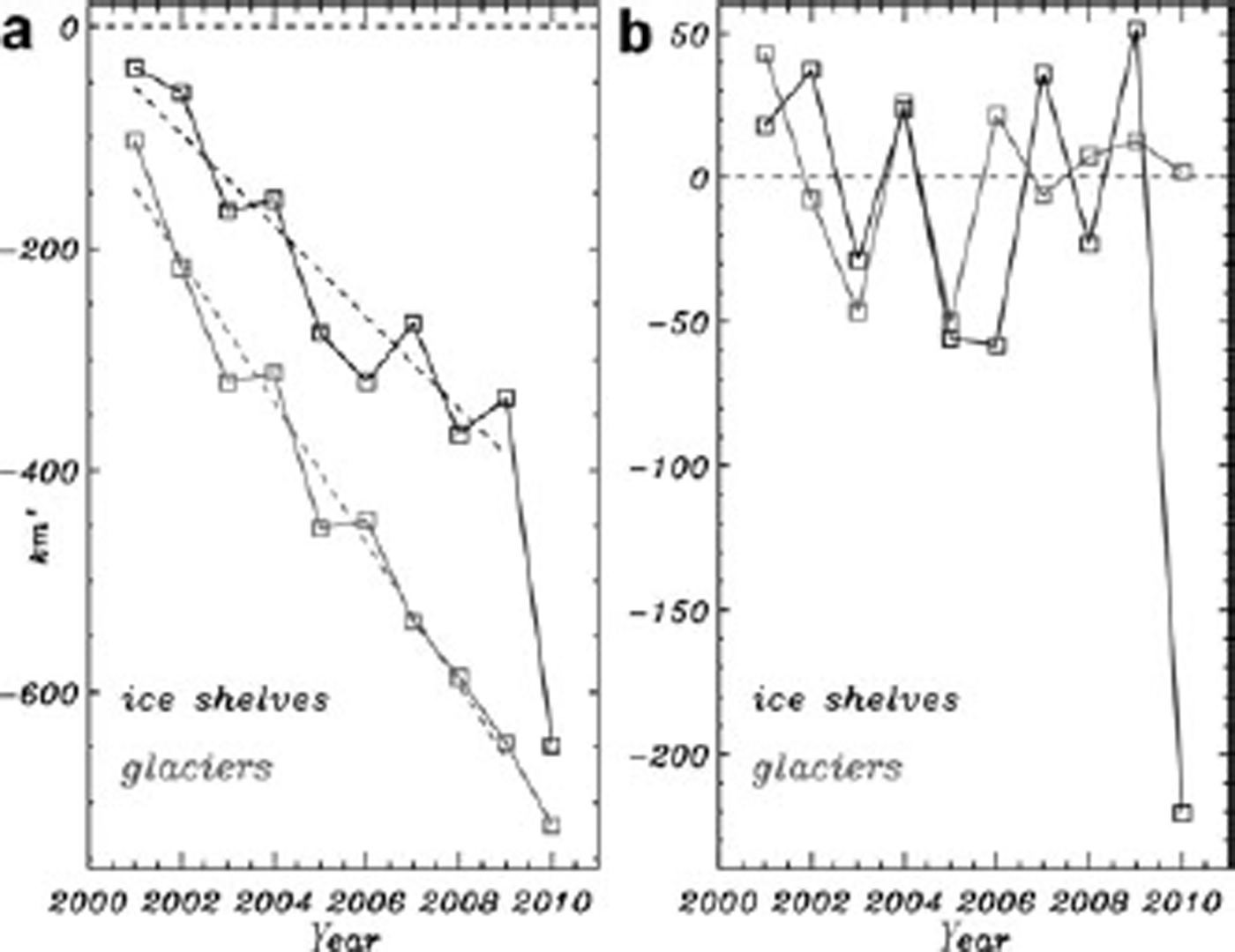
To evaluate the sensitivity to including 2010 or 2001 when the samples were either extreme or missing a few glaciers, we select different time intervals, 2001–10, 2002–10 and 2002–09, but find no consistent correlation (R < 0.2) between the glaciers and ice-shelf ensemble annual area change anomalies (see Fig. 10b). The only coincidence for the anomalies is in 2003.
Conclusions
This paper presents a description of a simple technique to assess Greenland glacier changes. Interannual area changes of marine-terminating outlets to the Greenland ice sheet are measurable using (0.25 km) MODIS imagery with an idealized precision of 1.0 km2. In most samples, the annually resolved area changes exceed this measurement precision. However, the absolute accuracy of the classification depends on decisions by the person who distinguishes between glacier ice, calf ice, sea ice, clouds, sea and land. In ideal cases when there is little or no sea ice the accuracy approaches the measurement precision. In marginal cases when images are blurry, have cloud contamination, shadows from land, and a less distinct calving front owing to increasing sea-ice concentration the absolute accuracy is low (<10km2).
The cumulative pattern of area change from the 39 glaciers surveyed indicates a linear (R = –0.91 to –0.94) and geographically widespread retreat pattern. The total net cumulative area change of the surveyed glaciers from the end of summer 2000 to 2010 is –1368km2, corresponding to an annual areal loss of 137 km2 a–1 including the Petermann glacier detachment in 2010. Excluding the Petermann calving in 2010, the 2000–09 deglaciation rate is 102 km2 a–1, well represented by a linear fit (R = –0.98). More than three-quarters of the area losses are from north Greenland glaciers (north of 72˚ N). The total width of marine-terminating front in our survey (424 km) retreated on average 3.2 km in the survey period.
Over the survey decade (2000–10), on average, the count of glaciers retreating is twice that advancing. A yet larger distinction is in terms of area, with the ratio of retreat and advance, on average, seven times the gain. We find no correlation (R < 0.2) between the glaciers and ice-shelf ensemble annual area change anomalies.
The area change data from this study are posted at http://bprc.osu.edu/~jbox/data/GAC/
Acknowledgements
The initial development of our survey was supported by US National Science Foundation (NSF) Office of Polar Programs award 0531306. The research was subsequently supported by The Ohio State University’s Climate Water and Carbon Program. We thank two anonymous reviewers, I. Howat and A. Mnchow for constructive comments, and T. Haran at the US National Snow and Ice Data Center, Boulder, Colorado, for assistance with MODIS data. Insight into the Petermann glacier front history was gained through discussion with H. Melling and K. Falkner. K. Markoff provided some very useful IDL graphics routines. This is Byrd Polar Research Center contribution No. 1398.


