


The demographic history of Greater Cahokia, from its peak in the eleventh century to its minimum at approximately AD 1350–1400 has received significant academic attention (Benson et al. Reference Benson, Pauketat and Cook2009; Bird et al. Reference Bird, Wilson, Gilhooly, Steinman and Stamps2017; Emerson Reference Emerson, Emerson, Koldehoff and Brennan2018; Gregg Reference Gregg1975; Kelly Reference Kelly, Riley and Reycraft2009; Milner Reference Milner2006:120–125; Munoz et al. Reference Munoz, Gruley, Massie, Fike, Schroeder and Williams2015; Pauketat and Lopinot Reference Pauketat, Lopinot, Pauketat and Emerson1997; Reed et al. Reference Reed, Bennett and Porter1968; White et al. Reference White, Stevens, Lorenzi, Munoz, Lipo and Schroeder2018, Reference White, Stevens, Lorenzi, Munoz, Schroeder, Cao and Bogdanovich2019), but efforts to understand the repopulation of the region by indigenous peoples prior to the establishment of European colonists at the close of the eighteenth century have been limited (Brown and Kelly Reference Brown and Kelly2010; Morgan Reference Morgan2010; Walthall and Benchley Reference Walthall and Benchley1987; Zitomersky Reference Zitomersky1994). The primary reasons for which the period after AD 1400 is understudied are (1) limited archaeological evidence for occupation of the watershed between AD 1400 and AD 1700 and (2) widespread acceptance of the Vacant Quarter hypothesis for regional abandonment between AD 1450 and 1550 (Cobb and Butler Reference Cobb and Butler2002; Edging Reference Edging2007; Emerson Reference Emerson1997:54; Fortier et al. Reference Fortier, Emerson and McElrath2006; Hanenberger Reference Hanenberger2003; Jackson Reference Jackson1998; Meeks and Anderson Reference Meeks, Anderson, Wingard and Hayes2013; Milner et al. Reference Milner, Emerson, Mehrer, Williams, Esary, Bareis and Porter1984, Reference Milner, Anderson, Smith, Brose and Mainfort2001; Williams Reference Williams1980, Reference Williams1983, Reference Williams, Dye and Cox1990, Reference Williams, Brown and Sasso2001).
The underappreciation of a post-Cahokia indigenous population in the region has contributed to a romanticization of Cahokia by some popular science writers who have depicted the eroding mounds as an example of total collapse (Diamond Reference Diamond2006:3) or attributed abandonment of the site to environmental mismanagement (Mann Reference Mann2006:303), leaving the reader with a sense of finality to the native population. Although researchers immersed in the Cahokia area literature are well aware of a post-Cahokia indigenous population (Brown and Kelly Reference Brown and Kelly2010; Morgan Reference Morgan2010; Walthall and Benchley Reference Walthall and Benchley1987; Zitomersky Reference Zitomersky1994), the popular emphasis on Cahokia's decline and abandonment may perpetuate the myth of the “vanishing Indian” that consciously or unconsciously exists in the minds of many Americans (see Lightfoot and Gonzalez Reference Lightfoot and Gonzalez2018; Silliman Reference Silliman, Oland, Hart and Frink2012; Wilcox Reference Wilcox2009, Reference Wilcox2010). This may be another reason that the period after AD 1400 is understudied—throughout the history of archaeological research, Native American disappearance has been emphasized more than Native American persistence (Rubertone Reference Rubertone2000; Wilcox Reference Wilcox2009).
Investigations of the significant population decline at Greater Cahokia indicate a protracted process and implicate a concatenation of many factors, including drought, flooding, climate change, the overexploitation of resources, political and religious instabilities, sociopolitical factionalism, intergroup conflict, ethnic diversity, and historically contingent circumstances, as well as the loss or departure of prominent individuals, kin groups, leaders, or deities (Benson et al. Reference Benson, Pauketat and Cook2009; Emerson Reference Emerson1997, Reference Emerson, Emerson, Koldehoff and Brennan2018; Emerson and Hedman Reference Emerson, Hedman and Faulseit2015; Kelly Reference Kelly, Riley and Reycraft2009; Lopinot and Woods Reference Lopinot, Woods and Scarry1993; Milner Reference Milner2006; Munoz Reference Munoz2015; Munoz et al. Reference Munoz, Gruley, Massie, Fike, Schroeder and Williams2015; Pauketat Reference Pauketat1994, Reference Pauketat, Emerson, Koldehoff and Brennan2018; Pauketat and Lopinot Reference Pauketat, Lopinot, Pauketat and Emerson1997; White et al. Reference White, Stevens, Lorenzi, Munoz, Schroeder, Cao and Bogdanovich2019). In contrast to the considerable attention that has been paid to the dissolution and abandonment of Greater Cahokia, what happened after Cahokia's depopulation is poorly understood. Here, we present post–AD 1400 demographic trends from a fecal stanol population reconstruction of Horseshoe Lake, Illinois (White et al. Reference White, Stevens, Lorenzi, Munoz, Lipo and Schroeder2018)—along with information from archaeological, historical, and environmental sources—to understand the resilience of indigenous peoples during the post-Mississippian period.
Horseshoe Lake Fecal Stanol Population Reconstruction
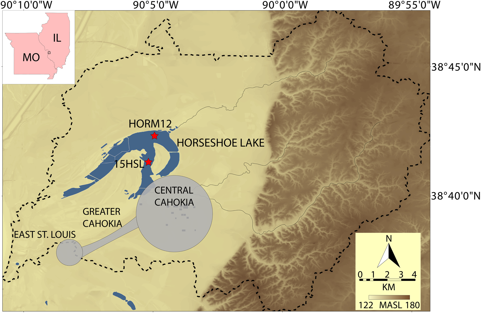
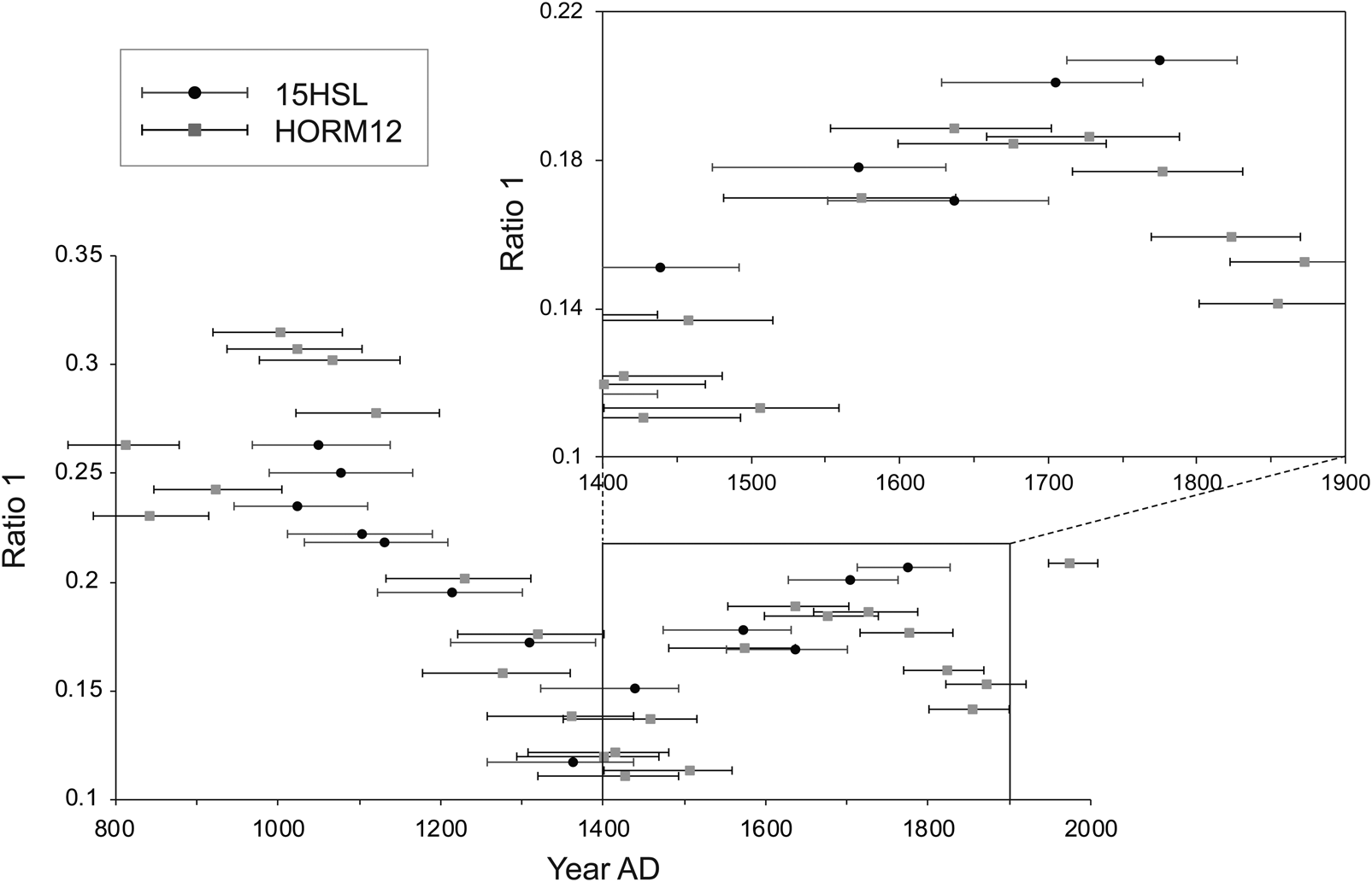
Horseshoe Lake is a large oxbow lake of the Mississippi River that contains within its watershed the Cahokia archaeological complex (Figure 1). White and colleagues (Reference White, Stevens, Lorenzi, Munoz, Lipo and Schroeder2018) used variations in the concentrations of fecal stanol molecules retained in lake sediments from two cores, HORM12 and 15HSL, to create a population reconstruction of the lake's watershed (Figure 2). The two cores were correlated on the basis of stratigraphic variation in layers interpreted as flood deposits (Munoz et al. Reference Munoz, Gruley, Massie, Fike, Schroeder and Williams2015) and loss-on-ignition (LOI) data (White et al. Reference White, Stevens, Lorenzi, Munoz, Schroeder, Cao and Bogdanovich2019), and they share the age-depth model established by Munoz and others (Reference Munoz, Schroeder, Fike and Williams2014) for HORM12 constrained by nine radiocarbon dates on terrestrial plant macrofossils and the rise of Ambrosia (ragweed) pollen, marking the onset of widespread Anglo-American agricultural clearance at approximately AD 1850. Coprostanol is a fecal stanol molecule primarily produced by the bacterial degradation of cholesterol in the guts of humans that can persist in sediments for hundreds to thousands of years (Bull et al. Reference Bull, Simpson, van Bergen and Evershed1999; Simpson et al. Reference Simpson, van Bergen, Perret, Elhmmali, Roberts and Evershed1999; Sistiaga et al. Reference Sistiaga, Berna, Laursen and Goldberg2014; Vachula et al. Reference Vachula, Huang, Longo, Dee, Daniels and Russell2019). Although other mammals—including donkeys, seals, horses, goats, and cattle—produce coprostanol, only sheep and pigs are known to generate sufficient quantities that could mask changes in human stanol concentration (Bull et al. Reference Bull, Lockheart, Elhmmali, Roberts and Evershed2002; Leeming et al. Reference Leeming, Ball, Ashbolt and Nichols1996; Martins et al. Reference Martins, Montone, Gamba and Pellizari2005; Prost et al. Reference Prost, Birk, Lehndorff, Gerlach and Amelung2017), and neither domesticate was present in the Cahokia area prior to sustained European settlement (Mann Reference Mann2012). Once introduced into the environment as a component of feces, coprostanol is typically buried in situ or transported during rain events and deposited in a basin, such as a lake. We analyzed two sediment cores from opposite sides of Horseshoe Lake to address the issue that a single core may not represent the entire watershed (White et al. Reference White, Stevens, Lorenzi, Munoz, Lipo and Schroeder2018). We interpret the Horseshoe Lake fecal stanol record as representative of the watershed because HORM12 and 15HSL show parallel trends in fecal stanol data, and activities such as hunting, fishing, and gathering likely expanded the indigenous presence on the landscape throughout much of the watershed.
The modern Horseshoe Lake watershed, shown as the black dashed line. Coring sites are indicated by stars. Central Cahokia is approximated by deposits that are within the large circle. Greater Cahokia includes Central Cahokia and a region extending to East St. Louis. Base map elevation data are derived from the National Elevation Dataset (Gesch et al. Reference Gesch, Oimoen, Greenlee, Nelson, Steuck and Tyler2002). Adapted from White and colleagues (Reference White, Stevens, Lorenzi, Munoz, Lipo and Schroeder2018). (Color online)
Horseshoe Lake stanol data plotted as coprostanol/5α-cholestanol ratio. Error bars represent temporal uncertainty reported as 2σ (95%) confidence generated by the Clam 2.2 model (Munoz et al. Reference Munoz, Schroeder, Fike and Williams2014). The lower left plot shows all fecal stanol data from White and colleagues (Reference White, Stevens, Lorenzi, Munoz, Lipo and Schroeder2018), and the upper right plot shows fecal stanol data from AD 1400 to 1900.

Due to its prevalence in human feces and recalcitrance in sediments, variations in coprostanol concentration may be linked to changes in the relative size of a population within a region (D'Anjou et al. Reference D'Anjou, Bradley, Balascio and Finkelstein2012). To account for variations in degradation rate and low stanol abundance, the concentrations of coprostanol are reported in comparison to 5α-cholestanol, following Grimalt and colleagues (Reference Grimalt, Fernandez, Bayona and Albaiges1990):

5α-cholestanol is formed from the degradation of cholesterol by soil microbial communities (Bull et al. Reference Bull, Lockheart, Elhmmali, Roberts and Evershed2002). By relating coprostanol to 5α-cholestanol, we make a comparison of stanol input and preservation in a specific environment (5α-cholestanol) to stanol input from feces (coprostanol). Consequently, high values of ratio (1) indicate a large presence of humans in the region and low values indicate a small human presence. Horseshoe Lake fecal stanol data (White et al. Reference White, Stevens, Lorenzi, Munoz, Lipo and Schroeder2018) record the timing of three important demographic events following Greater Cahokia's population maximum and prior to the arrival of European colonists: the Cahokia population minimum at AD 1400, the initiation of indigenous repopulation by AD 1500, and the post-Cahokia population maximum reached by approximately AD 1650 (Figure 2). The Cahokia area experienced a continuous population decline from approximately AD 1100 to 1350–1400 in the much discussed “Cahokia collapse” (Delcourt and Delcourt Reference Delcourt and Delcourt2004:115; Emerson Reference Emerson, Emerson and Lewis1991, Reference Emerson2002; Emerson and Hedman Reference Emerson, Hedman and Faulseit2015; Kelly Reference Kelly, Riley and Reycraft2009; Milner Reference Milner1986, Reference Milner1990, Reference Milner2006; Pauketat Reference Pauketat2004; Pauketat and Lopinot Reference Pauketat, Lopinot, Pauketat and Emerson1997). Following this period, the fecal stanol record indicates that the watershed's population remained relatively low during the fifteenth century, but it began to increase after AD 1500. This suggests that the region's demographic nadir was short lived. Despite the dearth of archaeological evidence for a post-AD 1500 occupation, the fecal stanol record indicates that people were again living in the Horseshoe Lake watershed.
The watershed's population increased into the sixteenth century to a height at approximately AD 1650. The fecal stanol ratio values then plateau to AD 1700 before declining through the nineteenth century. Outlier data points from core 15HSL are present at approximately AD 1710 and 1775, possibly resulting from laboratory or chronometric uncertainties in the age model and core correlation. Alternatively, these data points may indicate that a historic population was centered on the south end of the lake closer to 15HSL than HORM12.
Discussion
The fecal stanol record provides a proxy of population change in the Horseshoe Lake watershed, but additional information is needed to understand the cultural and environmental factors that influenced these demographic trends. We include evidence from historical, archaeological, and environmental sources to construct a narrative of population change in the Horseshoe Lake watershed after AD 1400.
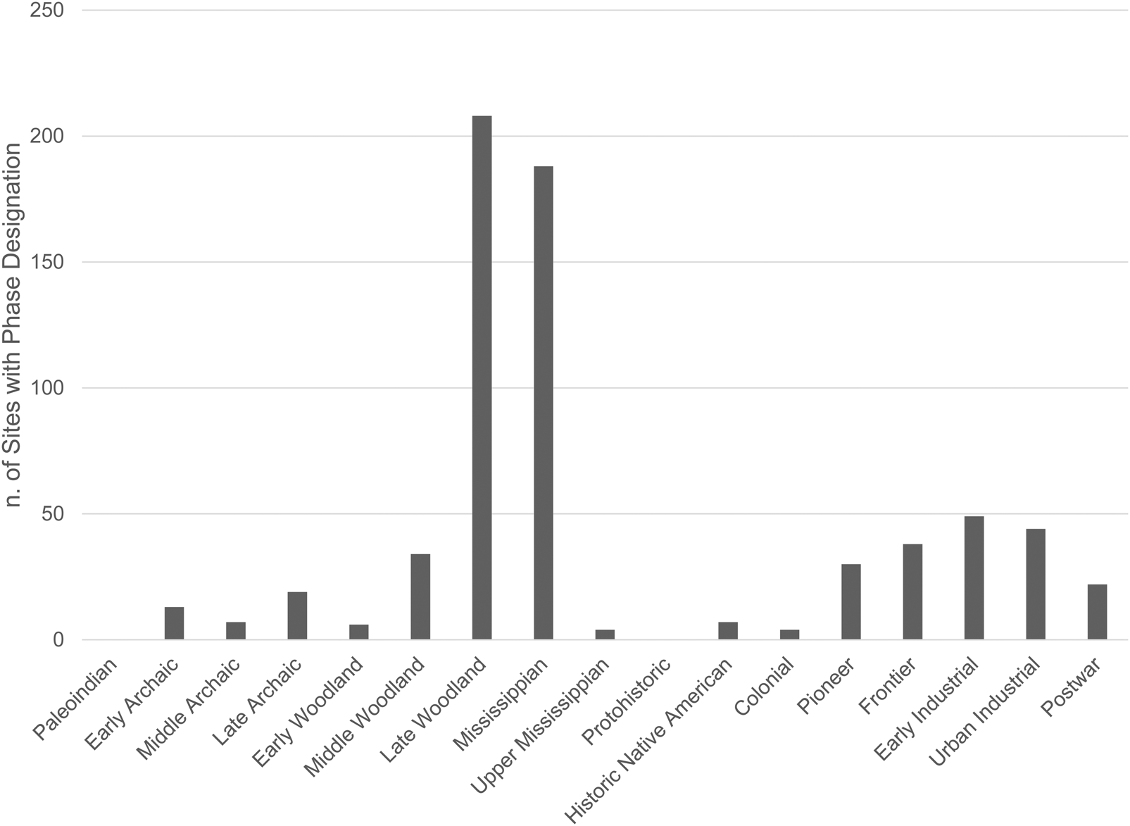
Greater Cahokia's regional population was at its lowest in the fifteenth century, marking the end of a nearly continuous demographic decline that began 300 years earlier (Emerson Reference Emerson, Emerson, Koldehoff and Brennan2018; Milner Reference Milner2006; Pauketat and Lopinot Reference Pauketat, Lopinot, Pauketat and Emerson1997; White et al. Reference White, Stevens, Lorenzi, Munoz, Lipo and Schroeder2018). Numerous explanations for the decline have been put forward (Benson et al. Reference Benson, Pauketat and Cook2009; Bird et al. Reference Bird, Wilson, Gilhooly, Steinman and Stamps2017; Emerson and Hedman Reference Emerson, Hedman and Faulseit2015; Kelly Reference Kelly, Riley and Reycraft2009; Lopinot and Woods Reference Lopinot, Woods and Scarry1993; Munoz et al. Reference Munoz, Gruley, Massie, Fike, Schroeder and Williams2015; Pauketat Reference Pauketat, Emerson, Koldehoff and Brennan2018; Pauketat et al. Reference Pauketat, Fortier, Alt and Emerson2013; Pompeani et al. Reference Pompeani, Hillman, Finkenbinder, Bain, Correa-Metrio, Pompeani and Abbott2019; White et al. Reference White, Stevens, Lorenzi, Munoz, Schroeder, Cao and Bogdanovich2019), but its reversal has not been discussed. In eastern North America, protohistoric sites are identified on the basis of native-made materials in association with European trade goods in locations that do not appear on maps and that are not mentioned in historic records or European travel accounts (Ehrhardt Reference Ehrhardt2010; Mazrim and Esarey Reference Mazrim and Esarey2007). Definitive archaeological evidence for occupation of the Cahokia region during the protohistoric period (approximately AD 1550–1670) is scant, but given that archaeologists have poor control over the kinds of artifacts that may have been distinctive to late precontact sites (sixteenth- to seventeenth-century European trade goods need to be present to classify a site as protohistoric) and that many native groups were highly mobile at this time, it is not surprising that such sites are underrepresented in state site files (Ehrhardt Reference Ehrhardt2010; Lewis Reference Lewis, Dye and Cox1990; Mazrim and Esarey Reference Mazrim and Esarey2007; Milner and Chaplin Reference Milner and Chaplin2010; Milner et al. Reference Milner, Anderson, Smith, Brose and Mainfort2001). For example, a search of the Illinois State Museum site records within three miles of Horseshoe Lake revealed no previously recorded sites with protohistoric components and just two sites with Oneota (Upper Mississippian) components, the Sponemann and Sand Drive sites, both dating to the fourteenth century (Figure 3; Jackson Reference Jackson1998; Jackson et al. Reference Jackson, Fortier and Williams1992; Pauketat et al. Reference Pauketat, Rees and Pauketat1998:90). In addition, small amounts of Oneota materials have been recovered from Mound 51, Mound 66, Mounds 19–20, Tract 15B, and the Powell Tract at Cahokia. These materials likely date to the fourteenth century, but some might represent a small fifteenth-century Oneota presence at Cahokia (Bareis and Lathrap Reference Bareis and Lathrap1962; Brown and Kelly Reference Brown and Kelly2010; Jackson Reference Jackson1998; O'Brien Reference O'Brien1972).
Temporal phases identified at previously recorded archaeological sites within three miles of Horseshoe Lake (approximate extent of the Horseshoe Lake watershed). Source: Illinois State Museum.
Elsewhere in the American Bottom region, Oneota sites include the 78th Street, Range, and Booker T. Washington (also called Greene) sites near the base of the bluff over 7 km south of Cahokia; Stolle Quarry on the edge of the bluff about 20 km south of Cahokia; McDonough Lake and Ringering, 5–7 km north of Cahokia; and Pere Marquette State Park, just north of the American Bottom near the confluence of the Illinois and Mississippi Rivers (Brown and Kelly Reference Brown and Kelly2010; Hall and Vogel Reference Hall, Vogel and Fowler1963; Hanenberger Reference Hanenberger2003; Jackson Reference Jackson1998; Milner et al. Reference Milner, Emerson, Mehrer, Williams, Esary, Bareis and Porter1984; Munson Reference Munson1971:Figure 12q, Figure 21d; Perino Reference Perino1959; Rinaldo Reference Rinaldo1937; Wells and Holley Reference Wells and Holley1993). The materials recovered from Cahokia and the 78th Street site date to the fourteenth century (Jackson Reference Jackson1998; Wells and Holley Reference Wells and Holley1993), the Oneota component at Range has been dated to approximately AD 1500–1650 (Hanenberger Reference Hanenberger2003:377, 434; cf. Hollinger Reference Hollinger and Green1995:157–158), and it has been suggested that the Oneota components at Booker T. Washington, Stolle Quarry, and Ringering also fall within this range (Jackson Reference Jackson1998). In short, archaeological evidence of an Oneota presence in the American Bottom is sparse, most of the sites lie outside the Horseshoe Lake watershed, and all of the sites are small, most likely representing short-term occupation of isolated farmsteads.
Additionally, historic-era Illinois hunting camps rarely contain diagnostic materials necessary to make a temporal and cultural determination (Nolan Reference Nolan2010). These factors, in addition to the mixing of archaeological material, sedimentation of the Mississippi River Valley, historic and modern urban development, and limited access to private lands, make the identification of protohistoric and early historic archaeological sites difficult (Ehrhardt Reference Ehrhardt2010). Furthermore, the research emphasis on Mississippian archaeology may create a recording bias that impacts the identification of Illinois material culture during archaeological survey. Van Thienen (Reference Van Thienen2017) found a “Germanic bias” that led to an underrepresentation of late Roman archaeological sites in Flanders due to a traditional narrative that northern Gaul was abandoned by the Romans around AD 275. It is possible that a similar “Mississippian bias” exists in the Cahokia region—why look for post-Cahokia material if you do not expect to find it?
Ethnohistoric Information
A lack of archaeological evidence does not preclude the existence of a protohistoric population in the Horseshoe Lake watershed. The Cahokia subgroup of the Illinois Indians was present in the vicinity of Horseshoe Lake in the early eighteenth century (Brown Reference Brown1979; Fowler Reference Fowler1997; Morgan Reference Morgan2010:66; Walthall and Benchley Reference Walthall and Benchley1987; Zitomersky Reference Zitomersky1994). Various accounts from the early eighteenth century describe widespread movement of Cahokia, Tamaroa, and other subgroups of the Illinois in the broader region in response to the growing presence of Europeans and the threat of raiding from the Iroquois (Brown and Sasso Reference Brown, Sasso, Brose, Cowan and Mainfort2010; Morgan Reference Morgan2010; Temple Reference Temple1958). From direct historical analogy (Brain Reference Brain, Dunnell and Hall1978; Deal Reference Deal2017; Wedel Reference Wedel1959), it is likely that a population similar to the Cahokia subgroup occupied the Cahokia region at some point between the depopulation of Cahokia and the historic period. Illinois subsistence strategies were more similar to seasonally mobile Oneota settlement-subsistence systems and distinctly different from the sedentary agricultural practices of Mississippians (Schroeder Reference Schroeder2004). The Illinois were semisedentary and practiced agriculture at villages near major river drainages or lakes that were occupied primarily in the spring and fall (Brown Reference Brown1979; White Reference White1996). A majority of the group would leave for a summer bison hunt, and after the fall harvest, the entire village population would reorganize into smaller winter hunting camps (Brown Reference Brown1979; Hauser Reference Hauser1976; Walthall et al. Reference Walthall, Norris, Stafford and Emerson1992; White Reference White1996). Additionally, war parties would leave winter camps early in the year to raid other groups (Walthall et al. Reference Walthall, Norris, Stafford and Emerson1992). Settlement-subsistence systems of earlier Oneota period (AD 1400–1700; Fortier et al. Reference Fortier, Emerson and McElrath2006) groups included mixed horticulture, communal bison and elk hunting, and a greater degree of mobility than Mississippian populations (Benn Reference Benn1989; Gibbon Reference Gibbon1972; Hart Reference Hart1990). Consequently, Illinois habitation or Oneota sites would yield less archaeological material than similarly sized Mississippian sites because they were seasonally occupied.
Paleoenvironmental Information
The fecal stanol data indicate the watershed's repopulation occurred during an ecological transition in the Cahokia region. The vegetation communities around Horseshoe Lake inferred from fossil pollen data were dynamic throughout the prehistoric and historical periods (Munoz et al. Reference Munoz, Schroeder, Fike and Williams2014). Fossil pollen assemblages from Horseshoe Lake sediments described by Munoz (Reference Munoz2015) and Munoz and colleagues (Reference Munoz, Schroeder, Fike and Williams2014) identified an increase in both upland and floodplain tree pollen between AD 1500 and 1800 that was attributed to a reduction in agricultural production following Cahokia's decline. Grass pollen (Poaceae) and cellular charcoal derived from the burning of grasses increased over this time period, implying that grasslands expanded in the region at this time (Morrissey Reference Morrissey2015; Munoz Reference Munoz2015). The expansion of grasslands into this region coincides with the expansion of the bison population in Illinois (Brown and Sasso Reference Brown, Sasso, Brose, Cowan and Mainfort2010; McMillan Reference McMillan and McMillan2006; Morrissey Reference Morrissey2015; Munoz Reference Munoz2015; Tankersley Reference Tankersley, Croes, Hawkins and Isaac1992) and occurs alongside an increase in Horseshoe Lake fecal stanol values (Figure 4). The concomitant increase in grassland extent, burning, and human population levels implies that indigenous groups visited the region for hunting and possibly game management through periodic burning of grasslands.
HORM12 and 15HSL fecal stanol ratio values with interpreted trend line (a) plotted against (b) HORM12 grass pollen counts (Munoz, Reference Munoz2015), (c) HORM12 cellular charcoal counts (Munoz, Reference Munoz2015), (d) Martin Lake δ18O values (Bird et al. Reference Bird, Wilson, Gilhooly, Steinman and Stamps2017), (e) regional PHDI reconstruction (Stambaugh et al. Reference Stambaugh, Guyette, McMurry, Cook, Meko and Lupo2011), and (f) regional PDSI reconstruction (Benson et al. Reference Benson, Pauketat and Cook2009). Shaded vertical bars indicate the interpreted population low (red, left) and population high (blue, right) over this time range. (Color online)
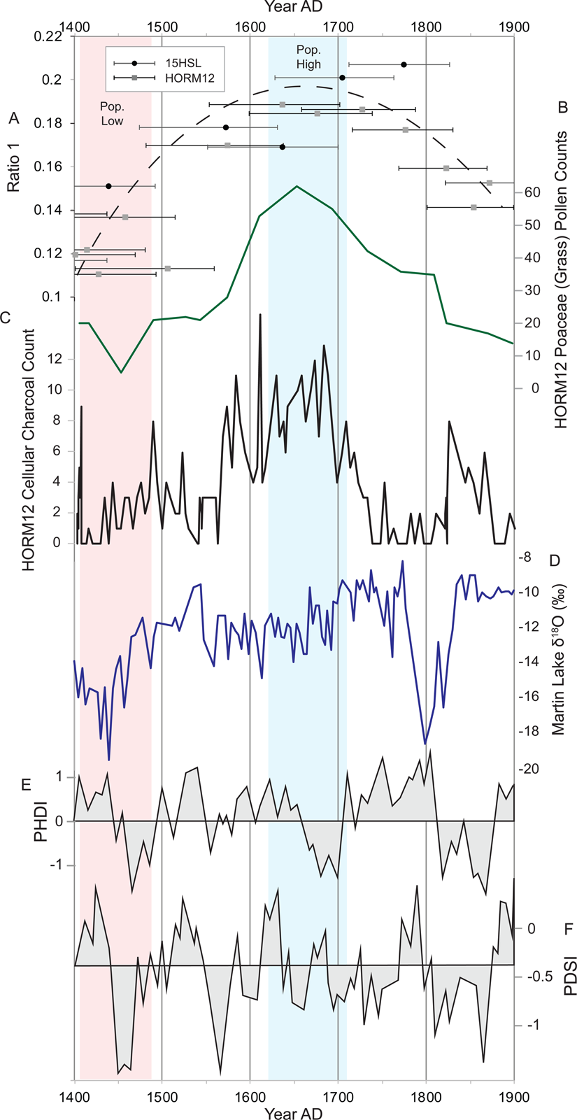
Low values in the fecal stanol record coincide with droughts, one in the mid-fifteenth century and one at the turn of the nineteenth century. Tree-ring-inferred Palmer Hydrological Drought Index (PHDI) reconstruction records from Missouri and Iowa (Stambaugh et al. Reference Stambaugh, Guyette, McMurry, Cook, Meko and Lupo2011) and Palmer Drought Severity Index (PDSI; Benson et al. Reference Benson, Pauketat and Cook2009; Cook et al. Reference Cook, Seager, Cane and Stahle2007) reconstruction records from Missouri and Illinois display negative values in the mid-fifteenth century and at the onset of the nineteenth century, indicating regional drought conditions (Figure 4). A negative excursion in PDSI values in the sixteenth century, however, is not shown by the PHDI values. The fifteenth and nineteenth century droughts are also captured by δ 18O values of endogenic carbonate from Martin Lake in northeastern Indiana (Bird et al. Reference Bird, Wilson, Gilhooly, Steinman and Stamps2017; Figure 4). Bird and colleagues (Reference Bird, Wilson, Gilhooly, Steinman and Stamps2017) interpreted variations in δ 18O as responses to changing precipitation source and seasonality, with negative excursions indicating summer season droughts. It is notable that the seventeenth-century post-Mississippian population maximum occurs during a period of little variation in the PHDI, PDSI, and δ 18O records, suggesting a time of hydroclimatic stability. Although precipitation would not have affected semisedentary Illinoian groups as directly as Mississippian agriculturalists, a stable environment may have supported regional population growth through more predictable and reliable resources. The watershed's post-Mississippian population was lowest during times of precipitation variation and highest during a time of relative precipitation stability.
Historical Information
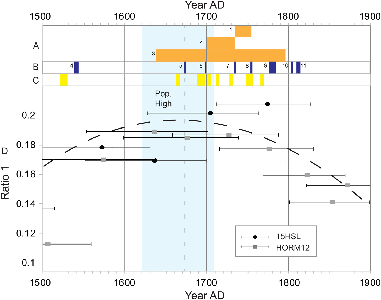
Although the Spanish Hernando de Soto expedition of AD 1539–1543 reached the lower Mississippi River Valley (Hudson Reference Hudson1998:284), there is no evidence of a sustained European presence in the Cahokia region prior to the eighteenth century (Blasingham Reference Blasingham1956a; Ekberg Reference Ekberg1998; Morgan Reference Morgan2010; Temple Reference Temple1958; Zitomersky Reference Zitomersky1994). Consequently, the repopulation of the Horseshoe Lake watershed in the sixteenth and seventeenth centuries following a minimum in the fifteenth century is attributable only to indigenous groups. This is significant because researchers have previously suggested that indigenous populations were in decline during this period from Old World diseases that spread across North America in advance of European colonists (Dobyns Reference Dobyns1983; Dunnell Reference Dunnell and Thomas1991). The fecal stanol data, however, indicate that population and/or human activity in the region actually increased in the sixteenth and seventeenth centuries, despite multiple epidemics known to have occurred in the Caribbean, Mexico, the eastern United States, and Canada over this time period (Figure 5; Crosby Reference Crosby1976; Dobyns Reference Dobyns1983; Kelton Reference Kelton2007; Larsen et al. Reference Larsen, Ruff, Schoeninger, Hutchinson, Verano and Ubelaker1992; Ramenofsky Reference Ramenofsky1987; Snow Reference Snow1996; Snow and Lanphear Reference Snow and Lanphear1988; Thornton Reference Thornton1987; Verano and Ubelaker Reference Verano and Ubelaker1992; Ward and Davis Reference Ward and Stephen Davis1991). The stanol data imply that the impact of newly introduced diseases in the sixteenth and early seventeenth centuries in the interior of the southeastern United States was not as great as in coastal areas (Kelton Reference Kelton2007), but it is possible that immigration to the Horseshoe Lake watershed masked population loss to disease. Furthermore, the population increase after AD 1500 has implications for the Vacant Quarter hypothesis that suggested widespread abandonment of a region extending from the American Bottom to the southern border of Missouri and Kentucky, up the Ohio River to the eastern end of Indiana, and south along the Tennessee River into northeastern Mississippi and northwestern Alabama between AD 1450 and 1550 (Williams Reference Williams, Dye and Cox1990). If the American Bottom saw a protohistoric reoccupation from AD 1500 to 1700, then the abandonment of the Vacant Quarter was neither as widespread as originally proposed nor wholly synchronous—as some have suggested (Cobb and Butler Reference Cobb and Butler2002; Meeks and Anderson Reference Meeks, Anderson, Wingard and Hayes2013)—and R. Barry Lewis may have been correct in his suggestion that archaeologists have poor temporal control over artifacts diagnostic of that time interval (Lewis Reference Lewis, Dye and Cox1990).
HORM12 and 15HSL fecal stanol ratio values with interpreted trend line (d) plotted against (a) historic events of Cahokia and Illinois groups, (b) historic events of European groups, and (c) eastern North American epidemics (Blasingham Reference Blasingham1956a, Reference Blasingham1956b; Dobyns Reference Dobyns1983; Zitomersky Reference Zitomersky1994). The vertical dashed line indicates the arrival of Europeans to the Horseshoe Lake watershed. Key to historic events: 1 = Cahokia occupy village near Horseshoe Lake (Walthall and Benchley Reference Walthall and Benchley1987), 2 = Cahokia occupy village near Cahokia/Tamaroa mission (Walthall and Benchley Reference Walthall and Benchley1987), 3 = intermittent warfare and skirmishes by Illinois tribes (Blasingham Reference Blasingham1956b; Morrissey Reference Morrissey2015; Rogers Reference Rogers2016), 4 = de Soto expedition (Hudson Reference Hudson1998), 5 = Marquette expedition (Mazrim and Esarey Reference Mazrim and Esarey2007), 6 = establishment of Cahokia/Tamaroa mission (Zitomersky Reference Zitomersky1994), 7 = establishment of River L'Abbe mission (Walthall and Benchley Reference Walthall and Benchley1987), 8 = closure of River L'Abbe mission (Walthall and Benchley Reference Walthall and Benchley1987), 9 = cantine operation near Monk's Mound (Walthall and Benchley Reference Walthall and Benchley1987), 10 = settlement of French farmers near Monk's Mound (Walthall and Benchley Reference Walthall and Benchley1987), 11 = occupation of Monk's Mound by Trappist monks (Walthall and Benchley Reference Walthall and Benchley1987). (Color online)
The fecal stanol values plateau following a population maximum at approximately AD 1650. Although Europeans are not documented in the region until the Jacques Marquette expedition of AD 1673 (Ehrhardt Reference Ehrhardt2010; Mazrim and Esarey Reference Mazrim and Esarey2007), it is possible that diseases began to be transmitted to the region from European-indigenous interactions to the north and east. Hull (Reference Hull, Voss and Casella2012), for example, attributed a population decline in the Awahnichi of eastern California to epidemics that occurred decades before a sustained European presence was established. Frequent indigenous warfare and mobility known to have occurred in seventeenth-century Illinois, however, are better understood drivers of population change during this period (Ehrhardt Reference Ehrhardt2010; Mazrim and Esarey Reference Mazrim and Esarey2007; Morrissey Reference Morrissey2015; Rogers Reference Rogers2016; Zitomersky Reference Zitomersky1994). Illinois groups were engaged in warfare with multiple indigenous groups—and later with Europeans to the east and west—throughout the seventeenth century and into the eighteenth century, most notably against the Iroquois after the start of the Beaver Wars in the 1640s (Brown Reference Brown1979; Morrissey Reference Morrissey2015; Temple Reference Temple1958; White Reference White1991). Indigenous warfare in the Mississippi River Valley during this time was based on replacement: as groups lost members to violence, those members were replaced through a complex system of raids for slaves from foreign groups (Alt Reference Alt and Cameron2008; Morrissey Reference Morrissey2015; Peregrine Reference Peregrine and Cameron2008). This system of population replacement may have contributed to the population plateau interpreted from Horseshoe Lake fecal stanol data (Figure 5). Additionally, the high mobility of Illinois groups for both subsistence and political reasons may appear in the fecal stanol record as a plateau as the signals of population rise and loss from movement cancel out. In any case, it is clear that the beginning of the post-Mississippian decline of the region's indigenous population was not passive.
European settlement in the region began in AD 1699 with the establishment of the Cahokia/Tamaroa mission by the French Seminary of Foreign Missions approximately 15 km southwest of Horseshoe Lake (Figure 5; Ekberg Reference Ekberg1998; Gums Reference Gums1988; Morgan Reference Morgan2010; Walthall and Benchley Reference Walthall and Benchley1987). The mission was founded next to a village of the Tamaroa subgroup of the Illinois, but after the Tamaroa joined the Kaskaskia in AD 1701, the mission became associated primarily with members of the Cahokia group (Walthall and Benchley Reference Walthall and Benchley1987). In AD 1735, members of the Cahokia tribe living at the Cahokia/Tamaroa mission relocated to the Horseshoe Lake region due to tensions with French colonists, and the River L'Abbe mission was established on the first terrace of Monk's Mound within the Cahokia archaeological complex to continue the goals of the French Seminary (Morgan Reference Morgan2010:66; Walthall and Benchley Reference Walthall and Benchley1987). Although the River L'Abbe mission was not large, its construction is significant because it means there was a large enough native population in the Cahokia vicinity to justify building and maintaining a mission. The new mission operated until AD 1752, when the Cahokia are thought to have left the region (Walthall and Benchley Reference Walthall and Benchley1987). Following the closure of the River L'Abbe mission, a trading post known as the Cantine operated close to Monk's Mound from AD 1776 to 1784. French farmers settled just east of Monk's Mound in AD 1804, and a group of Trappist monks occupied Monk's Mound from AD 1809 to 1813 (Walthall and Benchley Reference Walthall and Benchley1987). By the 1830s, land in the Horseshoe Lake watershed had been appointed to Euro-American settlers (McAdams Reference McAdams1882).
Fecal stanols values indicate that the watershed's population was in decline by the middle of the eighteenth century. The majority of the watershed's population in the first half of the eighteenth century was most likely indigenous; Zitomersky (Reference Zitomersky1994:203) estimates that approximately 1,700 Cahokians were present in the vicinity of the Cahokia/Tamaroa mission in AD 1701 along with 14 French missionaries and colonists. Although Zitomersky (Reference Zitomersky1994:321) estimates that the Cahokian population fell to 350 people by 1752, the French population had only risen to 113. Consequently, the fecal stanol decline in the late eighteenth century likely represents a decline in the indigenous population, despite a slowly increasing number of Europeans arriving to the watershed.
The late eighteenth-century indigenous population decline within the Horseshoe Lake watershed corresponds with multiple biological, social, and environmental events that occurred in the region (Figure 5), including several smallpox and measles epidemics, particularly during the first half of the eighteenth century (Blasingham Reference Blasingham1956b; Koch et al. Reference Koch, Brierley, Maslin and Lewis2019; Morrissey, Reference Morrissey2015; Zitomersky Reference Zitomersky1994). The near coincidence of the fecal stanol maximum and the arrival of Europeans to the region followed by multiple recorded epidemics suggest that disease played a role in the depopulation of the Horseshoe Lake watershed. Other agents of change, however, also exist.
Blasingham (Reference Blasingham1956b) identified warfare as a major cause of Illinois population loss. Frequent warfare with other indigenous groups continued after the arrival of the French through the eighteenth century (Figure 5). The French frequently allied with the Illinois as part of a much larger system of Native American and European alliances and adversaries on the western colonial frontier (Morrissey Reference Morrissey2015). The practice of captive-taking continued in the eighteenth century and likely played a role in Illinois population change. Additionally, the Illinois were frequently mobile, and much of the watershed's decline could have resulted from movements of the Cahokia tribe out of the watershed. The efforts of missionaries to convert Native Americans to Catholicism and enforce monogamy may also have led to a reduction in births (Morgan Reference Morgan2010:67). Researchers have not previously implicated environmental changes in the decline of the Illinois populations, but the rapid decrease of grass pollen in Horseshoe Lake's sediments at the beginning of the eighteenth century suggests a loss of prairie that created poor conditions for bison hunting, making the watershed an unattractive destination for Illinois groups. In addition, the pronounced negative excursions of PHDI, PDSI, and Martin Lake δ 18O values at the close of the eighteenth century indicate that drought conditions ended a period of relative hydroclimatic stability that had coincided with the region's post-Mississippian population maximum (Figure 4; Benson et al. Reference Benson, Pauketat and Cook2009; Bird et al. Reference Bird, Wilson, Gilhooly, Steinman and Stamps2017; Stambaugh et al. Reference Stambaugh, Guyette, McMurry, Cook, Meko and Lupo2011).
Fecal stanol values remain low into the nineteenth century, corresponding to emigration of the remaining Cahokia group to join other Illinois populations (Hauser Reference Hauser1976; Walthall and Benchley Reference Walthall and Benchley1987) and a low immigration rate of European settlers. The settler population of the entire Illinois Territory upon its creation in 1809 was recorded as 9,090, and the 1820 U.S. census listed 13,550 inhabitants in Madison County, which at the time comprised a significant area of Illinois that included the Cahokia site (McAdams Reference McAdams1882). Although early nineteenth-century Anglo-American settlers recognized the agricultural potential of the American Bottom, they often described the ponds and lakes as emitting noxious fumes and large quantities of “miasm” that made it an unhealthy place to reside (Mitchell Reference Mitchell1837:18; Peck Reference Peck1837:6). Indeed, Charles Dickens, traveling from St. Louis to visit the Looking-Glass Prairie in Illinois in 1842, referred to it as “an ill-favoured Black Hollow” (Dickens Reference Dickens1842:66). By the mid-nineteenth century, canals and ditches had been constructed to drain the wetlands and open up more land to cultivation and development (McAdams Reference McAdams1882:475), but the population residing in the bottomlands remained low. Even in 1880, the population of the township that encompasses Horseshoe Lake was only 1,466, just 3% of the population of the entire county (Census Office Reference Office1880:387; McAdams Reference McAdams1882:503). Consequently, the low values of fecal stanols in the latter half of the nineteenth century may be related as much to low population as to a possible divergence of fecal input to Horseshoe Lake through the introduction of plumbing and other formal receptacles for fecal waste.
It is difficult to determine the number of native people who remained in the Cahokia vicinity, but many of those who left and their descendants were forcibly moved to Oklahoma during the first half of the nineteenth century (Robertson Reference Robertson1992; White Reference White1996). The depopulation of Illinois groups has been taken to mean that “today the Illinois tribe is culturally extinct” (Hauser Reference Hauser1976:138); however, the Peoria Tribe of Indians of Oklahoma, who assimilated other Illinois subgroups in the nineteenth century, is a sovereign community with over 2,900 members, including members in Illinois, and is active in the state through consultation efforts with government agencies (Oklahoma Indian Affairs Commission Reference Oklahoma Indian Affairs Commission2011; Logan Pappenfort, personal communication 2018). Regional depopulation and relocation do not equate to cultural extinction. The historic-era indigenous depopulation of the Horseshoe Lake watershed and the greater American Bottom region should not be interpreted as Native American disappearance, but rather as Native American persistence through warfare, disease, removal, environmental change, and political developments.
Conclusion
The Horseshoe Lake fecal stanol record combined with historical and paleoenvironmental data indicate that the Cahokia region supported an indigenous population following Cahokia's decline. The repopulation of the watershed occurred during the posited widespread abandonment of the region that is referred to as the “Vacant Quarter,” and it coincided with environmental changes conducive to Illinois subsistence strategies, which may have contributed to a precontact population high at about AD 1650. A complicated series of movements along with warfare, environmental change, disease, and Christianization in the eighteenth century led to an indigenous depopulation of the watershed. It is important to note that the depopulation of Cahokia in the twelfth to fourteenth centuries was not the end of an indigenous presence in the Horseshoe Lake watershed, despite a lack of archaeological evidence and research emphasis on Mississippian occupations. By acknowledging a repopulation following the Mississippian decline, we move closer to a narrative of native persistence over disappearance.
Acknowledgments
This work was supported by funding from the Geological Society of America and California State University, Long Beach (CSULB). We thank Claire Martin, Erich Schroeder, Marge Schroeder of the Illinois State Museum, and Mike Lewis of the Illinois State Archaeological Survey for providing access to site records and GIS information, and we thank John Kelly for pointing out Oneota materials at some sites in the northern American Bottom. We thank Kent Lightfoot, Logan Pappenfort, and Amanda White for their contributions to this manuscript, as well as the three anonymous reviewers whose constructive suggestions helped strengthen the article. We dedicate this article to the memory of the late James B. Stoltman, who was always generous with his time, ideas, discussions, and his extensive library of obscure and not-so-obscure publications.
Data Availability Statement
No original data were presented in this article.


 Open access