


Introduction
This project documents the archaeological record along the Qaraçay River Basin, in the Goranboy Rayon in western Azerbaijan (Figure 1). In summer 2023, we assessed the regional geomorphological and taphonomic conditions to reconstruct occupational dynamics and contextualise the kurgan (burial mound) phenomenon along this sector of the southern Caucasian piedmont. The primary objective was to document the number and types of sites to discern major transformations in the occupation of the region during the Holocene. Additionally, we validated the mounded features identified by satellite remote sensing analysis.
Location of the sites recorded during the 2023 field season. Basemap imagery Landsat 9, 31 October 2022, available from the USGS (map elaborated by S. Fiori).

Previous research
Despite its potential to illuminate sociocultural trajectories in the southern Caucasus, few archaeological investigations have been conducted in the district of Goranboy and most of those have concentrated on funerary sites (e.g. Jalilov Reference Jalilov2018; Huseynov Reference Huseynov, Laneri, Palumbi and Celka2020). On the Uzun Rama Plateau, archaeological surveys and excavations documented a high density of kurgans, comprising multiple-burial kurgans dating to the Kura-Araxes phase (c. 3500–3000 BC) and single Late Bronze Age/Early Iron Age kurgans (c. 1500–1000 BC) (e.g. Jalilov Reference Jalilov2018; Laneri et al. Reference Laneri2019, Reference Laneri2020). An integrated remote-sensing and ground-survey study further revealed the high dimensional and morphological variability of 1280 kurgans along the banks of the Kürekcay, where Uzun Rama is located (Ricci et al. Reference Ricci2024). These investigations reveal the intricate nature of the kurgan phenomenon in this region.
In 2018, archaeological investigations began at Qaraçinar, approximately 20km south-west of Goranboy, unveiling a comprehensive stratified sequence dating back to the third and second millennia BC (Palumbi et al. Reference Palumbi, Jalilov, Huseynov, Decaix, Poulmarc'h, Ricci, Badalyan and Perello2024). To date, Qaraçinar is the only prehistoric settlement identified in the region.
The 2023 field season of the Western Goranboy Survey (WGS) concentrated on an area south-west of the city of Goranboy, along the Qaraçay River Basin, approximately 20km south-east of the Uzun Rama Plateau. Local archaeologists have reported kurgans along this river valley, but no systematic survey has previously been conducted.
Methods
Our integrated interdisciplinary approach encompasses three key methods:
1) Remote sensing analysis to assess landscape structures and identify potential archaeological features. Specifically, we combined the analysis of Hexagon satellite imagery from 1976 (Hammer et al. Reference Hammer, Patrick and Ur2022) and recent Google Earth Pro imagery to reconstruct landscape changes over time, assess the impact of modern human activities and track archaeological features. This analysis confirmed the presence of a significant number of mounded features, likely kurgans, and informed the design of our fieldwork.
2) Extensive ground reconnaissance to assess the regional geological and geomorphological setting and detect areas with high archaeological preservation. Archaeological features in selected areas, representing the different landscape units at various elevations, were documented in detail and, when present, surface artefacts were collected to determine a chronological attribution of the identified site.
3) Topographic mapping of the area east of Səfikürd documented a high density of kurgans of different dimensions and morphologies. A parafoil 1-line system kite equipped with a Sony DSC-QX10 camera (resolution 18.2 megapixels) was deployed over an area of approximately 96 830m2 (Figure 2), capturing images at heights between 8m and 50m. From these images (Figure 3), detailed elevation data were extrapolated with the Agisoft Metashape software. This enabled us to document the dimensions and spatial relationships of the kurgans (Figure 4).
Work in the field on the Səfikürd kurgan complex. The red kite for aerial photography is visible over one of the kurgans on the right (photograph by A. Ricci).

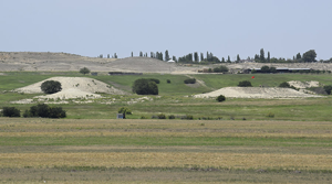
The Səfikürd kurgan complex viewed on the Kite Aerial Picture orthophoto mosaic (map by H. Raese).

Digital Terrain Model of the Səfikürd kurgan complex extrapolated from the Kite Aerial Picture (map by H. Raese).

All collected data were consolidated within a Geographic Information System constructed using ArcMap (v.10.5.1).
Results
Our integrated dataset mapped 100 archaeological sites: 85 kurgans, six necropolises or single tombs dated to the Late Bronze Age/Early Iron Age and nine Chalcolithic (fifth–fourth millennium BC) or medieval (tenth–fifteenth century AD) sites.
Kurgans
Kurgans are the predominant archaeological feature of the area (Figure 5A). The 85 kurgans that we documented are distributed along the entire valley (Figure 1), though they are more concentrated along the northern, lower sector, primarily on the limestone slopes encircling the valley. Thirty-four kurgans are in the alluvial plains. Sixty per cent of the documented kurgans exhibit signs of looting or, at lower elevations, damage resulting from modern human activities.
Examples of: A) a kurgan (WPSF061); B) a necropolis (WPSF072); and C) a Chalcolithic site (site WGS039) (photographs by A. Ricci).

Necropolises
Late Bronze Age/Early Iron Age necropolises (cemeteries) are known in the Tatarli area (Huseynov Reference Huseynov2009). Stones of different sizes were observed in association with Late Bronze Age/Early Iron Age pottery (e.g. Figure 6E) in six locations (e.g. Figure 5B). These are interpreted as necropolises, as similar use of stones is recorded in necropolis contexts from the region.
Examples of pottery sherds recovered during surface collection: A–C) Chalcolithic sherds from site WGP040; D) Kura-Arax sherd from site WGP036; E) Late Bronze Age/Early Iron Age sherd from site WGP038 (figure by authors).

Chalcolithic and medieval sites
The presence of six medieval sites is recorded in both the higher (southern) and lower (northern) sections of the Qaraçay River Valley. Concentrations of pottery over limited areas (50 × 50m) suggest that these sites might represent individual dwellings. A single Early Bronze Age ceramic fragment (Figure 6D) was found among medieval material at site WGP036, approximately 5km south-west of Qaraçinar on the opposite bank of the Qaraçay valley. Chalcolithic pottery (e.g. Figure 6A-C) was also recorded at three sites, one near the village of Tatarli, which was excavated previously (Huseynov Reference Huseynov, Işıklı and Can2015), and two others further south. These are small, mounded sites, less than 100m in diameter and 1–1.5m higher than the surrounding fields. One of them (WGP040; Figure 5C) also had surface scatter of medieval pottery.
Future research perspective
Successful documentation of visible archaeological sites along the Qaraçay River establishes a foundation for forthcoming research initiatives in the region. We plan to expand this study by integrating additional methods of investigation, including geophysical prospections and targeted excavation, within a dedicated research programme. This will include developing strategies to preserve local cultural heritage.
Acknowledgements
We express our gratitude to Fahrad Guliyev and colleagues at the Institute of Archaeology and Anthropology, Azerbaijan National Academy of Science for the support in starting this project, as well as Giulio Palumbi (CNRS Nice) and the members of the 2023 Qaraçinar excavation team for their assistance during the field activities.
Funding statement
This work is funded by the German Research Foundation (DFG) under Germany's Excellence Strategy – EXC 2150–390870439.


 Open access