


Introduction
The settlement at Mokarta is one of the most significant later Bronze Age sites so far discovered in western Sicily. Located on a prominent hilltop range near modern-day Salemi in the Trapani district, the settlement forms part of an area of habitation and mortuary activity that extends across approximately 30ha (Spatafora & Mannino Reference Spatafora, Mannino, Bondi and Cassanelli1992; Mannino & Spatafora Reference Mannino and Spatafora1995; Kolb Reference Kolb and Fitzjohn2007; Nicoletti & Tusa Reference Nicoletti, Tusa and Procelli2012a). The westernmost settlement area, located near the ruins of the medieval Castello di Mokarta, probably covered an area of at least 5ha at the time of its destruction and abandonment at the end of the Bronze Age. While the extent of the settlement has been inferred from the presence of surface artefacts, only a comparatively small part of the site has so far been excavated (Spatafora & Mannino Reference Spatafora, Mannino, Bondi and Cassanelli1992; Tusa & Nicoletti Reference Tusa, Nicoletti and de Vido2000; Nicoletti & Tusa Reference Nicoletti, Tusa and Procelli2012b), revealing circular huts and quadrangular structures with dry-stone wall foundations. Today, the excavated areas and the Castello form an archaeological park, established on the western tip of the plateau after excavations in the 1970s and 1990s. The upslope area adjacent to the excavations and the wider area of the hilltop (including the Cresta di Gallo) are still predominantly private land, protected by applicable heritage laws.
Although previous excavation and survey provide detailed insights into the lives of the Late Bronze Age inhabitants of Mokarta, the extent and layout of the settlement have not been securely established. Mokarta is therefore an ideal candidate for integrated prospection approaches designed to gain further information about the site and provide the basis for re-visiting earlier interpretations.
In this article, Mokarta is placed in the context of known Bronze Age activities within the region, with a focus on settlement activity in and around the designated archaeological park. A combination of geophysical surveys, soil chemistry and interpretation of historical and modern remote-sensing data is integrated with information from previous archaeological investigations to identify further areas of activity surviving below the present-day ground surface, and to tie them to interpretations about settlement structure and functions. These results provide a wealth of new information concerning the extent of the site and the condition of its remains. Furthermore, they demonstrate how a combination of minimally invasive approaches can be used in conjunction with archival material to evaluate the context of an archaeological site affected by a range of post-depositional processes.
Mokarta and the Bronze Age landscape of western Sicily
Mokarta is one of the few well-explored Bronze Age settlement complexes in western Sicily. Indeed, relatively little is known about later Bronze Age human activity in this region, in contrast to other parts of the island. Archaeological data so far suggest that the comparatively homogeneous Middle Bronze Age (Table 1) Thapsos-Milazzese Culture (named after Thapsos in eastern Sicily and Milazzo on the Aeolian Islands) was restructured, resulting in the formation of three distinct cultural groups by the Late Bronze Age.
1. A coastal tradition derived directly from the Thapsos-Milazzese Culture.
2. The Mokarta group, related to the groups known as Pantalica Nord and Cassibile (named after two cemeteries in eastern Sicily).
3. The continental southern Italian Ausonian (Nicoletti & Tusa Reference Nicoletti, Tusa and Procelli2012a: 116).
For the Mokarta group, this societal restructuring is characterised by the development of a distinctive material culture and the establishment of settlements at well-defended locations in Sicily's interior that have commanding views of the surrounding territory and communication routes.
Principal periods and groups mentioned in the text, with their corresponding date ranges (BC/AD).

The site complex
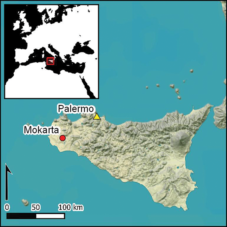
Mokarta lies on a saddle-shaped ridge at the western edge of a series of prominent ridges in the western interior of Sicily, approximately 5km south-east of modern-day Salemi (Figure 1). The toponym Mokarta derives from the name of a figure in Arab-period Sicily purported to have built the Castello di Mokarta located at the western edge of the site. In addition to the protection afforded by the site's location, the distinctive shape and height of the ridge system provides commanding views of the surrounding terrain and key communication routes between Sicily's interior and the coast (Tusa & Nicoletti Reference Tusa, Nicoletti and de Vido2000: 965). Occupation has been identified at two locations on the ridge system, at Cresta di Gallo (not discussed further here) and at the Castello di Mokarta, while more than 60 rock-cut tombs have been documented in the rocky escarpments below these settlements (Spatafora & Mannino Reference Spatafora, Mannino, Bondi and Cassanelli1992; Mannino & Spatafora Reference Mannino and Spatafora1995; Kolb Reference Kolb and Fitzjohn2007: 176) (Figure 2a). Survey and excavation data from across the complex indicate a wide timespan of activity, mainly dating from the Copper Age to the earliest Iron Age (Spatafora & Mannino Reference Spatafora, Mannino, Bondi and Cassanelli1992: 567; Kolb Reference Kolb and Fitzjohn2007; Nicoletti & Tusa Reference Nicoletti, Tusa and Procelli2012b: 905), along with the Arab-period castle complex. While recent work has uncovered evidence of Copper Age structures in lower strata, in situ material from most of the excavated structures point to occupation in the Late/Final Bronze Age (Spatafora & Mannino Reference Spatafora, Mannino, Bondi and Cassanelli1992: 572; Tusa & Nicoletti Reference Tusa, Nicoletti and de Vido2000: 968; Nicoletti & Tusa Reference Nicoletti, Tusa and Procelli2012b) (Figure 2b).
Western Sicily, showing the location of Mokarta and known Late Bronze Age sites (after Nicoletti & Tusa Reference Nicoletti, Tusa and Procelli2012a; background image © ESRI).
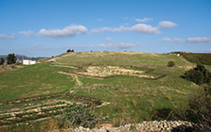
A) The hilly complex at Mokarta, showing mortuary and settlement areas identified by previous surveys and the geophysical survey area. The current area of the archaeological park corresponds to the area of the geophysical survey (modified from Mannino & Spatafora Reference Mannino and Spatafora1995: 12; background image © Google Earth 2017); B) photograph of the settlement area at Castello di Mokarta, looking north-east (photograph by C. Sevara); C) plan of the excavated part of the Castello di Mokarta settlement (from Nicoletti & Tusa Reference Nicoletti, Tusa and Procelli2012b).

The excavated part of the Bronze Age settlement at Castello di Mokarta is characterised by a series of distinctive single-room circular huts with pincer-shaped entrance antechambers (anticella a forcipe; Figure 2c) (Tusa & Nicoletti Reference Tusa, Nicoletti and de Vido2000: 966; Tusa Reference Tusa, Congiu, Micchè and Modeo2009: 30). There is little evidence for such structures at other contemporaneous sites, although traces of circular constructions have been found to the east at Castellazzo di Poggioreale (Trapani), Cannatello (Agrigento) and Sabucina (Caltanissetta) (Falsone et al. Reference Falsone, Leonard, Fresina, Johnson and Fatta1980–1981; Mollo Mezzena Reference Mollo Mezzena, Meli and Cavaleri1993; Fiorentini Reference Fiorentini1993–1994; Tusa Reference Tusa, Congiu, Micchè and Modeo2009: 30; Nicoletti & Tusa Reference Nicoletti, Tusa and Procelli2012a: 120, Reference Nicoletti, Tusa and Procelli2012b: 907). Many of the huts at Castello di Mokarta are connected to quadrangular structures interpreted as workshops or outbuildings (Figure 2c). These structures appear grouped in units of multiple huts surrounded by external walls. Tusa and Nicoletti (Reference Tusa, Nicoletti and de Vido2000: 965) have interpreted this combination of features as a manifestation of a unique western Sicilian culture influenced by both Aegean and local traditions, although the level of Aegean influence has been the subject of more recent debate (Blake Reference Blake2008; Russell Reference Russell2017). By the time of its destruction in the mid tenth century BC, the Mokarta settlement had become a flourishing village, with a complex, organic layout containing distinct structural groups (Nicoletti & Tusa Reference Nicoletti, Tusa and Procelli2012b: 912). Archaeological evidence indicates that the settlement was destroyed in a single catastrophic event, and that it was not intensively reoccupied until after the Iron Age. Most of the excavated huts were apparently set alight, and the quantity and diversity of in situ material in the floor contexts indicate that the inhabitants had no time to evacuate (Tusa & Nicoletti Reference Tusa, Nicoletti and de Vido2000: 966).
Mokarta's environmental context
Today, western Sicily has a Mediterranean climate with hot, dry summers and most rainfall occurring in the mild winter months. Macro-regional palaeoenvironmental data from local lake sediment cores suggest the presence of woodlands during the Mid-Holocene; pollen records indicate an increase in weeds, cultivated crops and herbaceous plants, and a corresponding decline in tree species from c. 600 BC (Tinner et al. Reference Tinner, van Leeuwen, Colombaroli, Vescovi, van der Knaap, Henne, Pasta, D'Angelo and Mantia2009; Calò et al. Reference Calò, Henne, Curry, Magny, Vescovi, La Mantia, Pasta, Vannière and Tinner2012). Wood-charcoal analysis from nearby Monte Polizzo, a site occupied in the mid first millennium BC, suggests that wood was locally sourced at a time, in the Early to Middle Iron Age, when the spread of woodland was at its peak (Stika et al. Reference Stika, Heiss and Zach2008). Ostracod (tiny crustaceans) analysis from lake sediments further suggests that moisture was high during the period of Greek colonisation (c. eighth/seventh to fifth centuries BC) (Curry et al. Reference Curry, Henne, Mesquita-Joanes, Marrone, Pieri, Mantia, Calò and Tinner2016). Mokarta's environmental context at the end of the second millennium BC was probably very different from today, with comparatively abundant local woodland and water resources.
Soils on the Mokarta hill are primarily regosols formed from Early Pliocene clayey and marly limestone and marl formations. Surrounding areas predominantly comprise vertisols and alluvial soils on undifferentiated deposits to the south and on sandy and clayey deposits to the north. The shallow saddle on which the archaeological park is situated provides an outlet for erosion down the steep slopes on its southern side. Although designation of the site as an archaeological park in the early 2000s protected some of the complex, much of the area outside the park remains under agricultural use. The site and adjacent areas of the ridge were planted with vineyards up to the early 2000s, and have been under pasture since the vineyard was removed. The excavations of the circular hut structures at the Castello di Mokarta have demonstrated that modern agriculture had not disturbed in situ floor contexts in that area, even if the site as a whole has been subject to intensive recent land use.
Integrated prospection at Mokarta
Given the environmental context, topographical situation and potential for further evidence of activity at the Castello di Mokarta settlement core, we undertook an integrated prospection survey to gain a clearer picture of the context and condition of buried archaeological features still present at the site. A combination of remote-sensing data evaluation, historical terrain modelling, geophysical prospection, soil coring and geochemistry was used to obtain an overview of the site's subsurface in the vicinity of the archaeological park. Further details of the methods employed are specified in the online supplementary material (OSM).
Historical aerial imagery
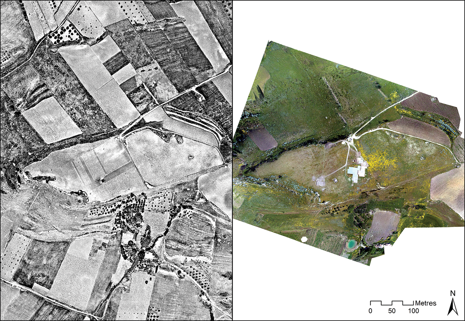
Before conducting the geophysical and soil-sampling surveys, we examined an archive of vertical and oblique aerial images collected over the past 40 years, as well as satellite and land cover data, to gain an understanding of changing land use and to identify additional archaeological features (Doneus Reference Doneus2007; Geoportale Nazionale 2019; Google Earth 2019). The older aerial photographs document the transformation of the regional agricultural landscape at the time vineyards were being planted on the hilltop complex. This change, which occurred just before the 1975 images were taken, seems to have had a major impact on the topography of the settlement complex (Figure 3). Additional putative structures, manifesting as cropmarks to the north of the excavations at the Castello di Mokarta, were identified in a set of images taken in 2004 (Doneus Reference Doneus2007: 280) (Figure 4 top). Although outside the archaeological park, this area falls within the initial boundary of the settlement core as established by surface survey (Mannino & Spatafora Reference Mannino and Spatafora1995: 12).
Vertical orthomosaics of the archaeological park and surrounding area of the Castello di Mokarta settlement: left) photographs taken on 9 May 1975 (courtesy of the Istituto Geografico Militare (image 257-XII-671) with permission, authorization # 7041); right: photographs taken on 2 May 2004 (courtesy of the University of Vienna Aerial Archive).
Top) orthomosaic of 2004 aerial images showing areas interpreted as potential buried structures upslope from the archaeological park (courtesy of the University of Vienna Aerial Archive); bottom) historic DEM surface from 2004, overlain with areas of soil loss (red) and accumulation (blue), as calculated through the subtraction of the 1974 DEM from the 2004 DEM (figure by C. Sevara).

To assess the extent of recent topographical changes, historical imagery was used to extract 3D terrain information corresponding to the dates that the images were taken. Following procedures established in Sevara et al. (Reference Sevara, Verhoeven, Doneus and Draganits2018), historical digital elevation models (hDEMs) with spatial resolution of 0.50 × 0.50m were calculated from the 1975 and 2004 image sets. Our results indicate that, while there appears to be less than 0.50m of change in elevation within the central (unexcavated) part of the archaeological park, erosion at its north-western edge was as much as 0.80m. There was a possible accumulation of soil and debris on the plateau's south-western edge, and over 1m of soil loss in upslope areas to the north-east of the excavations (Figure 4 bottom). Clearly, differential conditions exist across the site, with poorer preservation in some areas likely to affect the survival of archaeological features and hence determine strategies for future investigations as well as potentially influence our interpretation of the site.
Geophysical prospection
Although there is evidence of settlement and mortuary activity at several locations across the hilltop complex, the terms of our permit meant that we concentrated on accessible areas in the archaeological park close to the Castello di Mokarta excavations. The geophysical survey, conducted over seven days in October 2017, consisted of handheld magnetometry (fluxgate gradiometry) and ground-penetrating radar (GPR; details in OSM). Altogether 2.4ha were surveyed. The magnetometry survey results indicate at least 43 anomalies that could be burnt clay or hearths, 23 anomalies that could be clay floors or features that were not heavily burnt, and further contrasting anomalies that could be walls or paths (Figure 5). The GPR survey, conducted over part of the magnetometry survey area, indicate many faint anomalies that correspond to structures identified in the magnetic data (Figure 6). Features and structures identified in the GPR data block appear to be between 0.50 and 1.40m below the modern ground surface.
Top) results of the magnetometry survey, with darker areas indicating higher magnetic values; bottom) interpretation of the anomalies seen in the magnetic data (background images © Google Earth 2016; figure by the authors).
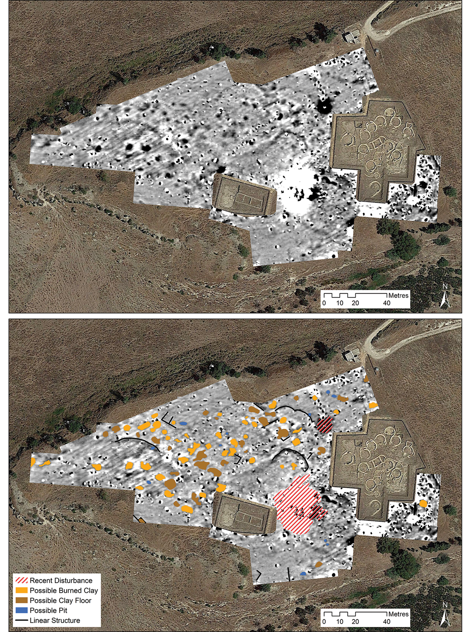
Top) GPR depth slice, 1–1.05m below the ground surface; bottom) interpretation of the anomalies seen in the GPR data (background images © Google Earth 2016; figure by the authors).
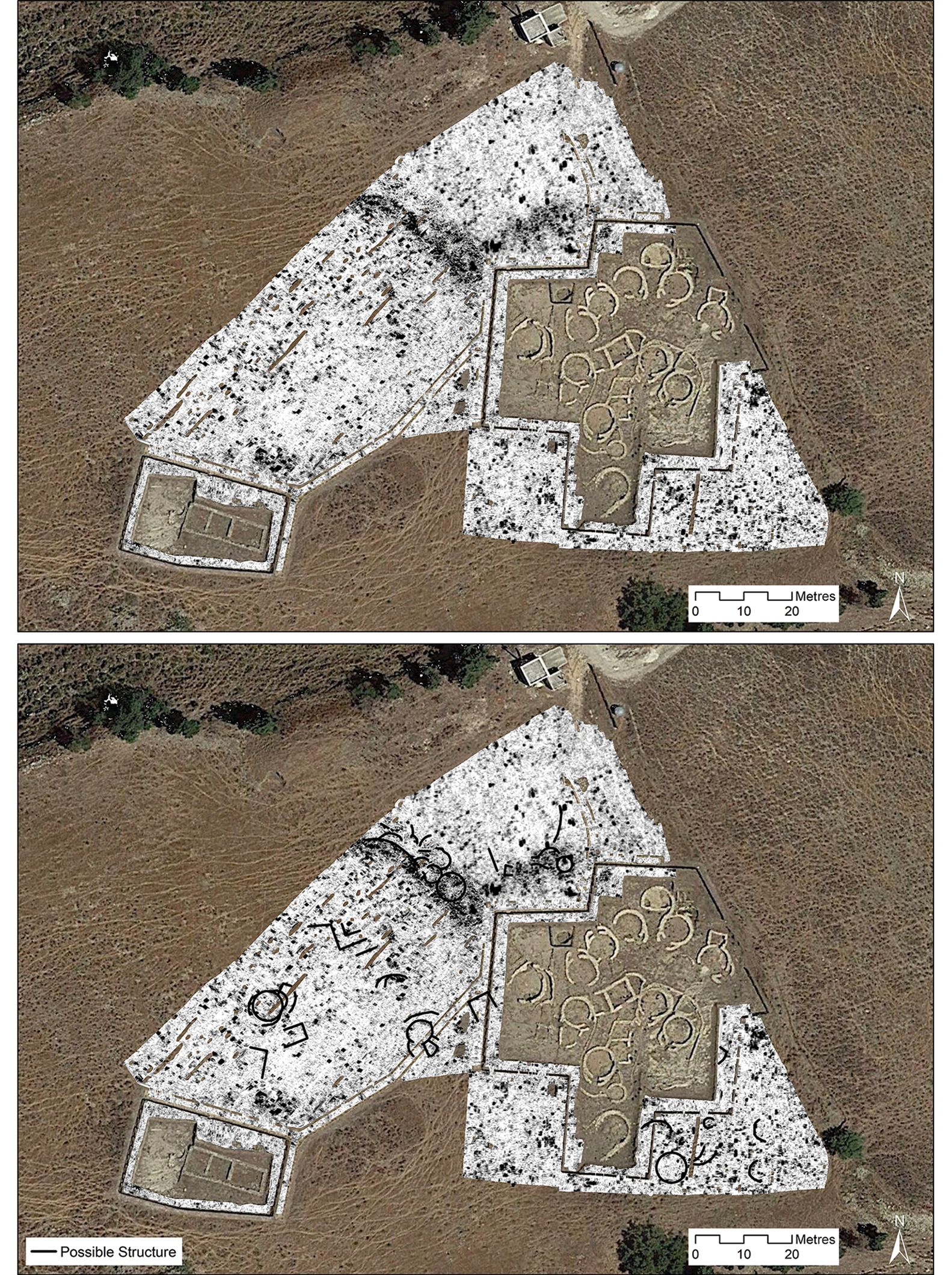
The combined magnetometry and GPR results (Figure 7) suggest that at least 37 additional circular huts with pincer-shaped antechambers, some with associated rectangular outbuildings, are preserved at the site. These huts appear to have interior diameters resembling those previously excavated, ranging between 2.90 and 7.00m, with most between 4.90 and 5.30m (Nicoletti & Tusa Reference Nicoletti, Tusa and Procelli2012b: 906). Several linear features, possibly representing external walls, rectilinear outbuildings or paths comparable to those in the excavated areas, are also visible. Additionally, at least two larger rectangular structures, similar to the structure exposed in the western excavation area, can be seen among the features (Figure 7). It is important to note that the positions of the structures are based on information interpreted from the prospection data, and that we used previously excavated structures as templates for their reconstruction.
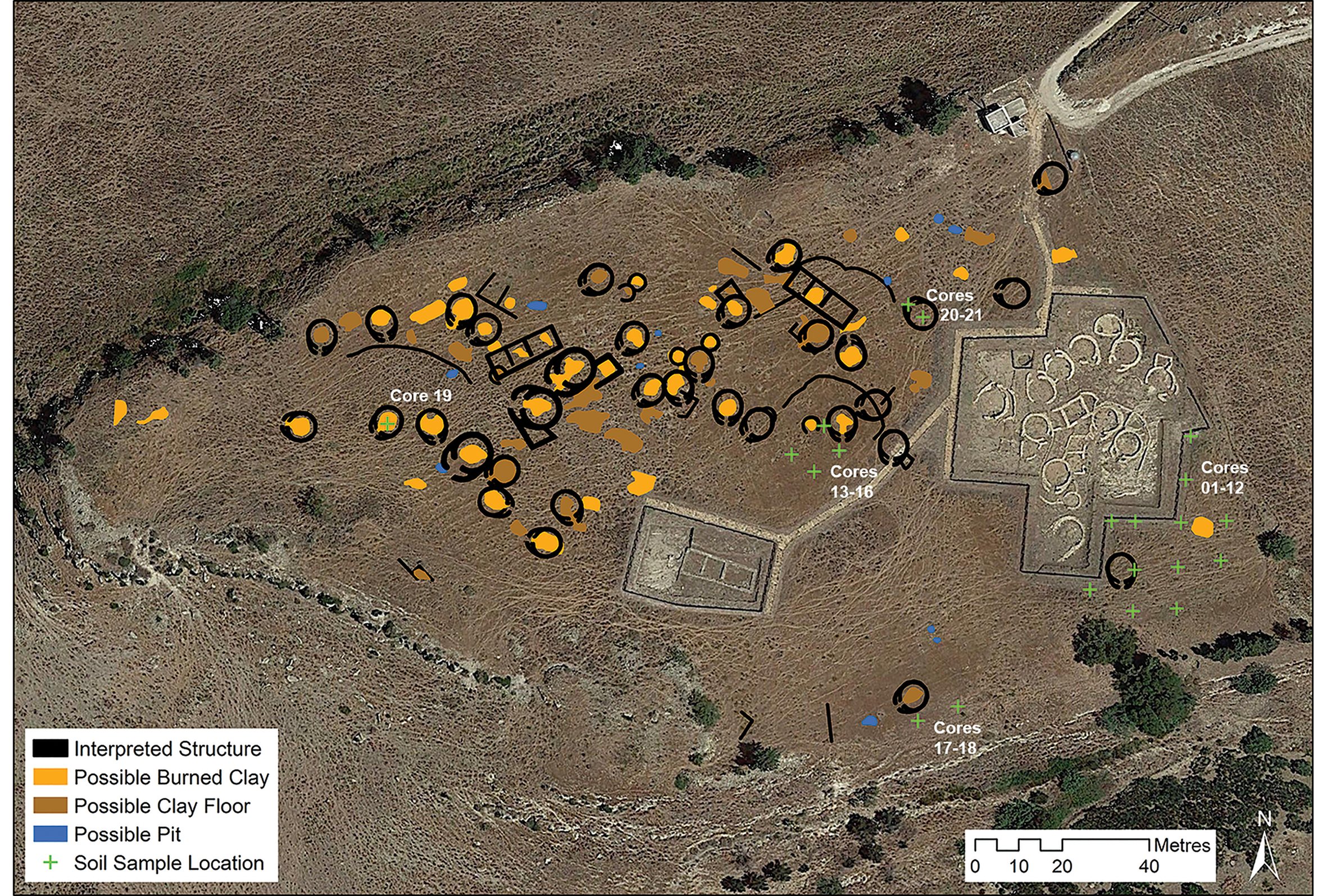
Reconstruction of the settlement layout: combined interpretation of structures and features identified by geophysical survey, showing the locations of cores and excavated areas at Mokarta (background image © Google Earth 2016; figure by the authors).
Soil coring and geochemistry
Soil coring and sampling for archaeological geochemistry was conducted in conjunction with the geophysical survey. Samples were taken from 21 locations (Figure 7). Coring shows that sediments are relatively shallow, brown to reddish-brown, stony, friable silty-loam, sandy-silt and coarse-grained regosols. No well-defined soil horizons or evidence for soil formation was identified. Some colluvial deposits were documented in low areas along the southern side of the site and at the base of the slope at the eastern border of the archaeological park. Most cores contained cultural material in the form of degraded ceramic and charcoal fragments.
Cores 1–12 averaged a depth of 0.33m below the current ground surface, most containing fragments of pottery, burnt clay and charcoal. Cores 13–16 were taken from an ‘open area’ of some 80m2 within the geophysical survey grid (Figure 7) to evaluate stratigraphic integrity and available phosphate (Pav) content. These revealed alternating layers of sediments and soft rock. Cores 17 and 18 were placed on the southern side of the saddle, at the most likely point of drainage. Sediments here were brown to greyish-brown stony, friable silty-loam. Cores 19 and 20 were taken over magnetic and GPR anomalies (respectively) that we interpret as Bronze Age houses. These cores comprise an upper layer of approximately 0.55m of dry, friable, brown, stony silty-loam over a cultural fill extending to a depth approaching 1m. Core 21 was placed 5m to the north-west of core 20 to examine a dark band observed in the GPR data. Rock was reached at a depth of 0.35m.
Thirty-five samples of approximately 100g were taken from the cores and analysed for phosphates (Pav), pH and carbonates. Soil pH averaged 6.65. Pav was consistently high across the site, with very little horizontal or vertical variability. Typically, high Pav values at settlements are taken as evidence for the deposition of organic content associated with agricultural and subsistence activities (Holliday & Gartner Reference Holliday and Gartner2007; Salisbury Reference Salisbury2012).
Discussion: new discoveries at Mokarta
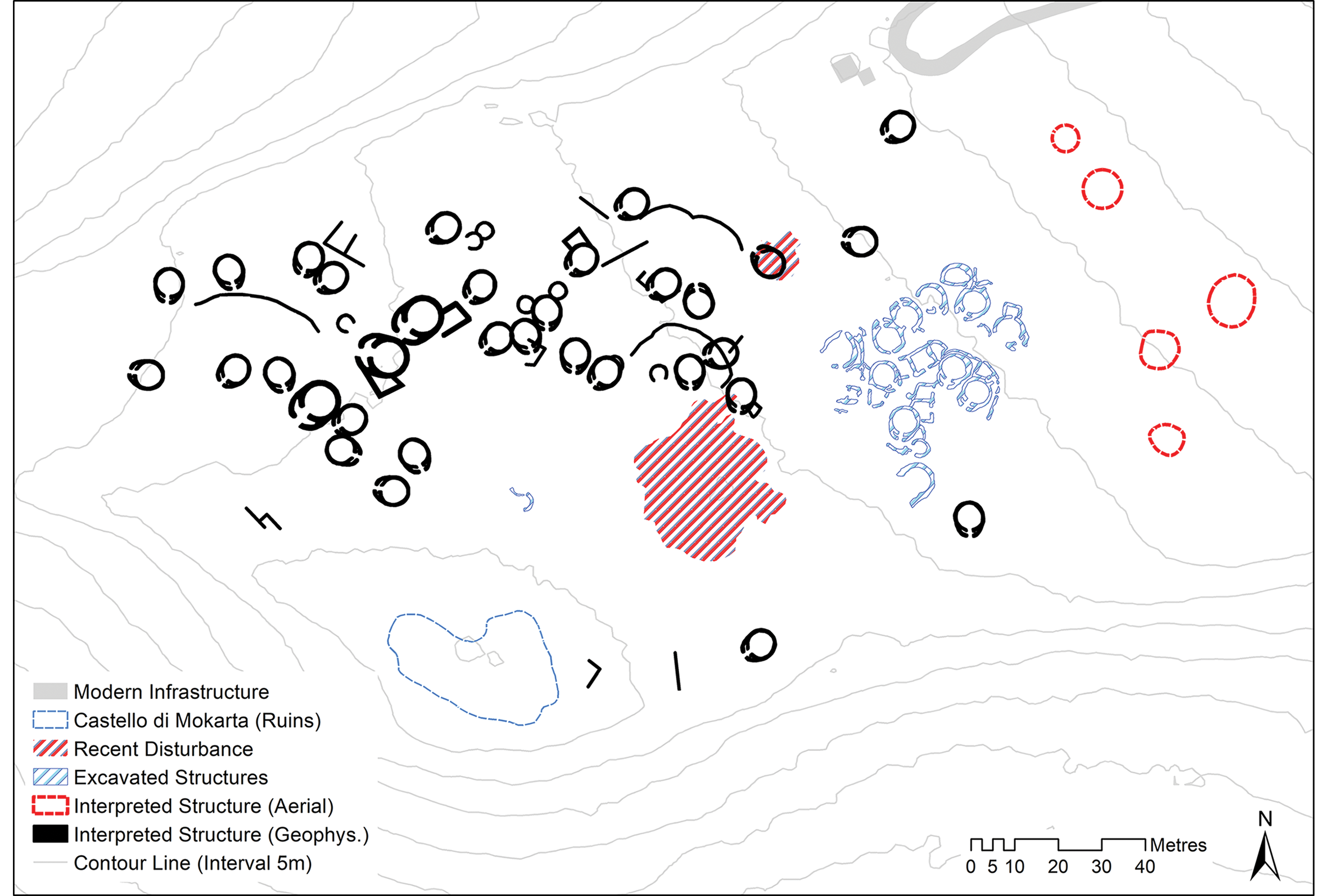
Our results provide new and comprehensive information concerning the presence of nearly 40 previously undocumented structures in and around the archaeological park at Mokarta. In combination with data from previous excavations, this gives insights into the Bronze Age settlement, which we can now reconstruct over a much larger area (Figure 8). The spatial distribution and depths of the structures appear to follow those of the excavated area, indicating a mixture of circular and rectangular buildings of non-uniform size and orientation, clustered in groups, and demarcated by paths and boundary walls. Like the excavated examples, huts in our interpretation are oriented in several directions; none, however, have openings aligned toward the north-east/upslope area. These observations suggest that many of the structures detected in the survey are contemporaneous with those in the excavated part of the settlement.
Reconstruction of the possible location and position of Late Bronze Age structures at Mokarta, indicating those found during excavation (in blue), geophysical prospection (in black) and during aerial reconnaissance (in red) (figure by C. Sevara).
The presence of further structures gives an idea of the size of Mokarta's former population and supports the notion that it may have played a role as a central place in the region. If, as suggested by previous excavations, the differences in the structures’ architecture can be linked to an evolution in the use of space (Tusa Reference Tusa, Congiu, Micchè and Modeo2009: 30), the addition of further rectangular outbuildings, considered to be a later development, could indicate that a more formalised division of space took place within the settlement, possibly because the inhabitants of Mokarta were producing and storing greater quantities of goods and foodstuffs, and that activity zones within the settlement were becoming more concentrated.
At Mokarta, we have the advantage of being able to integrate excavation data into the interpretation of our survey data, which can help us to interpret the potential causes and functions of the detected anomalies. The magnetic data indicate a combination of burnt features and unburnt clay surfaces in and around the putative hut structures (Figure 7), suggesting that a central hearth, unburnt floor areas or collapsed clay-based building material were present inside the huts, as attested by previous excavations (Tusa & Nicoletti Reference Tusa, Nicoletti and de Vido2000: 969). The presence of ceramic and charcoal in soil cores also supports this interpretation. Evidence from the excavated areas indicates that the structures burned at a very high temperature, then perhaps cooled before collapsing, as excavated floor layers show little sign of burning (Tusa & Nicoletti Reference Tusa, Nicoletti and de Vido2000: 971). This scenario could explain the non-uniform distribution of magnetic values across the presumed floor surfaces (Figure 5). The signatures of other buried features, deduced from the distribution of assemblages potentially in situ, suggest that the destruction of the site was not limited to the centrally excavated sector. Our survey evidence therefore supports the interpretation of a catastrophic event ending the Bronze Age occupation at the site. This contributes to the narrative of the sudden abandonment of a settlement of significant size in the region (Tusa Reference Tusa, Congiu, Micchè and Modeo2009; Nicoletti & Tusa Reference Nicoletti, Tusa and Procelli2012b: 913) during a period of potential local instability and regional reorganisation.
Soil phosphate survey across the site failed to provide clear information about Mokarta's Bronze Age occupation. Although soil samples showed elevated Pav values, the stony soil in most areas made it impossible for coring to reach the expected depth of Bronze Age levels; it is likely that the results from soil sampling represent the overlying soils and plough soils. The mixed, stony soil is unlikely to have been caused by natural pedogenic processes since the Bronze Age. Rather, sediments indicate extensive surface and subsurface disturbance to a depth of approximately 0.45–0.50m, a process that may, in areas of shallower deposits, have mixed Bronze Age surface layers with more recent topsoil. There are several possible explanations for the consistently high Pav values observed across the site, including overlapping Bronze Age activity zones, the deposition of organic matter during the medieval occupation of the castle, organically enriched deposits eroding from upslope, regular grazing and fertilisation by sheep in recent decades, or some combination of these processes.
Cores taken over geophysical anomalies were more successful, revealing deep anthropogenic deposits. The high Pav values of these deposits supports the hypothesis that Bronze Age soils at the site are mixed with modern topsoil and soils eroding from upslope. While these results help with the interpretation of the conditions prevailing at the site overall, they suggest that further soil phosphate survey is unlikely to add to our knowledge of site activities. Nevertheless, any future excavations should include multi-element chemical analysis of samples from archaeological surfaces or features to enhance the interpretation of activities in and around the houses.
Understanding Mokarta's context and state of preservation
Our survey results support earlier inferences that the area around the archaeological park at Mokarta contains a large and complex Late Bronze Age settlement. Previous aerial and surface surveys indicate that the settlement spreads well beyond the current archaeological park, probably spanning a period extending beyond the Late/Final Bronze Age (Spatafora & Mannino Reference Spatafora, Mannino, Bondi and Cassanelli1992: Mannino & Spatafora Reference Mannino and Spatafora1995: 12; Doneus Reference Doneus2007: 279; Kolb Reference Kolb and Fitzjohn2007). Material recovered from the adjacent ploughed field also supports this inference. We therefore predict that the settlement at Castello di Mokarta extends upslope of the archaeological park. We also expect to recover additional information about the settlement if permission to survey outside the archaeological park can be obtained. A sampling strategy that includes soil chemistry, absolute dating and subsurface magnetic susceptibility measurements should allow us to assess more fully the extent, context and conditions of subsurface remains at Mokarta (e.g. Dalan et al. Reference Dalan, Sturdevant, Wallace, Schneider and Vore2017; Kainz & Cotter Reference Kainz and Cotter2018). In addition to establishing the spatial layout, these approaches could be used to address further questions related to potential differential uses of the circular and rectangular structures (e.g. dwellings, storage or animal enclosures), different zones of activity, the abandonment of the site and the effects of post-depositional processes on site preservation.
Our geophysical prospection survey also indicates the high probability of subsurface preservation in some areas, with the possibility of in situ contexts similar to those found in previous excavations. GPR data and coring of geophysical anomalies suggest that cultural deposits still exist in some areas, even though the analysis of soil movement from historic DEMs reveals a significant amount of soil loss between 1975 and 2004, mainly in the area upslope of the archaeological park. It seems clear that differential conditions of preservation exist on site, with better preservation in the centre of the park and more disturbed deposits to the east. Future prospection should therefore concentrate on areas where modern activities may be having a more detrimental effect on site preservation.
An expanded view of Mokarta's significance
This study contributes to defining a regionally significant, spatially complex settlement at the end of the Bronze Age. The newly revealed aspects of Mokarta's structure and organisation suggest that the site's spatial development contrasts with large sites in other parts of Sicily, where rectilinear buildings begin to predominate after the Middle Bronze Age. Our reconstruction of circular huts identified by survey shows evidence of pincer-shaped antechambers that have yet to be found in significant numbers elsewhere in the region. The circular structures at Cannatello seem to bear the greatest resemblance to Mokarta's architectural layout (Fiorentini Reference Fiorentini1993–1994: 719). This includes a single hut, occupied earlier (in the Middle Bronze Age), much larger in diameter, but with a similar antechamber (hut 2; de Miro Reference de Miro, La Rosa, Palermo and Vagnetti1999: 440). Although assemblages found at the two sites suggest connections with different parts of the Mediterranean at different times, their architectural similarities could indicate that both sites were built by ‘local’ populations (Russell Reference Russell2017: 73).
The circular structure is often cited as an indigenous marker in Sicilian architectural development, rooted in earlier periods and serving as a reference point for cultural continuity in later periods (e.g. Hodos Reference Hodos2010: 17). Hence we propose that Mokarta shows continuity with indigenous customs rather than external influence. Based on such arguments, our interpretations would indicate that the building style remained strongly influenced by earlier architectural traditions, unlike the evolution observed on eastern sites, such as Thapsos (itself a rather unique site in Sicily), where there is a shift in planning and the use of space based on the introduction of rectilinear central courtyard buildings. As very few large Late Bronze Age settlements have been investigated in detail in western Sicily, and given the uneven nature of the data available, our view of this period and meaningful regional interpretations concerning social organisation are limited (e.g. Leighton Reference Leighton2005: 282). This makes it difficult to use the new information gathered at Mokarta to understand more widely the cultural continuity, regional population development and transitional events during the second millennium BC. Hence, attempts to reconcile Mokarta's building style with its cultural significance and connections to other activity in the region should proceed with caution.
Given what has been proposed about Mokarta's environmental context in the later Bronze Age, we expect that local resources were more than sufficient to support a large, centralised population engaged in agropastoral pursuits. Arguments for the development of larger inland Late Bronze Age settlement areas such as Mokarta, traditionally oriented towards defensibility and the control of terrain, could now also include the development of complex agricultural exploitation in fertile inland areas. Architectural developments, such as outbuildings for storage, could be a reason for, or reaction to, such a situation, but this too depends on achieving a better understanding of site contexts, settlement patterns, environmental conditions and infrastructure development in the region. Preliminary survey results indicate sparse occupation in the territory around Mokarta during the Late Bronze Age, but it is nonetheless possible that areas adjacent to the settlement were cultivated (Kolb Reference Kolb and Fitzjohn2007: 177). Our work at Mokarta suggests that a suite of integrated prospection approaches can provide an efficient method to collect further information about the wider landscape around the settlement.
Conclusion
Geophysical prospection, coring, analysis of archival information and comparison with extant archaeological data show that settlement activity at Mokarta was far more extensive and complex than previously documented, although it had already been suspected, largely from the presence of surface finds. The layout of the newly detected structures appears consistent with excavated parts of the site and narratives of its abandonment. In particular, a better understanding of the size and complexity of Mokarta reinforces the interpretation of the site as a central place in the Late Bronze Age landscape of western Sicily. Furthermore, the presence of Neolithic to Arab-period material in and around the settlement suggests that the focus of analysis can now be broadened to include further information about the diachronic development of the cultural landscape.
While Bronze Age Mokarta continues to be regarded as one of the most important settlements in western Sicily, a lack of comparative information about other settlements limits new interpretations of the wider cultural landscape at the end of the second millennium BC. Using a suite of minimally invasive approaches at other sites in the region, extending outwards from the central parts of sites to their surrounding landscape, can provide a new level of information about past cultural and environmental activities, enabling us to refine our interpretations of human activities in a period in which sociocultural developments are still poorly understood.
Our work at Mokarta can be more generally useful from several perspectives. On an interpretive level, an expanded view of the settlement offers insight into its establishment, layout, development, specific events and abandonment. From a site-management standpoint, assessing the current conditions and the impact of post-depositional processes helps develop comprehensive strategies for future work and conservation. This can be applied in a minimally invasive way to sites undergoing similar post-depositional processes, incorporating available archaeological and remote-sensing information to contribute to our understanding of past human and environmental activities.
Acknowledgements
We dedicate this article to the memory of our friend and colleague Sebastiano Tusa, without whom this research would not have been possible. The ‘Prospecting Boundaries’ project (http://mazaro.univie.ac.at) is funded by the Austrian Science Fund (project ID: P-28410) and carried out in cooperation with the Soprintendenza per i Beni culturali ed ambientali di Trapani. Part of this research was also undertaken while Christopher Sevara was a visiting scholar at Stanford University's Department of Classics. We thank the Istituto Geografico Militare (http://www.igmi.org) for permission to use its imagery here (authorisation 7041). We also thank the anonymous reviewers for their input on earlier drafts of this paper.
Christopher Sevara developed the paper framework, wrote the bulk of the text, conducted the aerial imagery analysis and created the figures. Roderick Salisbury conducted the coring and soil-chemistry analysis, wrote the bulk of the environmental background, edited and revised the manuscript, and made significant contributions to the discussion and conclusion sections. Ralf Totschnig and Klaus Löcker conducted the geophysical prospection and initial interpretation of prospection data. Michael Doneus contributed to the aerial imagery analysis, the discussion and conclusion sections, and to the revision and editing of the manuscript. Sebastiano Tusa arranged for fieldwork to take place and contributed to the archaeological background and interpretation.
Supplementary material
To view supplementary material for this article, please visit https://doi.org/10.15184/aqy.2019.171.


 Open access