Introduction
Glaciar Pio XI (49°12ʹ S, 74°03ʹ W) flows west from Hielo Patagónico Sur (southern Patagonia ice field) from a maximum elevation of 3380 m (Volcán Lautaro) down to sea level (Eyre Fjord) (Fig. 1). The glacier is 64 km long with a surface of 1275 km2 ..., and is the largest glacier in South America (Aniya and others, in press).
The historical and recent fluctuations of Glaciar Pio XI have been analyzed by different authors (Rivera, 1992; Warren and Sugden, 1993; Warren and Rivera, 1994; Warren and others, 1997). Models presented by these authors for explaining the advance include fjord topography, sediment budget, calving dynamics and climate. However, the present lack of glaciological and climatological data obstructs attempts to obtain a better understanding of the behaviour of the glacier and its causes.
In this paper, velocity and meteorological field data collected during November 1995 are presented. The data are used in combination with historical climate records and glacier front positions interpret the anomalous advance of Glaciar Pio XI.
Also, cross-sections and increment cores from Pilgerodendron uviferum tree trunks at the margin of Glaciar Pio XI were collected in 1995. Preliminary analysis of the tree rings indicates a maximum age of over 400 years, and the data show good potential for dendroclimatological correlation. Detailed results will be presented elsewhere.
Methodology
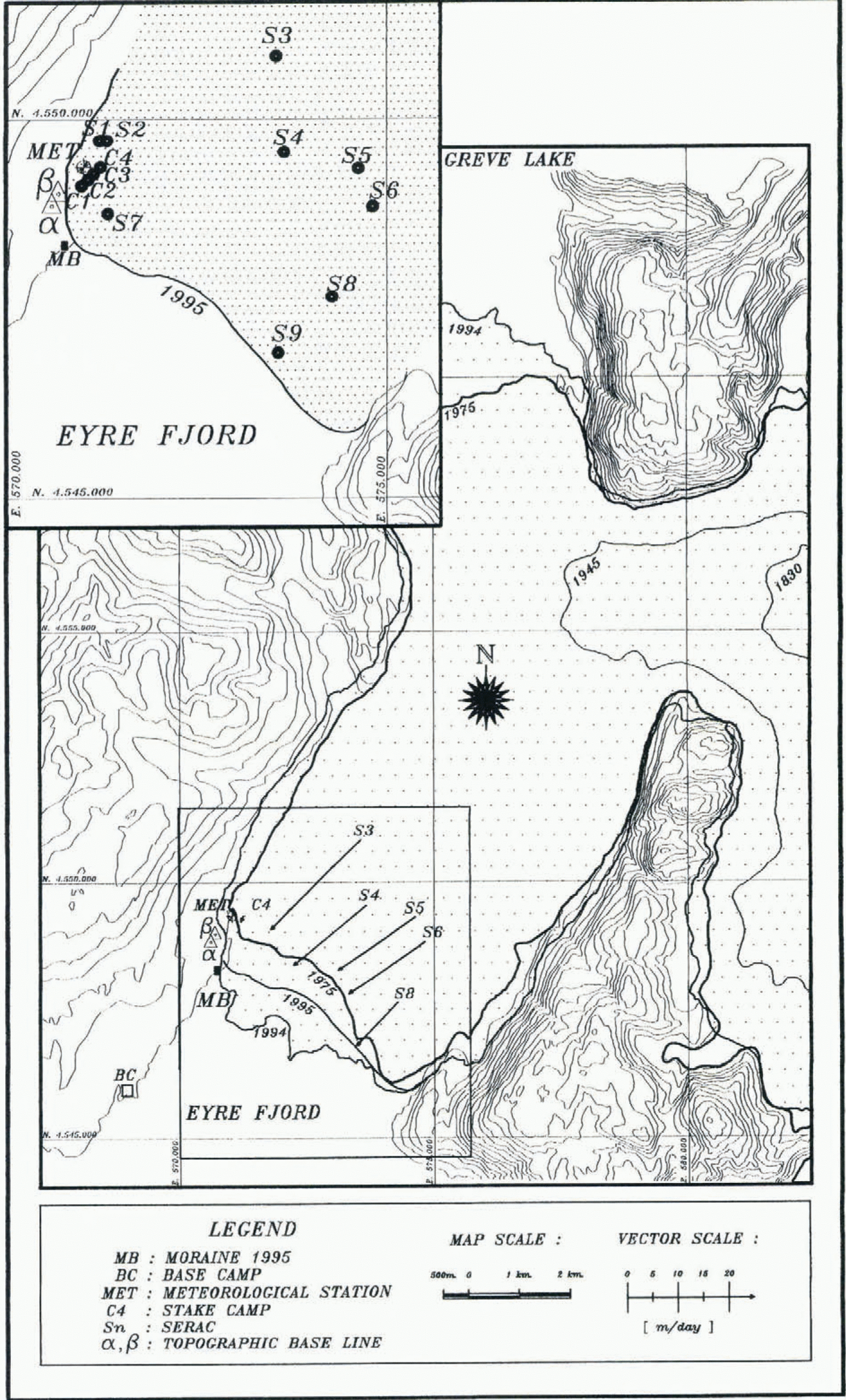
Because of the unusually large amount of icebergs that blocked Eyre Fjord in November 1995, base camp could only be installed 3.5 km from the front of the glacier, along the western margin (Fig. 2).
Meteorology
An automatic weather station with digital recording (TAMMS), powered by 12 V batteries, was installed on the ice, 295 m from the glacier margin and 1057 m from the front of the southern tongue, at 102 m elevation. Sensors included temperature, humidity, atmospheric pressure, wind speed and direction. The sensors were placed 2 m above the clean-ice surface, and were calibrated with portable instruments in situ. Due to battery problems, only partial data records were obtained for the period 10–24 November.
Topographic survey
A 179 m baseline was set up on a hill above base camp, from where the position of four stakes near the western margin (C1–C4), and 11 prominent seracs on the centre and close to the eastern margin of the glacier (S1–S11) were measured using a Wild TC 1600 digital theodolite (Fig. 2). Measurements were repeated at different time intervals, from which speed data could be obtained. The position of the glacier front was measured from the same baseline, and auxiliary points obtained by topographic traverse measurements.
The uncertainties of horizontal and vertical angle measurements are estimated to be 5ʺ, including uncertainties in serac identification. The baseline distance was measured with a precision of 5 mm. This results in an uncertainty of 2.5 m in the along-flow position of serac S3, which is the most unfavourable case of all measurements, due to the slanting angle involved (Fig. 2). Thus, the uncertainty in speed for a 1d period at S3 is 3.5 md, or 7–22% of the measured speed at S3. For the rest of the seracs, speed uncertainties are estimated to be less than 15%.
Climatology
Rainfall series along the coast of southern Chile were analyzed by Rosenblüth and others (1995), defining a significant variability of the series with latitude.
location of Glaciar Pio XI. San Pedro and Cabo Raper are two meteorological stations mentioned in the text.
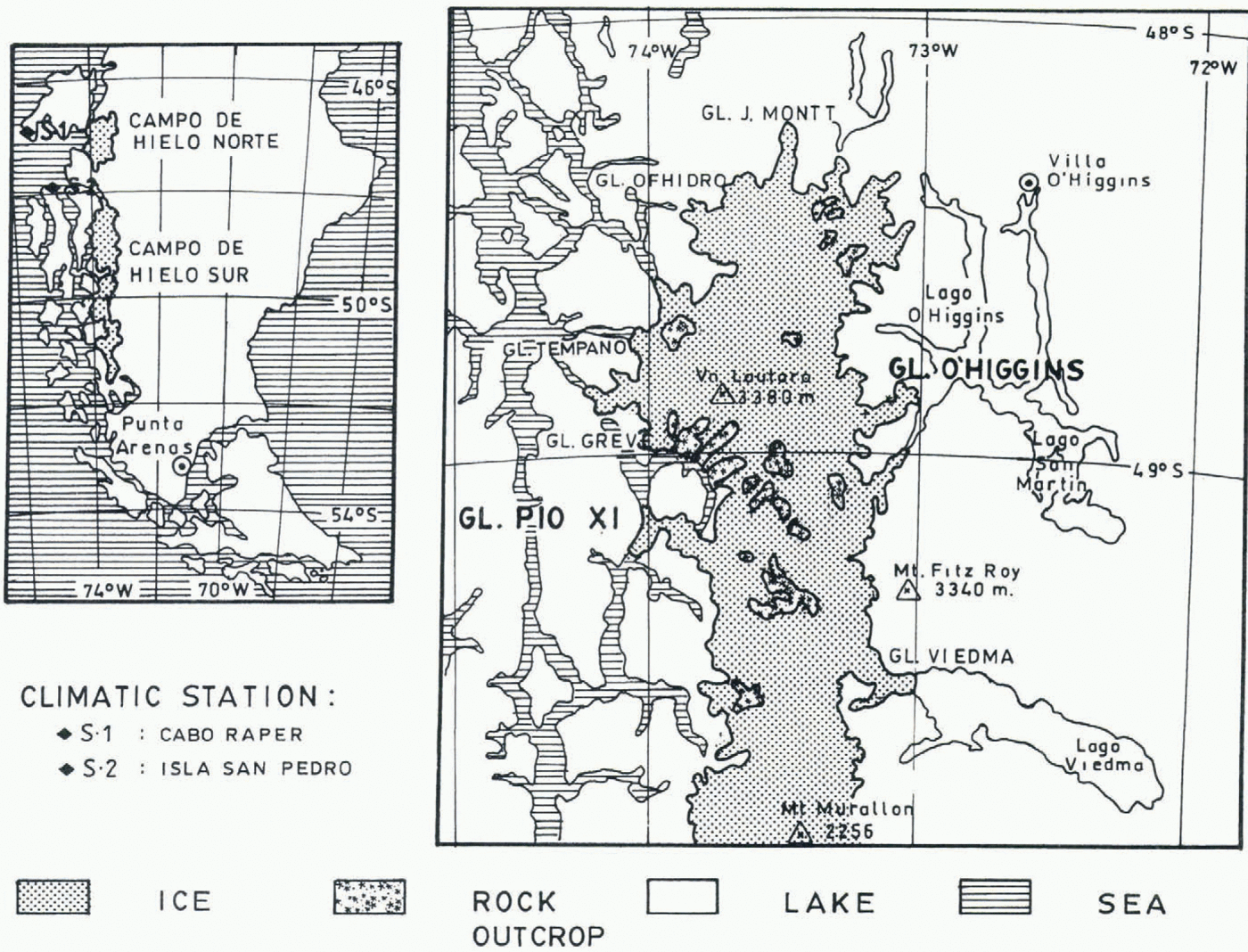
The two closest stations to Glaciar Pio XI are San Pedro (47°43ʹ S, 74°55ʹ W) and Cabo Raper (46°50ʹ S, 75°35ʹ W), both located at sea level (Fig. 1). Precipitation records of these two stations were not analyzed by Rosenblüth and others, but are regarded as representative of the glacier. They present similar interannual trends, as analyzed with 3 year running means as well as normalization of monthly anomalies.
Position of the glacier front
A historical record of glacier front positions has been compiled by Warren and Rivera (1994) and Warren and others (1997). This record was complemented by the frontal position in October 1994 obtained from a SIR-C/X-SAR image (Forster and others, In press), and the position in November 1995 obtained from field measurements.
Results
Short-term speed variations
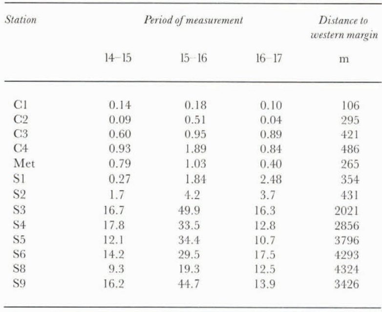
Ice speeds obtained from repealed survey of stakes and seracs (Fig. 2) show large spatial and short-term variations during the period 14–17 November (table 1).
At S3, a daily speed of 16–50 m d−1 was observed. Even though S3 is located closer to the western margin of the glacier than to the renter line, speeds are maximum at this particular cross-section of the glacier. This may be due to a westward deflection of ice flux as the main body of the glacier is forced to turn around the “peninsula” located upstream along the eastern margin, splitting the ice flow into two tongues, the northern one calving at Greve lake and the southern tongue calving into Eyre Fjord, both of which are oriented at near 90° with respect to the incoming ice flow.
Ice speed data (m d−1), November 1995
Topographic map of Glaciar Pio XI, showing the positions at different epochs. Vectors indicate mean ice velocities measured by surveying serac positions during four 1 d intervals in November 1995. Coordinates are expressed in UTM units. Adapted from Instituto Geografico Militar map at 1: 50 000 scale.
At S3, composed of clean ice, there is a local topographic depression across-flow on the surface, with prominent crevasses oriented along-flow. Both the depression and the crevasses, together with the high speeds measured, suggest the existence of a “flow stripe” at S3, typical of “streaming flow” and areas of high shear, as found on polar glaciers (Casassa and Brecher, 1993). In fact, shear strain rates here are high: 0.02 m d−1 between S3 (average speed 27.6 m d−1) and C4 (average speed 1.2 m d−1).
In contrast, toward the western margin, from C4 to C1, the ice flows much more slowly, with an average speed of 0.14 m d−1 at C1, resulting in a shear strain rate of 0.003 m d−1. Consistent with the lateral shear, the ice in this region presents typical splaying crevasses. The ice here has a small amount of debris, presumably upthrusted from internal and basal moraine bands.
East of S3, toward the center of the glacier, ice speeds at S4, S5 and S6 varied between 10.7 and 33.5 m d−1 for the period. Near the eastern margin, at S8 and S9, iee speed varied between 9.3 and 44.7 m d−1 for the same period (table 1).
Temperature data measured at the meteorological station near C2 show that minimum temperatures for the period 11–24 November, are relatively stable, above 2°C, and occur between 0400 and 0500 h local time. Maximum temperatures vary between 7°C for overcast days and 13°C for clear days, and occur around 1800 h local time. This results in mean daily temperatures of 4–6°C for the period.
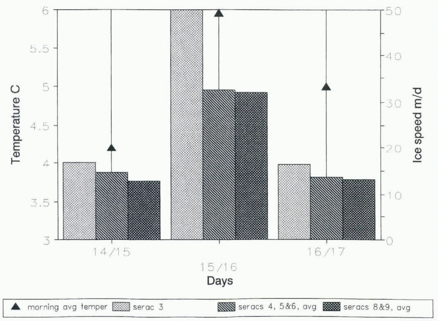
Changes in basal sliding, which depends largely on the amount of water in the glacial system, arc thought to be responsible for short-term changes in surface velocity (Naruse and others, 1992). No precipitation occurred during the period 14–17 November, and high radiation and temperature rates were observed during 15–16 November, with clear weather, resulting in maximum ablation for this 24 h period. Therefore, the amount of subglacial water can be assumed to depend mainly on air temperatures during the 3 d period. Maximum ice speeds occurred during the cleat-days (15–16 November), particularly in the morning, with a lag time of about 12 h with respect to the peak in ablation (Fig. 3).
Multi-annual variations of the glacier front
1993–95 In November 1995, the position of the glacier front was 200–250 m south of the 1993 position. About 50 m south of the frontal position of the glacier in 1995, a recent lateral push-moraine was found. This moraine, not present at the time of a field expedition in 1993 (Warren and others, 1997), is 100 m long and 2530 m high. A large outlet stream, draining a forested valley located on the western margin of the glacier, was found in November 1995 beside the lateral moraine. Strong erosion was evident along the stream, indicating that it acted as a spillway when the forested valley was dammed by the advance of Glaciar Pio XI.
The moraine, the spillway and a marked trim line surrounding the glacier, located 30–50 m above the ice surface in November 1995, indicate that the glacier attained a maximum position between November 1993 and November 1995.
In fact, a SIR-C image of October 1994 shows the glacier front to be in a maximum position for the period 1993–95, 600–1000 m south of the position in November 1995. This results in an advance of 0.8–1.25 km of the southern front of Glaciar Pio XI for the period November 1993–October 1994, with a subsequent retreat of 0.6–1.0 km for the period October 1994 November 1995.
Surface area loss in 12 months between 1994 and 1995 was 2.3 km2 .... This ice mass was most probably lost by enhanced calving, evidence of which is the unusual number of icebergs at the glacier front in November 1995, which prevented a close approach by boat.
Glacier variations during the 20th century and correlation with precipitation During the 20th century Glaciar Pio XI has presented four strong advance periods (Rivera, 1992, and present observations): 1926–28; 1945–51; 1976–81; s1992–94.
The following characteristies can be pointed out by comparing the above advance periods with the precipitation anomaly series of San Pedro and Cabo Raper stations from 1914 to 1984 (Fig. 4):
A 22 year cycle with positive anomalies and a maximum in 1937,14 years before the advance of 1945–51.
A 12 year cycle of positive anomalies from 1972 until 1984, with a maximum in 1981, 11 years before the advance detected during 1992–94.
The advance of 1976–81 could have been in response to the last phase of the positive rainfall anomalies recorded during 1932–55, 1955 being the year with highest precipitation (Fig. 4). However, this advance occurs 12–14 years after a minimum precipitation anomaly, which suggests that either the response time period is longer, or there is simply no correlation of frontal advance with precipitation.
Mean ice speeds averaged during three 24 h periods vs average morning temperature (0000–1200 h) measured at the meteorological station on the glacier. The maximum ice speed measured during 15–16 November correlates well with the high temperature recorded that day. Ablation was maximum during 15–16 November No rainfall occurred during the period. Morning temperature was selected because data is missing at other times of the day due to battery problems in the field.

Rainfall series constructed from the average of San Pedro and Cabo Raper stations, vs relative position of the southern glacier front. Vertical bars indicate advances (>0) and retreats (<0), in km.
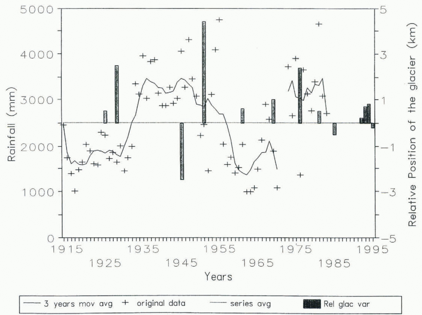
If the above correlation of glacier front advances with positive precipitation anomalies is valid, the advance of 1926–28 presumably occurred in response to a precipitation maximum before 1914, when no data exist for the stations of San Pedro and Cabo Raper.
In summary, while the correlation of frontal advance with positive precipitation anomaly is not clear, it could suggest a glacier response time of 10–15 years. The only exception is the advance of 1976–81, which would indicate a longer response time of 20–25 years.
Discussion and Conclusions
Surging glacier?
The maximum ice velocities obtained from measurements of serac positions every 24 h ranged from 17 to 50 m d−1 at S3. The high ice speeds could be regarded as surging speeds in normal-flowing glaciers. However, we know that the southern front of Glaciar Pio XI was retreating in November 1995. Also, the historical record of glacier position during the past 70 years (Fig. 4) shows that, except for a strong retreat around 1945 and a smaller one in 1980, the glacier has been advancing during most of the period. At least since 1975, the glacier has been in a relatively stable position, which suggests a regime not significantly different from equilibrium. Thus, rather than surging, the glacier seems to have adapted to new dynamic conditions during the past 20 years. Whether the dynamics are governed by calving, fjord topography, sediment budget, climate, volcanic activity or a combination of these causes is still unknown.
Even though the 1993–94 advance was relatively large, as evidenced by the formation of the 25–30 m high moraine described earlier, no significant area gain of the southern front could be measured, as opposed to the advances which occurred in the 1920s, 1950s and 1970s. An explanation for the lack of area gain is that the glacier is reaching deeper waters in Eyre Fjord, resulting in enhanced calving which restricts any frontal advance. Once the basin is partly filled with glacial sediments, the glacier will have a shallower bed, with reduced calving and increased frontal advance (Warren and Rivera, 1994).
Acknowledgements
This work has been funded mainly through Project FON-DECYT 1950722. Travel support for A.R. was received from the Departamento Técnico de Investigación (DTI) of Universidad de Chile. The radar image of 1994 was obtained from E. Rignot at the Jet Propulsion Laboratory, California Institute of Technology, Pasadena, and R. Forster at Cornell University, Ithaca, New York. Map digitizing was performed by P. Salazar, and the cartography was compiled by R. Smith. The Swedish Project Sarec “Climatic Change During the Holocene” supported one of the authors (J.C.A.). J. Quinteros gave constant assistance in the field.