





Introduction
The North American Southwest is characterised by a large number of well-preserved ancient Pueblo settlements and rock art sites. Today, this region is still inhabited by descendants of Ancestral Puebloans who, despite hundreds of years of contact with Euro-American culture, have successfully preserved many traditions, beliefs and customs, passed down through the generations, thus preserving much information about past beliefs, symbolism and history (Cordell Reference Cordell1997; Plog Reference Plog1997; Lipe & Varien Reference Lipe, Varien, Lipe, Varien and Wilshusen1999).
The central Mesa Verde region in the North American Southwest is located in present-day south-eastern Utah and south-western Colorado. For over 1500 years, this region was home to many farming Puebloan societies. In the thirteenth century AD, however, these settlements relocated from the plateaus (mesas) to the edges and slopes of canyons, and to cliff alcoves, most probably for defensive reasons; by the end of that century, the region had witnessed complete depopulation and migration to other areas. Several explanations have been proposed for this depopulation, including increasing conflicts and violence; climatic changes, such as the Great Drought of AD 1276–1299; the beginning of the Little Ice Age in the Northern Hemisphere; and unpredictable precipitation in the Mesa Verde region. Additionally, local environmental changes, such as a decrease in the number of permanent water sources, were probably at least partly coincident with anthropogenic deforestation and depletion of natural resources. Social changes and the attraction of new cults or ideologies may also have been contributing factors (e.g. Lipe Reference Lipe1995; Lipe & Varien Reference Lipe, Varien, Lipe, Varien and Wilshusen1999; Dean & Van West Reference Dean, West, Varien and Wilshusen2002; Cameron Reference Cameron and Noble2006; Kohler et al. Reference Kohler, Varien and Wright2010; Schwindt et al. Reference Schwindt, Bocinsky, Ortman, Glowacki, Varien and Kohler2016). It is unlikely, however, that any of these theories alone can fully explain the total depopulation of the region. Rather, it is more probable that some combination of these and other factors contributed to the migration.
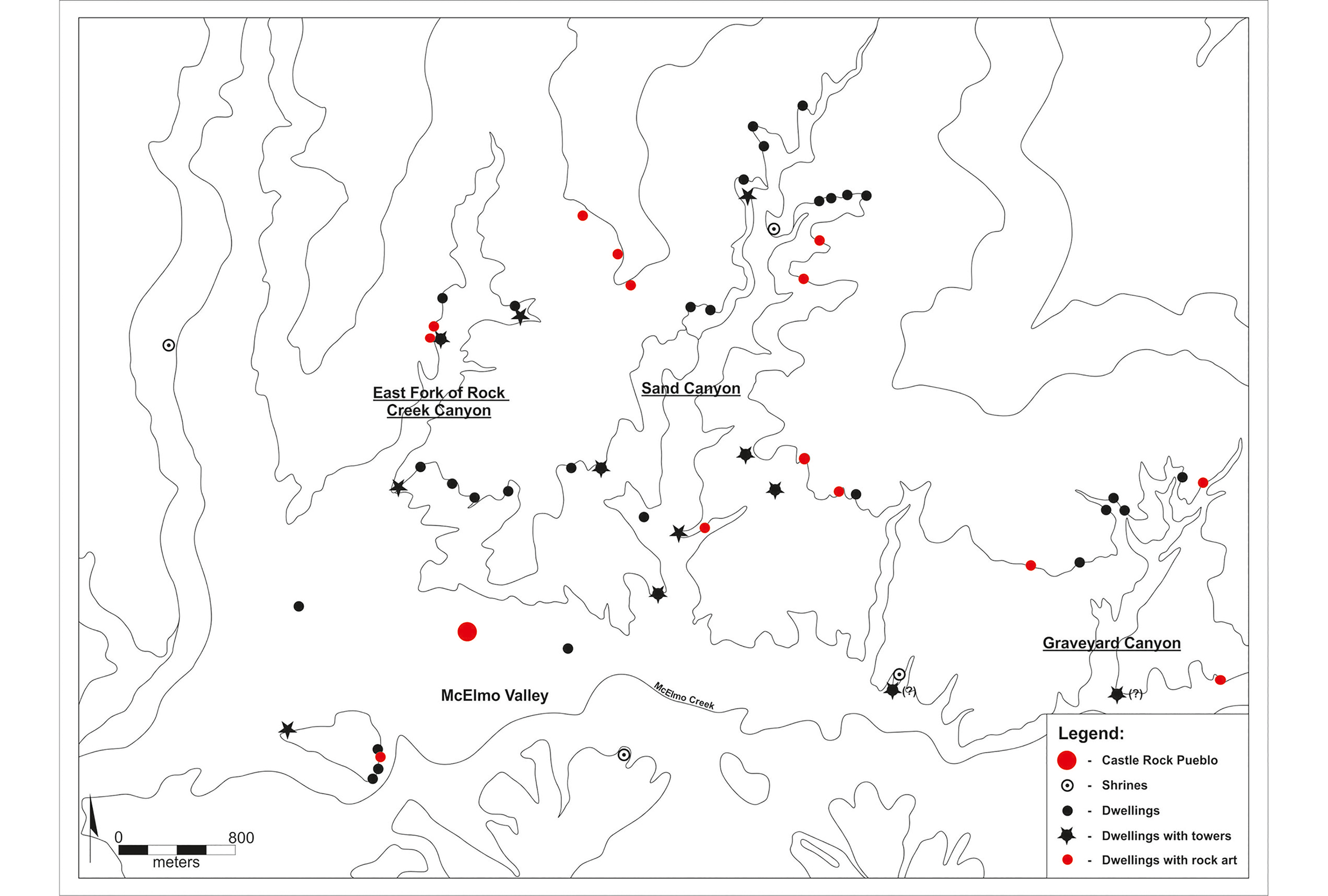
Since 2011, archaeologists from the Institute of Archaeology at the Jagiellonian University in Krakow have been taking part in the Sand Canyon-Castle Rock Community Archaeological Project in the central Mesa Verde region. This research focuses on the reconstruction of settlement structure and documentation of rock art at dozens of sites that may have functioned as one Puebloan community (Figure 1; Palonka Reference Palonka2011, Reference Palonka, Kadrow and Włodarczak2013, Reference Palonka2017, Reference Palonka and Oram2019a & Reference Palonkab; Palonka et al. Reference Palonka, Słupianek and Nawrot2015). In particular, the project explores the inter-relationships between particular settlements, and the role of the towers and shrines as a means of visual communication in the functioning of this system.
Location of sites in Castle Rock Pueblo Community dated mostly to the thirteenth century AD (drawing by M. Znamirowski).
The team has also obtained dates from dendrochronological samples and pottery analysis that are more accurate than previously achieved. This evidence has allowed us to speculate that, contrary to some earlier research (or at least questioning if some or most), small sites may have functioned contemporaneously with the community centre (e.g. Kuckelman Reference Kuckelman2000). The community centre was the largest site in the community that also comprised public buildings, such as plazas or large kivas (ritual buildings). Together, these sites may have formed a community that was connected by strong religious and social ties. Additionally, we have collaborated with the Canyons of the Ancients National Monument, Crow Canyon Archaeological Center, the Maryland Institute College of Art and the Hopi Cultural Preservation Office to gather more comprehensive information concerning past landscape use, based, in part, on the Pueblo oral tradition. Taken together, these findings illuminate the operation and final days of one of the largest communities of Ancient Pueblo culture in the Mesa Verde region in the thirteenth century AD.
Castle Rock Community
Sand Canyon, East Fork of Rock Creek Canyon and Graveyard Canyon are located in the Lower Sand Canyon locality of Montezuma County, south-western Colorado, and form part of the Canyons of the Ancients National Monument. These areas contain the remains of approximately 40 ancient Pueblo sites, all dating roughly to the thirteenth century AD. During this time, they may have created a community of allied sites. The term ‘Castle Rock Community’ refers to Castle Rock Pueblo (site 5MT1825), the largest site (and the centre of the network of allied sites) and nearby small sites that were probably linked with it (Varien Reference Varien1999a; Ortman Reference Ortman, Varien and Potter2008; Palonka Reference Palonka2011). The elevation of the study area ranges from approximately 1650–2100m asl, with most of the sites located between 1650 and 1800m asl.
Initial descriptions of some sites in the Lower Sand Canyon locality, including Castle Rock Pueblo, were provided by the 1874–1876 Hayden Geological Survey (the Hayden Expedition), the first U.S. government-funded military and scientific expedition to this area (Jackson & Holmes Reference Jackson and Holmes1981). At the beginning of the twentieth century, a few scholars and local residents described and photographed some local cliff dwellings, but the first professional surveys were instigated by archaeologists starting in the 1960s (e.g. Martin et al. Reference Martin, Lister and Breternitz1971; Adler & Metcalf Reference Adler and Metcalf1992; Gleichman & Gleichman Reference Gleichman, Gleichman and Lipe1992). Three sites have been partially excavated by Crow Canyon Archaeological Center in the 1990s (Varien Reference Varien1999a; Kuckelman Reference Kuckelman2000).
Since 2011, we have partially or fully surveyed 35 of the 40 or so small ancient Puebloan sites using non-invasive techniques. We have also documented part of the Castle Rock Pueblo with a particular focus on the rock art. Our methods include photogrammetry and laser scanning. We have also conducted geophysical survey—primarily electrical resistivity and magnetometry—at several sites and conducted test-pit excavations at three sites, and tree-ring sampling at eight sites. In 2016 and 2017, we interviewed members of the Hopi tribe from the Hopi Cultural Preservation Office, who are descendants of ancient Pueblo people.
Changing settlement structure in Castle Rock Community: evidence of increasing violence
Pueblo societies in the thirteenth-century AD Mesa Verde region were faced with many environmental, demographic and social challenges. The story of these disruptions is informed by archaeological data, including changes in architecture and site layout, a shift in site locations from uplands and mesas to canyon rims (so-called ‘canyon-head’ settlements), and the use of cliff alcoves or natural shelters or niches (cliff dwellings) near water sources. Settlement patterns also changed, with settlements increasing in size, sometimes from 50 to 700 rooms. Many types of public and defensive architecture, including plazas, great kivas, D-shaped buildings, towers and massive stone walls enclosing villages, were constructed in this period (Varien et al. Reference Varien, Lipe, Adler, Thompson, Bradley and Adler1996; Kenzle Reference Kenzle1997; Lipe & Varien Reference Lipe, Varien, Lipe, Varien and Wilshusen1999; Lipe Reference Lipe, Varien and Wilshusen2002; Kohler et al. Reference Kohler, Varien and Wright2010; Palonka Reference Palonka2011). Additionally and contemporaneously, settlements in the central Mesa Verde region included clusters of habitations consisting of a community centre and around 15–40 small settlements associated with the centre (Varien Reference Varien1999b).
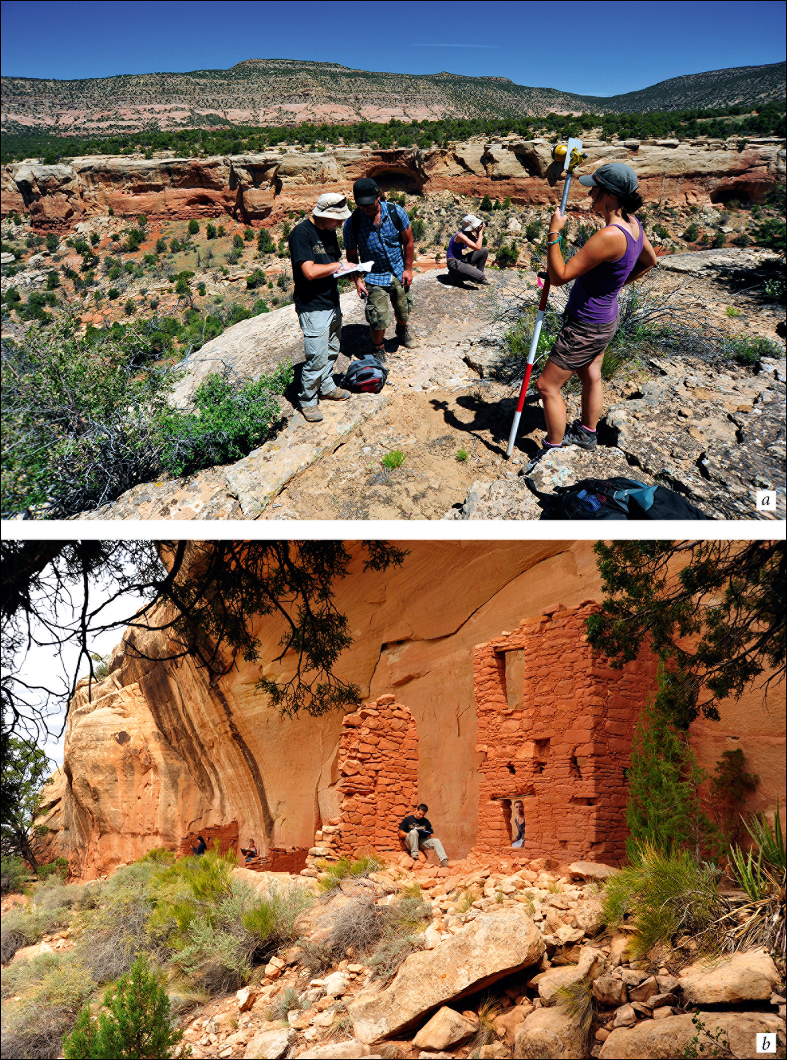
Approximately 60 community centres existed in the central Mesa Verde region in the Late Pueblo III period, c. AD 1225–1280 (Lipe & Varien Reference Lipe, Varien, Lipe, Varien and Wilshusen1999: 303–10; Varien Reference Varien1999b; Lipe Reference Lipe, Varien and Wilshusen2002; Glowacki Reference Glowacki2015). Serving as hubs for social, political, religious and economic activities for smaller sites, they represent one of the longest occupied sites in the region. Inhabitants’ preferences in terms of settlement location and architecture in the thirteenth-century AD Mesa Verde region are also evident in the Castle Rock Community (Lightfoot & Kuckelman Reference Lightfoot, Kuckelman, Rice and LeBlanc2001; Palonka Reference Palonka2011, Reference Palonka, Kadrow and Włodarczak2013). Here, the data suggest that even the small sites located in cliff alcoves were situated in a defensive manner, with ladders required to access many of them. Of the 41 sites in this community, at least 31 are located in difficult-to-reach cliff alcoves (Figures 2–3) and associated talus slopes. Protective walls with loopholes (narrow slits) for observation extend along the entire length of the alcove, and constitute the only entryway into at least four alcoves where dwellings were located. Some alcoves probably functioned as refuges (during an attack or raid) for inhabitants who lived below the alcoves. The community centre, Castle Rock Pueblo, is situated atop and around the base of a 20m-tall butte, also in a defensive manner.
Archaeological survey in Sand Canyon: a) with a few small cliff dwellings visible in the background; b) one of the cliff dwellings, site 5MT1805 (Two Story House) (photographs by R. Słaboński).
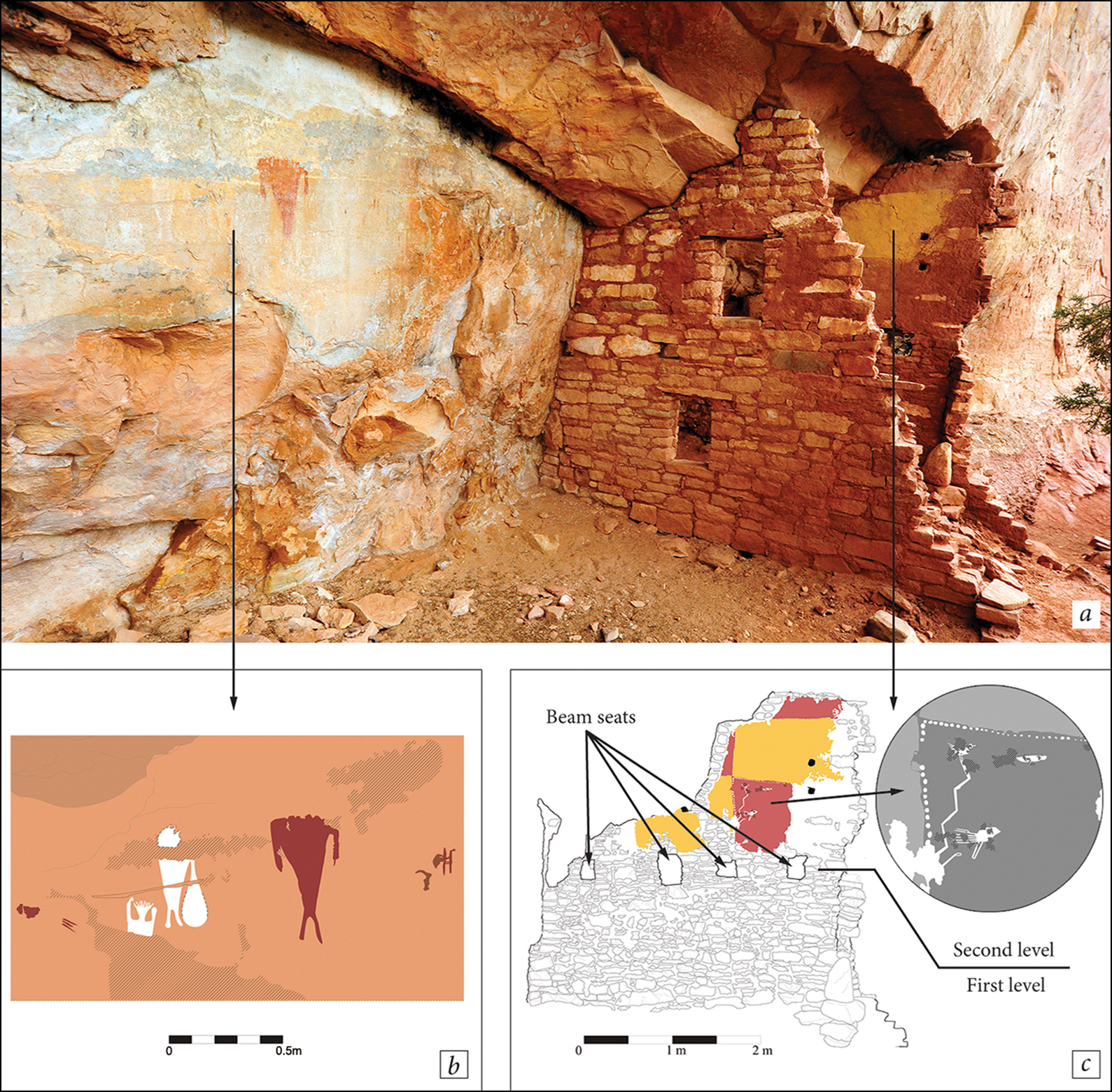
a) Part of site 5MT264 (The Gallery) with rock art panel (b) and preserved plaster and paintings on the walls of Room B (c) (photograph by R. Słaboński, drawings by A. Kucia & M. Znamirowski).
Castle Rock Pueblo consists of more than 70 rooms. Dendrochronology suggests that the community centre was probably founded in the AD 1250s (Kuckelman Reference Kuckelman2000). The latest such date from the site is AD 1274, after which occupation of the site probably ended. Excavations conducted in the 1990s by the Crow Canyon Archaeological Center have revealed evidence implying a brutal attack, including human remains representing at least 41 unburied individuals, some of whom showed evidence of violent death, as well as burned structures (Kuckelman Reference Kuckelman2000; Lightfoot & Kuckelman Reference Lightfoot, Kuckelman, Rice and LeBlanc2001). These data correspond with the oral tradition of the Hopi people recorded in the 1870s about an ancient battle with the Ute Indians that may have taken place at Castle Rock (Jackson & Holmes Reference Jackson and Holmes1981; Lightfoot & Kuckelman Reference Lightfoot, Kuckelman, Rice and LeBlanc2001). These data point to growing warfare that occurred between different Pueblo groups (or with non-Pueblo people) during the thirteenth century AD.
The role of the towers and intervisibility
Situated strategically in highly visible locations, towers could facilitate rapid communication among allies. Such intervisibility, and its significance during times of conflict, has been documented cross-culturally in different areas of the Southwest, such as on Perry Mesa in central Arizona, in the Kayenta region in north-eastern Arizona, in the Chaco World, and in experimental studies of intervisibility between Navajo pueblitos of the Dinétah region in north-western New Mexico (e.g. Haas & Creamer Reference Haas and Creamer1993; Ahlstrom & Roberts Reference Ahlstrom and Roberts1995; Wilcox et al. Reference Wilcox, Robertson, Wood, Rice and LeBlanc2001; Bryan Reference Bryan2009; Van Dyke et al. Reference Van Dyke, Bocinsky, Windes and Robinson2016; Kantner & Hobgood Reference Kantner and Hobgood2016). Similar visual communication between sites that could provide warning in times of danger has also been recorded both archaeologically and in written sources for early medieval strongholds in Europe (e.g. Dulinicz Reference Dulinicz2001).
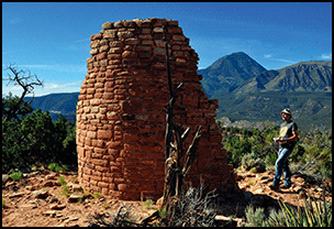
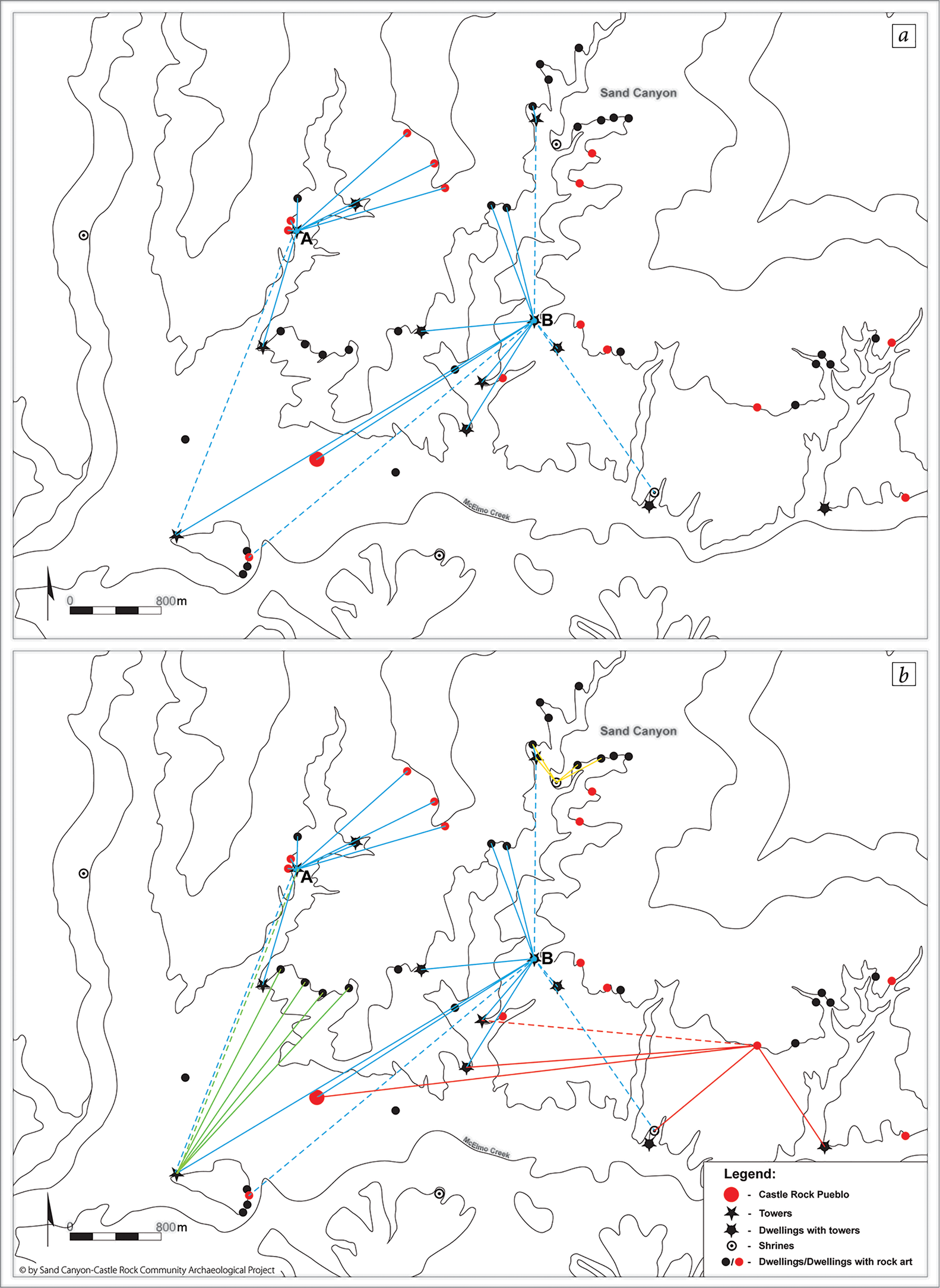
We mapped, for the first time, all of the towers across the entire Castle Rock Community. Here, at least eight sites contained towers or had towers in their proximity (Figure 4), including nine towers at Castle Rock Pueblo. While some towers are located within the sites’ boundaries, there are also a few ‘free-standing’ towers close to habitation sites (within 40–120m; we consider all of these towers to have been associated with the nearest habitation). We propose that the primary function of these towers was communication (Figure 5), as most are intervisible with nearby sites (based on direct field observations and GIS analysis; we also conducted an experiment using mirrors to prove the possibility of eye-contact between some sites); a secondary function might have been for defence or for monitoring the agricultural lands. Also, within the Castle Rock Community, we examined six clusters of sites that consist of four or more sites situated either near to each other, or within visual contact (Palonka et al. Reference Palonka, Słupianek and Nawrot2015; Palonka Reference Palonka and Oram2019a).
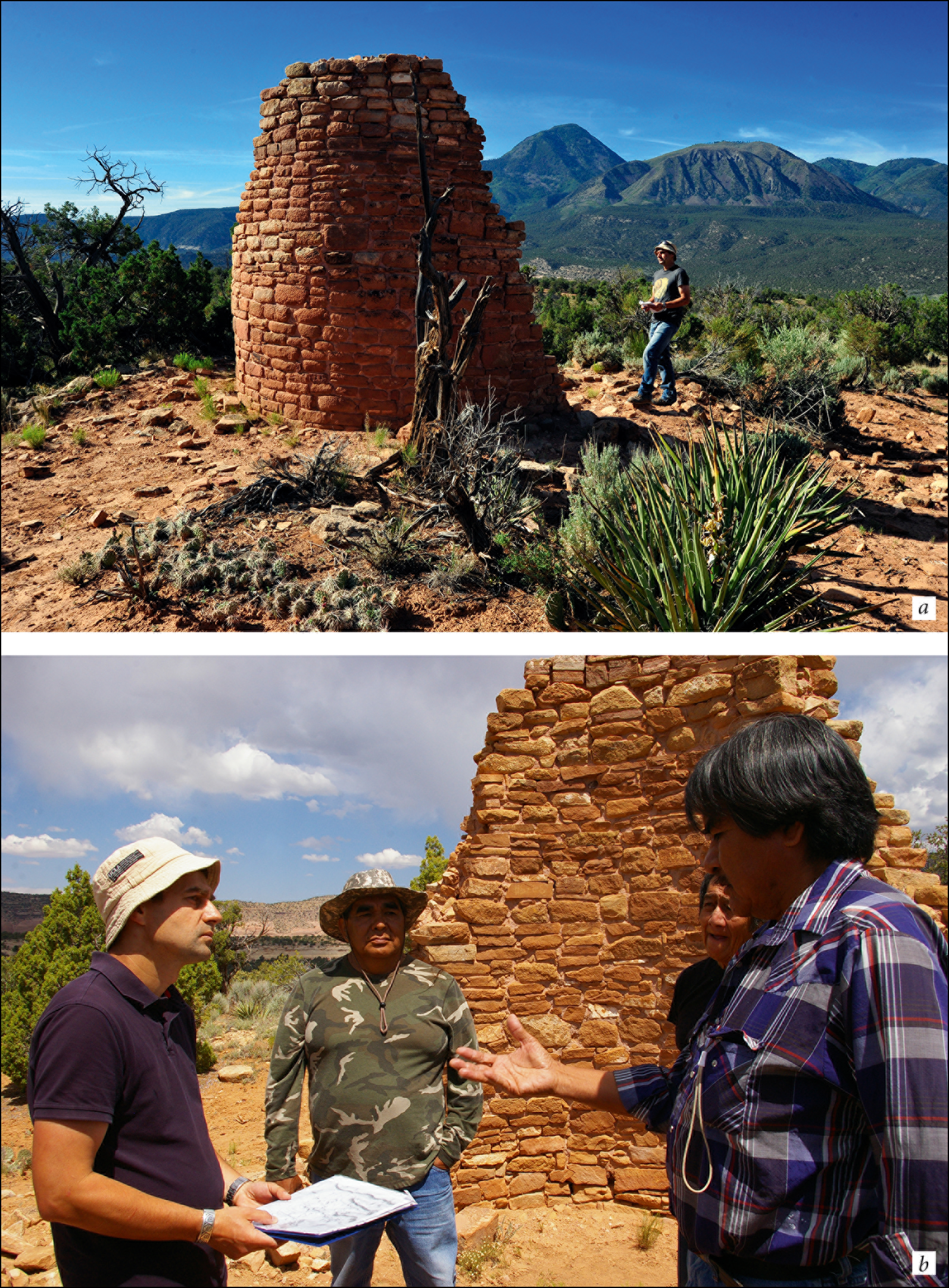
a) Documentation of site 5MT181 (Mad Dog Tower) with Sleeping Ute Mountain in the background; b) consultations with Hopi representatives, from the right: R. Wadsworth, G. Nicholas, L. Wayne Lomayestewa and R. Palonka (photographs by R. Słaboński & R. Kozłowski).
Examples of intervisibility between two towers (A: tower at site 5MT1842; B: Mad Dog Tower), shrines and cliff dwellings in the Castle Rock Community (dashed lines represent possible eye-contact; drawings by R. Palonka & M. Znamirowski).
As in other parts of the Mesa Verde region and beyond, some of the towers in the Castle Rock Community may also have been used for ceremonies, monitoring game, astronomical observation and/or for food storage (Schulman Reference Schulman1950; Varien et al. Reference Varien, Lipe, Adler, Thompson, Bradley and Adler1996; Kenzle Reference Kenzle1997; Lipe & Varien Reference Lipe, Varien, Lipe, Varien and Wilshusen1999; Johnson Reference Johnson2003; Thompson Reference Thompson2004; Palonka Reference Palonka and Oram2019a). Research of eleventh-century AD tower kivas in the Chaco World (Kantner & Hobgood Reference Kantner and Hobgood2016) suggests that although defence and long-distance communication were probably not a primary function of these towers, their height might have at least increased the intervisibility with nearby households. Generally, the intervisibility and visual communication between sites would have been especially useful in times of danger; residents of particular sites may have used smoke or fire signals to warn the inhabitants of other sites of approaching attackers.
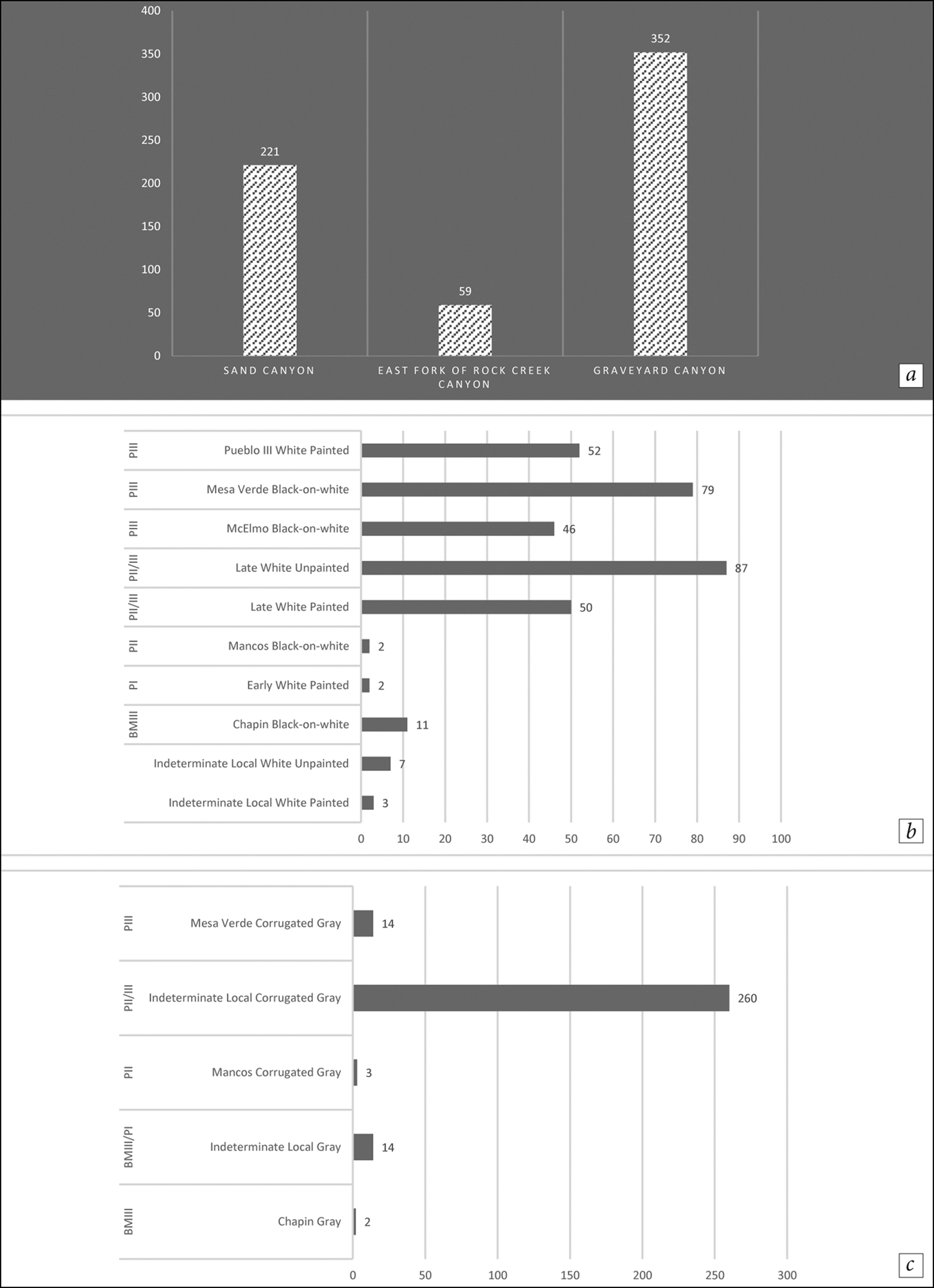
Our research provides indirect evidence that intervisible sites in the Castle Rock Community were contemporaneous—a theory also supported by our recent analyses of tree-ring samples and pottery (with a predominance of McElmo Black-on-white and Mesa Verde Black-on-white styles; the latter is relatively late and dates to the thirteenth century AD) (Figure 6). At least four small sites in the Community have cutting or near-cutting dates starting at AD 1252–1254 (the latest date is AD 1271 from site 5MT135-Sunny Alcove); the latest date from Castle Rock Pueblo is AD 1274. (Cutting dates are assigned to those tree-ring samples with clear evidence that the outermost ring on the specimen is also the last ring grown by that tree before it died (Ahlstrom Reference Ahlstrom1985: 38); as cutting dates indicate when a tree was felled, they can be directly related to prehistoric wood procurement and use.) This evidence further enriches our understanding that the people who lived in this area created a network of allied sites over several decades, but were finally subject to violent attacks (as previously mentioned for the Castle Rock Pueblo).
Typology and chronological affiliation of pottery collected by the project from sites in the Castle Rock Community (BM—Basketmaker period; P—Pueblo period) (figure by K. Ciomek).
Shrines and the landscape as boundary markers
Previous research has explored the role of shrines in defining community boundaries. In our analysis, we estimated the approximate area of the Castle Rock Community based on Varien's (Reference Varien1999b) estimates of the size of community catchments (up to 4–5km in radius from the community centre); the boundary of the Community also follows Ortman's (Reference Ortman, Varien and Potter2008) proposal that it is marked by four shrines—stone circles—measuring approximately 5–10m in diameter. Each shrine is situated “in a significant location, one that relates Castle Rock to the cardinal directions, the surrounding landscape, and prominent topographic features on the horizon” (Ortman Reference Ortman, Varien and Potter2008: 134).
These topographic features may include Sleeping Ute Mountain to the south, Mesa Verde to the east, the La Plata Mountains to the north-east, and Bears Ears to the north-west—all prominent landscape features located between a few kilometres and up to 140km from the Community. Three of the shrines open towards Castle Rock Pueblo; one opens south towards Sleeping Ute Mountain, the highest mountain in the local vicinity, rising to around 3000m asl.
The shrines that are generally considered to represent community boundary markers had both ritual and spiritual functions, and are also known from the ethnographic literature of various Pueblo societies, including the Hopi, Zuni, Keres and Tewa (Ortiz Reference Ortiz1969; Van Dyke Reference Van Dyke2007; Ortman Reference Ortman, Varien and Potter2008; Van Dyke et al. Reference Van Dyke, Bocinsky, Windes and Robinson2016). According to the beliefs of the Ohkay Owingeh (San Juan Pueblo), their settlements are surrounded by four sacred mountains, each assigned a different colour: north is blue or green, west is yellow, south is red and east is white. Additionally, the boundaries of their settlements are defined by mesas and stone shrines, all located by the cardinal directions to the north, south, east and west of the settlement (Ortiz Reference Ortiz1969: 19).
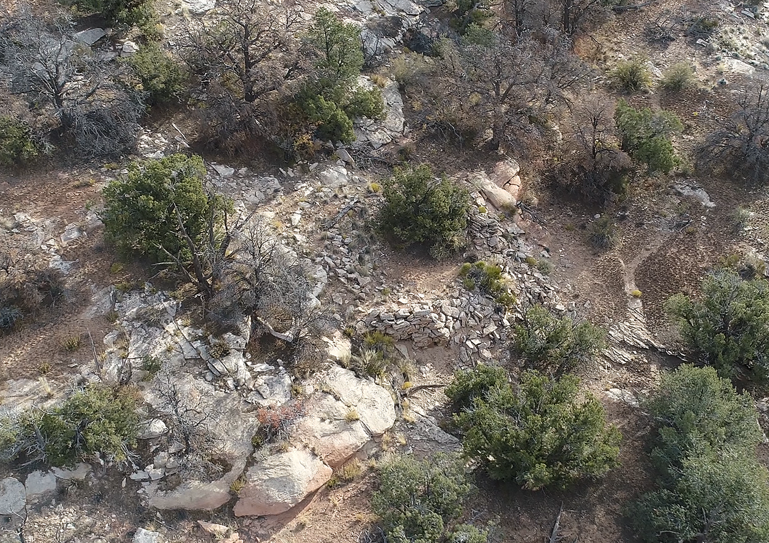
Our research has documented, in detail, two of the four shrines located in Castle Rock Community: the northern shrine (site 5MT2796) located in Sand Canyon, and the as yet unnamed easternmost shine located between Sand Canyon and Graveyard Canyon (Figures 7–8). The northern shrine is situated on a knoll overlooking the central part of Sand Canyon. The site consists of a circle made from unshaped, dry-laid stone, with somewhat poorly preserved walls, although on its western side, the wall survives to at least 1.5m in height. The single opening in this shrine points directly towards Sleeping Ute Mountain, the highest peak of the Ute Mountains. At least five sites are located in close proximity to the shrine, on the same side of the canyon. On the opposite side, approximately 250m to the north-west of the shrine, there is the tower (site 5MT13446) and a cliff dwelling, site 5MT135 (Sunny Alcove).
The northern shrine (site 5MT2796) located in Sand Canyon; the shrine is visible from several other sites, including at least one tower (photograph by B. Zych).
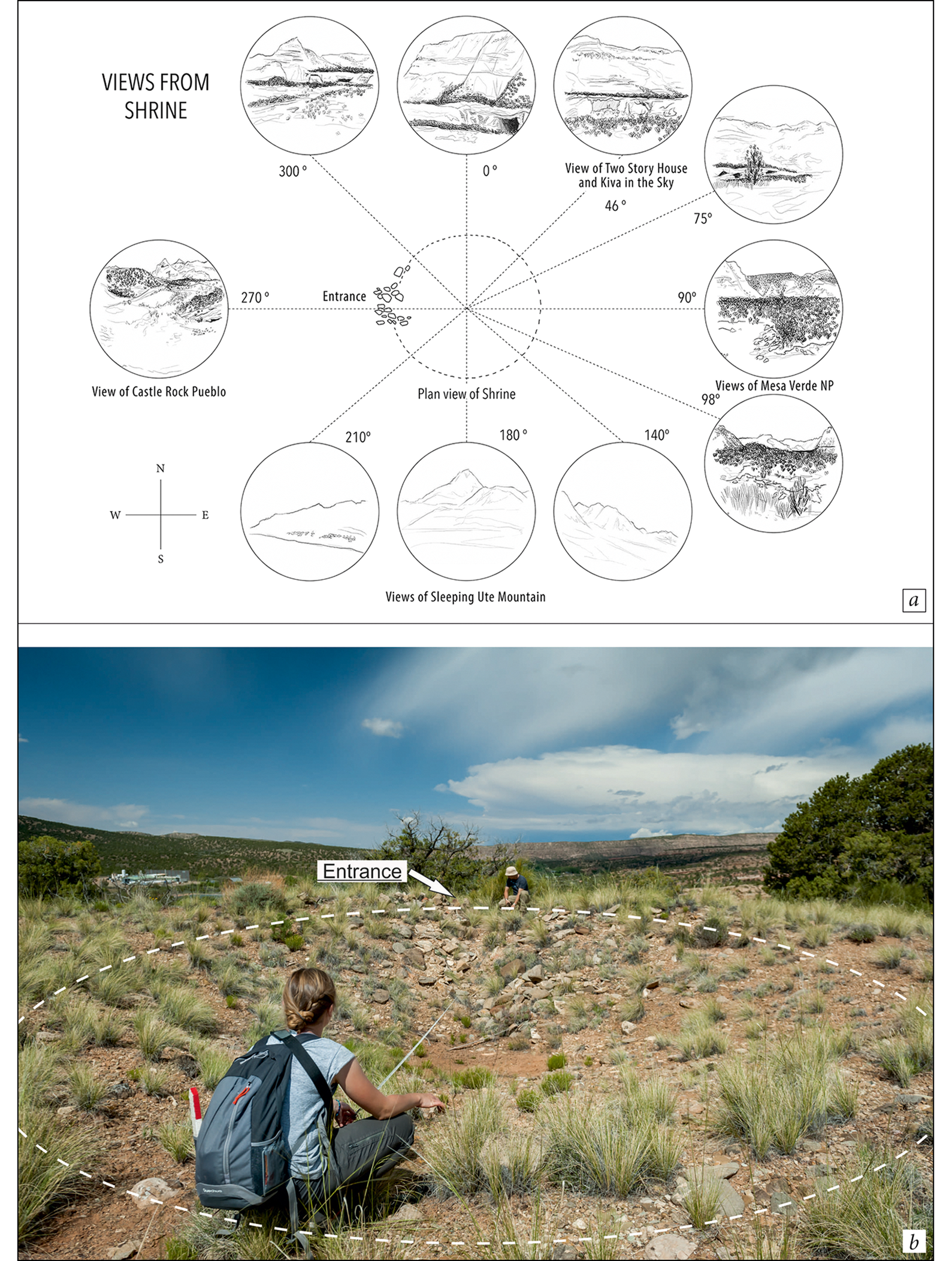
a) Views from the eastern (unnamed) shrine; b) documentation of the shrine (drawings by B. Gooch & Z. Xu; photograph by M. Znamirowski).
The unnamed shrine
We documented several new sites in 2016 and 2017, including the unnamed eastern shrine (Figure 8), and created topographical maps using graphic viewshed analyses, as an aid for studying the thirteenth-century AD cultural landscape. The documentation process included photographing the unnamed shrine, taking measurements and analysing the landscape features and ancient Pueblo sites that are within sight of, or may be visible from, the shrine. The Maryland Institute College of Art team made extensive drawings of the landscape as viewed from the unnamed shrine.
The unnamed shrine is one of four found in the Lower Sand Canyon area, and was probably strictly connected with the Castle Rock Community. It is located directly to the east of Castle Rock Pueblo, in a geographically prominent area. Its higher elevation and close proximity to the edge of the lower canyon rim affords a view of part of the McElmo Creek Valley. The main entrance of the stone circle faces directly west (270°), pointing towards the Castle Rock Pueblo, which is located approximately 3km from the shrine. Directly to the north is the upper level of the canyon rim (approximately 1.1km from the shrine), which contains the other thirteenth-century AD Pueblo cliff dwellings, including site 5MT1805 (Two Story House) and site 5MT1806 (Kiva in the Sky). The Mesa Verde National Park, which hosts the largest cliff dwellings known to date, is located 20–25km from the shrine, and can be partially seen directly to the east.
Although now obscured by vegetation, other sites, such as site 5MT181 (Mad Dog Tower), would have been observable from the unnamed shrine. To the south sits the most prominent feature of the area: Sleeping Ute Mountain, with the tallest point on its peak located at 180° from the centre of the shrine. The mountain contains ecozones with many trees larger than those of the Lower Sand Canyon locality, access to large game animals, such as deer and elk, and several natural springs. These ecozones were probably extremely important given the unpredictable precipitation and farming conditions of the thirteenth century AD. This shrine could have also been important, as it was visible from nearly all of the surrounding sites, assuming that there were fewer trees in the past due to deforestation and the depletion of local resources, for land clearance and the collection of wild foods and materials for construction (e.g. Lipe & Varien Reference Lipe, Varien, Lipe, Varien and Wilshusen1999; Dean & Van West Reference Dean, West, Varien and Wilshusen2002). Along with the view of Sleeping Ute Mountain and the shrine's proximity to the canyon edge, it can be concluded that it once held some ritual significance for the ancient Pueblo people.
Rock art and Native American consultation
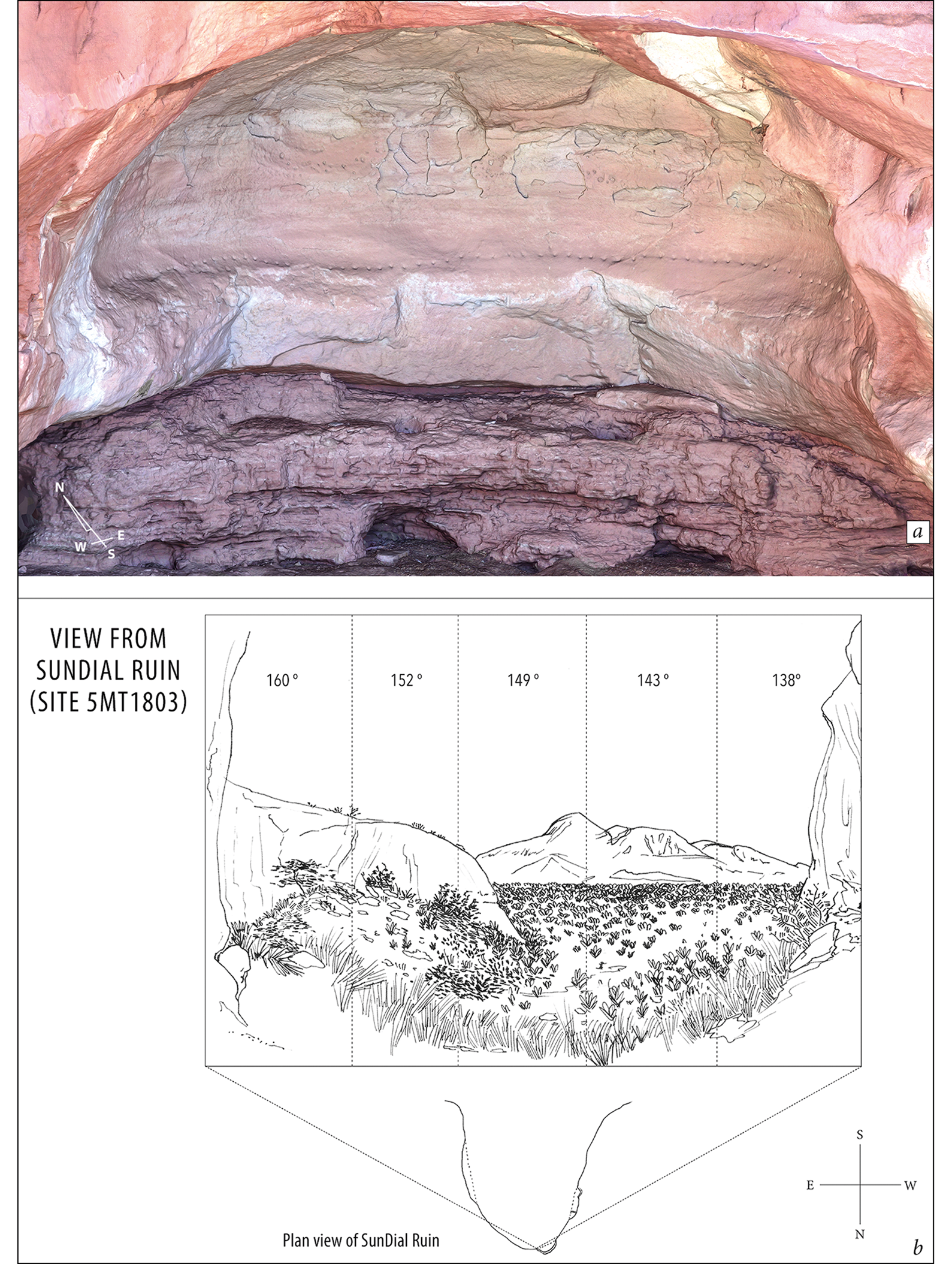
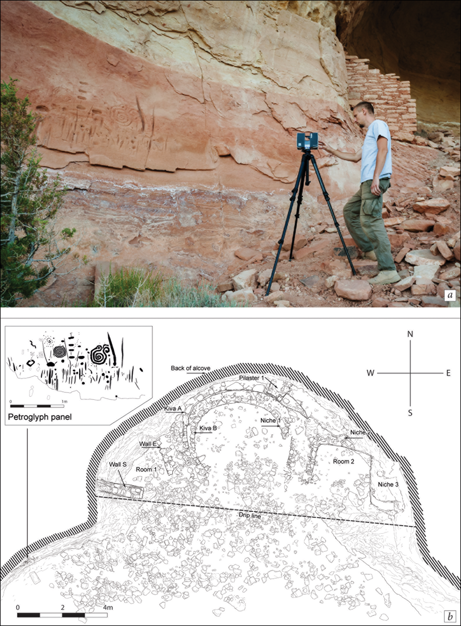
We documented ancient Pueblo rock art at 15 Castle Rock Community sites, represented by both petroglyphs and paintings, including warriors fighting with bows and arrows (a well-known panel from Castle Rock Pueblo), concentric circles, spirals, zig-zag lines, bird tracks and foot- and handprints. Other motifs could be interpreted as being connected with astronomical observations (Palonka Reference Palonka2017, Reference Palonka2019b) (Figures 9–10). The rock art can be roughly dated to the Pueblo III period (AD 1150–1300), and was probably created sometime in the thirteenth century AD, based on stylistic comparison to other well-dated rock art panels. There are, however, a few cases where we can observe much older rock art within these Late Pueblo III settlements, including anthropomorphic figures with triangular or trapezoidal bodies that are either pecked (at site 5MT127: Vision House) or painted with red and white (at site 5MT264: The Gallery) (see Figure 3). They are often included in the so-called San Juan Basketmaker Anthropomorphic Style (Schaafsma Reference Schaafsma1980; Cole Reference Cole2009), examples of which are also present in nearby Mancos Canyon, and as far as Durango to the north-east (Cole Reference Cole2009).
Site 5MT1803 (Sundial Ruin) in Sand Canyon, with the alcove containing 74 cupules (a possible calendar?) (photograph based on the photogrammetry by C. Moriarty; drawing by B. Gooch & Z. Xu).
a) Site 5MT129 during documentation with the laser scanner by B. Zych; b) map of the site with the petroglyph panel (photograph by M. Znamirowski; drawings by B. Zych & K. Ciomek).
At least two sites in the Community, The Gallery and Two Story House, have surviving plaster murals on the building walls. These were placed in the buildings’ second storey, while the first storey could have served as storage rooms, based on its masonry, which is roughly shaped with no plaster or paintings on the wall, while the second storey has been done with more care and often contains plaster and murals (Lipe & Varien Reference Lipe, Varien, Lipe, Varien and Wilshusen1999). The example at Two Story House comprises brown/reddish and white murals, including what appear to be three roughly preserved triangles. Similar triangles are found in Cliff Palace and other sites from the Mesa Verde National Park. They may represent the mountains (perhaps different peaks of the Ute Mountains) and might have been important religious symbols for the local Pueblo society. As with most of the cliff-dwelling sites in the area, Two Story House faces south, with a clear view of Sleeping Ute Mountain range.
In 2016 and 2017, we also conducted consultations with members of the Hopi tribe (see Figure 4), in order to deepen our understanding of the rock art iconography, the layout and meaning of the architecture, and of the connections between the landscape, rock art and ancient Pueblo sites. Importantly, the Hopi visited Castle Rock Pueblo and their input revealed insights into a previously unknown petroglyph panel. Our Hopi consultants interpret the panel as a map of the canyon showing the locations of important sites, including storage places for maize, as well as water sources, indicated by wavy lines with dots on both sides.
Discussion and conclusions
The central Mesa Verde region, located in south-western Colorado and south-eastern Utah, was one of the areas within the North American Southwest where ancient Pueblo societies lived for more than a millennium. Since 2011, the Sand Canyon-Castle Rock Community Archaeological Project has conducted research in several canyons of south-western Colorado, focusing on the reconstruction of various aspects of Pueblo life in the thirteenth century AD—the final period of Puebloan occupation of the area. Research has focused on a cluster of 40 sites around the large settlement of Castle Rock Pueblo. Furthermore, the project has documented evidence for the numerous links between ancient Pueblo settlements and rock art, shrines and the surrounding natural landscape of canyons, mountain peaks and mesas. Environmental and climatic disturbances during the thirteenth century AD resulted in competition for reduced resources, including water and farmland, and increasing conflict and violence. As a result of these problems, across the entire Mesa Verde region, Puebloan occupation had ceased by the end of the thirteenth century, with migration to present-day Arizona and New Mexico (e.g. Lipe Reference Lipe1995; Lipe & Varien Reference Lipe, Varien, Lipe, Varien and Wilshusen1999; Kohler et al. Reference Kohler, Varien and Wright2010).
The chronological data based on tree-ring dates, pottery typology and architectural styles indicate that all of the small sites, along with the community centre, were inhabited in the thirteenth century AD, although it is difficult to determine whether all of the sites were built and used contemporaneously. Certain sites may have also been inhabited during the late AD 1100s. Dendrochronological dates collected by our project, however, suggest that at least some of the small sites were occupied in the second half of the thirteenth century AD—at the same time as Castle Rock Pueblo. This is also supported indirectly by the intervisibility between most of the sites in the Community. This evidence may contrast or address unanswered questions from previous research on the Castle Rock Community and other Mesa Verde communities, suggesting that people left some of the small sites to establish larger centres (for example, for defence), particularly in the second half of the thirteenth century AD (e.g. Varien et al. Reference Varien, Lipe, Adler, Thompson, Bradley and Adler1996; Kuckelman Reference Kuckelman2000; Lipe Reference Lipe, Varien and Wilshusen2002).
Our research shows that nearly all of the settlements in the Castle Rock Community were arranged in a pre-planned layout, with almost every one situated in sight of several other sites, or at least within view of the stone towers that were probably important for defence or in relaying communications between sites. This signalling probably served to warn against enemy attacks, or to announce the convening of ceremonies, and could have been achieved using fire, smoke and/or pyrite or mica mirrors (Bryan Reference Bryan2009; Gallaga Reference Gallaga2014). Such communication permitted the swift relay of messages, sometimes over long distances, which is confirmed in the case of other places in the Southwest. This information also derives from the Spanish records; signals were probably received from other villages, or runners were sent in warning. Potential visual contact and communication between sites and towers was probably one of the key—if not the most important—elements in the survival of such a community in the changing cultural and environmental landscape of the late thirteenth-century Mesa Verde region.
The four stone circles, or shrines, were extremely important to this whole micro-region and system of visual communication between settlements, and were undoubtedly linked to religious practices. In historic Pueblo communities, shrines were used for the placement of offerings and religious practices, while also serving as markers designating a characteristic place in the settlement cluster, or even the boundary markers of a community's maximum range (Ortiz Reference Ortiz1969; Van Dyke Reference Van Dyke2007). Indeed, the boundary of the Castle Rock Community may have been marked by these four shrines. The shrines have openings/entrances facing towards Castle Rock Pueblo—the largest settlement in the Community—or towards the south, where the highest peak in the area, Sleeping Ute Mountain, rises to approximately 1200m above the Community, which is located at approximately 1750–1800m asl.
Most of the Community's cliff-dwelling sites face to the south or south-east. While practical considerations directed settlement southward (e.g. more heat from the low winter sun enters buildings located in rockshelters), Sleeping Ute Mountain must have also had a religious and spiritual dimension. The Two Story House, for example, has a poorly preserved painted mural of what appear to be triangles, which probably symbolise the mountain peaks. Both the mural and the site face south towards the Sleeping Ute Mountain. Fifteen other sites in the Community also include paintings and petroglyphs, some of which may be associated with representations of astronomical phenomena and constellations.
The Ute Mountains may have been of great economic importance, not only for their timber, but also for hunting deer, elk and bear. Sleeping Ute Mountain itself often attracts clouds and rain, and was thus undoubtedly of great importance for Pueblo communities living in the canyons, especially during dry periods. Today, evoking the rain is of fundamental importance in the beliefs and dances of the kachina rituals of some Pueblo groups (e.g. Cordell Reference Cordell1997; Plog Reference Plog1997). Our consultants from the Hopi tribe, one of the Pueblo groups, say that the Mountain probably had special religious significance for their ancestors who, more than 750 years ago, built their settlements in the surrounding canyons. Sleeping Ute Mountain is also sacred to the Ute tribe, which has a reservation there today. The Ute people say that Sleeping Ute Mountain represents a sleeping warrior, the shape of whom can be discerned by viewing the mountain range from the north-east.
Our research, comprising maps demonstrating intervisibility between towers, cliff dwellings, shrines and landscape features, along with new dendrochronological dates and pottery analyses demonstrate that the entire settlement cluster of Castle Rock Community may have functioned contemporaneously during a single period. These data, along with contributions of oral history from Hopi consultants, support and enrich previous evidence of the Community's response to increasing conflict and violence in the area during the thirteenth century AD.
Detailed analysis of the Castle Rock Community settlement structure, landscape features and placement of rock art panels allows for new interpretations and theories concerning past decisions around the selection of locations for human settlements and for associated rituals that took place within them, as well as migrations from different areas (both in the Mesa Verde region and worldwide). This research also emphasises the important role of Native American oral tradition for informing archaeological interpretations and contributing to the protection of cultural heritage.
Acknowledgements
We are very thankful to Vince MacMillan from the Canyons of the Ancients National Monument, U.S. Bureau of Land Management and Mark D. Varien from Crow Canyon Archaeological Center (CCAC) for their invaluable help during the project research. Thanks also go to Kari Schleher from CCAC for her help with the pottery analysis, as well as to Tom Windes for collecting tree-ring samples. We would also like to express our gratitude to Barbara Mills and the anonymous reviewers for their comments, and to Maria O'Meara for her help with the final shape of the paper. Our research in the USA was made possible mainly by the National Science Centre, Poland (grants UMO-2013/11/D/HS3/01879 and UMO-2017/26/E/HS3/01174), as well as some support from the U.S. Bureau of Land Management, Crow Canyon Archaeological Center and the U.S. Consulate General in Krakow.


 Open access

