

Introduction
In recent decades, the Iranian Plateau has been shown to be key to the dispersal of Pleistocene hominin populations into Central and South Asia (Vahdati Nasab et al. Reference Vahdati Nasab, Clark and Torkamandi2013). Most studies have focused on the Zagros highlands and occasionally the central parts of the Alborz range (e.g. Berillon et al. Reference Berillon2007), as well as the north and west of the Central Iranian Plateau (e.g. Bazgir et al. Reference Bazgir2017; Vahdati Nasab et al. Reference Vahdati Nasab2019; Heydari-Guran et al. Reference Heydari-Guran2021). The eastern part of the Plateau, however, has seen limited study (although see Coon Reference Coon1951; Ariai & Thibault Reference Ariai and Thibault1975; Sadraei & Anani Reference Sadraei and Anani2018; Sadraei et al. Reference Sadraei, Farjami, Zafaranlou and Vahedi2022).
The Eastern Iranian Plateau extends from the Strait of Hormuz in the south-west to the borders of the Indian subcontinent in the south-east, and from the north coast of Iran (on the Caspian Sea) to the central plains of Asia, making it particularly significant in terms of hominin occupation and migration (Figure 1). The Tracking Pleistocene Human Occupations in the East of Iran project attempts to clarify various aspects of the Pleistocene occupation of the east part of the Plateau and the role that this area played in the dispersal of hominin populations into Asia.
The location of some of the Palaeolithic sites discussed in the text, as well as the identified localities within the survey area: 1) Kashafrud; 2) Khunk; 3) Mirak; 4) Garmrod; 5) Bawa Yawan; 6) Kaldar (map by A. Sadraei).

Comprehensive survey in the Ferdows-Sarayan-Qaen plains
Field surveys conducted in 2020 and 2022 focused on the north-eastern edge of the Lut Desert, covering an area of around 7000km2 (Figure 2). Due to the size of the survey area, we used intensive pedestrian survey to cover the maximum area possible, with foothills and slopes being the primary focus. The presence of playa lakes and the relatively low altitude of the region, as well as rich sources of basaltic rock and andesite, create unique conditions that would have attracted Pleistocene populations to this area. The surveys revealed 176 new Palaeolithic localities within this landscape. The most common type of sites were open-air, comprising 167 localities, with the remaining nine being rockshelters and caves. All the identified sites contained lithics, which were sampled for further study to determine specific periodisation. The highest number of lithics collected from a single locality was 280, while the smallest was 30. On average, 40 lithics were recorded per site.
Examples of landscape within the survey area (photographs by A. Sadraei).

Of these sites, 24 contained between a minimum of 30 and maximum of 82 stone tools that could be attributed to the Lower Palaeolithic, comprising choppers, large flakes, polyhedrons, massive scrapers, and bifaces comparable to Acheulean industries in Arabia and India (Figure 3). These tools were generally produced from basalt and quartz, and the sites are characterised by their proximity to basalt raw material sources.
Bifaces identified in Ferdows Plain (photograph by A. Sadraei).

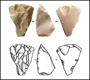
A total of 114 sites produced artefacts with Middle Palaeolithic affinities. These are mainly located on the slopes of moorland heights and covered areas between less than one hectare and tens of hectares. Flint and chert comprise the main raw materials and in some cases thousands of lithics can be identified on the surface. The presence of Levallois technology and points characterises these lithic industries (Figure 4), which are comparable to localities identified on the Central Iranian Plateau (see: Vahdati Nsab et al. Reference Vahdati Nasab, Clark and Torkamandi2013, Reference Vahdati Nasab2019).
Examples of the main Middle Palaeolithic formal tools identified in Ferdows Plain: 1–3) recurrent centripetal Levallois cores; 4–5 & 7–8) Levallois point; 6) Dejete point (scale in cm) (photographs by A. Sadraei).

Eight localities were attributed to the Upper Palaeolithic, characterised by carinated and bladelet cores, along with retouched blades (Figure 5). A further 30 localities have Epipalaeolithic affinities, including backed tools and thumbnail scrapers, and are comparable to the Epipalaeolithic in the Zagros. These assemblages display an increased diversity of raw materials, including jasper, chalcedony and, in some cases, quartz.
Some of the main Upper Palaeolithic and Epipalaeolithic stone tools identified within the survey area: 1) carinated core; 2) bladelet core; 3) point on bladelet; 4) endscraper; 5) notch; 6–7) backed and truncated bladelets; 8) thumbnail scraper (photographs by A. Sadraei).

Conclusion
While Palaeolithic studies have focused on the western and central parts of Iran, our project takes the first step towards recognising the key role that the Eastern Iranian Plateau played in the dispersal of hominin populations into Central and South Asia. The ease of access to stone raw material, the presence of playa lakes and the relatively low altitude of this region compared with the higher north-eastern areas, made this an attractive region for hunter-gatherer populations, as demonstrated by the 176 identified localities that are attributable to the various Palaeolithic subdivisions. The presence of bifacial industries with similarities to Acheulean industries in India and Arabia, and of Levallois technology, and tools characteristic of the Late Palaeolithic, opens a new window for studying the role that this part of Iran played in the dispersal of Pleistocene hominin populations into Central and South Asia, and demonstrates the potential of this area to offer a clearer understanding of the complexities associated with the lithic industries in Asia. Due to the surface contexts of the findings, however, there is a possibility that the assemblages at these sites comprise palimpsests of different periods. It will only be possible to investigate our findings in more detail by conducting stratigraphic excavations at key sites, such as Dagh Jazireh.
Funding statement
This research received no specific grant from any funding agency or from commercial and not-for-profit sectors.


 Open access