


Introduction
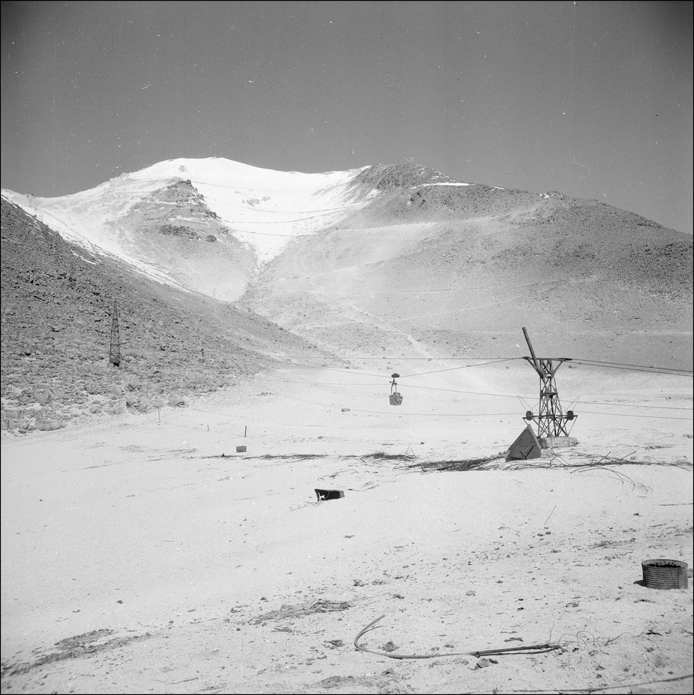
The expansion of capitalism in northern Chile is a story of colonialism, extractivism and enforced integration of Indigenous communities into the Chilean nation. The irruption of extractive industries has been analysed during the past few years from different historical perspectives, but the material impacts and consequences of industrial closures for Indigenous communities, whose livelihoods were transformed twice—first, by industrialisation and then by its dismantlement—are less well studied. The Alto Cielo Archaeological Project focuses on agropastoral sites (estancias) and industrial mining camps in Ollagüe, a Quechua community established in a region known for having the world’s highest sulphur mining sites (5900m) which has been in operation for 100 years (1890–1993) (Figure 1). Echoing recent interest in the complexity of historical transformations in the Andean highlands and its borders (e.g. Saintenoy Reference Saintenoy2024), this is the first project to investigate ruination and deindustrialisation in the highlands of northern Chile. Using archaeological, ethnographic and historical approaches, the project explores how relationships between industrial and agropastoral sites, and the deindustrialisation process of the 1990s, shaped historical memory (High et al. Reference High, Mackinnon and Perchard2017). Analysing the ruins of industrial change forces us to look beyond the aesthetic monumentality of archaeological remains and the static and immutable condition of abandoned sites, to consider their role as ‘living processes’ (DeSilvey Reference DeSilvey2017). This perspective highlights how relationships articulated in the past continue to impact the present, and how contemporary materialities find their echo in dynamic and constantly transforming cultural frameworks.
Aerial ropeways used to transport sulphur at the Aucanquilcha volcano (photograph by William E. Rudolph, c. 1950. Image courtesy of AGSL Digital Photo Archive, University of Wisconsin Milwaukee Libraries digital collections).

Methods
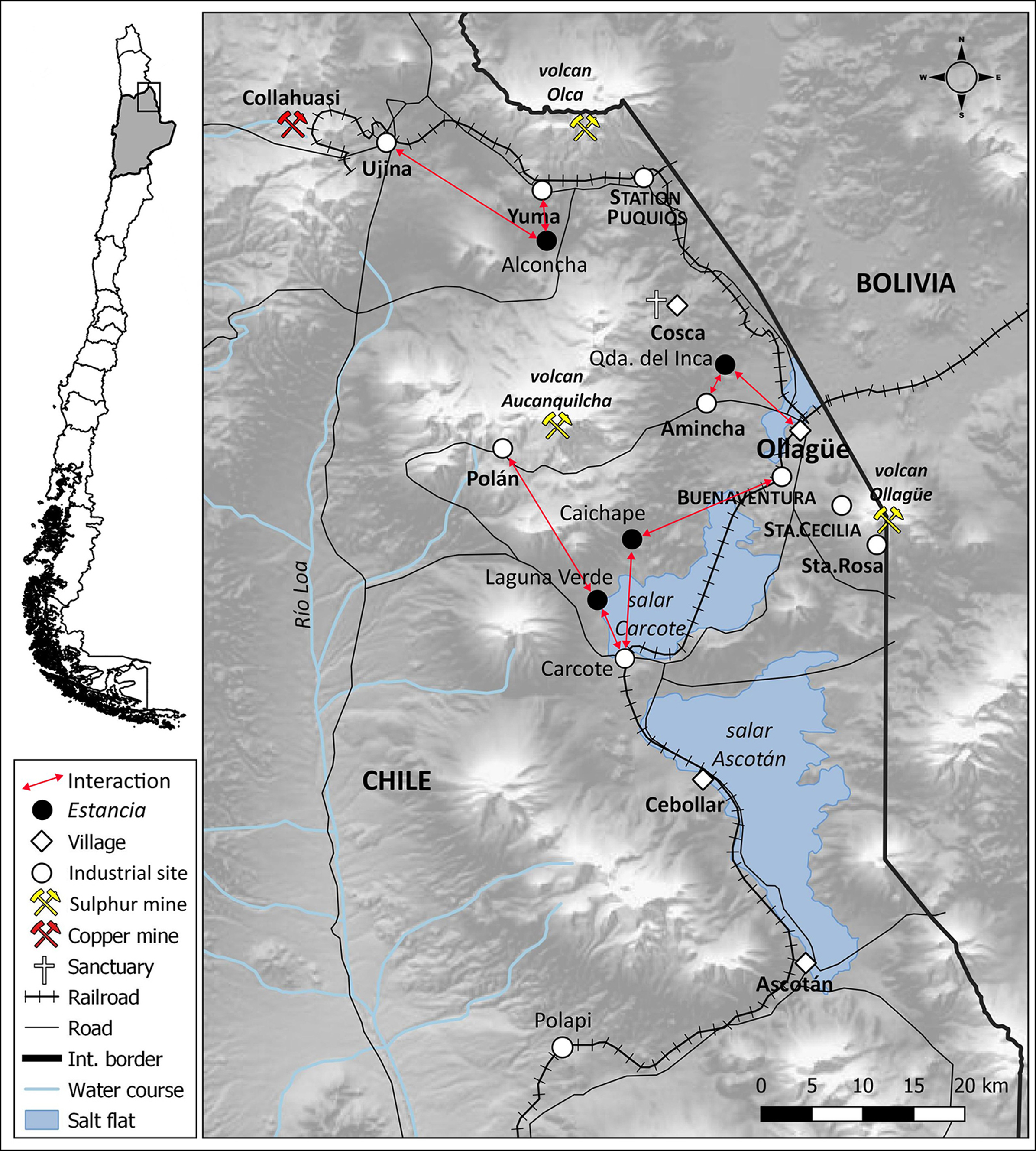
We conducted archaeological research on seven industrial sulphur mining camps and four abandoned estancias in Ollagüe (Figure 2). Archaeological methods focused on the spatial analysis of architecture and surface materials observed in association with functional areas. Sulphur mining sites show clear distinctions between functional areas, including industrial, domestic, public spaces and landfills, while estancias show a separation of functional sectors into domestic and work/husbandry. We compiled a database of sites, architectural features and artefacts using photogrammetry, 3D modelling and spatial analysis software. Data are complemented by historical research from four types of archives: governmental (reports, mining permits, laws); corporate (reports, accounts, inventories); personal (diaries, letters, family photographs); and media (newspapers, magazines). The historical context is enriched by an ethnographic perspective centred on oral history collected through open, semi-structured and in-depth interviews with individuals from two main groups: owners and inhabitants of former estancias; and former workers and inhabitants of industrial sites living in Ollagüe and neighbouring Chilean and Bolivian cities and towns.
Map of the Ollagüe area. Red arrows show connections between estancia and industrial sites (figure by Francisco Rivera).

Preliminary results
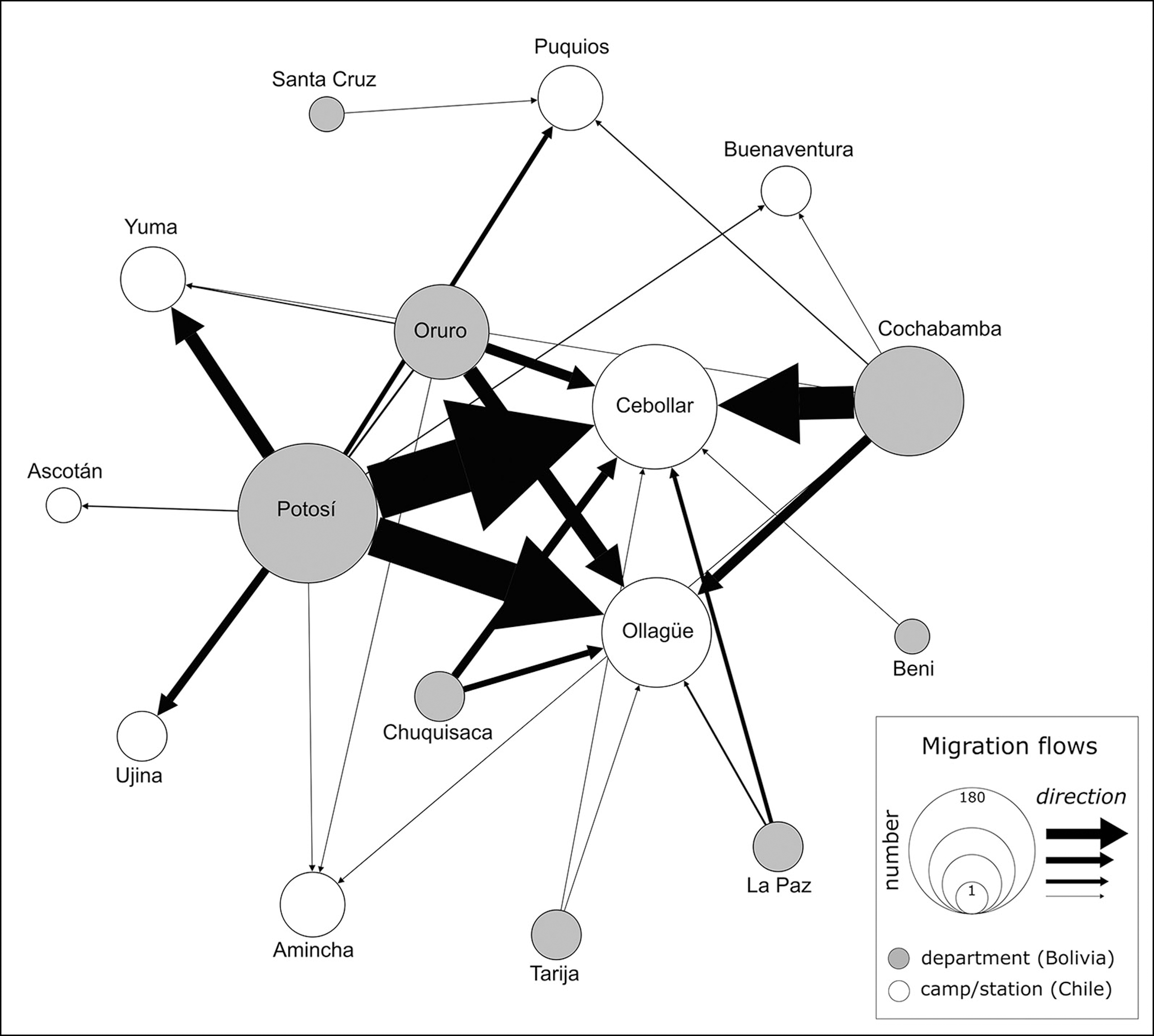
While the irruption of the extractive industries led to new lifeways, local and migrant populations―integrated as labour―maintained social and cultural links with their places of origin, both in northern Chile and south-western Bolivia (Galaz-Mandakovic & Rivera Reference Galaz-Mandakovic and Rivera2023) (Figure 3). In Ollagüe, individuals who participated in capitalist production remained attached to the system of social relations in which domestic economic forms of exchange persisted. In a single year, workers had different roles: they spent a few months in the camps and during the other months they engaged in agropastoral activities in their village. The complementarity of three distinct sources—archaeological, ethnographic and historical—allows us to understand variability and temporality for each site, with large camps built ex-nihilo for local and migrant workers, and smaller estancias occupied by local families on a seasonal basis to supply mining camps with agropastoral resources. This sheds light on the coexistence of mining and agropastoral practices amid the interruption of industrial projects. While the new capitalist logic and modes of production radically transformed the lifeways of local populations, individuals constantly moved between two worlds: agropastoral and industrial (Vilches & Morales Reference Vilches and Morales2017).
Migration flows between 1890 and 1946, based on data in Galaz-Mandakovic & Rivera Reference Galaz-Mandakovic and Rivera2023 (figure by Francisco Rivera).

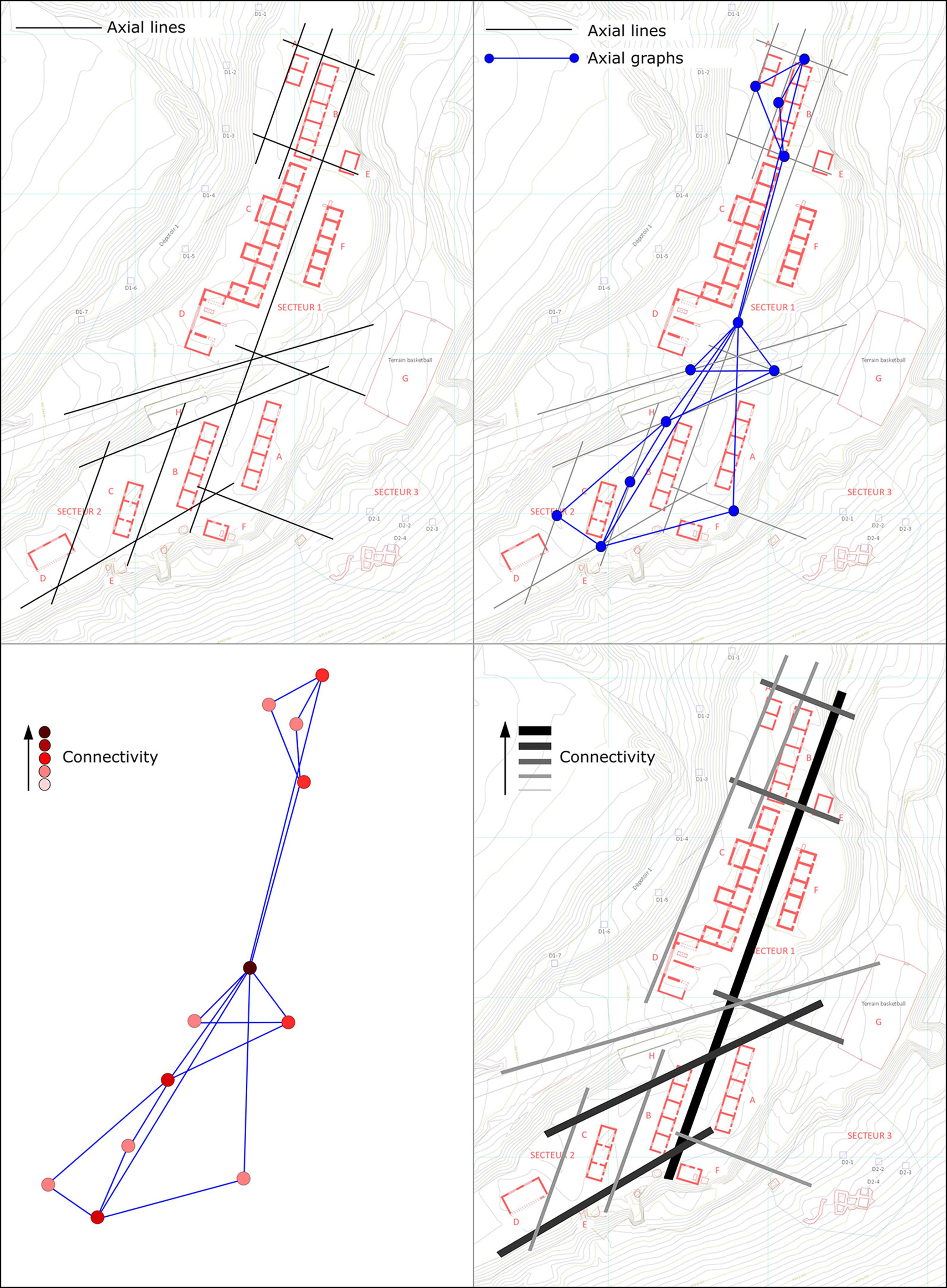
The analysis of mining camps and estancias shows how modernising policies materialised in terms of the space they were in. Analysing each site’s spatial organisation reveals social transformations generated by the irruption of capitalism and extractive industries in the region; the structural order of mining production is reflected in the distribution of spaces as structures of control and order. Spatial analysis of estancias and what we define as vernacular architecture shows distinct social groups moving on the margins of modern industrial spaces. This vernacular architecture is materialised through the use of local stone, constructions lacking standard measures and right angles, and a spatial distribution of enclosures and domestic spaces distinct from the rigid order of industrial mining camps (Figure 4). In sites such as Polapi, ethnographic data help us clarify this distinction, showing groups of Indigenous origin participating in the industry without being fully part of it (Figure 5). These groups remained on the margins, selling agricultural goods without being integrated as labourers in mining operations. Through different sources—interviews, material culture, architectural features—we identify several Indigenous families who refused integration as industrial mining wage labour. It is a refusal that enriches our understanding of twentieth-century labour history in peripheral Andean areas.
Axial analysis of Santa Cecilia mining camp showing the degree of connectivity of each site’s sector (figure by Francisco Rivera).

Industrial spaces and estancias in Polapi (figure by authors).

By identifying these persisting agropastoral practices on the margins of industrial sites, we can challenge long-held ideas of immediate structural changes, in which the Indigenous population would have modified their ways of life in a standardised, collective way, without exceptions. This evidence provides nuances for a common situation in industrial mining sites of the Central and Southern Andes: mining camps functioned as labour and a consumer-goods market supplied by the surrounding agricultural units and inter-regional trade networks. When industrial sites stabilised the labour market by employing a local and migrant labour force, demand for consumer goods followed, creating a new relationship between agropastoral and mining sites (Salazar-Soler Reference Salazar-Soler2002). Simultaneously, extractive mining activities generated a demand for capital that could be satisfied only through regional and global networks.
Deindustrialisation
Since the 1990s, with the closure of the sulphur mining industry, Ollagüe witnessed a process of deindustrialisation leading to the migration of its population to urban centres. This process cannot be understood in isolation and is entangled with national economic policies implemented by General Pinochet’s dictatorship (Gatica Reference Gatica1989). When mining camps closed, estancias were also abandoned, leaving a landscape of scattered ruins (Figure 6). Ollagüe became a deindustrialised landscape showing different temporal rhythms of ruination, challenging the modernisation project’s linear timeline based on economic progress.
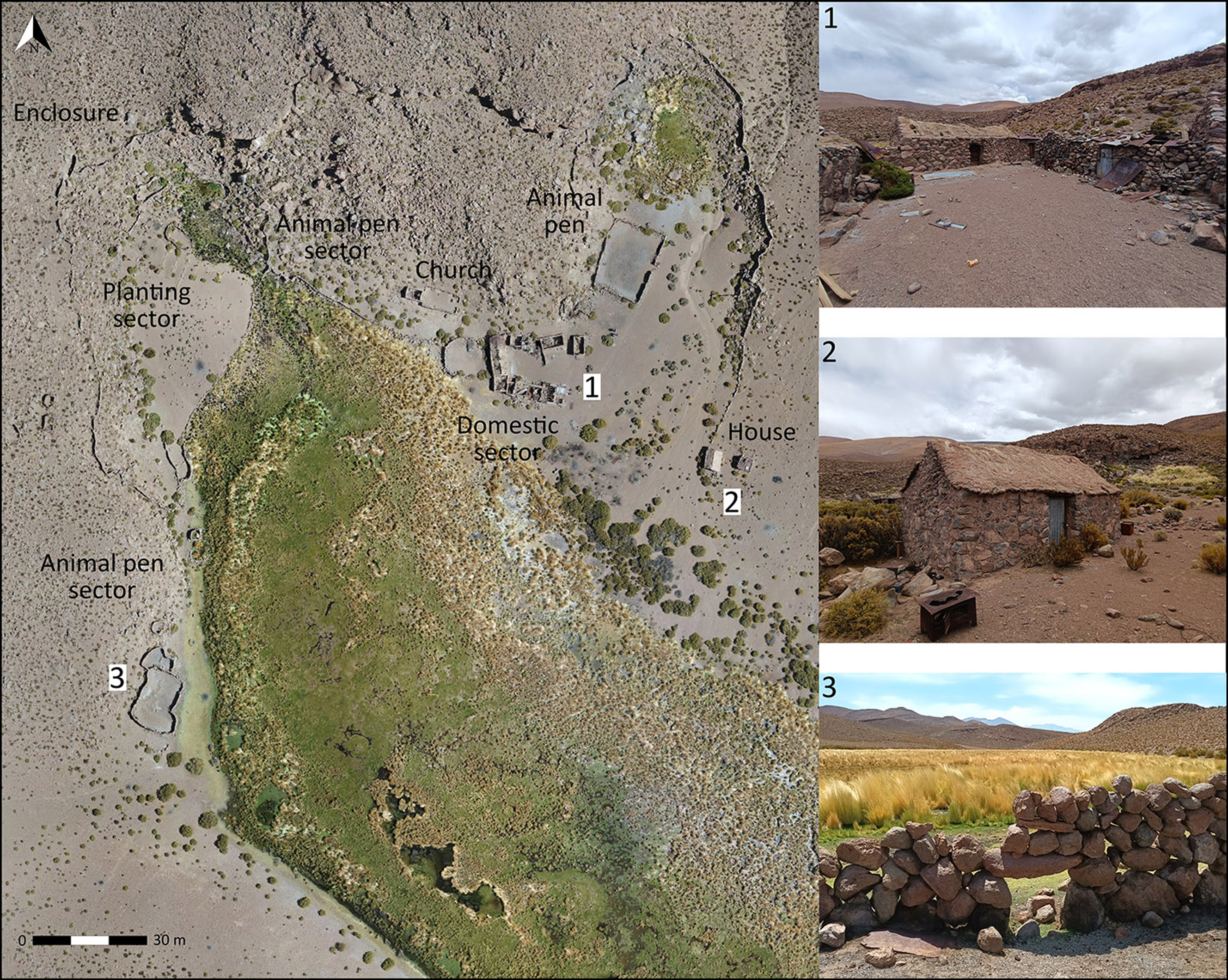
Caichape estancia: 1) view of the central space of the domestic sector, looking west; 2) rectangular stone house, located outside the perimeter wall; 3) detail of animal-pen stone wall (figure by Bernardita Pavez).

Conclusion
This project proposes a novel, contemporary and ethical approach to industrial archaeology as every methodological decision was taken in consultation with the Indigenous community of Ollagüe. The project is part of a long-term research programme aiming to advance the archaeology of the recent past and of modernisation in a region often seen as peripheral. Archaeological research in Ollagüe examined the materialisation of a new social order that still shapes the present in individual and collective memory. If industrial mining served the Chilean State as a form of control and integration of Indigenous territory into the State’s sovereignty, the closure and abandonment of industrial sites does not represent the end of modern social practices. Instead, Ollagüe’s industrial ruins offer ongoing responses to modernisation and capitalist expansion through new dynamics of cultural integration, such as State heritage policies and memory narratives (Rivera & Galaz-Mandakovic Reference Rivera and Galaz-Mandakovic2022). This perspective challenges the totalising and unidirectional vision of modernisation, putting forward its political ambivalence and, more importantly, the materialisation of deindustrialisation and its historical memory.
Acknowledgements
The Quechua Indigenous Community of Ollagüe.
Funding statement
ANID–FONDECYT Iniciación 11220113.


 Open access