


The old, very old man began to descend and the lower he went the younger he became.
—Fray Diego Durán, History of the Indies of New Spain (ca. 1588)
In prehispanic Mesoamerica, mountains loomed large not only on the landscape but also in cosmology and symbolism. They were understood as containers of sacred and vital forces, and as axes mundi, linking the heavens and the underworlds (e.g., Stuart Reference Stuart1997). Pyramids and other works of monumental architecture were equated metaphorically with such mountains, and edifices like the Pyramids of the Sun and Moon at Teotihuacan, the Great Pyramid of Cholula, and the Templo Mayor of Tenochtitlan became focal points of religious rituals, processions, pilgrimages, and peregrinations (e.g., Evans Reference Evans2016; López Austin and López Luján Reference López Austin and López Luján2009; McCafferty Reference McCafferty, Koontz, Reese-Taylor and Headrick2001). Understood as sacred mountains, or mountains of sustenance, in and of themselves, these human-made structures were woven into narratives of the genesis of the world and primordial origins, framing fundamental understandings of cosmology and history (e.g., Joyce Reference Joyce, Alt and Pauketat2020; Schele and Guernsey Kappelman Reference Schele, Kappelman, Koontz, Reese-Taylor and Headrick2001). As various pyramids fell into disuse and ruin, their facades eroded and they became overgrown, offering prehispanic observers views similar to that of the Pyramid of the Sun seen in an 1878 oil painting by Mexican artist José María Velasco (Figure 1). Here, the stark symmetry apparent in the pyramid and the Avenue of the Dead make it evident that the work’s primary subjects are largely anthropogenic, yet the passage of time has caused them to bleed with considerable ease into the general landscape of the Basin of Mexico. Processes of ruination further blurred what were already rather fuzzy boundaries between natural landscape features and human-built monumental edifices.
Pirámide del Sol en Teotihuacán, José María Velasco, 1878, oil on canvas. Instituto Nacional de Bellas Artes y Literatura, Mexico City. (Color online)

In the Mixtec highlands of Oaxaca, there was a relative dearth of monumental pyramids but no shortage of dramatically imposing mountains, and during the Postclassic period ruined remains of more modest sacred structures were frequently found at their peaks, creating similar confluences of natural and anthropogenic landscape, in turn evoking parallel historical and cosmological meanings. In this article, I aim to offer further perspective on the significance of such places, but less by way of examining these ruined mountaintop archaeological sites in of themselves and instead by looking at how people approached them and how they navigated to-and-fro between these summits and significant locales below. I will argue that this predominantly vertical movement, this ascent and descent between mountaintops and valley floors, was intrinsic to Mixtec engagements with sacred places and was undergirded by broader notions of Mesoamerican temporality. Moreover, ruins provided key nodes that framed these axes of vertical movement. As people traversed up and down, down and up, between places linked to the heavens, earth, and the underworld below, this potentially constituted a means of moving through time, between past, present, and future.
This article takes the Mixtec highlands as a poignant case study through which to consider the relationship between ruins and vertical movement in Mesoamerican cosmovision more widely. While navigating steep topography was a matter of daily course for prehispanic peoples in this region, the kinds of vertical journeys discussed here did not occur daily or by mere happenstance—they were planned and ritualized processions and pilgrimages, carried out at special times, with specific purposes in mind (Evans Reference Evans2016; Kubler Reference Kubler1984). I start this piece by looking at both the natural and political landscape here during the Postclassic period (ca. AD 900–1521), drawing from archaeological data and representations in the surviving Mixtec codices to suggest that various of the most prominent polities in the region owed their status in part to the fact that they were closely associated with ruins from earlier ages, which were understood by prehispanic Mesoamericans as “pre-sunrise” places (Hamann Reference Hamann2002). These places were bound up with understandings of sacred origins of the cult of the Feathered Serpent, or Quetzalcoatl, and the primordial genesis of the first Mixtec dynasties. I go on to pull the lens back and consider the locations of such places and how people traversed through them in a broader Mesoamerican perspective. Drawing from ethnohistoric and ethnographic evidence from central Mexico and the Maya region, I offer that, in certain moments, vertical movement up and down mountains could constitute a kind of “time travel,” or a means of contacting forces from the past in spaces in which time was condensed. I then move back to Oaxaca and look at the surviving Mixtec manuscripts more holistically, arguing that not only do creation narratives emphasize such movements up and down the landscape but also that the physical format and layout of the screen-folds serve to further accentuate this vertical movement. Drilling back down to a microregional view, I conclude by discussing routes of ritual procession taken in performances of the New Fire Ceremony at the site of Achiutla, arguing that traversing to and engaging with ruined sites on the landscape were not only motivated by concerns with the past but also with the future, and that ruins were integral features in processes of cosmic renewal.
Mountaintops and Ruins in the Mixteca Alta: Chiyo
For inhabitants of the highland Mixtec region, or Mixteca Alta, of Oaxaca during the Postclassic, abandoned ruins of the earlier Classic and Formative periods would have dotted many parts of the landscape. In an important study, Hamann (Reference Hamann and Blomster2008) has identified distinct conventions for naming and representing these features in early colonial historical records and prehispanic painted manuscripts. In sixteenth-century written sources, ancient places are known in Mixtec as chiyo yata—the term chiyo generally referring to “foundations” and yata qualifying them as “old” or “ancient.” In the pictorial codices, these foundations are typically rendered as architectural platforms, with staircases leading up them. Architectural platforms like these are commonly shown supporting temples and palaces that would have been in use during the Postclassic. What distinguishes the more ancient variety of chiyo in the codices is that these are shown without any superstructures standing atop them, as such structures would have collapsed by the time they were encountered by Postclassic observers. An interesting element of detail in the codices is that various foundations, both ancient and not, are shown with back-sloping facades topped by extruding rectangular panels typical of the talud-tablero style that was common in the Classic period and frequently associated with Teotihuacan.
Ruined architectural platforms or chiyo yata were frequently found atop mountains. Some of this is attributable to a tendency beginning in the Late Formative for political centers in highland Oaxaca to be concentrated in defensible positions, ostensibly due to the prevalence of warfare in the region (Joyce Reference Joyce2010:176–177; Kowalewski et al. Reference Kowalewski, Balkansky, Stiver Walsh, Pluckhahn, Chamblee, Pérez Rodríguez, Heredia Espinoza and Smith2009:297–304; Winter Reference Winter1989:37). In the Postclassic, there was a shift in settlement patterns, with centers more commonly found in the lower piedmonts. Abandoned hilltop sites nevertheless continued to be visited by people in later periods. Hamann (Reference Hamann and Blomster2008:136–137) illustrates how chiyo platforms in the codices are frequently depicted as sites of ancestor veneration and places where people made contact with supernatural beings. Archaeological evidence corroborates this picture of continued ceremonial use of previously abandoned sites in the Postclassic. Most notable is Tomb 7 found at the hilltop center of Monte Alban. The tomb was constructed as early as the Terminal Formative period (Martínez López Reference Martínez López, de la Cruz and Winter2002:227) but reentered and used as a site of ancestor veneration in the Postclassic, when hundreds of spectacular offerings of precious objects were deposited inside it (Caso Reference Caso1969; also see discussions in Jansen and Pérez Jiménez Reference Jansen and Jiménez2017; McCafferty and McCafferty Reference McCafferty and McCafferty1994). More limited evidence of Postclassic ceremonial revisitation of earlier abandoned centers is found at various sites throughout highland Oaxaca (Hamann Reference Hamann and Blomster2008:137; Joyce Reference Joyce2010:276; Spores Reference Spores1972:189).
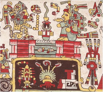
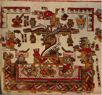
In part likely owing to their sacred associations, various of the most prominent Mixtec polities were located in close proximity to earlier hilltop archaeological sites. Most notable of these was Tilantongo, home to the preeminent ruling dynasty in the Mixteca, lying approximately 2 km to the northeast of the Terminal Formative mountaintop center now known as Monte Negro. While the identification of Tilantongo in the codices is quite clear, there has been some debate regarding the identification of this associated site of Monte Negro. There is not space enough to engage these debates fully here. In brief, various scholars (e.g., Byland and Pohl Reference Byland and Pohl1994; Geurds and Jansen Reference Geurds, Jansen, Mastache, Cobean, Cook and Hirth2008; Hamann Reference Hamann and Blomster2008; Jansen and Pérez Jiménez Reference Jansen and Jiménez2011:283–284; Pohl and Byland Reference Pohl and Byland1990; Smith Reference Smith1973:55–57) have linked Monte Negro to an explicit depiction of a black mountain capped with two chiyo yata foundations at its summit where two figures make ceremonial offerings, with the toponym for Tilantongo sitting at the mountain’s base on page 22 of the Codex Nuttall/Tonindeye (Reference Anders, Jansen and Pérez Jiménez1992; Figure 2).Footnote 1 This image also has a cognate on page 42 of the Codex Vienna (Reference Anders, Jansen and Pérez Jiménez1992), where a chiyo platform is depicted directly atop a black greca frieze associated with Tilantongo and shown immediately adjacent to other toponymic elements seen in the Nuttall/Tonindeye depiction.
Lady 1 Serpent and Lord 7 Death present sacrificial offerings while seated on ruined chiyo platforms atop the Black Mountain, or Monte Negro, in Codex Nuttall/Tonindeye (Reference Anders, Jansen and Pérez Jiménez1992:22). © Trustees of the British Museum. (Color online)

Hermann Lejarazu (Reference Lejarazu and Manuel2008, Reference Lejarazu, Manuel, Cicero and Paxton2017), has offered an alternative identification, based on a reading of information from the colonial Relaciones Geográficas from Tilantongo, where a “Hill of the Cicada,” or Chiquilitepeque, is described in the Relación as a mountain to the south of the community, which he links to a compound toponym referred to elsewhere in the literature as “Hill that Opens—Bee” that he then attributes to Monte Negro. The author suggests that the aforementioned Black Mountain depiction seen in the Nuttall/Tonindeye instead refers to the mound directly behind modern Tilantongo’s church, which he describes as an “archaeological site.” A difficulty with this interpretation has to do with the matter of ruins—while the mound behind the church is indeed an archaeological site today (see Byland and Pohl Reference Byland and Pohl1994; Geurds Reference Geurds2007), it was ostensibly occupied during the Postclassic and was unlikely to have been perceived as a chiyo yata at the time the codices were painted. In the manuscripts, while the Black Mountain is rendered rather dramatically as a ruined chiyo site, this is less evident in depictions of the “Hill that Opens—Bee.” Though on page 42 of the Codex Vienna (Reference Anders, Jansen and Pérez Jiménez1992) a chiyo platform sits directly atop the latter toponym (with an effigy vessel depicting the rain deity, or Dzahui, left as an offering atop it), in the Codex Nuttall/Tonindeye (Reference Anders, Jansen and Pérez Jiménez1992:19), a fully constructed and intact temple sits atop this same foundation. A further obstacle to this identification has to do with geography. In fleshing out his interpretation, Hermann Lejarazu (Reference Lejarazu, Manuel, Cicero and Paxton2017:137) cites an account from a nineteenth-century observer named Fidel López in the unpublished writings of Manuel Martínez Gracida. In it, a hill named Yucu Tnoo—Mixtec for Monte Negro—is described as where Tilantongo’s first church was built. Hermann Lejarazu takes this to imply that the name Monte Negro refers to the aforementioned mound behind the modern community’s church. A complication here is that López describes the hill in question as 464 m in height, an impossible figure for the relatively modest mound. Meanwhile, the elevation difference between Tilantongo’s church and the archaeological site now known as Monte Negro is approximately 470 m—almost certainly not a coincidence—pointing to the more parsimonious interpretation that the latter has been known as the Black Mountain and home to sacred hilltop ruins well back into prehispanic times. My own view is that the Black Mountain seen in the codices most likely refers to the archaeological site now known as Monte Negro, though Hermann Lejarazu may very well be correct that the “Hill that Opens—Bee” could also be located in the general vicinity of Tilantongo and that ancient chiyo platforms maybe have been found here as well (see Kowalewski et al. [Reference Kowalewski, Balkansky, Stiver Walsh, Pluckhahn, Chamblee, Pérez Rodríguez, Heredia Espinoza and Smith2009:68–76] for some potential candidates).
Other debates connected to this matter, such as whether the insect depicted in the glyph for “Hill that Opens—Bee” is in fact a bee, a fly, a cicada, a wasp, or another organism seem impossible to fully resolve (see Hermann Lejarazu Reference Lejarazu, Manuel, Cicero and Paxton2017:131–132; Jansen and Pérez Jiménez Reference Jansen and Jiménez2011:323–324). Entomological issues aside, what is clear under any interpretation is that Tilantongo was located adjacent to, and associated by Postclassic Mixtec peoples with, ancient ruins, and this fact appears to be emphasized in the codices. These ruins were associated with primordial creation in the Codex Vienna (Reference Anders, Jansen and Pérez Jiménez1992) and with the bringing of the cult dedicated to Lord 9 Wind (the Mixtec manifestation of the deity Quetzalcoatl) in the Codex Nuttall/Tonindeye (Reference Anders, Jansen and Pérez Jiménez1992). Such associations likely lent clout and prestige to Tilantongo’s ruling dynasties, enhancing their importance in regional politics. Other important Mixtec polities appear to have had similar associations. One of these is Coixtlahuaca, to the north of Tilantongo, an area of interaction between Mixtec, Chocho, and Nahuatl speakers. In several colonial manuscripts (see Brownstone Reference Brownstone2015; König Reference König2017; Parmenter Reference Parmenter1982; Rincón Mautner Reference Rincón Mautner1999; Van Doesburg Reference Van Doesburg2025), a story of origins and foundations in the region similarly culminates with the bringing of a sacred bundle dedicated to 9 Wind/Quetzalcoatl to a mountaintop, in this case a Mountain of Intertwined Serpents, also depicted at times as a Mountain of Sustenance. Most explicitly in the Selden Roll (Codex Selden 1964; Figure 3), this mountain is shown with a chiyo platform at its summit, on top of which the sacred bundle is placed. Here the toponym is formed by an elaborate anthropomorphized mountain with a quetzal bird enclosed by a circle at its center, with serpents adorned with clouds and flint knives wrapping themselves around it and feathers lining the mountain’s edges. The ruined chiyo platform atop it is rendered much more simply than is usually seen in the prehispanic manuscripts but is nevertheless unmistakable. The location of this mountain has been identified rather precisely by Rincón Mautner (Reference Mautner, Carlos and König2017:112–113, Reference Rincón Mautner, Mendoza and Hansen2024:132–134) as the hill known as Ndaga, or the Cerro de Torrecillas, in the north-central sector of the Coixtlahuaca Basin. It is unclear whether architectural platforms are visible on the surface here, but there is clear evidence of earlier human occupation in the vicinity (Kowalewski Reference Kowalewski2021; Rincón Mautner Reference Rincón Mautner1999).
Depiction of the Mountain of Intertwined Serpents, or Mountain of Sustenance, with the bundle dedicated to 9 Wind placed atop a chiyo platform at its summit, in the Selden Roll. The Bodleian Libraries, University of Oxford, MS. Arch. Selden. A.72 (3). (Color online)
Several other prominent Postclassic polities associated with the cult to 9 Wind/Quetzalcoatl were also associated with mountaintop ruins. One of these is Yanhuitlán, where the seventeenth-century friar, Francisco de Burgoa (Reference Burgoa1934:277), writes that important priests were charged with maintaining a shrine in a cave beneath a hill. The hill in question may have been Cerro Jazmín or, alternatively, Yucuñudahui, both of which are located nearby and are home to extensive archaeological sites dating as far back as the Formative period (Pérez Rodríguez and Martínez Tuñón Reference Pérez Rodríguez and Martínez Tuñón2019). Byland and Pohl (Reference Byland and Pohl1994:103) have linked Cerro Jazmín specifically with the toponym in the codices for Chiyoyuhu, located in the floor of the Nochixtlan Valley, and represented in the codices as a ruined chiyo topped by a tree with white flowers (also see Hamann Reference Hamann and Blomster2008:131; Jansen and Pérez Jiménez Reference Jansen and Jiménez2011:297–298). The toponym for Yucuñudahui, meanwhile, is not shown with a chiyo atop it but appears exclusively in narratives of primordial creation as an anthropomorphized mountain bearing the face of the rain deity Tlaloc, known in Mixtec as Dzahui, including a scene from page 47 of the Codex Vienna (Reference Anders, Jansen and Pérez Jiménez1992), where 9 Wind appears to stand at the hill’s summit, holding the sky and waters above it on his back.
The priests charged with tending to the shrine at Yanhuitlán resided at the site of Achiutla, described by Burgoa (Reference Burgoa1934:319) as the preeminent religious center in the region, home to a deity image or “oracle” known in Mixtec as the Ini Ñuu, or “Heart of the People,” to which people made pilgrimage from far and wide. It was purportedly of such renown that the last prehispanic Aztec emperor, Moctezuma II, sent emissaries there to receive a prognostication regarding the result of the encounter between the Mexica and Spanish conquistadors (Burgoa Reference Burgoa1934:277). This oracle was most likely a sacred bundle dedicated to 9 Wind/Quetzalcoatl (Jansen and Pérez Jiménez Reference Jansen and Jiménez2011:308). Though Achiutla has more frequently been associated by scholars with the solar deity known as Lord 1 Death (Byland Reference Byland and Blomster2008; Byland and Pohl Reference Byland and Pohl1994; Pohl Reference Pohl, Stanton, Taube, Coltman and Marengo Camacho2023), and a temple dedicated to that god was likely also located in the area, the entity regarded as the Heart of the People revered throughout the Mixteca was probably connected to the more important Mixtec deity of 9 Wind. Moreover, Burgoa (Reference Burgoa1934:332) describes the object that constituted the “oracle” as a large green stone decorated with carvings of a bird and serpent, evoking Feathered Serpent imagery.
Burgoa (Reference Burgoa1934) is quite specific in describing the location of Achiutla’s oracle—he states that it was found on the tallest hill in the community, atop its rough and overgrown eminence. This is a clear reference to a mountain now known as the Cerro de la Corona, or Hill of the Crown, referred to as such because its peak is ringed by vestiges of ancient defensive walls. It is popularly known in the modern community of Achiutla today as the site of the Postclassic oracle, and Kowalewski and colleagues (Reference Kowalewski, Balkansky, Stiver Walsh, Pluckhahn, Chamblee, Pérez Rodríguez, Heredia Espinoza and Smith2009:194) have dated the site to the Terminal Formative period in their survey of the broader region, while noting a substantial reoccupation in the Postclassic as well. A representation of this place has not yet been identified in the codices with certainty, though Jansen and Pérez (Reference Jansen and Jiménez2011:305) suggest a toponym seen on page 6 of the codex Selden may depict a cave atop Cerro de la Corona containing the Heart of the People. At the hilltop archaeological site, ruined early chiyo platforms are clearly still visible on the ground today (see Forde Reference Forde2015:118–119), though it is not entirely certain whether these ruins were constructed in the Terminal Formative period, or could have been built or remodeled later in time. Nevertheless, the importance of Achiutla’s oracle and the prominence of its priests likely owed in part to the Cerro de la Corona’s association with the distant past. The ruling dynasties at Tilantongo, Coixtlahuaca, and Yanhuitlán similarly drew some of their prestige from connections to ancient sites that were woven into narratives of primordial creation and foundation, to which they at times traversed from pointsbelow.
Highs and Lows, Peaks and Valleys: Water-Mountain
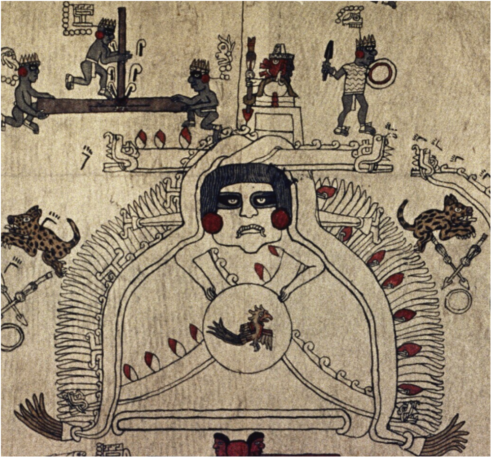
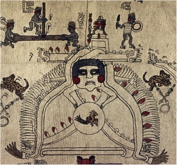
Mixtec manuscripts suggest that ruins were not only associated with mountaintops but also with the skies or heavens. In both the Codex Vienna (Reference Anders, Jansen and Pérez Jiménez1992) and Codex Nuttall/Tonindeye (Reference Anders, Jansen and Pérez Jiménez1992), we see chiyo platforms explicitly depicted in representations of the heavens or in celestial bands. In the opening sequence from the obverse side (page 52) of the CodexVienna (Reference Anders, Jansen and Pérez Jiménez1992), the creator couple known as Lady and Lord 1 Deer appear seated on chiyo platforms atop a sky band. Later in the narrative, on page 48, Lord 9 Wind is seen seated in a celestial realm receiving his ritual vestments, instruments, and temples, as well as instructions from two aged male lords on either side of him, prior to his descent on a rope adorned with feather down to the earth below. The lord on the left sits on a chiyo while his counterpart sits on a stone. In a parallel scene in the Codex Nuttall/Tonindeye (Reference Anders, Jansen and Pérez Jiménez1992; Figure 4), we see a celestial band that encloses around the previous sun (the “Movement Sun”) flanked on either side by the aged supernatural figures Lady 5 Serpent and Lord 4 House. Only the heads of these figures are shown, each atop a small platform or chiyo. In this narrative, it is an impersonator of 9 Wind, a Lord 12 Wind “Smoking Eye,” who descends from the sky to earth.
The heads of Lord 4 House and Lady 5 Serpent are depicted atop chiyo platforms flanking the “Movement Sun,” as visionary priest Lord 12 Wind “Smoking Eye” and attendants descend from the sky to the river of Apoala (left). Prior, people make ceremonial offerings at a large chiyo platform found in the bottom of a valley (right). Codex Nuttall/Tonindeye (Reference Anders, Jansen and Pérez Jiménez1992:17–18). © Trustees of the British Museum. (Color online)

Ruins of past civilizations and sites of primordial origins were not exclusively associated with places high in the sky, however. We also find them in locations well below. In the scene immediately prior to Lord 12 Wind’s celestial descent in the Codex Nuttall/Tonindeye (Reference Anders, Jansen and Pérez Jiménez1992) we see a large stack of burning offerings placed on a chiyo platform that sits in the base of a valley (Figure 4). When Lord 12 Wind then does descend from the heavens, he almost immediately arrives in Apoala, an important place associated with the creation of the first dynasties featured in the Codex Vienna (Reference Anders, Jansen and Pérez Jiménez1992) and Codex Nuttall/Tonindeye (Reference Anders, Jansen and Pérez Jiménez1992) codices and discussed in ethnohistorical sources. Depicted as a river in cross-section, with a human hand grasping or pulling feathers, it was known as Yuta Tnoho in Mixtec, the river from which the first lords were “plucked” (Smith Reference Smith1973:75). Another similar place of creation was the aforementioned site of Achiutla. Well beneath the mountaintop shrine dedicated to the oracle, in a river situated within the valley floor, we see the main glyph associated with the Postclassic community—Ñuu Ndecu, or “Place of Flame,” normally depicted as a greca frieze with red flames attached—topped with a sacred tree from which the region’s first rulers are born in the codex Selden (Figure 5). Important ancient sites with chiyo predating the Postclassic were likely far more common in valley floodplains of Oaxaca than is often appreciated currently by archaeologists, as these sites are more likely to be buried under alluvium and modern development than their mountaintop counterparts (Borejsza and Lohse Reference Borejsza, Lohse, Rodríguez, Morell-Hart and King2024; Leigh et al. Reference Leigh, Kowalewski and Holdridge2013).
A ruler is born from a sacred tree that emerges from a river valley at Achiutla, known as Ñuu Ndecu, or the “Place of Flames,” in Mixtec. Codex Selden, page 2. The Bodleian Libraries, University of Oxford, MS. Arch. Selden. A.2., Folio 2. (Color online)

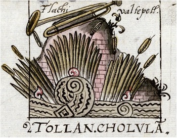
In certain places, the combination of mountaintop ruins associated with the heavens and watery places of origins below like Apoala and Achiutla may have created a dyad defining an axis mundi (López Austin and López Luján Reference López Austin and López Luján2009:40), and this perhaps becomes clearer if we widen our view to look at Mesoamerica more broadly. A recurrent concept in Mesoamerican cosmology going back millennia is manifested through the combination of mountain and water—altepetl in Nahuatl, yucunduta in Mixtec—or mountain and cave.Footnote 2 The juxtaposition of these topographic high and low points formed a complementary dualism, with clear implications for not only how people understood movement through space but also, I will argue, through time. A striking depiction of a water-mountain complex incorporating ruins is found in the colonial Relación Geográfica map of Cholula (Rojas Reference Rojas1927 [1581]; Figure 6). Here we see the name of the place given as Tollan Cholula (emphasis mine)—that is, as a Place of Reeds—indicating it is a place of creation. The swirling waters and sprouting cattail reeds or marsh-grass in the foreground almost obscure the mountain that rises behind it. Between the reeds, we can see that the mountain is composed of square bricks or faced with human-worked stones, undoubtedly evoking what were by this time ruins of Cholula’s Great Pyramid. The combination of the imposingly tall pyramid and the lush lowlands below explicitly references sacred origins and implies a relationship or movement between these places. The Great Pyramid was a major site of religious pilgrimage for people in prehispanic times, and its ruins continued to be so throughout the colonial period and into the modern day (Kubler Reference Kubler1984; Lind et al. Reference Lind, Daneels, Gutiérrez Mendoza, Daneels and Mendoza2012; McCafferty Reference McCafferty, Koontz, Reese-Taylor and Headrick2001; Olivera de Vázquez Reference Olivera de Vázquez1970).
Depiction of Tollan Cholula showing the Great Pyramid rising above swirling waters and cattail reeds in Cholula’s 1581 Relación Geográfica map (Rojas Reference Rojas1927 [1581]). Benson Latin American Collection, LLILAS Benson Latin American Studies and Collections, the University of Texas at Austin. (Color online)

The important confluence of sacred mountain and place of origin below goes much further back in time, at least to the Classic period at Teotihuacan. A most vivid illustration of this juxtaposition is seen in the Tepantitla murals, depicting a large bell-shaped mountain with a cleft or cave at its base, out of which waters flow, bringing plant growth. The mountain here might represent the Cerro Gordo at Teotihuacan, which is also metaphorically represented by the monumental Moon Pyramid in the site’s civic-ceremonial core (Cowgill Reference Cowgill2000:361; Headrick Reference Headrick2007:30). Similarly to Cholula’s Great Pyramid, the pyramids of Teotihuacan continued to be sites of pilgrimage, folded into Postclassic origin stories long after they fell into ruin (Heyden Reference Heyden1975; López Luján Reference López Luján1989; Umberger Reference Umberger1987:82–84). In the 1580 Relación Geográfica describing the community nearest to the ruins, San Juan Teotihuacan, the site is glossed in a map as the “Oracle of Moctezuma,” and it was said that this last prehispanic Aztec ruler, Moctezuma II, sent priests there every 20 days to make sacrifices (Paso y Troncoso Reference Paso and Troncoso1905:6:221–222). Here, ruins of the past, initially conceived as sacred mountains with places associated with primordial origins beneath them, were ostensibly visited not only because of concerns with the past but also out of an interest in interceding in the future.
Time Travel
Moctezuma II’s motivations for sending priests to Teotihuacan perhaps become clearer if we look at a similar action carried out by his predecessor and namesake, Moctezuma I, as recorded in the chronicle of sixteenth-century Dominican friar Diego Durán (Reference Durán1994), an account that is also highlighted in a discussion of Mesoamerican temporalities by Boone (Reference Boone2000:19–20). In it, Moctezuma I comes to understand that Coatlicue—mother of the Aztec patron deity Huitzilopotchtli—was still alive, residing in Chicomoztoc, the Place of the Seven Caves, which was found directly within or beneath a mountain known as Culhuacan, or the Bent Mountain. This mountain/cave was quite far away, adjacent to the Aztec’s mythical homeland of Aztlán, somewhere in the distant north, the latter an island in the middle of a lake. Culhuacan/Chicomoztoc lay just across the lake, on its shores. Moctezuma I wished to know this place and to make offerings to Coatlicue, and to do so, he enlisted 60 “sorcerers” (i.e., priests; Durán Reference Durán1994:214) to undertake a journey there. They took a most interesting route—they first traveled to another sacred mountain near to the Aztec capital of Tenochtitlan, Coatepec, which was also deeply associated with narratives of creation (Schele and Guernsey Kappelman Reference Schele, Kappelman, Koontz, Reese-Taylor and Headrick2001). Here they performed rituals to achieve shamanic trance and were then transformed into their nahuales, or animal spirit companions (Durán Reference Durán1994:214–215). In this manner they traveled Aztlán, where they resumed their human forms and met fishermen who transported them across the lake to the hill of Culhuacan, with Chicomoztoc inside (Durán Reference Durán1994:216).
The arrival at Culhuacan was rather jarring for, as Boone points out, Moctezuma’s priests found that time had passed much more slowly here than in in their central Mexican homeland, and they were repeatedly asked by residents of the Bent Mountain about the welfare of people who were said to have migrated to the Basin of Mexico several generations prior. These were people who, for the visitors, clearly would have long since been deceased. When the priests finally entered the cave within the mountain and met with the mother goddess Coatlicue, she asked them, “Tell me, do the elders who took my son away from here still live?,” to which they replied, “They are no longer in this world. They are all dead, we never knew them” (Durán Reference Durán1994:218). Coatlicue expressed confusion at the possibility that they had passed away so long ago, asking, “But what killed them? All their friends here are still alive” (Durán Reference Durán1994:218).
Things became more jarring still after the priests gave Coatlicue the offerings they had brought her and began to depart. When they exited the interior cave, they found themselves at the summit of the mountain, from which they proceeded to walk downslope. After they had descended a considerable ways, Coatlicue reemerged at the peak, calling out for them to stop, and to observe how people never grew old in this place. She brought out an elderly servant and sent him down the mountain to them, claiming, “By the time he reaches you he will be a very young man!” (Durán Reference Durán1994:220). Indeed, when he reached Moctezuma’s priests, he was said to have appeared 20 years old. He then went on to demonstrate how he could alternatively become older or younger by ascending and descending the slope. It is not clear, however, whether to walk upward always meant to become older and down younger. In the very next paragraph in Durán’s text (Durán Reference Durán1994:220), the servant then says that if an elderly man wished to become a boy again, he was to climb to the top.
The preceding account is quite unique, and it is not my intent here to use it as the sole basis to make sweeping arguments regarding how ancient Mesoamericans understood relations between movements through landscape and time. However, ethnographic evidence provides some support for the notion that these mountain/cave complexes were places where time was condensed, and phenomena akin to time travel were possible, at least under particular circumstances. To offer one example, Christenson (Reference Christenson and Staller2008) discusses cofradía ceremonies practiced amongst the Tz’utujil Maya of Santiago Atitlán in highland Guatemala. These ceremonies take place at mountain shrines, or in cofradía houses that embody these mountains, both of which are understood to be connected to sacred caves in the surrounding mountains known as Paq’alib’al, equated with the center of the world. It is likely worth mentioning here that one of the locations that people in the community indicate provides access to Paq’alib’al is a cave near Chuitinamit, a pre-Hispanic archaeological site (Christenson Reference Christenson and Staller2008:107). Residents of Santiago Atitlán recount various stories about miraculous happenings associated with these caves, including some which resonate closely with Durán’s description of the passage of time in Chicomoztoc. According to one of Christenson’s (Reference Christenson and Staller2008:105) informants, “Time is different in Paq’alib’al. When a person goes in he thinks he is there for only a few minutes, but he is really there for weeks or months. . . . A half hour is three months in Paq’alib’al.”
With time passing so much more slowly in places like Paq’alib’al and Chicomoztoc than in the normal realms of mortal humans, it perhaps then follows that visiting them—which inevitably required ascending and descending mountains—constituted a means of contacting the distant past. Christenson (Reference Christenson and Staller2008:119) writes of Tz’utujil mountain shrines and cofradía houses in Santiago Atitlán that “each is a place of origin in the sense that ritual activity conducted there opens a portal not only into sacred space, but also into sacred time. Participants in these ceremonies consider themselves to be present at the moment of first beginnings when their gods and ancestors set the pattern for the world’s existence.” For the Mixtec, Nahua, and other groups of the Postclassic, such vertical movements between mountaintop chiyo and important places below similarly opened portals into sacred time and allowed persons a means of accessing, interacting, and negotiating with forces of the primordial past. In doing so, we see an illustration of the argument made by Boone (Reference Boone2000:19) in an interpretation of Durán’s aforementioned account of the journey of Moctezuma’s priests to Culhuacan/Chicomoztoc: “The past and future do not seem to have been permanently closed to the Mexicans. These temporal states were separated from the present, true, but their bounding walls were porous to the extent that the past could be visited if approached correctly.” The direction of this approach, through these bounding walls, appears to have been predominantly vertical.
Ups and Downs in the Mixtec Painted Manuscripts
To better understand the significance of the kind of vertical movement described in the preceding text, it is worthwhile to return our attention to the surviving corpus of Mixtec painted manuscripts or codices. To this point, we have looked at depictions of individual toponyms in these documents. To shed light on the dynamics of movement between them, it is necessary to pull the lens back a bit and situate them within the wider contexts of the narratives in which they appear and the physical forms of the objects on which they are painted. To start, as will be obvious to specialists in the field, all these manuscripts were fashioned over long strips of animal hide that were then folded over as “screen-folds,” such that they were quite compact and portable. They could be opened rather simply, akin to the manner of a European “book,” whereby only two pages were visible at one time, or unfolded more extensively, revealing complete narratives or at least long spans of them simultaneously (Hamann Reference Hamann2004). Across these horizontally folded pages, space was further partitioned by red guidelines and the direction of narratives was organized in one of two primary ways: (1) in rows running horizontally across individual pages or pairs of pages or (2) in columns, moving up and down across the pages.Footnote 3 In both cases, the reading order was “zig-zag” or “boustrophedon,” alternating direction from one row or column to the next.
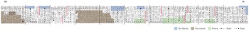
The two narratives that focus most specifically on events of primordial creation and foundation are found on the obverse sides of the Codex Vienna (Reference Anders, Jansen and Pérez Jiménez1992) and Codex Nuttall/Tonindeye (Reference Anders, Jansen and Pérez Jiménez1992), and the pages of both these manuscripts are divided into columns, rather than rows. This is perhaps no accident. Reading orders typically proceed from the bottom to the top, then down again. Johnson (Reference Johnson2005; see also Johnson Reference Johnson and Brownstone2015) has provided an extensive comparative analysis of the different spatial organizations of the surviving Mixtec painted histories. He points out that those divided into columns provide space for depicting and emphasizing vertical movements up and down the landscape (Johnson Reference Johnson2005:150, Reference Johnson and Brownstone2015:138–139). Extended movements between high and low places can be rendered in ways here that are virtually impossible in manuscripts organized into horizontal rows. Several examples could be used to illustrate this fact. Here, I will focus on the sequence extending across pages 14–22 of the Codex Nutall/Tonindeye (Reference Anders, Jansen and Pérez Jiménez1992), which centers on the figure of Lady 3 Flint and her daughter of the same name and their interactions with a visionary priest known as Lord 12 Wind “Smoking Eye,” whom we have already met, and who is shown in this sequence eventually bringing the sacred bundle dedicated to 9 Wind/Quetzalcoatl to the Mixteca. The pages here are read from right to left. As Johnson (Reference Johnson and Brownstone2015:139) points out, this section is dense with depictions of sky bands and rivers, and the artist was very careful to ensure that these always appear at the tops and bottoms of the columns in which they are respectively found (Figure 7). Here the columnar format allows for a dramatic rendering of repeated movements up and down the landscape. This includes Lord 12 Wind’s first descent from the sky to Apoala, as was discussed previously (Figure 4).
Diagram adapted from Johnson (Reference Johnson and Brownstone2015:139) showing locations of sky bands, rivers, and mountains on pages 14–23 of Codex Nuttall/Tonindeye (Reference Anders, Jansen and Pérez Jiménez1992). Image by Alfonso Valdés Maldonado. (Color online)

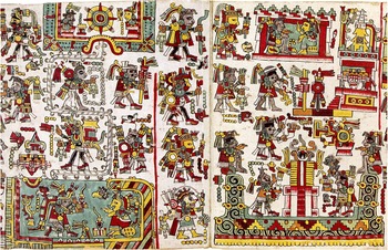
The columnar format also allows for something more—the division of pages with red guidelines can be periodically suspended, providing space for scenes to be rendered over multiple pages, as we see on pages 18–19 of the sequence. Here, following the descent of Lord 12 Movement “Smoking Eye” from a sky band, the ceremony of his marriage to Lady 3 Flint is depicted on an especially large representation of the previously discussed “Hill that Opens—Bee,” extending over both pages (Figure 8). The temple containing the sacred bundle dedicated to 9 Wind/Quetzalcoatl is placed near the summit of this mountain. Interestingly, the only other comparable scene in the surviving codices extending over multiple pages also depicts a large mountain range, on pages 9–10 of the Codex Vienna (Reference Anders, Jansen and Pérez Jiménez1992).Footnote 4 Johnson (Reference Johnson and Brownstone2015:139) suggests that this sequence, while typically read in pairs of pages, was likely fully unfolded on occasion, offering the viewer “a frieze-like representation of the vertical world.” Driving the narrative through this representation were descents from the sky and ascents up tall and extensive mountains. The timing of these events appears to have been quite deliberate. When Lord 12 Movement comes down from the sky and ascends the “Hill that Opens—Bee” with the 9 Wind temple, the date given is Year 7 Rabbit, Day 12 Wind; that is, this event occurs on his name day.
Depiction of the “Hill that Opens—Bee” as an extended mountain running across two pages, following the descent of Lord 12 Wind “Smoking Eye” (right) who carries the temple dedicated to 9 Wind/Quetzalcoatl up the mountain’s slope. Codex Nuttall/Tonindeye (Reference Anders, Jansen and Pérez Jiménez1992:19–20). © Trustees of the British Museum. (Color online)

Shortly after the depiction of the extended mountain, near the conclusion of this narrative, we see one last descent from the sky, this time not of Lord 12 Wind but instead of striped bodied supernatural figures or “cloud men” in a depiction of the War with Earth and Rain (Hamann Reference Hamann2002). After these figures are captured and sacrificed, there is a toponym of a Hill of the Rising Sun, where Lady 1 Death resides, and here a Lord 5 Crocodile “Bloody Eagle” leads Lord 12 Wind, the latter carrying the temple to 9 Wind/Quetzalcoatl on his back with a tumpline, to the hill’s summit, where the temple is then established (Figure 9). It is here that a new sun arises, marking the start of what was understood by Mixtecs in the Late Postclassic as the current age, depicted in the center of a celestial band above the temple on the hill as the “Skull Sun” (see Hamann Reference Hamann2002:360–361). Again, the timing is important—the date given is Year 1 Reed, Day 1 Crocodile, the start of the 52-year ritual cycle and a date used metaphorically in the codices to refer to “beginnings” (Furst Reference Furst1978). This date was associated with a ritual known as the New Fire Ceremony, carried out every 52 years and designed to reenact the birth of the sun (Jansen and Pérez Jiménez Reference Jansen and Jiménez2017:530).
Lord 12 Wind “Smoking Eye,” led by Lord 4 Crocodile “Bloody Eagle,” carries the temple dedicated to 9 Wind/Quetzalcoatl to the summit of the Hill of the Rising Sun, associated with Achiutla by various scholars. Above, the new age or sun, Codex Nuttall/Tonindeye (Reference Anders, Jansen and Pérez Jiménez1992:19–20). © Trustees of the British Museum. (Color online)

Various scholars (Byland Reference Byland and Blomster2008; Byland and Pohl Reference Byland and Pohl1994:187–189; Hamann Reference Hamann2002:359–360; Pohl Reference Pohl, Stanton, Taube, Coltman and Marengo Camacho2023) have identified the above Hill of the Rising Sun toponym as associated with the site of Achiutla. This identification makes sense in light of the community having been described as the most important religious center in the region, likely centered around the cult to 9 Wind/Quetzalcoatl, as discussed previously. Moreover, it makes some sense geographically. On the next page, we see Lord 12 Wind again carrying the temple with a tumpline up a large mountain, this time to Tilantongo, where it sits at the foot of the Black Mountain that we looked at earlier in this article. The date given once again is Year 1 Reed, Day 1 Crocodile, emphasizing a new beginning. Here, the presence of the temple is important in lending legitimacy to the first dynasty established in the community. Achiutla is located rather near to Tilantongo but over an incredibly imposing mountain range to the west. The connection between the communities might also be suggested by Burgoa’s (Reference Burgoa1934:275–276) description of an early colonial cacique of Tilantongo, don Felipe de Austria, making pilgrimage to Achiutla as part of his rites of confirmation, a journey over these imposing mountains, perhaps reminiscent of that undertaken by Lord 12 Wind in the Codex Nutall/Tonindeye (Reference Anders, Jansen and Pérez Jiménez1992) sequence. In the latter, vertical movement between places containing prominent ruins of the ancient past culminates in an act of renewal, the establishment of a new cosmic order. Don Felipe, in traveling a similar path in making the trek to Achiutla, may have sought in part to reenact this episode of primordial foundation.
Ascent and Descent in the New Fire Ceremony at Achiutla
The significance of ruins at Achiutla and their place in paths of vertical movement bringing about a new dawn might be further clarified if we fast-forward to 1937, when a journalist visited the town and wrote about it for the Mexican tourist magazine, Oaxaca en México. The author, Emiliano C. Gómez (Reference Gómez1937:8), claims to have “broken the silence” of elderly Mixtecs in the community, who then proceeded to recount in vivid detail how what was known as the New Fire ceremony was practiced in Achiutla in late prehispanic times. According to the journalist Gómez (Gómez Reference Gómez1937), all members of the community—including the caciques, nobility, and rulers of allied polities—first congregated in the center of the community, now known as the Pueblo Viejo. A high priest and three subordinates (ostensibly a council of four priests; see Pohl Reference Pohl1994) would then lead a procession up a mountain; however, not to the aforementioned ruin of the Cerro de la Corona but a second early site also found on a different nearby mountaintop, this one to the north and known as the “Casa del Sol,” or “House of the Sun” (Figure 10). At the summit of this mountain are remains of major works of prehispanic architecture, including a large collapsed mound with vestiges of a vaulted chamber conserved and dated to the Classic period, or AD 200–900, by Kowalewski and colleagues (Reference Kowalewski, Balkansky, Stiver Walsh, Pluckhahn, Chamblee, Pérez Rodríguez, Heredia Espinoza and Smith2009:195–196; see also Forde Reference Forde2015:120–122; Pohl Reference Pohl, Stanton, Taube, Coltman and Marengo Camacho2023:211–213). Pohl and Byland (Reference Pohl and Byland1990:126; see also Byland Reference Byland and Blomster2008; Pohl Reference Pohl, Stanton, Taube, Coltman and Marengo Camacho2023) have connected this site to a place described by Castellanos (Reference Castellanos1910) as near Achiutla called Yucu Gandi, or Yucu Ndicaandi, meaning “Hill of the Sun,” and associated it with the toponym of the Hill of the Rising Sun described in the preceding text in the Codex Nuttall/Tonindeye (Reference Anders, Jansen and Pérez Jiménez1992).
Trajectory of the ritual procession of the New Fire Ceremony at Achiutla, as described by Gómez (Reference Gómez1937). The starting point was the center of the prehispanic community, now known as the “Pueblo Viejo,” proceeding to the mountaintop archaeological sites of the Casa del Sol and the Cerro de la Corona. Satellite imagery © Google Earth. (Color online)

After spending the entire night at the Casa del Sol performing various rights, the processional group would then travel back into the valley, cross the river, and subsequently ascend the Cerro de la Corona, home of the ruins where Achiutla’s oracle was said to be found. It was here that, after a number of other ceremonies were performed, the new fire was eventually created, and, after lighting torches in this fire, people descended back into the community and relit the fires within their homes, in the river valley where the first rulers of the Mixteca were born from a sacred tree (Gómez Reference Gómez1937:9–10). This site of Cerro de la Corona was likely associated with the presunrise past, but visiting ruins here also provided a means of interceding in the future, and the oracle that was reported by the colonial friar Burgoa to have been kept here was explicitly understood to have provided prognostications of this future. As Christenson (Reference Christenson and Staller2008:119) describes for the Tz’utujil Maya, it was perhaps also the case for the Mixtec that engaging the distant past provided a means of witnessing the moment when the pattern of future events was first set into motion and of understanding that pattern. Intrinsic to achieving this was movement—reprising the kinds of dramatic ascents and descents initially undertaken by deities or deified ancestors in primordial history.Footnote 5
Seen most explicitly in the preceding historical account from Achiutla but suggested in various other representations of important Postclassic Mixtec places that have been considered over the course of this article, the ascent and descent from mountaintop ruins to important places on the landscape below brought past, present, and future into copresence. Processions and pilgrimages connecting places on the landscape associated with the presunrise past were integral to efforts of cosmic renewal. Was ascending a mountain to visit the ruins of previous ages a means of traveling back in time and descending it a means of moving into the future; or was maybe the opposite instead the case, a relationship that we saw become confusing in Durán’s account of the Aztec journey to Chicomoztoc? Within a cyclical conception of time, this difference is perhaps immaterial because just as in the case of the ritual procession of the New Fire ceremony, in the end, we always wind up back at the same place in which we started and, perhaps, at the same time. As with the sustenance of the sun, that had to be kept in constant motion, rising and setting each passing day, the key here to interaction with ruins on the landscape, and by extension time, might have less to do with directionality than with the simpler imperative that everyone keep moving, up and down, down and up.
Acknowledgments
Versions of this article were first presented at the International Medieval Congress in Leeds and the meeting of the Society for American Archaeology in Portland, Oregon, both in 2023. I thank the organizers and participants of both panels for their engagement and feedback, and Art Joyce and Roberto Rosado for subsequently inviting me to publish the article in this special section. I also thank three anonymous reviewers for their comments on this paper.
Funding Statement
No funding was acquired for the research that led to this publication.
Data Availability Statement
No original data were used.
Competing Interests
The author declares none.


 Open access