


Introduction
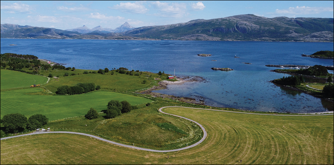
Monumental burial mounds, measuring up to 30–80m in diameter, are found throughout Northern Europe, particularly Scandinavia. Some of these contain ship burials, as at Sutton Hoo, near Woodbridge in England, and Oseberg, near Tønsberg in Norway. Herlaugshaugen (Figure 1) is one of Norway’s largest burial mounds, located on a small island off the coast of Namdalen. A myth recorded in Snorri Sturluson’s thirteenth-century saga of King Harald Fairhair (who may have reigned AD 872–930) identifies this mound as the burial place of the Viking Age king Herlaug. This myth prompted excavations in the eighteenth century, the findings from which were alleged to confirm Sturluson’s narrative. New excavation in 2023 by archaeologists from the Norwegian University of Science and Technology (NTNU) University Museum and Trøndelag County and radiocarbon dating of recovered wood samples now reveal that the Herlaugshaugen mound represents a ship burial dating to the end of the seventh or the beginning of the eighth century. This discovery is of great significance to Norwegian prehistory, where monumental ship burials have traditionally been associated with the onset of the Viking Age (c. AD 800–1050). Moreover, it provides a chronological bridge between the early seventh-century ship burials of Anglo-Saxon England (Carver Reference Carver2017), and Norway’s famous late-eighth- and ninth-century ship burials (Bonde & Stylegar Reference Bonde and Stylegar2016).
Herlaugshaugen (in the centre foreground) from the west, looking towards the strait and the mainland in the background (photograph by Hanne Bryn, NTNU University Museum, Norwegian University of Science and Technology).

Figure 1 Long description
The image presents a scenic landscape view featuring the Herlaugshaugen burial mound prominently in the center foreground. A winding road curves around the mound, leading towards it. The surrounding area is covered with lush green fields and scattered trees. In the background, a large body of water, likely a strait, stretches out towards the mainland, which is visible in the distance. The mainland is characterized by rolling hills and mountains under a partly cloudy sky.
Herlaugshaugen also adds to the corpus of research on monumentality as it can be categorised as a monumental ship burial (Bill Reference Bill and Skre2020). Bradley (Reference Bradley2024) links monumentality to periods of political change; many monuments derive their strength from an association with the past, and mounds might be seen as expressions of status and territorial claims. This article situates Herlaugshaugen and the island of Leka as a node in a regional network that also connected the coast of Trøndelag with a larger network reaching the continent.
Burial mounds and ship burials
Burial in ships and boats (see Bill Reference Bill and Skre2020 and Sørensen Reference Sørensen2001: 16–17 for a discussion of sizes) is a common phenomenon across Northern Europe, occurring from the first to the eleventh centuries AD. Details of 230 examples were catalogued in 1970 (Müller-Wille Reference Müller-Wille1970) and the number identified has risen significantly since. In a broader European context, boat and ship burials span from Brittany via East Anglia in the west to the Volga in the east and are predominantly associated with peoples of Nordic identity. Although the vessels vary in size (a boat longer than 12–15m is usually defined as a ship) and diversity in ceremonial customs is apparent, the practice seems to originate in a common belief in watercraft as an integral part of society, tying into power relations as well as ritual and religious life (see Brookes Reference Brookes2007; Bill Reference Bill and Skre2020).
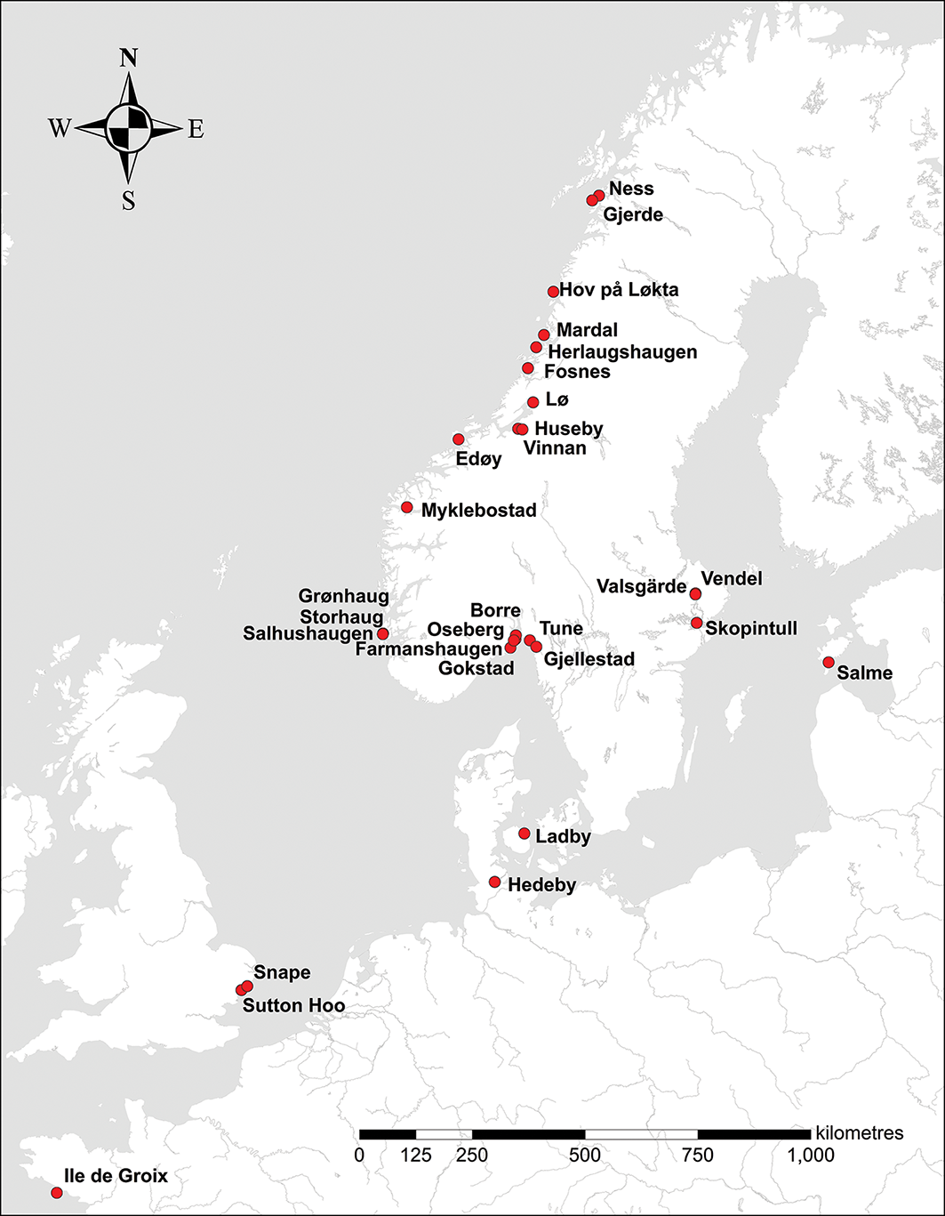
The earliest known Northern European boat burials are found in Scandinavia and date from the period AD 1–550 (Müller-Wille Reference Müller-Wille1970: 42–45; Crumlin-Pedersen Reference Crumlin-Pedersen and Andersen1991: 230, 245–47). Numbers increased during the Merovingian period (AD 550–800), with the rich boat burials from Vendel and Valsgärde in Uppland serving as prominent examples (Stolpe & Arne Reference Stolpe and Arne1912; Gräslund & Ljungkvist Reference Gräslund, Ljungkvist and Boye2011). The oldest known ship burials are from eastern England: the Snape cemetery (AD 550–600) and Sutton Hoo (AD 600–625) (Bruce-Mitford Reference Bruce-Mitford1952; Carver Reference Carver2005). Previously, the oldest Scandinavian ship mounds were found on Karmøy in western Norway, dating to the late eighth century (Bill Reference Bill and Skre2020). Two older ships were recently recovered in Salme, Estonia, but these were not regular ship mounds, rather the remains of a crew that had met a violent end around AD 750 and were subsequently buried in a ship (Lõugas & Luik Reference Lõugas and Luik2023). Other ship graves date from the ninth and tenth centuries, with a concentration in the Oslo fjord region (Bill Reference Bill and Skre2020; Paasche Reference Paasche2024) (see Figure 2).
Ship burials mentioned in the text (illustration by Ragnheiður Traustadóttir, Antikva).

Figure 2 Long description
The map displays various locations in Scandinavia and surrounding regions where early Northern European boat burials have been found. Key locations marked on the map include Ness, Gjerde, Hov pa Løkta, Mardal, Herlaugshaugen, Fosnes, Lø, Husby, Vinnan, Edøy, Myklebostad, Grønhaug, Storhaug, Salhushaugen, Farmanshaugen, Borre, Oseberg, Tune, Gjellestad, Gokstad, Valsgärde, Vendel, Skopintull, Salme, Ladby, Hedeby, Snape, and Sutton Hoo. These sites are indicated with red dots and span from western Norway to eastern England, covering significant historical periods from AD 1550 to the ninth and tenth centuries. The map provides a geographical context for understanding the distribution and historical significance of these boat burials.
Ship burials have often been interpreted as expressions of power and social status tied to origin myths, largely based on perceptions of pagan kingship and regional control manifested through monumentality (Carver Reference Carver2005: 489–503; Bonde & Stylegar Reference Bonde and Stylegar2016; Bill Reference Bill and Skre2020; Gustavsen et al. Reference Gustavsen2020). Watercraft graves are also understood as ritual manifestations linked to mythology, religion, fertility and the transformative journey to the realm of death (Brøgger et al. Reference Brøgger1917; Müller-Wille Reference Müller-Wille1970: 126–41; Crumlin-Pedersen Reference Crumlin-Pedersen and Andersen1991, Reference Crumlin-Pedersen, Munch Thye and Crumlin-Pedersen1995; Klevnäs Reference Klevnäs2015), while the material remains themselves have been crucial for reconstructing vessel design and maritime traditions during the seventh–tenth centuries (Bischoff & Bill Reference Bischoff and Bill2023; Sørensen Reference Sørensen2001). Though Herlaugshaugen can contribute to scholarly understanding on all these fronts, this article is primarily concerned with its links to myth and the creation of a monument.
Traditionally, the Norwegian ship graves and other large mounds have been linked to the sagas and especially to the rise of the Yngling dynasty (the dynasty of the first Norwegian kings; according to Snorri Sturlusson, the dynasty starts with the god Freyr) (Brøgger & Shetelig Reference Brøgger and Shetelig1950). Discussions revolved around which of the saga kings were buried in the various mounds. Later, with radiocarbon dates showing that the western Norwegian ship graves were older than the Eastern Norwegian ship graves, these were seen as having been inspired by tales from Anglo-Saxon areas, part of a ‘package’ or template for how emerging clans with royal ambitions could distinguish themselves (Bonde & Stylegar Reference Bonde and Stylegar2016). Jan Bill (Reference Bill and Skre2020) sees ship mounds in western Norway as inspired by Anglo-Saxon ship graves and as a new political configuration linked to an origin myth for rulership. As such, ship graves were an instrument for transferring power from one ruler to another. Lars Gustavsen and colleagues (Reference Gustavsen2020) similarly interpret ship graves as indicative of a period of contested land ownership driven by rivalry and competition among dynastic clans. Recent research on the Gjellestad ship burial site highlights the presence of trade and indicators of political power expressed in the monumental structures and metal detector discoveries, and the site’s potential function as a ‘thing’ (a place for governing assemblies), signifying elite dominance over a territory. The construction of a ship mound evidently served as a means of linking and manifesting power within a predefined landscape (Paasche et al. Reference Paasche2024).
Herlaugshaugen: research history
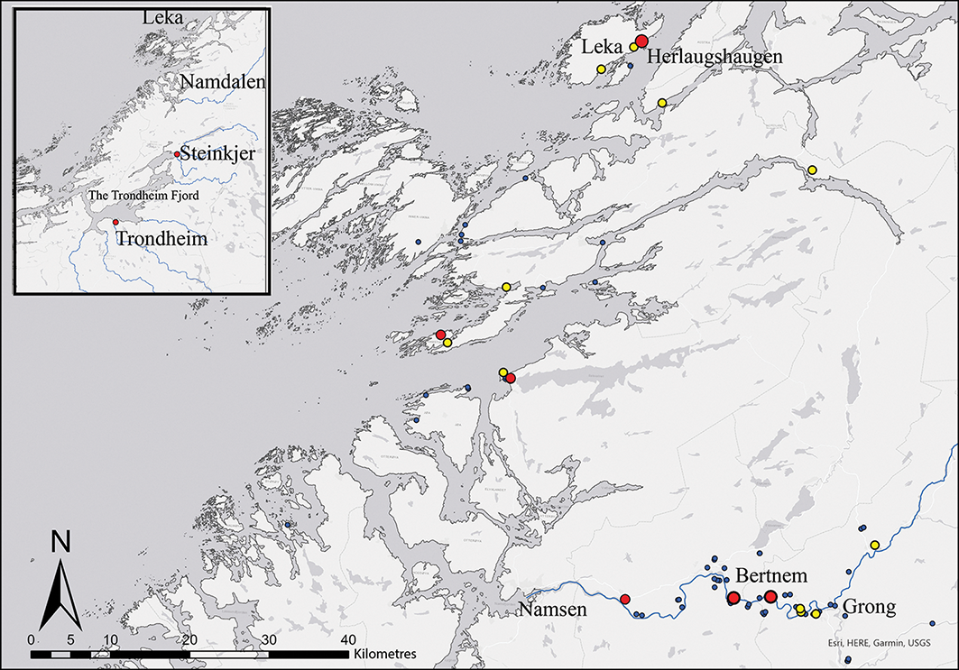
Leka is a small island on the coast of Namdalen (Figure 3) in the northern part of Trøndelag. Herlaugshaugen sits on the east of the island, facing the mainland. Namdalen consists of the outer coast and the valley along the river Namsen. The valley runs west towards the coast from Grong. Thus, an east–west-oriented land/river route meets the north–south sea route along the coast. Namdalen has relatively little agricultural land but is rich in natural resources such as fish and sea mammals and has extensive forested areas with a wealth of game, timber and bog iron ore. Together with the innermost part of the Trondheim fjord to the south, Namdalen has a dense concentration of boat burials, mostly with date ranges from c. AD 700–1050 (Herstad Reference Herstad2007: 35), and monumental mounds (Forseth Reference Forseth and Doerr2019: 373) (Figure 3).
Map showing Namdalen and the locations of places mentioned in the text. The dots are burial mounds with diameters of >50m (larger red), >40m (smaller red), >30m (yellow) and >20m (blue) (illustration by Geir Grønnesby, NTNU University Museum, Norwegian University of Science and Technology).

Figure 3 Long description
The map displays Scandinavia, focusing on the Namdalen region and the Trondheim Fjord. It marks various locations with colored dots representing burial mounds of different diameters: larger red dots for diameters over 50 meters, smaller red dots for diameters over 40 meters, yellow dots for diameters over 30 meters, and blue dots for diameters over 20 meters. Key locations such as Leka, Herlaugshaugen, Steinkjer, Trondheim, Bertnem, Namsen, and Grong are labeled. The map includes an inset showing the broader context within Scandinavia, with a focus on the regions of Namdalen and the Trondheim Fjord.
The myth rendered in the saga of Harald Fairhair has made the mound of Herlaugshaugen the subject of antiquarian attention. It describes how the brothers Herlaug and Rollaug, kings in Namdalen, built a large mound. To escape submitting to King Harald, a semi-mythical unifier of Viking Age Norway, Herlaug entered the mound with a large amount of food and sealed it behind him. Rollaug submitted to Harald. In the eighteenth century, the legend prompted the antiquarian Gerhard Schøning to have the mound examined (Suhm Reference Suhm1784). It was excavated during three campaigns, in 1755, 1775 and 1780. During the first excavation, local farmers found a deep hole in the middle of the mound and interpreted it as an air vent. They also found parts of a brass cauldron with engravings, which the farmers later remelted into shoe buckles.
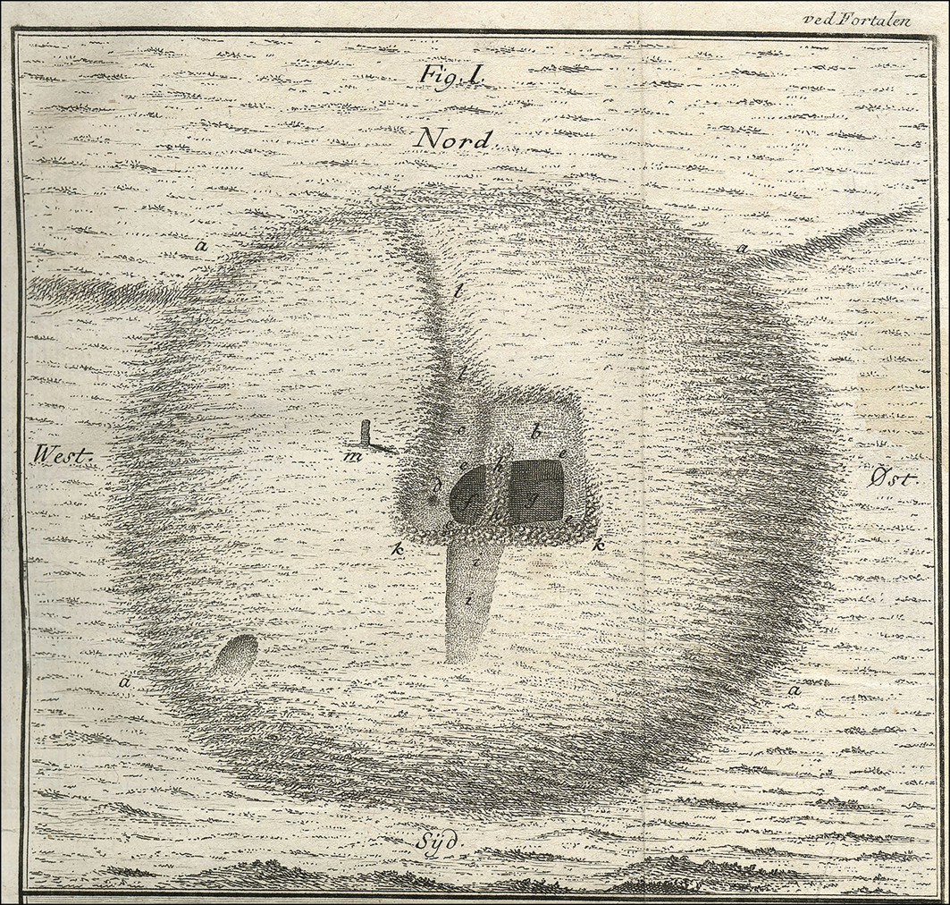
Lieutenants M. Lehne and P. H. Sommerschild led the subsequent excavations in 1775 and 1780. A letter from Lehne to Major General von Krogh describes both the 1755 and 1775 excavations, providing an account of the work and finds (Nicolaysen Reference Nicolaysen1868), and Sommerschild’s descriptions and drawings from 1880 are reproduced in Historie af Danmark (Suhm Reference Suhm1784) (Figure 4).
Drawing of Herlaugshaugen mound by P.H. Sommerschild, 1780 (published in Suhm Reference Suhm1784). The letters mark different places of discovery: d) the ‘air-vent’; h) wall of boulders; g) skeletons and sword. North on the map is actually north-east.

Figure 4 Long description
The drawing depicts the Herlaugshaugen mound with various labeled archaeological features. The labels include 'd' marking the air-vent, 'h' indicating a wall of boulders, and 'g' showing the location of skeletons and a sword. The orientation of the map is noted to be north-east rather than true north. The drawing is attributed to P.H. Sommerschild from 1780 and was published in Suhm 1784.
Sommerschild documented the mound as 63m in diameter and 7–8m high. Initial excavations were conducted at the centre of the mound. Two layers of charcoal were encountered just below the surface and, at a depth of almost 2m, the excavation team hit brown earth containing iron nails and a wall of boulders (Figure 4: labels h and k). About 4m below the surface, they found a stone slab covering a skeleton. Sommerschild interpreted this as the remains of an individual who had been leaning against a stone slab by the stone wall, which were then covered by the slab when it fell over. Beside the skeleton lay a sword. Slightly further south, parts of another skull and other human bones were found. Many animal bones, including cattle, pigs and sheep, and wooden beams with iron nails were also found.
The finds were interpreted as confirmation that King Herlaug’s storeroom, and thus his grave, had been located. The sword and the skeleton were taken to Trondheim but unfortunately they were lost at the beginning of the twentieth century (Petersen Reference Petersen1917). The mound was not interpreted as a ship burial until 1917, when Theodor Petersen reinterpreted the mound as a ship burial and the ‘air vent’ as the imprint of a mast.
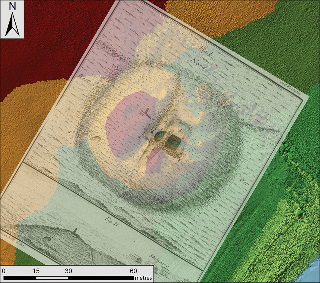
In 2012, aerial photographs and a high-resolution lidar dataset (5-point per m2) obtained from the site were compared with a georeferenced version of Sommerschild’s drawing (Figure 5) (Stamnes Reference Stamnes2015). The maximum preserved diameter of the mound was measured at 62m. By comparing data from lidar, ground-penetrating radar and earth resistivity surveys with stratigraphic descriptions, it was estimated that the mound was 12.5m tall and encompassed by a ditch that was 5–8m wide and reached down to depths of 1m in places in the subsoil (Stamnes Reference Stamnes2015).
Sommerschild’s map from 1780 georeferenced over lidar data from 2012 (from Stamnes Reference Stamnes2015: fig. 7; illustration by Arne Anderson Stamnes, NTNU University Museum, Norwegian University of Science and Technology).

Figure 5 Long description
The image displays a historical map from 1780 georeferenced and overlaid on modern lidar data from 2012. The map shows various geographic features and locations, with the lidar data providing a detailed topographic context. The overlay highlights changes and continuities in the landscape over time, offering insights into historical geography and archaeological sites.
The excavation
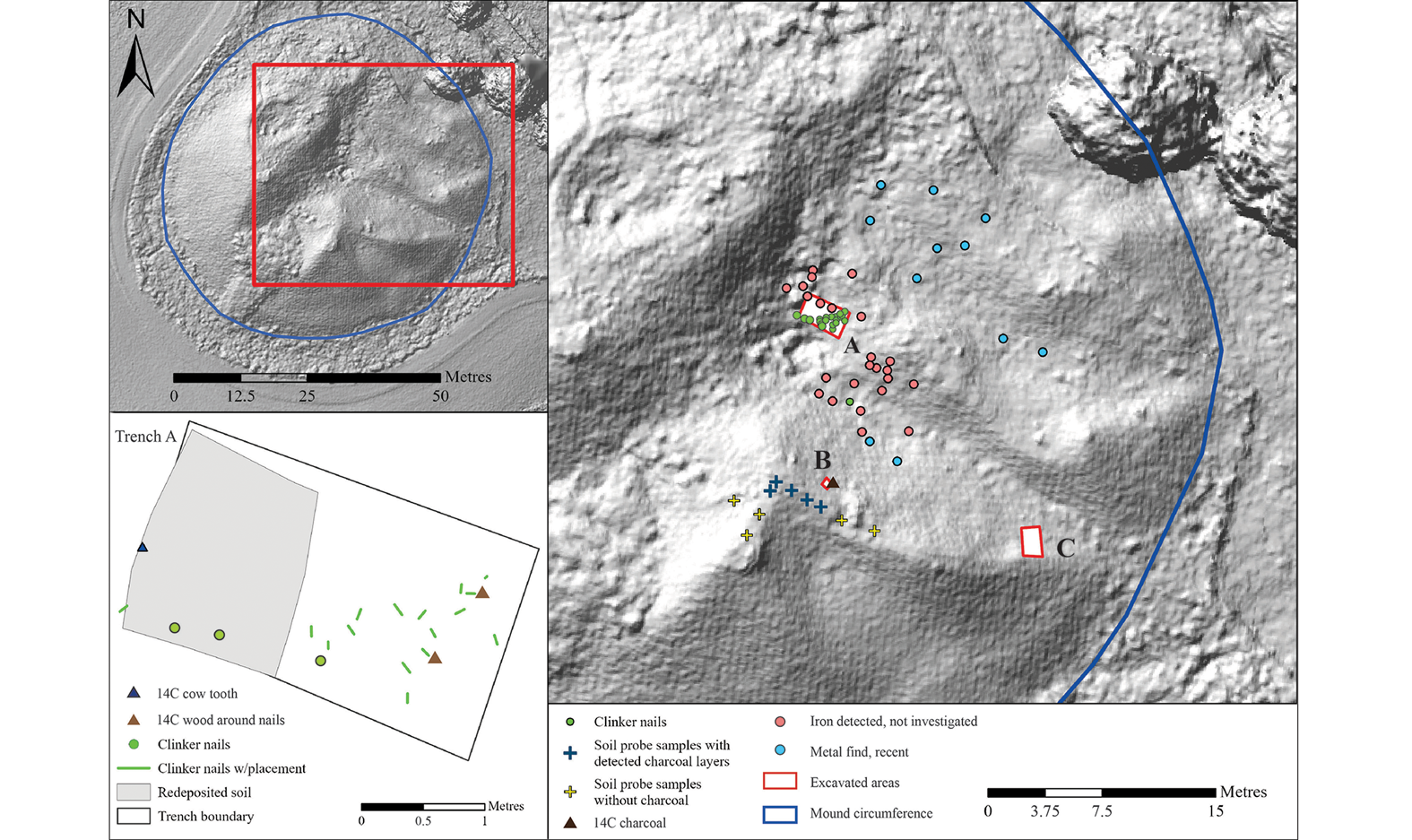
In 2023, a new excavation began; it had two objectives: to retrieve artefactual evidence for a ship and to collect samples for radiocarbon dating to provide dates for the mound’s construction. The excavation targeted three areas of the mound. A 2 × 1.2m trench was dug near the mound’s outer edge (trench C in Figure 6) to document its general structure and to identify the original ground surface. A test pit (B) was dug in the undisturbed upper part of the mound to a depth of approximately 1m to document the two charcoal layers identified in previous excavations and the soil probes. The detection of the charcoal layers proved consistent with Sommerschild’s observations. Finally, to identify possible remains of a ship, a 3 × 1.8m east–west-oriented trench (A) was dug just east of the stone wall at the centre of the mound. A metal detector was used within the trenches and surrounding areas.
Digital elevation model of Herlaugshaugen: right) location of the excavated areas in the central and south-eastern sections of the mound; A) the trench at the centre of the mound where iron rivets were found; B) test pit where layers of charcoal were documented; C) trench in the outer section of the mound documenting its general construction. Excavated metal finds from recent activity are marked in blue. Unexcavated iron detections are marked red: lower left) plan of the central trench (A) showing the placement of clinker nails (illustration by Hanne Bryn, NTNU University Museum, Norwegian University of Science and Technology).

Figure 6 Long description
The image presents a digital elevation model of Herlaugshaugen, highlighting the location of excavated areas in the central and south-eastern sections of the mound. Key areas include trench A at the center of the mound where iron rivets were found, test pit B where layers of charcoal were documented, and trench C in the outer section of the mound documenting its general construction. Excavated metal finds from recent activity are marked in blue, while unexcavated iron detections are marked in red. The lower left section shows a plan of the central trench A, detailing the placement of clinker nails.
Results
The outer edge of the mound consists of uniform shell sand, which also represents the mound fill throughout. Soil probes in the upper part of the undisturbed mound (Figure 6), 1m deep, indicated that the two charcoal layers (respectively 0.26m and 0.42m from the top of the mound) are of differing thickness, one 70mm and the other 150mm thick. Three samples were taken from each layer for radiocarbon dating (see online supplementary material (OSM) Table S1).
Twenty-nine iron rivets were found in the trench in the centre of the mound (Figure 6). The western part of the trench revealed a visible cut that contained redeposited soil; remnants of the excavations in 1775 and 1780. The soil in this part contained scattered iron rivets and a cattle tooth, which was radiocarbon dated to 145±15 BP (TRa-21273; see Table S1), linking the cut to the eighteenth-century excavation. The eastern section of the trench revealed shell sand directly below the surface growth layer, corresponding with observations from the outermost parts of the mound. Here, a total of 16 iron rivets were found. The placement of the rivets was disordered; most were not in situ due to the eighteenth-century excavations. Wood (possibly elm or oak) was preserved around a few of the rivets and three samples from two of these rivets were sent for radiocarbon dating (TRa-21274–21276; see Table S1). The two rivets with the most preserved wood were found 0.2m apart and with the wood fibres oriented in the same direction. If these were in situ, they would indicate that the ship was oriented south-west to north-east, parallel to the strait between Leka and the mainland.
The radiocarbon ages of the wood and charcoal samples span an unmodelled range of cal AD 580–870 (Table S1). The outer tree rings of the wood sample, which had been preserved in contact with the iron rivets, date to two periods, c. AD 656–703 (55.3%) and AD 741–774 (40.2%, both unmodelled). It cannot, however, be excluded that the true felling date of the trees is later, as an unknown number of additional outer tree rings could be missing.
Samples from the charcoal layers only contained pine (Pinus sp.) that dates to the late seventh to early eighth centuries. The old wood effect is always a concern when dating charcoal samples, as the burning of larger logs creates a mixture of ‘old’ charcoal fragments from the innermost tree rings and ‘younger’ fragments from the outer rings. Most of the dates from the charcoal layers at Herlaugshaugen agree well, making it likely that mostly younger wood (from small trunks or branches) was burnt. One sample, TRa-21679 (Table S1), did produce an outlier date that was much older than the other charcoal samples, perhaps indicating that a few larger branches and trunks were also burnt.
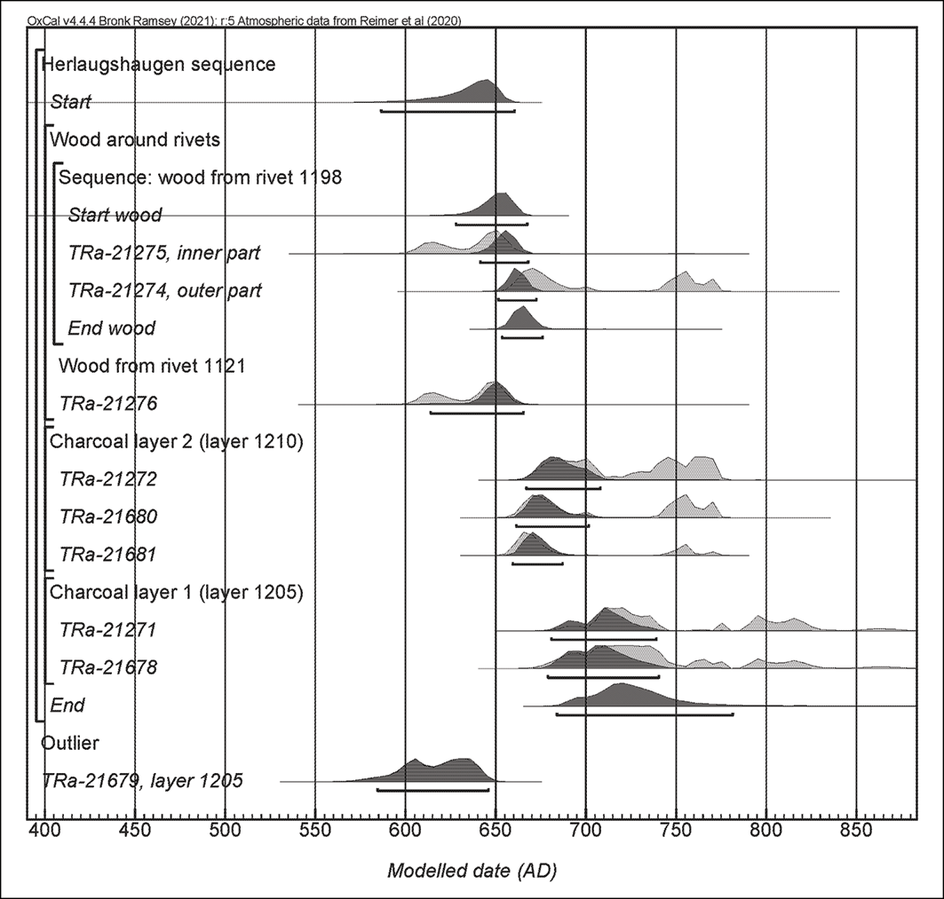
To create a Bayesian age model for the construction of the mound, we included the information that the charcoal layers are stratigraphically younger than the ship burial but did not include any assumptions about the duration of the time gap between the ship burial and the charcoal layers—it could have been zero as well as many years. The model (Figure 7) indicates that the ship was constructed after AD 670, with the mound then built either in the late seventh century or at the beginning of the eighth century.
Age model for the radiocarbon dates from Herlaugshaugen. Calculated with OxCal v.4.4.4 (Bronk Ramsey Reference Bronk Ramsey2009), using a sequence model (Bronk Ramsey Reference Bronk Ramsey1995) and the calibration curve IntCal20 (Reimer et al. Reference Reimer2020). Light grey probability distributions represent unmodelled ages, while dark grey represents the modelled ages (illustration by Bente Philippsen, NTNU University Museum, Norwegian University of Science and Technology).

Figure 7 Long description
The line graph displays radiocarbon dates from Herlaugshaugen, calculated using OxCal v.4.4.4. The x-axis represents modelled dates in A D, ranging from 400 to 850. The y-axis lists various samples, including wood around rivets, wood from rivet 1198, wood from rivet 1121, charcoal layer 2, and charcoal layer 1. Light grey probability distributions represent unmodelled ages, while dark grey represents modelled ages. The graph includes multiple data points for each sample, showing the range and probability of dates. All values are approximated.
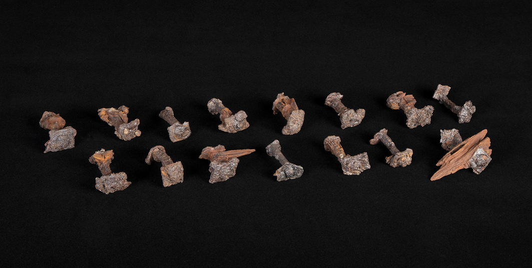
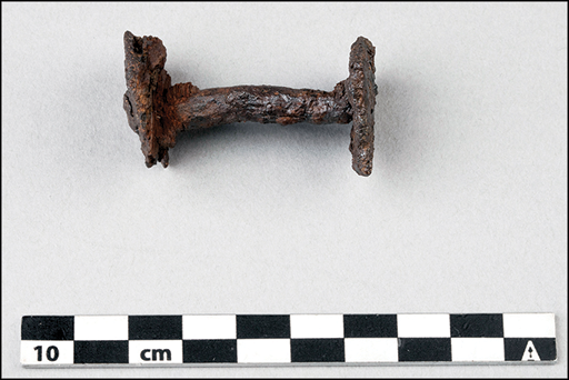
The 29 iron rivets are consistently large and well-preserved, some with wood remains adherent (Figures 8 & 9). The average shaft length is 50mm. The nail heads have diameters of up to 29mm, and the roves (washers hammered onto the shaft as it emerges from the wood to secure the nail in place) are mostly rectangular, measuring up to 30mm in diameter. Considering their size, these are most likely clinker nails from a ship. They are comparable to those found in excavations of large ships like the Gokstad, Oseberg and Tune ships (Shetelig Reference Shetelig and Brøgger1917a & Reference Sheteligb; Nicolaysen 2003 [Reference Nicolaysen1882]). All but two of the nails are clinker nails for clenching the planks along the hull. One nail is shorter than the others and is probably a scarfing nail for securing the scarf across two planks (an end-to-end join to create extra length). Another is probably a stem nail, used for securing the end of a plank against the stem of the ship. The stem nail has no rove as it is hammered through the plank directly into the stem or stern (Christensen Reference Christensen2022: 104–108).
Clinker nails from trench A (photograph by Freia Beer, NTNU University Museum, Norwegian University of Science and Technology).

Detail and size of clinker nail from the ship (photograph by Freia Beer, NTNU University Museum, Norwegian University of Science and Technology).

Figure 9 Long description
The image features a rusted clinker nail from a ship, exhibiting signs of age and wear. The nail is positioned horizontally on a white background. Below the nail, there is a measurement scale indicating the size, with a 10-centimeter segment clearly marked. The nail appears to be made of metal and has a rough, corroded surface, indicative of prolonged exposure to the elements.
Most clinker nails were found in trench A (Figure 6), which covers only a small area of the ship, providing limited information about its shape and size. As the length of clinker nails varies depending on their location within the ship, and those recovered in the 2023 excavation are consistent in size, it is likely that they derive from the ship’s mid-section, below the waterline. Planks would typically be thinner, requiring shorter nails, higher up on the body and further towards the stem (front) or stern (back) of the ship (Christensen Reference Christensen2022). The size of the nails also suggests a large ship, comparable to previous finds of ships measuring around or over 20m in length.
The conclusion is that the Herlaugshaugen mound is a ship burial dating to around 700 AD. The ship measured over 20m in length and may have been oriented from south-west to north-east. The two layers of charcoal in the upper part of the mound were added either simultaneously with the ship burial or possibly later. They may indicate subsequent cremation burials, as at Haugar in Tønsberg where burnt human bones were discovered in a charcoal layer within the large mound (Gansum Reference Gansum2013).
Discussion
The new discoveries at Herlaugshaugen raise questions concerning the sociopolitical context of ship burials. The mound stands out for its early date and for its location, far north of most well-known ship graves. Based on current evidence from the wider region, speculation on any direct links between Herlaugshaugen and the development of royal power would be largely conjectural, but some long-term societal processes, of which Herlaugshaugen and Leka were a part, may be inferred.
Herlaugshaugen is located by the harbour at Leka on the farm Skei. The name Skei is usually associated with recurring gathering places known for their markets and sport, including horse fights (Loftsgården Reference Loftsgården and Albris2023; Maixner Reference Maixner and Albris2023). The neighbouring farm is named Leknes, which may be derived from the island’s name but can also be interpreted as the Norse leikr, a place where groups of people gathered and various games were played (Rygh Reference Rygh1898). Sports and games can be seen as conflict-reducing and may have brought different groups together, acting as a means to sate rivalries and relieve tensions (Giulianotti Reference Giulianotti and Giulianotti2004; Semple et al. Reference Semple2021: 257). Until 1681 there was a church at Leknes; close to the church was a site named Tinghaugen (Thing mound). There is no mound at the site today, and we do not know how old the name is, but residents suggest it is an old name linked to the tradition of a ‘thing’ or assembly at Leka. If Leka was a gathering place for people from a larger area, the first that greeted visitors arriving across the strait from the mainland or from further along the coast would have been the monumental Herlaugshaugen by the harbour, demonstrating the political strength exerted by the region of Leka.
Leka and Herlaugshaugen can also be seen to connect the region to a bigger area. Ships represent journeys, and the old form of ‘Norway’, ‘Norvegr’, means ‘the way to the north’ or ‘the route between the straits’, as the old Norse word for strait was ‘nor’ (Østmo Reference Østmo, Skre and Hedlund Stylegar2023). The coast has been an essential route for transporting goods and people throughout prehistory and became increasingly important as ship technology developed. Traded and plundered goods such as stockfish, skins, furs, antlers, iron, marine oil and whetstones were transported south along the Norwegian coast and exported to other northern European coasts. Accounts of the travels of Ohthere, a Viking Age explorer and trader from Hålogaland (the northernmost part of Norway), in the ninth century reveal trade from the north and further south (Nilsen Reference Nilsen2017; Storli Reference Storli2018). The trade in whetstones from Mostadmark in the Trondheim fjord was extensive in the eighth century (Baug et al. Reference Baug2018, Reference Baug2024) and finds of reindeer antlers in Ribe, Denmark, show that trade with the north was well underway from the mid-eighth century (Ashby et al. Reference Ashby2015; Baug et al. Reference Baug2018; Philippsen et al. Reference Philippsen2022). Artefacts of continental design found in a seventh- to eighth-century burial ground on Ytre Kvarøy, a small island on the outer coast of Nordland, further demonstrate contact with wider European cultures (Heen-Pettersen Reference Heen-Pettersen2019).
Leka exhibits distinctive geological formations resulting from the uplifting of a section of the ocean floor during the tectonic collision that formed the Caledonian mountain chain. The distinctive yellow and red rocks create a unique landscape found nowhere else in Norway. These features could have drawn people to Leka just as the tectonic rift drew people to Thingvellir in Iceland (Semple et al. Reference Semple2021: 262). This synergy of geological forces, fertile agricultural lands, abundant fisheries and a secure harbour along the ‘Norvegr’ sailing route could be demonstrated to regional authorities through the construction of a monumental mound, marking the entrance to a location with regional centre functions. As such, Leka and Herlaugshaugen can be seen as a node in a regional network that connected people over a larger area.
Most excavated pre-tenth-century ships are interpreted as multi-functional vessels propelled with sail and oars, crewed by warriors and used for raiding and probably as cargo ships. Ling and colleagues (Reference Ling2018) propose a maritime mode of production in which raiding and trading were part of the same economy and a way for emerging elites to gain control over wealth flows. Leaders like the one buried in Herlaugshaugen probably built their power by being active and successful participants in this maritime mode of production.
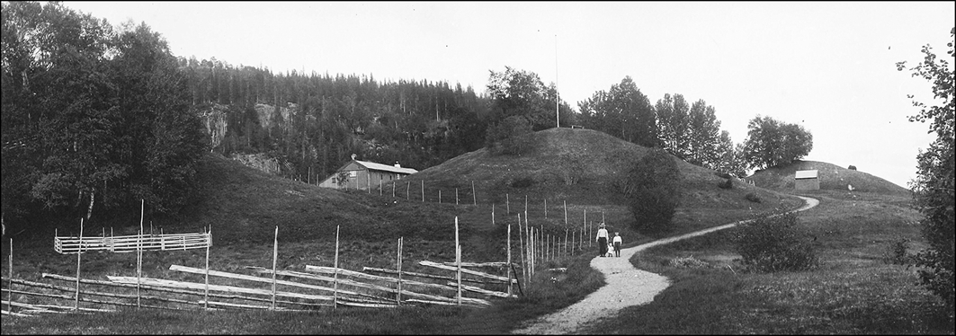
However, contact south along the coast and towards the continent was not the only network in which the people of Namdalen participated. Several researchers have discussed the possibility that artefacts and boat burials indicate contacts between Trøndelag and Uppland on the eastern coast of Sweden (Gjessing Reference Gjessing1934: 32, 54; Marstrander Reference Marstrander1956; Grønnesby Reference Grønnesby2019: 219). The importance of the valley communication route towards Sweden is evidenced by similarities in archaeological finds in the two regions. In 1884 the British traveller A.H. Cocks was the first to notice the similarities between the three large mounds (each approximately 50m in diameter) on the Trøndelag farm Bertnem (Figure 10) and the ‘royal mounds’ at Uppsala.
The monumental mounds at Bertnem (photograph taken in the 1920s by Theodor Petersen, NTNU University Museum, Norwegian University of Science and Technology).

Figure 10 Long description
The monumental mounds at Bertnem photographed in the 1920s by Theodor Petersen, NTNU University Museum, Norwegian University of Science and Technology. The image shows a landscape with two prominent mounds in the background, surrounded by a fence. A dirt path leads up to the mounds, with a few people walking along it. The area is covered in grass and trees, with a forested hill in the distance. The photograph captures a historical site with significant archaeological importance.
When exactly people from Scandinavia started crossing the North Sea by ocean-going vessels remains an active debate (e.g. Barrett, Reference Barrett2008, 2010; Heen-Pettersen Reference Heen-Pettersen2019; Lund & Sindbæk Reference Lund and Sindbæk2021). Insular materials are found in substantial quantities in Norwegian graves of the ninth and tenth centuries (Griffiths Reference Griffiths2025: 39–41), a period when the ship burial tradition was fully developed, indicating a well-established sailing route and connection between Britain and Scandinavia. There is no definitive evidence of direct contact between Norway and the British Isles between the Migration Period (AD 550–800) and the latter part of the eighth century (Heen-Pettersen Reference Heen-Pettersen2019). Even so, Herlaugshaugen may point toward a shared cultural milieu with distinct similarities in burial tradition and material culture (Gosden Reference Gosden2004: 41). Although the evidence for contact during the seventh and eighth centuries remains elusive, it is not negligible (Bonde & Stylegar Reference Bonde and Stylegar2016: 11–13; Heen-Pettersen Reference Heen-Pettersen2019). The discovery of a seagoing ship from the late seventh century at Herlaugshaugen adds substantial support to the argument for a continuous tradition of monumental ship burials extending from East Anglia to Scandinavia.
If the mound represented the deceased person and glorious achievements in the past, then Herlaugshaugen can be seen as a visual claim for a position in the expanding socioeconomic networks, including a place in the vertical strata. Carver (Reference Carver and Jackson2016: 141) believes that ship graves were built in different places at different times and were not an expression of an evolutionary trend or the product of a single cause, instead one must look for individual historical contexts. With the close contact between more northerly areas and the continent, the people of Scandinavia knew about Christianity. The large mounds covering ship burials can be seen as an alternative way of legitimising power. Instead of ruling as the king by the grace of God (Steinsland Reference Steinsland2005: 94), the leaders based their authority on the legitimising power of the monumental mounds. The monumental ship burials of East Anglia and Namdalen speak to the emergence of power with an ideology and rooted in maritime activity. Herlaugshaugen and the other monumental mounds in Namdalen should be seen as part of the processes of territorialisation and hierarchisation during the Late Iron Age (AD 550–1050) (Grønnesby Reference Grønnesby2019: 280; Paasche et al. Reference Paasche2024). These processes took root around the entire North Sea, albeit in different ways and at different speeds (Carver Reference Carver2005: 499; Paasche et al. Reference Paasche2024). Herlaugshaugen should be seen as a monumental expression of maritime mobility and competence that connected people and created new elites that, in time, formed kingdoms.
Conclusion
New excavation at Herlaugshaugen reveals that the phenomenon of monumental ship graves was not restricted to southern Scandinavia, the northern Norwegian coast was also integrated into networks established in the seventh and eighth centuries. Processes of territorialisation and hierarchisation in the Late Iron Age could not have occurred without the establishment of earlier inter-regional networks, of which Herlaugshaugen was a part. The monumental ship mound at Leka represents another piece of the puzzle for understanding the societal development of northern Europe in the seventh to tenth centuries AD.
Data availability statement
The excavation report is available on the museum website. The radiocarbon dates are in the OSM. https://www.ntnu.no/documents/10476/1364720800/NTNU+Vitenskapsmuseet+arkeologisk+rapport+2025_7+Herlaugshaugen+Leka.pdf/0ff3ea66-e672-0c27-0949-214a9ebe5f1f?t=1748256091273
Acknowledgements
Thanks to James H. Barrett for commenting on the manuscript; Francis Lucas Lukezic for the conservation work on the rivets; Wendy Khumalo, Izabela Rzadeczka-Juga and Helene Løvstrand Svarva for wood identification and sampling; John Øystein Haarsaker, Eirik Sollid, Mats Hansen Aspvik and Martin Seiler for radiocarbon sample preparation and measurement; and Anders Svendsen Fortun for participating in the excavation.
Funding statement
The excavation was funded with NOK 100 000 by the Directorate for Cultural Heritage. Parts of the fieldwork and conservation was funded by NTNU University Museum and the Trøndelag County Authority.
Online supplementary material (OSM)
To view supplementary material for this article, please visit https://doi.org/10.15184/aqy.2026.10330 and select the supplementary materials tab.
Author contributions: using CRediT categories
Geir Grønnesby: Conceptualization-Lead, Funding acquisition-Lead, Investigation-Lead, Project administration-Lead. Hanne Bryn: Data curation-Equal, Writing - review & editing-Supporting. Lars Forseth: Investigation, Writing - review & editing. Bente Philippsen: Data curation-Equal, Writing - review & editing-Equal. Knut Paasche: Writing - original draft-Supporting. Christian Løchsen Rødsrud: Writing - review & editing-Supporting. Arne Abel Stamnes: Writing - original draft-Supporting.


 Open access