

Introduction and background
Tunisia is a key region for understanding the nature and dispersal of early African humans (Homo sapiens) in the period 300,000 to 10,000 years ago (Drake et al. Reference Drake, Blench, Armitage, Bristow and White2011; Coulthard et al. Reference Coulthard, Ramirez, Barton, Rogerson and Brücher2013). A focus of special interest is a ribbon of former lake basins known as the Chotts which runs through southern Tunisia and Algeria on the northern edge of the Sahara, occupying a very large surface catchment area of some 814,000 km2. Today, the Chotts form an inhospitable ‘barrier’ of extensive saline mudflats but the presence of freshwater mollusc species on former lake shorelines suggests past conditions were much more favourable for humans and other animals (Causse et al. Reference Causse, Ghaleb, Chkir, Zouari, Ben Ouezdou and Mamou2003). At its fullest extent, the basin would have formed a ‘megalake’ fed by local springs and small rivers emanating from the Atlas Mountains and by major river systems that have their sources in the Tassili n-Ajjer and Hoggar Mountains of the central Sahara (Figure 1). It was in proximity to these peripheral streams and springs, whether just above or below the contemporary shoreline (groundwater baseline), that salinity would have been at its lowest and the surface water, in many places, potable. Such factors would of course have been particularly important in influencing the distribution of humans in the landscape and in determining the extent to which the Chotts occupied a strategic position for populations migrating north of the Sahara. However, despite the immense potential relatively little is known about the early prehistoric occupation of this region of North Africa.
Map of Akarit and other sites mentioned in the text in relation to the Chotts ‘megalake’. The thin white line shows the putative shoreline of the megalake at its maximum, the black line shows the boundary of its catchment and the thick white lines indicate rivers that flowed into the lake (N. Drake).

A new project to survey and investigate the Middle Stone Age (MSA) and Later Stone Age (LSA) occupation in southern Tunisia was initiated by the University of Oxford and the Institut National du Patrimoine de Tunisie in 2013 and a first season of field survey took place in 2014. The aims of the project were to map, identify and undertake small scale excavation and sampling of known and newly discovered MSA and LSA sites in the area of the former Chotts megalake and related drainage basins (Figure 1). The overall objective was to collect chronological, environmental and cultural evidence that would allow clearer understanding of the nature and periodicity of human occupation in southern Tunisia close to the present northern edge of the Sahara. Oued el Akarit was amongst several locations selected for survey, as it presented a significant clustering of springs, potentially forming part of a natural corridor for wildlife and human populations in between the Sahara and the Mediterranean Sea. During more arid phases, the springs would have offered freshwater, riparian vegetation and aquatic resources, and may have formed ‘oases’ of human and animal activities in their own right.
The site and its context
Oued el Akarit has been known for its high density of archaeological sites since the 1930s (Gobert Reference Gobert1962; Gobert and Howe Reference Gobert, Howe and Balout1955; Roset and Harbi-Riahi Reference Roset and Harbi-Riahi2007). The main point of interest is an area of exposed Upper Pleistocene age deposits in the lower part of the oued (Figure 2), close to where the GP1 highway and railway line cross the wadi near the village of El Akarit. It lies about 25 km north of the provincial capital of Gabès in southern Tunisia.
Location of Akarit S8 and other excavations including S1 and S2.

Structural geology and sedimentological setting
Presented here is a summary of observations relating to the local geology. A more detailed discussion of the Quaternary structural geology of Oued el Akarit will appear in a future publication. The present oued flows southeastwards and then eastwards before reaching the sea at approximately the mid-point of the Gulf of Gabès embayment. The modern catchment is relatively small, with various authors giving estimates in the range ca. 75–110 km2; the west–east extent of the modern catchment is only 17 km. During occasional torrential rainfall events, there is potential for considerable geomorphological remodelling but in this arid to semi-arid area, there would probably have been very little, if any, surface water availability during much of the Upper Pleistocene and Holocene – indeed, the upper and middle reaches of the catchment are normally dry today. However, the oued runs through the El Meïda GrabenFootnote 1 between two zones of fault-bound highlands. Crossing the hard-rock basement of this graben somewhat obliquely, there is at least one major fault zone that is able to tap into artesian waters, with very slow (>20,000 years) turnover times, originating from the mountains to the north of the Chotts. Published hydrographic studies in the area have suggested that the piezometric headFootnote 2 is several metres above the general land-surface (despite the water table being radically lowered by agricultural and industrial pumping), the potential for springs being limited only by the extremely low transmissivity within the deep fault system. There is therefore reason to believe that, whilst springs would have been located in the topographic low-points available at any given time, the actual altitude of these low-points would not have mattered greatly during the timescale of interest here, suggesting that water at the surface would have been available in this vicinity more or less continuously, irrespective of the point (altitude) in any given sedimentary cycle (see below).
In the lower reaches of the modern oued (after the confluence with a main northern tributary and in the zone most affected by the deep artesian seepage, the last 5 km before the modern coast), the general surface lies at an altitude of some 25 m above mean sea level, dropping towards the east; it is only from this point that there has been strong incision, creating a ‘gorge’, now as much as 40 m wide at the base (potential floodplain) and rarely more than 80 m wide at the top, and up to 15 m deep in places. The present ‘gorge’ is wholly Holocene in age. The gorge downcutting has exposed stacks of much older sediments (usually dominated by material in the coarse silt to fine sand grades), each accretive cycle (representing sequences of ca. 10–20,000 years in stacks of exposed thicknesses in the range ca. 5 to 15+ m) separated by incision events, the unconformities bounding previous ‘valleys/gorges’, not necessarily following exactly the modern thalweg.Footnote 3 There is therefore great archaeological and palaeontological potential in these normally very well stratified sequences. However, there is also considerable structural complexity, because these weakly consolidated/cemented sediments have responded again and again to localised faulting, slippage, rotation, plastic deformation and mass movement, whenever an incision event has produced significantly steepened ‘gorge-sides’. This instability is exacerbated by the continual presence of basal artesian input. This complexity has tended to mislead many researchers in the past, who have envisaged incorrect depositional environments or who have had to call upon improbable ‘external’ factors (massive neotectonism, tsunamis, etc.) to try to explain their observations.
Sondage 8 excavation
The site, originally described by Page (Reference Page1972) as ‘Site A-3’ was re-located during the present survey and excavated as ‘Sondage 8’, hereafter ‘S8’ (Figure 2). It occupies a position close to the summit of the modern gorge-side and a significant way back from (south of) the present thalweg. Whilst there is an erosive unconformity bounding the top of the sequence of interest, the block of sediment containing S8 is not internally divided by deep faulting or disturbed by major deformation, although it is slightly tilted (toppling down outwards/northwards by 2–5°) probably indicating that it is backed by faults. Therefore, this sequence still stands largely as it was deposited, hardly affected by the close approach of subsequent steep incision events. We cannot, as yet, describe the general valley geomorphology at the time but both internal evidence and the overall Akarit model, very briefly summarised above, suggest that surface water would have been available in the vicinity of the site.
In 2015 an area of about 9 m2 was excavated by hand. The main archaeological occurrence was identified by a band of dark brown sediment about 4 cm thick, with a thin lighter brown sediment below this, together designated Excavation Unit (EU) 8005/6 (Figures 3 and 5). All excavated sediments were dry sieved at 5 mm and in situ finds >15 mm three-dimensionally recorded using a total station. During this phase samples for dating and environmental analyses were also collected. The latter included the removal of a small block of consolidated sediment for soil micromorphology from the middle of the occupation area and a series of samples for chemistry and magnetic susceptibility. Further investigations took place in 2019 when the lithostratigraphic sequence was fully described and sediments across the archaeological interval were sampled for cryptotephra analysis and some limited further excavation occurred.
Outer face of Sondage 8 before full excavation. Main archaeological interval (EU 8005/6) which thickens westwards (into the section). OSL gamma-spectrometer holes indicate sample locations (AKR14-06 to 08) and equivalent stratigraphic position of 14C dated Ostrich Egg Shell (OxA-33204) in EU 8005/6. Scale one metre (10 cm intervals). (photo: S.N. Collcutt).

Description of the lithostratigraphic sequence and interpretation
A description of the S8 sequence (Table 1) shows from the top downwards depths (in metres) above the main Site Datum, and is classified according to very dry (weathered) Munsell colours. Because of variability in the quality of available exposure, the sequence was recorded in two sections, one a few metres to the SE of the excavated area and the other towards the NE (in square L6), although the stratigraphic continuity of the partial overlap in the ca. 3 m laterally between the two is demonstrable. Previous main sampling points are noted.
Description of lithostratigraphic sequence.

From the field exposures described in Table 1, certain interpretations can be suggested concerning the depositional environments in this sequence (with additional micromorphological observations below). Leaving the superficial phenomena aside (which are probably dominated by Holocene diagenetic and pedogenic overprinting), the whole sequence exposed at S8 represents a rather steady accretive sediment stack, with no major erosive phases and no obvious unconformities or non-sequences. Where not disturbed by bioturbation, fine bedding structure is nearly always present, usually horizontal laminar but occasionally wavy- and even cross-bedded (small ripple-form, very rarely smallest dune-form). The impression is one of a local zone dominated by oscillating very shallow water and wind-flat conditions, probably in at least a semi-arid environment. The ‘greenish’, often very slightly clayey intervals, usually with reddish iron-oxide traces, suggest minor marshy (reducing) conditions; in the logged sequence, such ‘greenish’ beds occur mostly below the main archaeological interval (EU 8005/6) but there is a lens of such material (becoming quite dark in places) well above EU 8005, some 15 m further west, showing that this facies is part of the recurrent set of motifs in this general stratigraphic interval. Indeed, it is worth noting that the fine bedding is often continuous, usually at scales of tens of metres and, in some cases as much as a hundred metres (allowing for subsequent faulting). Factoring in the more continuous fine carbonate intervals and crusts (Table 1), much of this accretion would appear to have occurred in or immediately around very shallow perennial pools/lakes. It is noteworthy that, in this sequence, there are no signs of ravining, of other sharply erosive events or of mass movement. From a sedimentological point of view, given accretion in a sediment-rich environment, there is no reason to suggest a time scale for the logged sequence (barring the superficial phenomena) of more than a few thousand years (see radiometric dating evidence below).
Because the bedding features in this sequence survive so well, it is unlikely that there was very much vegetation (though perhaps a little more, near marshy accumulations). Thus, the surfaces in the immediate S8 vicinity would usually have been rather low in nutrients. It is therefore probably no coincidence that the main archaeological interval (EU 8005/6) and its adjacent beds show concentrated small-scale bioturbation (dense insect burrows and perhaps some plant rooting); the human presence, on what would have been a temporarily dry surface (perhaps even slightly raised above the hinterland), seems to have introduced significant organic matter, attracting subsequent biological activity (Figures 4 and 5). As these organics decayed or were recycled, original carbonates and gypsum were remobilised somewhat, encouraging the deposition of manganese from groundwater and the formation of fine local carbonate crusts and gypsum crystals at interfaces. This general association (especially with micro-krotovinas) is commonly found at other, otherwise undisturbed archaeological levels at Akarit.
Towards base of main archaeological interval (Excavation Units 8005/6, square L5), excavation surface showing penecontemporaneous bioturbate structures (buff colour) in plan (scale 10 cm)(photo: A.J. Roberts).

Main archaeological interval (Excavation Units 8005/6, square L6), vertical section 2019 (scale 10 cm) (photo: S.N. Collcutt).

Soil micromorphology, chemistry and magnetic susceptibility
Two thin sections and seven small bulk sediment samples were analysed for soil micromorphology, chemistry and magnetic susceptibility, the latter to determine the extent of burning in the archaeological horizon EU 8005/6. The thin sections (1A and 1B) were obtained from one monolith box sample taken from within square P6. The bulk sediment samples were taken from small sections both above and within the occupation horizon.
Soil micromorphology
The thin sections (Table 2) were analysed using a petrological microscope under plane polarised light (PPL), crossed polarised light (XPL), oblique incident light (OIL) and using fluorescence microscopy (blue light – BL), at magnifications ranging from x1 to x200/400. Thin sections were described, ascribed soil microfabric types (SMTs) and microfacies types (MFTs) (Tables 2 and 3), and counted according to established methods (Karkanas and Goldberg Reference Karkanas and Goldberg2018; Macphail and Goldberg Reference Macphail and Goldberg2018; Nicosia and Stoops Reference Nicosia and Stoops2017).
Soil micromorphology samples and counts.

* - very few 0-5%, f - few 5-15%, ff - frequent 15-30%, fff - common 30-50%, ffff - dominant 50-70%, fffff - very dominant >70%; a - rare <2% (a*1%; a-1, single occurrence), aa - occasional 2-5%, aaa - many 5-10%, aaaa - abundant 10-20%, aaaaa - very abundant >20%
Soil micromorphology descriptions and preliminary interpretations.

Micromorphology results: (1A and 1B)
Below EU 8005/6 the sediments are partially bio-worked, cemented gypsum-dominated fine sands (Figure 6). EU 8005/6 itself consists of part gypsum cemented and burrowed fine sands. In contrast to the underlying deposits, it is also characterised by concentrations of variously burnt bone, and rare burnt mineral material (Figures. 6–12). The presence of only trace amounts of calcitic ash (Figure 13) and charcoal may be due to taphonomic effects (leaching and winnowing) (cf. Goldberg and Macphail Reference Goldberg, Macphail, Barton, Stringer and Finlayson2012; Macphail et al. Reference Macphail, Goldberg, Barton, Barton, Stringer and Finlayson2012; Mallol et al. Reference Mallol, Mentzer, Miller, Nicosia and Stoops2017). The deposit was also affected by tiny insect and worm burrows associated with likely secondary phosphate from overlying possibly guano-rich layers (Figures 14 and 15).
Scan of OAK-1A; weakly humic combustion zone (8005) containing variously burnt bone fragments (VBB), over gypsum-cemented fine sands (Below 8005). Note broad burrows with darker (phosphate?) infills (Bu). Frame width is ~50 mm. All scans and photomicrographs by R. Macphail.

Photomicrograph of OAK-1A; combustion zone with rubefied burnt bone. Plane polarised light PPL, frame width is ~4.62 mm.

Photomicrograph of OAK-1A; combustion zone with (black) calcined burnt bone. PPL, frame width is ~4.62 mm.

As Figure 8, calcined bone is white, under oblique incident light (OIL).

Photomicrograph of OAK-1A; combustion zone with rubefied burnt bone (Bo) and gypsum cementation (Gy). PPL, frame width is ~4.62 mm.

As Figure 10, under crossed polarised light XPL; note coarse silt-very fine quartz sand, and first order birefringent gypsum cement.

As Figure 10, under OIL; grey burnt bone (Bo) and whitish grey gypsum (Gy).

Photomicrograph of OAK-1A; combustion zone with trace amounts of probable strongly birefringent (‘bright’) calcitic ash crystals scattered throughout. XPL, frame width is ~0.47 mm.

Photomicrograph of CZ in OAK-1B containing fine burnt bone, with broad dark channel fill – gypsum fine sand with isotropic matrix – presumed hydroxlapatite (arrows). PPL, frame width is ~4.62 mm.

As Fig 14, under XPL; fine feldpsar, quartz and gypsum sands, with isotropic phosphate matrix.
Bulk soil chemistry and magnetic susceptibility
A five-parameter analysis routine, developed and adapted for soil prospection and bulk analysis of occupation soils and features, was applied to all the seven bulk samples analysed. These analyses provide information on phosphate, iron and other magnetic components and total organic matter in soils and sediments, and its relationship to phosphate (Viklund et al. Reference Viklund, Linderholm, Macphail and Gerpe2013). Analysed parameters comprise organic matter (loss on ignition [LOI], Carter Reference Carter1993), two fractions of phosphate (inorganic [Cit-P], and the sum of organic and inorganic [Cit-POI]) (Linderholm Reference Linderholm2007), magnetic susceptibility ([MSlf] and after oven heating at 550 degrees C to approximate total potential magnetic susceptibility of the natural background [MS550], in this case a good proxy for iron content, Clark Reference Clark1996; Linderholm Reference Linderholm2007).
Results of chemistry and magnetic susceptibility
The identification of a burnt, bone-rich, occupation horizon is consistent with enhanced MS, marked phosphate concentrations and a noticeably higher LOI, compared to sediments both above and below EU 8005/6 (Table 4). The occurrence of suggested hydroxylapatite in burrowed-down soil indicates probable mixing with an overlying hypothetical guano-rich (bird presence) micro-layer (see Discussion section). Above EU 8005 (in EU 8002 and EU 8003), heightened proportions of organic phosphate compared to inorganic phosphate (Pquota; max 2.4) may record inputs of organic phosphate from guano (Table 4).
Five Parameter Analyses (M – magnetic susceptibility, MS550, fractionated P, LOI).

NB: CZ = combustion zone; lf = low frequency; hf = high frequency
Dating studies (optical luminescence, radiocarbon and tephrochronology)
Optically stimulated luminescence (OSL) dating provides an estimate of the time elapsed since luminescent minerals, such as quartz or feldspar, were last exposed to sunlight (Huntley et al. Reference Huntley, Godfrey-Smith and Thewalt1985; Aitken Reference Aitken1998). It has become a well-established dating technique in Quaternary science and the methodology is described in various publications (e.g. Duller Reference Duller2004; Lian and Roberts 2006). Three OSL samples were taken across the archaeological deposits (Figure 3) and they were prepared and measured according to methods described in Mirazón Lahr et al. (Reference Mirazón Lahr, Rivera, Power, Mounier, Copsey, Crivellaro, Edung, Maillo Fernandez, Kiarie, Lawrence, Leakey, Mbua, Miller, Muigai, Mukhongo, Van Baelen, Wood, Schwenninger, Grün, Achyuthan, Wilshaw and Foley2016). Sample AKR14-08 came from 50 cm above the main find horizon EU 8005/6, AKR14-07 from 10 cm above and AKR14-06 from 30 cm beneath the main find horizon. The results show remarkable internal consistency and none of the dates are distinguishable at one sigma (Table 5).
OSL data for Oued el Akarit (Sondage 8) including radionuclide concentrations determined by ICP-MS, dose rates using the conversion factors of Guerin et al. (Reference Guerin, Mercier and Adamiec2011), palaeodoses and age estimates.

*Determined on site with a portable gamma-ray spectrometer calibrated against the Oxford blocks. Source: Rhodes and Schwenninger (Reference Rhodes and Schwenninger2007).
The suitability of ostrich eggshell as a material for radiocarbon dating was explored several decades ago (Freundlich et al. Reference Freundlich, Kuper, Breunig and Bertram1989), and the method is now routinely applied to such material spanning the last 50,000 years from different parts of the world including Africa (e.g. Kandel and Conard Reference Kandel and Conard2005; Orton Reference Orton2008; Miller et al. Reference Miller and Willoughby2014). Three AMS radiocarbon assays were attempted on separate ostrich eggshell fragments (Table 6). They were selected, respectively, from the base of the archaeological horizon (unit EU 8006), from within the archaeological horizon (EU 8005/6) and from close to its top. Only the one from EU 8006 succeeded in producing a result. A fourth AMS sample was taken from an ostrich eggshell fragment in the immediately adjacent ravine (lateral to the main wadi) where another layer, S-8(A), very rich in fauna and MSA lithic artefacts had been exposed in a position near the base of the current incision. Significantly, this deeper cultural layer was separated from EU 8005/6 by an undisturbed stack of strata at least 4 metres thick. The obtained result (OxA-33205) from this eggshell is very close to the working limit of radiocarbon and should be considered a minimum age only. Despite the slight variance between the single AMS calibrated date and the OSL age estimates, all of the dates fall within the equivalent of MIS 3 (Marine Isotope Stage 3) of the global oceanographic record (Castañeda et al. Reference Castañeda, Mulltza, Scefuss, Lopes dos Santos, Sinninghe Damsté and Schouten2009).
AMS 14C data for Oued el Akarit (Sondage 8 and 8-A).

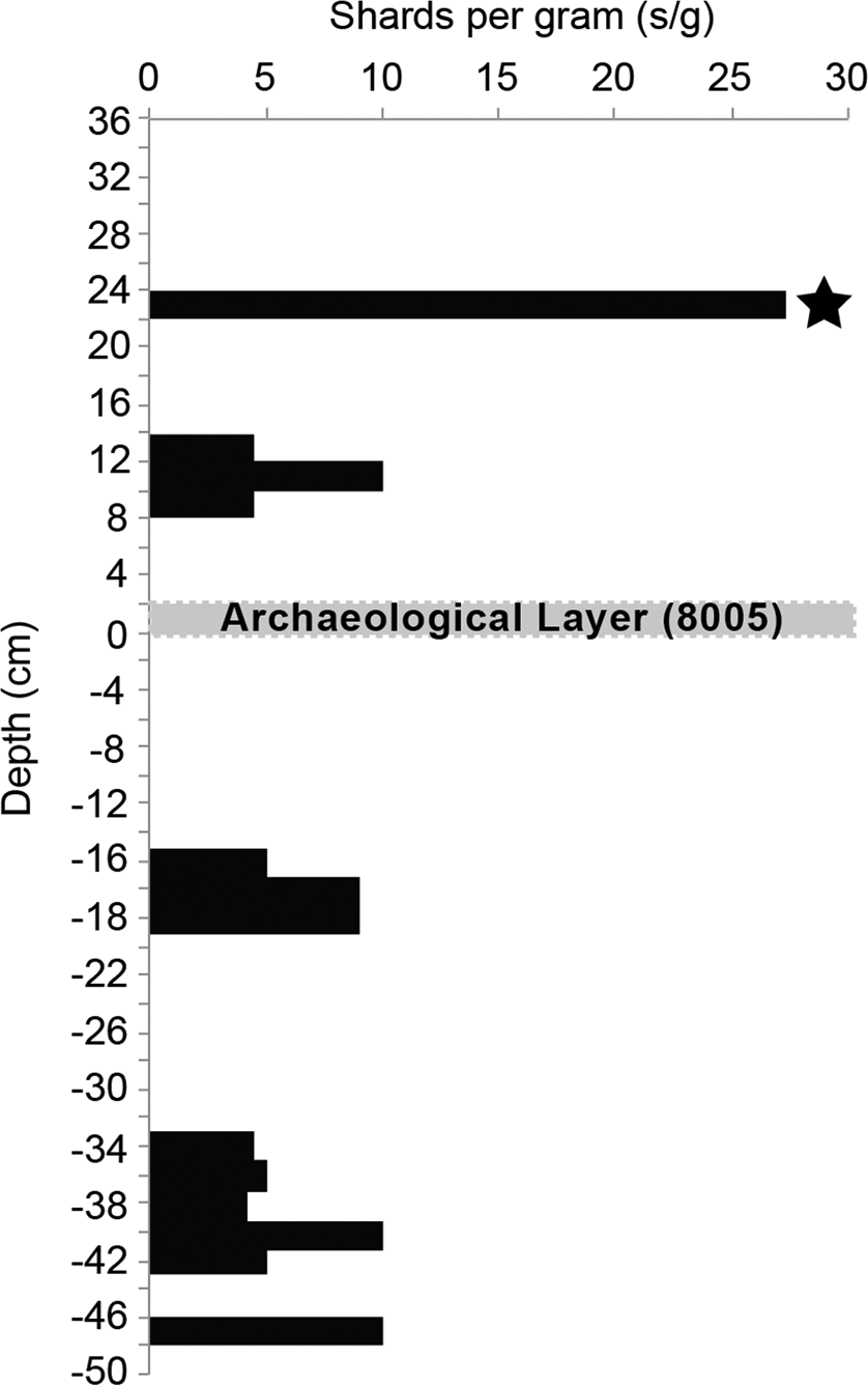
The sediments were examined for the presence of microscopic volcanic ash (cryptotephra) layers, which could provide additional chronological constraints for the site. Such cryptotephra layers have been identified in other key archaeological sites across North Africa (e.g. Barton et al. Reference Barton, Lane, Albert, White, Collcutt, Bouzouggar, Ditchfield, Farr, Oh, Ottolini, Smith, Van Peer and Kindermann2015). Potential volcanic sources include the productive Italian volcanoes located ~1000 km NE from Akarit, and the volcanic islands of the Canary Islands and Azores located 2500 W km, and 3500 km NW from the site, respectively. Sediments were sampled across the archaeological interval, as well as from above and below EU 8005/6 (Figure 16). All samples were wet sieved through a 60 μm and 25 μm mesh and processed using the heavy liquid floatation method outlined by Turney (Reference Turney1998). This procedure allows the volcanic glass shards, with a density between 2 and 2.9 g/cm3, to be effectively separated from the sediment. Samples were prepared alongside blanks, which demonstrated that there was no laboratory contamination. The number of glass shards per gram of dried sediment (s/g) from the samples that were taken vertically through the archaeological interval are shown in Figure 16. A significant horizon was identified 22–24 cm above the archaeological layer (EU 8005/6), which contains ~27 s/g. Shards here were clear and fluted with stretched vesicles. This horizon was targeted for geochemical analysis so that a potential source of this eruption event could be identified. Sediments that contained lower concentrations of glass shards (< 10 s/g) could not be geochemically characterised due to the low number of the shards and their morphology.
Glass shard concentrations (shards per gram of dry sediment) vertically through the sequence that contains the archaeological finds. A horizon with a concentration of glass shards (~ 27 s/g; marked by a black star) was identified in the sample taken 22–24 cm above the archaeological finds sub-units (EU 8005/6). Shards from this layer were chemically analysed but the volcanic source is not yet known.
Description of lithic assemblage
The artefacts described here all come from S8 EU 8005/6. They consist of a total of 516 pieces of debitage and cores and 25 retouched tools. They are classified according to the methods outlined in Geneste (Reference Geneste1985).
Raw material
The most common flint types recorded in the assemblage are identified as Cretaceous Senonian (grey and light brown) and Eocene (white-ish) flint. The sources of this flint can be considered ‘local’ according to the criteria devised by Geneste (Reference Geneste and Rigaud1988): local being within a radius of 5 km, regional from 5 to 20 km and exotic found up to 80 km away. In this instance, good quality raw materials are available in the Segui Formation (Cretaceous origin with Late Miocene alteration) that outcrops in relative abundance in drainage systems within 5 km of Oued el Akarit.
Debitage
The cores comprise 16 Levallois examples (including two Levallois core fragments), plus two cores on a flake and an unidentified core form (Table 7). With respect to the method of knapping, the Levallois cores are characterised by lineal preferential reduction. This describes the method whereby a single flake is detached for each prepared surface using the Levallois method (Inizan et al. Reference Inizan, Roche and Tixier1992; Boëda Reference Boëda1994). Both the cores and flakes in the assemblage indicate the frequent use of direct percussion with a hard hammer. The flakes consist of a mixture of cortical and non-cortical examples. If the smaller flakes (<20 mm in length) are excluded, it shows that roughly half (96/197) have either complete coverage or some degree of cortex on their dorsal surfaces, and is an indication that whole cobbles were imported and knapped on site.
Lithic debitage from S8 (based on the classificatory system of Geneste Reference Geneste1985).

Amongst the debitage is a high representation of small flakes and broken fragments which, together with the presence of pieces of shatter, including tiny fragments of less than 2 mm, suggests that the flint scatter had not been greatly disturbed. The flakes are all in sharp condition and refitting evidence (see below) indicates that they must have been incorporated quite quickly into the soft sediments leaving no obvious sign of long-term surface exposure (trampling, wind winnowing, wash) that might have led to more pronounced disruption of the flint scatter. During excavation we also noted an absence of any preferential orientation of the flint that might have implied sorting by wind action or by hydraulic processes. Many of the artefacts are burnt (Figure 17) and these are scattered across the excavated squares.
Distribution of artefacts (burnt vs unburnt) in S8.

Study of the lithic industry also identified 25 retouched tools, the great majority of which are side-scrapers (18 or 72%). The tools are on various supports: 24% on Levallois flakes, 36% on simple flakes/blades and resharpening flakes, and 8% on core-edge removal flakes (éclats débordants). In total a quarter of all the tools were made on Levallois flakes, which probably accounts for the relatively low proportion of Levallois flakes to cores in the whole assemblage. Only five of the tools are burnt.
The majority of tools are scrapers (Figure 18), of which 7 are single straight side scrapers (28% of tools), 5 are single concave side scrapers (20% of tools), 3 double side scrapers, 2 offset (déjeté) scrapers and 1 straight transverse scraper. The rest of the tools consist of a notch, a denticulate, a backed knife, a Mousterian point and a composite tool.
Side scrapers from S8. 139: single side scraper (broken); 680: double side scraper; 505: single side scraper (broken); 9: ventrally (inverse) retouched side scraper. (Photo: L. Belhouchet).

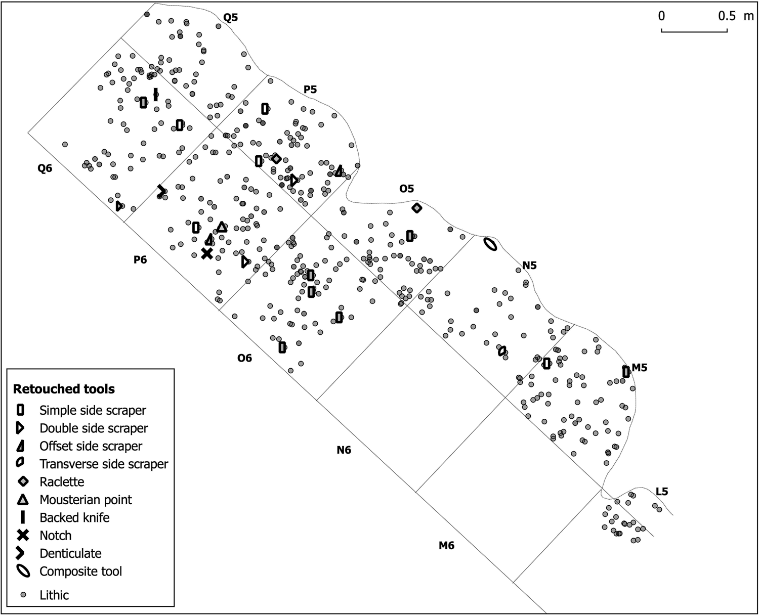
Regarding the distribution of these retouched tools, they are mainly concentrated in squares P5 and P6 (Table 8). However, the distribution map of tools according to type (Figure 22) suggests they might have been part of two clusters: one focusing in squares Q6, P5 and P6, consisting of simple and double scrapers, denticulate, notch, naturally backed knife and a Mousterian point; the other occurring in squares O5, O6, N5 and M5 with simple scrapers, a transverse scraper and a composite tool (Figure 19). Taken at face value this could indicate different production or activity zones or possibly a re-use of the site but one in which intensive use of scrapers was employed perhaps for hide preparation.
Retouched tool typology.

Distribution of retouched tools in S8 (H. Mekki).
Cut marked bones from S8 (Photos: N. Aouadi): a) Polished end of a bone splinter (OAK/S8/349); b) cut mark that runs obliquely to the long axis of the splinter (OAK/S8/571); c) bone splinter with multiple parallel grooves (OAK/S8/ 8059).

Refitting evidence
By refitting flakes to cores it is possible to reconstruct the chaîne opératoire in this lithic technology, including the different stages leading to the elaboration of flake surfaces to produce Levallois flakes. In EU 8005/6 one extensive core reduction sequence can be reconstructed. It was made of good quality Senonian flint and consists of a sequence of 26 flakes that could be refitted to a Levallois core and a related fragment. Two thirds of the refitting flakes were either cortical or partially cortical and confirmed that the whole cobble had been carried to the site. In terms of morphology, the refitted cortical flakes were on average thinner than the non-cortical flakes (see Table 9). Within the sequence were also two discarded Levallois flakes (broken during manufacture), both thin and regular and one of them being almost square in shape.
Average dimensions of flakes from the refitted Levallois core.

Flake platforms (butts) of the refitting flakes are generally faceted (15 out of 27) or dihedral faceted (with two intersecting flake scars = 2) (Table 10). Prominent bulbs on their ventral surfaces, frequently accompanied by bulbar scars (esquille bulbaire), indicate that they were made with a hard percussor. In the other largest category are flakes with plain and lipped butts (5) and likely also made using hard hammer percussion.
Butt types of flakes in the refitting core.

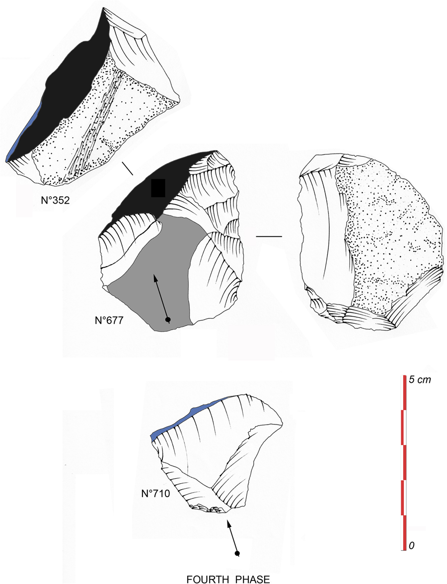
The reduction sequence reveals three Levallois flakes made using the lineal Levallois (preferential) method, with centripetal preparation and hard hammer percussion. The sequence can be split into four phases:
Phase 1 (Figure 23): the objective was to prepare a sub-circular Levallois tortoise core and to detach from its upper surface a preferential Levallois flake. However, this phase failed to detach the desired flake. The result is a broken piece (Figure 23, nos 402 and 671) due to a simple knapping error, namely a mis-hit (bounce) as the flake was struck.
Cut marked bones from S8: a) Cut marks that run obliquely to the long axis of a bone splinter (OAK/S8/8113); b) grooves running wavy and perpendicular to the long axis of a bone splinter (OAK/S8/8066); c) burnt bone splinter (OAK/S8/311).

Phases 2 and 3 (Figures 24 and 25): The core was rejuvenated and the flaking surface and striking platform prepared for a second preferential Levallois flake removal. The resulting Levallois flake could not be found in the excavated assemblage but from the negative scar left behind it would have been virtually the same shape and size as the first and third Levallois flakes from this cobble.
Distribution of lithic artefacts, bones and ostrich eggshell in S8 (H. Mekki).

Refitting from Phase 1 (Photo: H. Mekki).

Refitting from Phase 2 (Photo: L. Belhouchet).

Phase 4 (Figure 26): All the flakes of the core-preparation stage are present. They indicate that during this phase the flaking surface exhibited distal and lateral convexities, which facilitated control over the size and shape of the Levallois flake. During the removal of this third Levallois flake, the core and the flake broke in two. Figure 27 shows the whole refitted cobble.
Refitting from Phase 3 (L. Belhouchet).
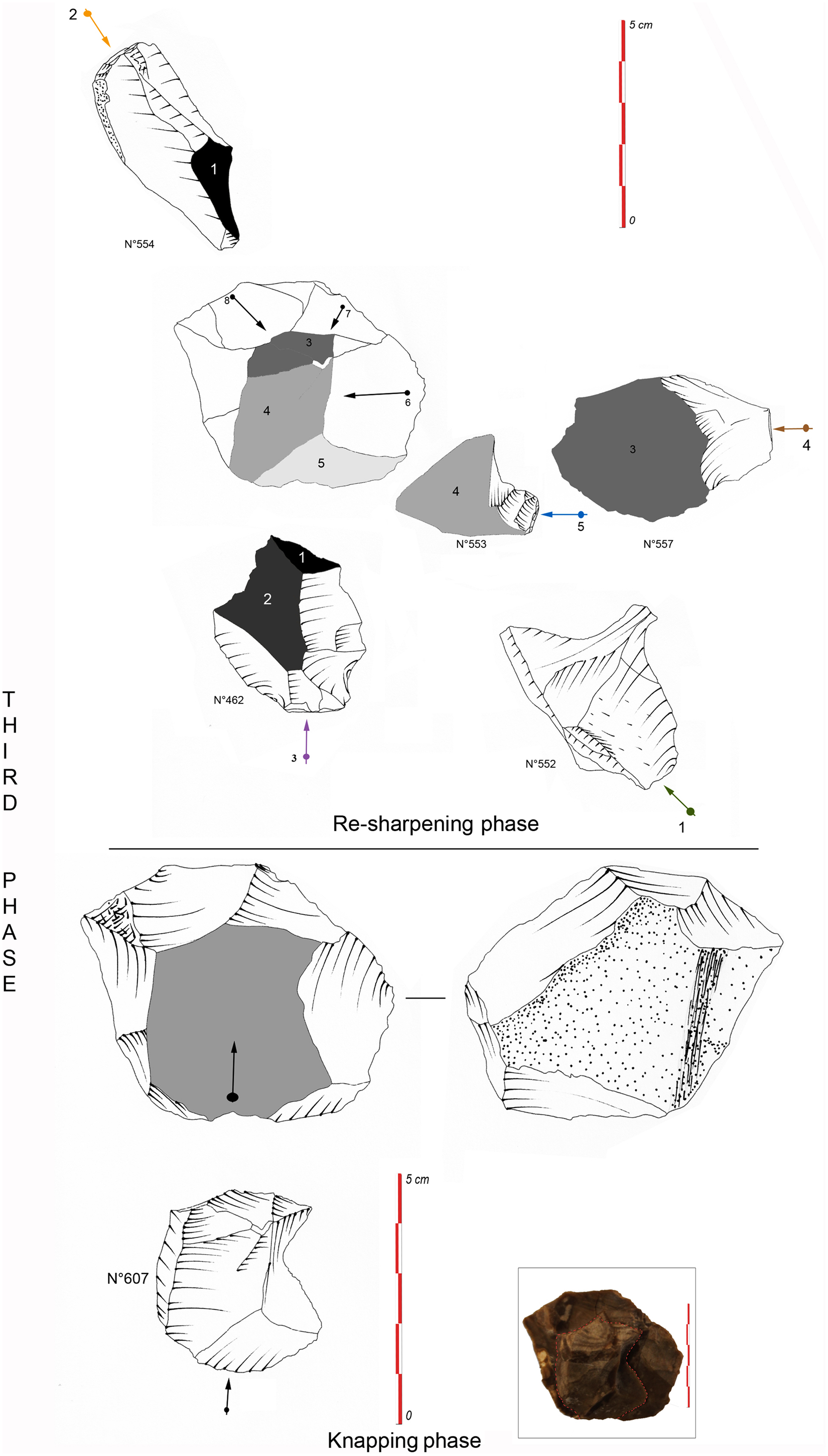
In sum, refitting and the analysis of removal scars on the flaking surfaces of the core and the flakes clearly shows that objectives were consistent with the goal of obtaining sub-quadrangular Levallois flakes. Three Levallois flakes were produced from a single cobble, with the refitting showing accidental breakages followed by rejuvenation. Two of these flakes could be refitted to the core while the third was never found and was presumed to have been removed for use somewhere off-site.
Faunal evidence
Vertebrate remains were identified using osteological collections housed at the Department of Prehistory in the Bardo Museum, Tunis. Each specimen was examined for anthropic and natural taphonomic marks using a binocular microscope. Cut marks were defined as straight, incised grooves displaying a V-shaped cross-section with internal parallel microstriations (Andrews and Cook Reference Andrews and Cook1985; Noe-Nygaard Reference Noe-Nygaard1989; Fisher Reference Fisher1995). Hammerstone percussion marks were identified as being pits and grooves with associated microstriations and lacking internal crushing (Johnson Reference Johnson and Schiffer1985; Blumenschine and Selvaggio Reference Blumenschine and Selvaggio1988; Roberts et al. Reference Roberts, Stewart, Alagaili, Breeze, Candy, Drake, Groucutt, Scerri, Throp, Louys, Zalmout, Al-Mufarreh, Zech, Alsharekh, Al Omari, Boivin and Petraglia2018). Burnt or heated bones were identified by the colour of external surfaces (cf. Brain Reference Brain1981; Lyman Reference Lyman1994; Stiner et al. Reference Stiner, Kuhn, Weiner and Bar-Yosef1995). Subaerial weathering was evaluated using the different stages defined by Behrensmeyer (Reference Behrensmeyer1978). Analysis of bone surfaces for possible weathering and erosion by water action was undertaken using a handheld lens and employing the methods of Lyman (Reference Lyman1994) and Isaac (Reference Isaac1983).
A total of 219 numbered remains of fauna (NR) was recovered in the excavations. They consisted almost entirely of fragmented mammal bones (196) and teeth (7) plus 16 ostrich eggshell fragments. Of these, five teeth can be broadly identified as bovids and classed according to size (Table 11). Only one of the bones can be identified taxonomically as a phalanx belonging to a 4–5 body-size mammal, while the five bovid teeth are from those ranging in body sizes from large (size 3, from Bovini group) to small (size 1, cf. Antilopini group). It is likely that the bigger bone fragments also belonged to a large bovid but this cannot be confidently asserted as they could also be from other large-boned ungulates such as equids or rhinoceros and for the present are classified under ‘other mammals’ (Table 11). The classificatory system of faunal remains is specific to the present study.
Distribution of mammal remains according to body size classes. (NR: Number of Remains).

As mentioned above most of the bones were broken and imply intensive fragmentation. Absence of tooth marks or related scavenging damage can be used to rule out the interference of carnivores and only one bone shows traces of dissolution without rounding which could have been due to water percolation. From the condition of the rest of the assemblage it is clear that the bones were not submerged in water for very long, if at all, or dispersed by hydraulic action. Equally, it is noticeable that the surfaces of the large mammal bones exhibit a slight degree of weathering (stages 1–2 in the scheme of Behrensmeyer Reference Behrensmeyer1978) (Table 12).
Weathering stages with only stages 1–2 (slightly weathered) and 3 (weathered) represented in the S8 assemblage (based on Behrensmeyer's 1978 scale of 0–5).

Signs of deliberate human modification are visible from percussion notches on long bones and spiral fracture patterns that imply working on fresh bone (Table 13). Five of the bones reveal distinctive cut-marks (Figures 20 and 21) and one displays prominent scrape marks probably made by a stone tool. It should also be noted that about a fifth of the bones are burnt (21% NR = 203). The presence of dry bone fractures on some of the bones, however, suggests that fragmentation arose from diverse processes implying a complex taphonomy. There are insufficient data from the available assemblage to accurately describe the method of butchery but it is clear that bone was probably marrow-fractured and, at some stage, some of it burnt; the possible reasons for this are discussed below (see discussion). It is likely that the bones lay exposed on the surface for a relatively short time after the site was abandoned. Their condition indicates a certain amount of weathering and there is some bone diagenesis caused by sediment cemented to the bone (gangue) and minor breakage might have resulted from subsequent sediment loading or due to later root action.
Refitting from Phase 4 (L. Belhouchet).
Completed refitting block (Photo: L. Belhouchet).

External condition of bones.

Finally, it can be noted that there are no bones or teeth of carnivores in the assemblage, nor are there any signs of carnivore or rodent damage to any of the bones. Given the above-mentioned results it appears that, despite dry bone breakage and some diagenetic alteration, modification due to human activities is clearly indicated.
Discussion and conclusions
The site of Oued el Akarit (Sondage 8) was first reported by Page (Reference Page1972) as one of a number of stratified archaeological occurrences exposed by later down-cutting of the wadi and side gullies. The area around Akarit is also marked by a series of natural artesian springs, coincident with the junction of two geological fault zones, and which provide reliable water sources even today for the nearby modern settlement. The archaeological unit (EU 8005/6) is the equivalent of Page's ‘upper archaeological horizon’, while his ‘lower horizon’ can be identified with one of a number of MSA cultural units that lay beneath this and can be traced in neighbouring exposures. Interestingly, the second dated horizon discovered in our survey (S8-A see Table 6) lies at a much lower elevation than Page's lower horizon and reaffirms the important sequence of MSA deposits exposed in this part of the wadi.
The excavation of S8 EU 8005/6 revealed a once very extensive concentration of archaeological and faunal finds associated with a dark band of organic-rich sediments. The area of activity lay on a slightly raised, and relatively stable, land surface. We interpret EU 8005/6 as the remnants of one or more ‘lightly’ trampled occupation surfaces, perhaps fitting the description of micro-palimpsests representing diffuse formation interrupted by small-scale abandonment episodes, possibly including a little wind deflation and/or washing but not involving bulk erosion. The micromorphological thin section evidence reveals very abundant burnt bone but generally only trace amounts of fine charcoal, burnt mineral and calcitic ash. The presence of these remnants may partly be attributed to taphonomic effects (leaching and wind winnowing). The dark-colour of the sediments is probably due mainly to natural small-scale biological activity (insect burrows and plant rooting) following and even promoted by human occupation presence. Although no humanly-built structures were uncovered in the restricted area excavated, the concentrations of phosphate (550–3630 ppmP) and organic matter (max 10.1%), and an enhanced magnetic susceptibility (in low frequency mass specific terms, 37–54.1f 10-8 m3 kg-1), are all consistent with burning as would be expected if hearths had been present nearby.
A noteworthy occurrence is the concentrations of secondary phosphate - possibly from guano-rich deposition - in EU 8002 and EU 8003 (above the archaeological layer). Why birds would have congregated at this particular point in the landscape is not easily explicable. For example, there is no evidence for nearby tree roosting locations (such as major rooting systems of large trees or tree fall hollows) or significant ‘cliffs’ in the sediments near the site. Instead, one possibility is that large flocks of migrating birds may have been attracted by local bodies of standing water. If this was followed by phases when the water bodies dried out, any guano-rich crusts could have been converted to finer sand and then distributed by wind quite widely and uniformly across the neighbouring landscape. Clearly, this is only a hypothesis at present but it would be interesting to explore in the future whether this particular pattern (human occupation overprinted by apparent guano enrichment) were repeated at other locations along the valley, possibly serving as a subtle marker of fluctuating humid-followed-by-drier climatic conditions at least at a local level.
Spatial analysis of the archaeological finds has shown that the scatter of material covers an area of at least 9.4 m2. The finds are dominated by lithic artefacts which occur in all of the fully and partially excavated squares. Relatively low densities of faunal remains (219) were recovered in relation to the lithic artefacts (541). Like the lithics, the mostly fragmentary bones are scattered across the whole exposed surface and include rare fragments of ostrich eggshell (16) in squares O6, N5 and M5 (Figure 22). Figure 19 shows the distribution of lithic artefacts according to their different techno-typological features.
In terms of human activities, the main focus seems to have been on the manufacture and use of lithic tools associated with the processing of large ungulates. Based on the positive identification of the teeth, the faunal assemblage would have included a number of large-sized bovids. Many of the bones were highly fragmented and appear to have resulted from a combination of human modification and natural taphonomic processes. From information recorded on the orientation and dip of the bones, there is no indication of hydraulic transport, nor do the bones seem to have been disturbed by carnivore activity (absence of scavenging marks and related damage). The fact that the bones included cut-marked examples and broken fragments with spiral fractures and percussion marks suggests that animal carcasses were freshly butchered and the bones probably smashed for the extraction of marrow. Other pieces of ‘dry’ fractured bone might have been a consequence of subsequent treadage or sediment loading and is consistent with the idea that site comprised a palimpsest of activities, perhaps not greatly separated in time. The most likely explanation for the presence of burnt bone and flints is that they were connected with activities around a hearth. It is possible that the burnt bone was a by-product of meat roasting or subsequent waste disposal or evenits use for fuel. Alternatively, similar actions have been described ethnographically for preparing bones for marrow fracture though this did not normally entail more than lightly heating the bone (e.g. Gifford-Gonzalez Reference Gifford-Gonzalez, Bonnichsen and Sorg1989). In summary, it appears that the bones were subject to a number of human processes beginning with butchery and marrow breakage and probably ending with burning.
Evidence for in situ flint artefact production comes from the spatial co-occurrence of Levallois flakes and cores, especially in squares Q5, Q6 and P5, with a concentration of six cores in square Q6. The relative proportion of Levallois flakes (6% of the flake total) to Levallois cores is nevertheless quite low, and implies that a number of the flakes were probably removed from the site. The six retouched tools on Levallois products further suggests that any ‘missing’ pieces in the refits probably represent tools (such as scrapers) that were removed for use elsewhere. The refitting of lithic artefacts also provides an interesting insight both into knapping techniques and raw material behaviour of MSA humans. The flaked materials, of good quality Cretaceous and Eocene flints, were probably all from local sources within 5 km of the site. Whole raw cobbles were evidently carried to S8, rather than being prepared elsewhere, and were knapped using mainly hard hammers. At least one of the cobbles produced three sub-quadrangular Levallois flakes that were probably intended as blanks for side scrapers or other tools, and one of which (unbroken?) was removed for use beyond the currently excavated area (perhaps off-site). The majority of retouched tools recovered were side-scrapers (18) and imply a likely emphasis on hide-working in this area of the site or the presence of a more general tool-kit used for skinning, jointing and filleting animal carcasses. Significantly, the lithic refits provide further evidence that the occupation area had not been greatly disturbed and, even if the flints were exposed initially, they would not have lain on the surface for very long. The occurrence of ostrich eggshell, some of it burnt, does not appear to have been connected to activities such as beadmaking. Although not heavily represented, it is possible that eggs of these large birds were exploited for their nutritional value and/or use as water containers. Thus, S8 seems to have been a foraging camp probably used only briefly or revisited at short intervals over a limited period.
The age of the assemblage in S8 is based on two independent dating methods. OSL age determinations from just above and below the archaeological horizon of 37.3 ± 2.0 to 37.3 ± 2.5 ka BP years are slightly younger than the direct AMS date of 39,550 ± 400 BP (44,100-42,650 cal BP) on ostrich eggshell from the cultural horizon. These dates and that of the underlying occupation horizon (S8-A) reflect part of a long history of human activity in the equivalent of MIS (Marine Isotope Stage) 3, a period of fluctuating humid-dry conditions that preceded a major phase of aridity in the Sahara. In passing it should be noted that the AMS date is similar in age to a period of intense volcanic activity characterised by the Campanian Ignimbrite eruption on the Italian peninsula that produced ash distribution extending as far as North Africa (Barton et al. Reference Barton, Lane, Albert, White, Collcutt, Bouzouggar, Ditchfield, Farr, Oh, Ottolini, Smith, Van Peer and Kindermann2015). Unfortunately, despite several attempts it has not been possible to robustly geochemically characterise the cryptotephra shards preserved in the Sondage 8 deposits so this correlation is yet to be confirmed.
Seen in its broader context, the new work at Akarit S8 is just one of a number of recent fieldwork projects focusing on the the nature and extent of human occupation in Tunisia during the Upper Pleistocene (Roset and Harbi-Riahi Reference Roset and Harbi-Riahi2007; Aouadi-Abdeljaouad and Belhouchet Reference Aouadi-Abdeljaouad and Belhouchet2008, Reference Aouadi-Abdeljaouad, Belhouchet, Hublin and McPherron2012; Di Lernia et al. Reference Di Lernia, Anagnostou, Ben Fraj, Ben Nasr, Boukhchim, Boussoffara and Hedi Bel Haj Brahim2017). The few sites with preserved stratigraphy that have so far been dated are mainly identified with MSA Aterian tanged point assemblages. These include Nefta towards the western end of the Chotts megalake (Figure 1), where stemmed Aterian points have been found along what Reference Drake, Aouadi, Candy, Gasmi, Schwenninger, Peat, Belhouchet, Mekki, Stoetzel and BartonDrake et al. (forthcoming) interpret as the former lake margin, in sediments with an estimated OSL age of between 72,000 to 98,000 years ago. Earlier excavations at Aïn El Guettar (Aouadi-Abdeljaouad and Belhouchet Reference Aouadi-Abdeljaouad and Belhouchet2008, Reference Aouadi-Abdeljaouad, Belhouchet, Hublin and McPherron2012) (Figure 1), located a multi-layered site with deposits containing Aterian artefacts lying well below stratified examples of denser ‘Mousterian’ occupation. The Aterian material includes tanged points and very small centripetal Levallois ‘micro’ cores; the overlying occupation horizons, in contrast, contain larger flakes and Levallois cores with Mousterian points and side scrapers but, significantly, no tanged artefacts. OSL and AMS dating of these layers, currently in progress, suggests that the upper archaeological assemblages may compare broadly in age to Akarit (S8). In contrast, earlier excavations at Akarit in 1991–1998 but at an elevation closer to the present valley floor, uncovered a lithic assemblage (niveau 1) which comprised many edge-damaged flints with a high proportion of centripetal Levallois cores, including ‘micro’ cores (Roset and Harbi-Riahi Reference Roset and Harbi-Riahi2007, planches XVII, 2, XVIII, 3) but no convincing examples of tanged points. Recent re-examination of this location by the present team showed the context to be that of heavily contorted, rotated and down-faulted sediments which complicates interpretation of this context and may explain the severe edge-damage on many of the flints. Burnt lithics from niveau 1 had previously yielded a number of widely ranging but unconstrained thermoluminescence ages often quoted as older than 80,000 years (Roset and Harbi-Riahi Reference Roset and Harbi-Riahi2007, 360). The dating and taphonomy of this site (Akarit (S1) in our terminology) and others including the original ‘Gobert site’ (our S2) are currently under review as part of the present project. It is interesting here to add that in a recent paper by Bahra et al. (Reference Bahra, Djerrab, Ruault-Djerrab, Semiane and Zedam2020) attention has been drawn to the distribution of MSA sites (some Aterian) in eastern Algeria where, as in the Tunisian examples, they were found in the vicinity of the Chotts megalake and freshwater springs. Clearly, access to fresh drinking water must have been an important consideration and is a recurrent feature of these MSA open-air sites.
In conclusion, the area around Oued el Akarit displays an extraordinarily dense concentration of MSA sites, which may be partly explained by the presence of persistent freshwater springs. We have suggested that water at the surface would have been available near this location more or less continuously (although not always at exactly the same spots) which may have been especially important during the fluctuating humid-dry conditions of MIS 3 (60-25 ka BP). Archaeological material is not present at every level of the deep Akarit sediment stack and it is reasonable to assume that humans would have left more common traces during the more humid climatic episodes within this stage. The sedimentological evidence cited above supports the idea that S8 and other Akarit sites probably lay alongside marshland habitats and in proximity of very shallow perennial pools. It is likely that such pools would have been freshened and refilled by drinkable water partially derived from nearby artesian sources. The area would therefore have offered productive riparian habitats suitable for collecting edible plants and hunting animal game aggregating at the water's edge. This would have included large ungulates such as bovids which were well-adapted to relatively dry conditions in open scrubland. Judging from the deeply stratified sequences with multiple archaeological occurrences it is evident that hunter-gatherers must have resettled or passed through the area at least episodically over tens of thousands of years.
One of the most significant outcomes of this work is that in provides a secure chronological reference point for the MSA in southern Tunisia. It also demonstrates an impressive longevity of the MSA that extended in this area until at least 37,000–40,000 years ago. The presence of humans during periods of fluctuating climatic conditions illustrates the resilience of people living along the northern fringes of the Sahara. It also raises several interesting questions concerning continuity of occupation and whether or not there was a major gap in settlement before the Later Stone Age. We hope that this study will stimulate further work on the chrono-cultural record of this archaeologically rich region.
Acknowledgements
This study is part of the ongoing EPoCH CHRON (‘Early population of the Chotts and chronology’) project organised between the Institut Nationale du Patrimoine de Tunisie and the University of Oxford, UK. We would like to thank the Director General of INP for his personal support and in arranging equipment and personnel for the fieldwork. The Libyan Studies Society also contributed substantially to the costs of fieldwork at S8, as did the Archaeological Museum at Sousse through its director Dr. Lotfi Belhouchet. SNC would also like to thank Dr. William Delano Page for participating in discussion over the general geological context at Oued el Akarit. The refitting analysis of the lithic artefacts was undertaken by Mekki and Belhouchet. Finally, we owe our gratitude to two reviewers who provided useful comments on an earlier draft of the article.


 Open access