

On the evening of 11 November 1965, P. W. Taylor, a Briton hired by the Ugandan authorities to run the Nabuin Farm Institute in the country's northeastern Karamoja region, received a small group of unwanted visitors led by Daniel Lobunei, a member of parliament representing the South Karamoja constituency. Lobunei stormed into Taylor's house and, as Taylor claimed in an incensed letter to the commissioner for agriculture in Entebbe, “stated that I was guilty of discrimination against Karamojong people, abused me at great length in terms of ‘colonialist’ and similar expressions.”Footnote 1 Lobunei's tense encounter with Taylor reflected ongoing debates in the recently independent state of Uganda regarding the future of Karamoja, a region inhabited predominantly by decentralized communities of transhumant agropastoralists. Two years previously, the Parliament of Uganda had passed the Administration (Karamoja) Act of 1963, which decreed that, rather than participating in democratic local governance like other Ugandans, the inhabitants of Karamoja would remain under the direct, unilateral control of a district administrator appointed by the central government for at least three years.Footnote 2 Furthermore, even as the rest of Uganda embraced independence from British rule, an Englishman had been appointed Karamoja district administrator. The Karamoja Act was only the latest in a trail of legislation passed throughout the late colonial and early postcolonial periods that sought to delay Karamoja's decolonization and circumscribe the rights of its residents.
Laws like the Karamoja Act sought to solve the “Karamoja problem,” a phrase that encapsulated state administrators’ inability to fully govern what they saw as an incomprehensible region populated by uncontrollable pastoralists.Footnote 3 Yet the colonial authorities and their postcolonial successors still sought to inscribe the power of the state onto Karamoja, creating towns and military outposts from which they hoped state power would radiate into the countryside, along with official meetings known as barazas which were intended to remold the agropastoralists of the region in the image of the state. It was therefore no coincidence that Lobunei's outburst took place at the Nabuin Farm Institute, a space created to transform the migratory herders of Karamoja into sedentary farmers who lived a more legible lifestyle.Footnote 4 I argue that, in the 1950s and 1960s, it was in these state spaces that individuals and groups with diverse, conflicting, and complementary sets of interests — from countryside-dwelling herders seeking to avoid or stymie the state's influence, to local elites and government administrators working to harness its power for their own ends — struggled to define the future of the fledgling Ugandan state and Karamoja's place in it. Examining these contestations can not only illuminate how contemporary politics in Karamoja and Uganda took shape, but also add greater nuance to ongoing scholarly discussions of the formation of the postcolonial state.
The themes of marginality and belonging have long been at the heart of scholarly debates surrounding the state in Africa. Many historians have explored the national and local processes that created peripheries in African states and examined how the inhabitants of these peripheries worked to renegotiate the terms of their relationships with the state. Meredith Terretta, Keren Weitzberg, and Priya Lal, for instance, demonstrate how activists in peripheral regions drew upon local cosmologies and systems of political organization to chart new courses for their revolutionary movements, or relied on nationalist politics to bridge regional divides.Footnote 5 James Giblin, Ben Jones, and Kara Moskowitz, on the other hand, argue that communities excluded from national movements maintained the strength of indigenous institutions by turning to the privacy of family life or by taking up the responsibilities of state-building themselves.Footnote 6
Inextricable from the matter of how marginality has been constructed in African states is the question of belonging, of why certain ethnic, regional, or religious groups are inseparable from the national identity and institutions of the state and why some remain perennial Others within the national imagination. Mahmood Mamdani's body of work has done much to elucidate how the colonial experience redefined conceptions of belonging in Africa.Footnote 7 For Mamdani, the concept of the “native” is critical, encapsulating both of the concepts so central to the creation of a “colonial modernity.”Footnote 8 The first of these was the initial “savage” adversary of the colonial encounter, the “hardship to be overcome…In the course of agrarian, industrial, and civic progress,” while the second was the “son of the soil,” the building block of the colonial system of indirect rule and the heir of the postcolonial nation-state.Footnote 9 Where belonging and marginality in the African state converge, in Mamdani's view, is in the idea of “permanent minorities,” the mutually antagonistic ethnopolitical constituencies that arose out of colonial regimes of governance, and which, after independence, were forced to compete with one another for control of newly-created nation-states, designed to serve the interests of a national majority at the expense of those relegated to the margins.Footnote 10 Some historians have complicated Mamdani's approach by pointing to the deeper roots of recent ethnic tensions in local histories and epistemologies, or by examining the granular processes of local change that shaped collective identities over the course of the colonial period.Footnote 11
There is, however, one key element missing from these scholarly discussions of marginality and belonging in the (post)colonial African state: sovereignty. Many historians have situated their analyses of ethnopolitical identity or of citizenship and political participation on the margins in regions where local armed resistance had long since been crushed and communities had been incorporated into the political economy of the state through systems such as taxation, cash crop cultivation, and migrant labor. Yet across the African continent, regions could be found where the colonial state had never successfully coerced local populations into participating in the politico-economic institutions of the state, and where people had little interest in being citizens of any Westphalian nation-state, whether it was an existing colonial creation or the product of irredentist visions of national unity. This lacuna in the literature raises two questions, to which this article seeks to respond. Firstly, how can we reconceptualize the rise of state-centered interethnic competition by examining the ways in which this process unfolded in a region where the majority of the population had little interest in the public goods offered by the state? And secondly, what do the processes of decolonization and the formation of the postcolonial state in Africa look like when seen from the vantage point of a place that had never truly fallen under the sovereignty of the state?
Karamoja was one such place. In the years surrounding Uganda's transition to independence, Karamoja existed in a state of conceptual limbo, caught between government administrators’ perceptions of the region as a place of violence and primitivity and its own inhabitants’ ability to keep the political, military, and economic hegemony of the state at bay. Karamoja, in other words, existed in a condition of exclusion from the state, partly by popular demand and partly by administrative design. The people of Karamoja did not, by and large, cultivate cash crops, toil as migrant workers on the sugar plantations of southern Uganda, or serve in the armed forces. Even a monopoly of violence eluded the colonial and postcolonial Ugandan state in Karamoja, where it proved unable to regulate its own borders or the cycles of warfare and peacemaking that took place within them. For the architects of the Ugandan state, the inhabitants of Karamoja therefore remained natives in a much older sense: barbarous relics predating the colonial encounter, who had to be civilized or destroyed in order for the state to take shape. Because Karamoja had never been fully conquered by the colonial state, its relations with the late colonial and early postindependence Ugandan state continued to reproduce the hostile binaries of the colonial encounter: civilized and savage, indigenous and intruder. As the other peoples of Uganda became, in Mamdani's words, “permanent minorities” who sought to stake their claim to the political and economic dividends of the state, Karamoja remained a colony within the postcolony, subject to the deracinated violence of the colony rather than the state-society “conviviality” of the postcolony.Footnote 12
The peoples of Karamoja were not unique in occupying this position vis-à-vis the state; in East Africa, one need only look to the Turkana of northwestern Kenya, or the Toposa and Nyangatom of the South Sudan-Ethiopia borderlands to find other communities capable of largely eluding the sovereignty and political epistemology of the state for much of the colonial and postcolonial eras.Footnote 13 However, historians have not properly elucidated the complex relationships between such communities and the state, which cannot be reduced to marginalization or exclusion. Unlike the agriculturalists of Njombe or Mtwara, the people of Karamoja were not caught in “the trap of migrant labor,” and unlike Somali irredentists in Kenya, they did not seek to secede from the state in which they found themselves and create a new one.Footnote 14 The pastoral peoples of Karamoja both withdrew from and were rejected by the state, and where the sovereignty of the state failed, their own indigenous systems of political, economic, and military organization triumphed.
I contend that, in Karamoja, state spaces such as towns, trading centers, and barazas became venues in which differing approaches to belonging within and separation from the state were interrogated, challenged, and embraced, with state authorities, ngitunga a ngireria — a Ngakarimojong phrase meaning “people of the homesteads” which I shall use to refer to Karamoja's village-dwelling majority — and the small emergent coterie of indigenous elites working to exert their influence over these spaces. These three groups had dramatically different sets of interests. Government administrators were primarily concerned with asserting state control over Karamoja, whether through development programs, legislation, or military force, while ngitunga a ngireria sought to check government overreach and maintain the strength and independence of their own institutions and ways of life. Indigenous elites found themselves caught between these conflicting agendas and made concessions to both sides, even as they worked to transform Karamoja from a region that policymakers in Kampala viewed with fear, condescension, and contempt into a viable and respectable ethnopolitical constituency that could participate in national politics and serve as a platform for individual elites to secure political and economic opportunities within the state.
A focus on inhabited state spaces, rather than on other spatial creations of the state in Karamoja, such as borders, challenges long-held assumptions that the region's people are incapable of making the transition to modernity and adds greater historical depth to the important but scarce scholarship on state-building in Karamoja.Footnote 15 This paper will clearly demonstrate that, for as long as state spaces have existed in Karamoja, indigenous communities in the region have made their mark upon them, and that urban spaces in Karamoja have often been drawn into the orbit of indigenous institutions, rather than vice versa. The meeting, misunderstanding, conflict, and revelry that took place in state spaces in Karamoja around independence allows us to map the indigenous political epistemologies of Karamoja against the epistemology of statehood, and to examine how ngitunga a ngireria repurposed state institutions for their own ends. Political processes originating in spaces of indigenous authority, as we shall see, proved just as potent and nuanced as those that unfolded in state spaces. The Westphalian version of the state, which dominates the modern political imagination and which has become inextricable from the idea of the state at large, is not the only indicator of political complexity. Thus, my juxtaposition of the indigenous societies of Karamoja and the (post)colonial state does not imply a negative comparison; rather, it examines the collision of two political paradigms and the problems that arose when one was unable to establish sovereignty over the other.
In the following pages, I trace the political contestations taking place in Karamoja's state spaces over the course of sixteen years, beginning with the advent of colonial development programs in the region in the early 1950s and indigenous resistance to these initiatives, before moving on to the late 1950s and early 1960s, the years that witnessed Uganda's transition to independence, as well as the near collapse of state sovereignty in Karamoja. This paper is based on archival evidence gathered at the Uganda National Archives in Kampala and on two years of oral history fieldwork conducted in Kotido and Abim Districts in Karamoja in 2018, 2019, 2022, and 2023. Archival sources from across Karamoja have enabled me to provide a wide-ranging and comprehensive picture of the vast and diverse region between 1950 and 1966, yet my oral history research has also given me a distinctly local perspective, rooted in the experiences of the Jie agropastoralists of Kotido District in north-central Karamoja.
Karamoja and the colonial state: a brief background
Karamoja is a huge, sparsely-watered plateau, pockmarked by pockets of hill country with higher rates of rainfall. Karamoja's long and complex history of human habitation has received scant attention from historians, although a few notable works have taken steps towards addressing this neglect.Footnote 16 By the twentieth century, the region had come to be dominated by Ateker-speaking communities of agropastoralists: the Dodoth in the far north, and the Jie and the Karimojong (consisting of the Bokora, Matheniko, and Pian sections) in central and southern Karamoja. Following local vernacular, when discussing these societies collectively, I shall refer to them as Karamojong. In addition, mountainous areas were occupied by minority farming and foraging communities such as the Lwo-speaking JoAbwor and JoAkwa, and the Kuliak-speaking Ik and Tepes, while the Kalenjin-speaking Pokot pastoralists had begun to push into southeastern Karamoja at the dawn of the twentieth century.
The Dodoth, Jie, and Karimojong continue to constitute the vast majority of Karamoja's population, and they are therefore the primary focus of this essay. These Karamojong agropastoral societies have not been governed by chiefs or any other form of centralized authority; rather, their political ethos has been one of “republicanism,” consensus, and cooperation, with ultimate authority vested in councils of elders composed of all men, regardless of their heritage or wealth, who have been initiated into generation-sets.Footnote 17 Long before the establishment of towns, army barracks, and police stations by the colonial authorities, these societies had their own centers of power, spaces in which they engaged in debate, built consensus, and exercised authority. Most influential of these was the akiriket, or sacred grove, in which councils of elders gathered to confer, pray for peace, declare war, and carry out ceremonies that sought to ensure the well-being of the people, their animals, and their crops. Sacred groves were also the sites of initiation ceremonies (akitopolor), in which men were initiated into elderhood and the political system was reproduced, and of ameto, or the dispensation of punishment to wrongdoers within the community.Footnote 18 The ere, or homestead, was the center of Karamojong socioeconomic life, containing a family unit and the herds owned by its patriarch, which migrated to greener pastures during the dry season in migratory kraals. These kraals were also important loci of economic and political life, particularly for men. While they may not have controlled proceedings in the sacred groves or the kraals, women were the social conscience of Karamojong societies, singing songs in protest against social ills and even criticizing elders’ decisions just outside the sacred groves.Footnote 19
When the British established nominal control over Karamoja in 1911, they encountered mobile, decentralized societies with few political institutions they could understand. In response, the British authorities took to creating their own political institutions, which Karamojong communities, in turn, found unfamiliar and oppressive. In the chiefships and local government headquarters established by the British, Karamojong people found little that resonated within their own political epistemology. Indeed, chiefs were often reviled and, if they became too enthusiastic in enforcing British policy, killed.Footnote 20 Elders, who wielded primary politico-religious authority in Karamojong societies, “disassociated themselves from Government policy and had taken to absenting themselves from meetings where it was promulgated,” thereby maintaining the separation of indigenous authority from the state and keeping indigenous institutions distinct from those of the colonial government.Footnote 21
From 1911 to 1921, the British placed Karamoja under military rule, but even after the region came under civil administration, the colonial authorities took pains to keep Karamoja separate from the rest of Uganda. Legislation such as the Outlying Districts Ordinance, for example, prohibited anyone from entering Karamoja District without the written permission of the district commissioner (DC), and Karamoja was excluded from other key pieces of legislation, such as the Native Authority Ordinance of 1919.Footnote 22 For the British, the Karamojong were both fascinatingly exotic and contemptible; at once the archetypal noble savage, living “as in the Garden of Eden” and “the lowest type of native I have seen, capable of any nasty dealing…. I should say a good thrashing would do them good.”Footnote 23 For the Karamojong, the colonial state was defined by its authoritarianism and violence, known as aryang (“the rough one”) and apukan (“the one who controls”) in Ngakarimojong.
Development and resistance, 1950–58
After the Second World War, colonial policymakers were increasingly animated by the closely connected ideas of modernization and development.Footnote 24 While Karamoja remained a backwater in the political and economic landscape of colonial Uganda, British authorities still sought to impose what they saw as more environmentally sustainable and economically profitable systems of pastoral production upon local communities. Perhaps, colonial policymakers thought in the early 1950s, the peoples of Karamoja could be brought in step with Uganda's more “progressive” regional and ethnic constituencies in time for independence. The modernizing drive of the late colonial period would, however, be contested by both ngitunga a ngireria and the small coterie of indigenous elites, who took to state spaces to voice their opinions and opposition.
This developmentalist impulse was channeled into the Karamoja Cattle Scheme (KCS), launched in 1948, and the Karamoja Development Scheme of 1954. Of the two programs, the KCS had greater impact and longevity, extending midway through 1964. Colonial officials perceived high livestock populations as an imminent threat to Karamoja's natural environment, and they were deeply concerned about “overstocking” in Karamoja.Footnote 25 Under the auspices of the KCS, cattle markets were established in every county in Karamoja, each of which was mandated to sell a certain number of cattle to the KCS cattle buyer at prices dictated by the authorities. Residents of Karamoja were encouraged to attend these periodic cattle markets where they sold their livestock to raise money for paying their taxes or purchasing relief food in times of famine.Footnote 26 Thus, the KCS sought to “destock” Karamoja and, in doing so, to generate some revenue for the Karamoja district government and force local participation in the cash economy.Footnote 27 The KCS established important state spaces in Karamoja, such as cattle markets, holding grounds and corrals for livestock, a meatpacking plant at Namalu in southern Karamoja, and the Iriri Quarantine in western Bokora County, where cattle purchased by the KCS were held before being shipped to slaughterhouses elsewhere in Uganda.
The Karamoja Development Scheme, which existed more in theory than in practice, was motivated by the same concerns about overgrazing and environmental degradation as the KCS.Footnote 28 The development scheme was initially approved for a five-year period stretching from 1955 to 1960 and provided with £200,000 worth of funding by the Legislative Council (LegCo), yet it accomplished little.Footnote 29 Administrators declared that “large areas of devastated land must be cleared and enclosed…. Controlled grazing must be introduced throughout the district,” and assistant district commissioners (ADCs) based in Karamoja's counties also sought to launch localized development projects of their own.Footnote 30 Shortly after the launch of the development scheme, British officers were forced to come to terms with the reality that most ordinary Karamojong had little interest in clearing brush on behalf of the colonial authorities, and few herdsmen respected the boundaries of the grazing enclosures drawn by the government.Footnote 31 Without the resources or manpower to see the development scheme through, officials wrote resignedly in 1956, “It is now considered unlikely that the rehabilitation scheme can produce an overall change in… Karamoja in a five-year period.”Footnote 32
Among the Jie, the best-remembered element of the developmentalist regime of the early and mid-1950s was a policy of mandatory cattle vaccination, whose implementation was decidedly more authoritarian than colonial reports suggest.Footnote 33 Discontent with the policy arose due to both the mistrust engendered by coercive colonial policies and the belief that cows that received the vaccine would die or would no longer be able to produce milk. Resistance coalesced in the sub-counties of Panyangara and Nakapelimoru in the south and east of Jie territory.Footnote 34 Spontaneous protests erupted at barazas held at their sub-county headquarters, taking the form of both full-throated disagreement and silent refusal to participate in the proceedings.Footnote 35 On other occasions, crowds gathered at the headquarters of the county chief in Kotido Town to express their opposition to the vaccination policy. Large crowds assembled outside the headquarters of Jie County Chief Enosi Nameu, singing, “Vaccinate your mother's vagina, not our cows!”Footnote 36 Protests against compulsory cattle vaccination, forced labor, and the sale of livestock to the KCS often took place there on Mondays, which were known as Lukiiko Days.
Lukiiko meetings had a long and contentious history in Karamoja. In the early years of colonial rule, a Jie woman named Adia earned the nickname “Nakiiko” after her vociferous protests against the construction of the Jie County headquarters on her family's land.Footnote 37 Once built, the county headquarters and the Lukiiko meetings held there became venues for chiefs’ dispensation of rough justice. At weekly ekiiko meetings, Lokec Lokolimoe Elemudewa, an early colonial chief of Jie County, made important announcements, and a panel headed by the chief passed judgements on people accused of various offences, with sentences usually taking the form of summary beatings or livestock confiscations.Footnote 38 The term ekiiko was a Ngakarimojong adaptation of the Luganda word Lukiiko, which referred to the parliamentary body of the Buganda kingdom, the indigenous society whose political institutions had the most significant impact on the colonial system of administration in the Uganda Protectorate.Footnote 39 The designation of chiefs’ headquarters as venues for ekiiko represented an early attempt by the Ugandan state to bring the peoples of Karamoja into its political and economic orbit by exposing them to the influence of indigenous communities that had “known civilization.”Footnote 40
Jie protestors’ decision to hold strident gatherings in town during Lukiiko meetings thus underscored the distinction between the pastoral peoples of Karamoja, who continued to resist the sovereignty of the state, and “permanent minorities” such as the Baganda, whose institutions Lukiiko Day was intended to emulate. Women's voices were crucial to these protests; Jie women sang “songs of anger” that vowed, “Government, you will die!,” thereby bringing their longstanding role as sources of sociopolitical critique from the sacred groves into state spaces.Footnote 41 Unlike Baganda people, whose institutions were readily repurposed to serve the aims of indirect rule and who therefore modified age-old methods of engaging with authority accordingly, Karamojong viewed the institutions of the state and the spaces created to house them as alien, and they sought to engage with state spaces in ways that reflected the primacy of indigenous political norms.Footnote 42
These protests in state spaces clearly unsettled the colonial authorities. An anxious 1957 report stated that “large demonstrations of tribesmen in strengths of up to 1,000 or over are liable to take place…. Such demonstrations are liable to gather at very short notice and without warning. A dangerous situation could arise were the police to be obliged to open fire, particularly in Moroto township.” To ensure that the authorities remained in control of state spaces, the report recommended that police in such locations be issued with submachine guns and tear gas to be deployed against demonstrators.Footnote 43 It is therefore unsurprising that the government response to the anti-inoculation protests in Jie County was decisive and brutal. One elder from Nakapelimoru recalled the episode in detail:
One of the most horrible things was that in the 1950s, the colonial administration instituted this inoculation of animals. The Jie from my village, Nakapelimoru, and those of Panyangara, refused…So, the elders refused and rioted in Kotido here. The forces rounded up many of them, about ninety of them from Panyangara and Nakapelimoru, and took them into various prisons in Moroto, Mbale, and Soroti. In the end, I think nearly half of those people died.Footnote 44
The colonial authorities also made use of forced labor to carry out their developmentalist goals. A Dodoth elder, for instance, recalled men being captured and forced to clear bush in the vicinity of the Lolelia River in western Karamoja, where British authorities hoped to establish farming settlements.Footnote 45 Those recruited for forced labor were paid a pittance in shillings or maize flour, and their health was sometimes impacted by the harsh labor to which they were subjected.Footnote 46 The responsibility for recruiting forced laborers often fell to chiefs and their enforcers, the so-called Native Authority Police (NAPs) or, as they were known among the Jie, ngitiakoyo (bonebreakers).Footnote 47 The sobriquet of bonebreakers did not imply that the NAPs had an especially fearsome reputation, but referred instead to their rapacity, stemming from the popular image of NAPs sucking the marrow from the bones of confiscated animals. Chiefs and NAPs were also charged with forcing people to sell animals to the KCS and confiscating cattle from those who refused to pay taxes, though they often encountered vigorous resistance, which sometimes proved insurmountable as NAPs were rarely issued ammunition for their shotguns.Footnote 48
Sometimes, ngitunga a ngireria took forceful action within state spaces to signal their resistance to or disdain for increasingly invasive government policy. The KCS was a particular target of resentment, responsible as it was for attempting to thin out Karamoja's large cattle herds, on which pastoral groups relied for crucial dietary staples such as milk and to maintain socioeconomic relations with other individuals and communities. According to a Jie elder, the Jie of Panyangara raided the kraal where a British cattle buyer for the KCS had driven the purchased cattle, taking enough animals “to fill an entire marketplace” and then slaughtering the cows and distributing the meat among their families.Footnote 49 Incidents like these, however, were not the only way in which ngitunga a ngireria demonstrated their rejection of state efforts to regulate their livelihoods and incorporate them into the cash economy. On other occasions, people forced to sell their cattle to the KCS simply used the proceeds to buy more cattle.Footnote 50
Caught between the developmentalist drive of the colonial government and the resistance of ngitunga a ngireria was Karamoja's small elite class, composed of chiefs, NAPs, and the handful of Karamojong who had attended missionary schools or joined the King's African Rifles or the police force. They lived isolated lives, clustered around government headquarters, towns, and trading centers such as Kaabong in Dodoth County, Kotido in Jie County, or Moroto in Matheniko County, and as a Jie elder recalled, they were often viewed with great suspicion by ngitunga a ngireria, who wondered: “Why do you go to school to become aggressive like the colonial officials who are… suppressing our people?”Footnote 51 The biography of Daniel Lobunei, the parliamentarian whose confrontation at the Nabuin Farm Institute opened this paper, is representative of the backgrounds of Karamojong elites in this period. Lobunei was the son of a county chief with a junior secondary education, who served as a clerk in the Karamoja local government before being jailed for embezzlement. Upon his release, Lobunei enjoyed modest success as a merchant in the trading center of Nadunget before entering politics in 1961.Footnote 52
By and large, ngitunga a ngireria saw elites as complicit in the oppression of the colonial government. Like the government itself, elites were known as aryang, and among the Jie, they were often mocked with the phrase, “Emam aryang eibur” (government has no ancestral homestead). The connotation of the insult was that Jie who enrolled in missionary schools or entered the employ of the government and, in doing so, turned their backs on their communities and the pastoral economy, did so for no gain. When they retired from their government jobs, they were impoverished and bereft of cattle, and when they died, their bodies had to be brought back from the towns or government headquarters where they had been living to be buried in their own ancestral homesteads.Footnote 53 One Jie man recalled hearing his father say, “At least I have cows, but those [educated] ones have nothing. Emam aryang eibur!”Footnote 54
Chiefs and other Karamojong elites were forced to navigate the conflicting agendas of the state, which ostensibly sought to “modernize” Karamoja, and of the ngitunga a ngireria, who largely sought to keep aryang out of their affairs.Footnote 55 Yet Karamojong elites, who through education, military service, or government work had interacted with people from across Uganda, had aspirations of their own, foremost among which was to achieve respectability on the national stage and to access the political and economic benefits that came from representing the interests of a regional constituency. “In school,” the anthropologist Elizabeth Marshall Thomas wrote of Dodoth elites in Kaabong, “most youngsters learned enough to feel inferior to other people… but not enough to pass the nationwide exams that qualify people for the higher government jobs. The higher-level jobs in Kaabong were held by people from afar, and the lower-level jobs by the Dodoth townsmen.”Footnote 56
The rhetoric of elites from other parts of Uganda who helmed the anticolonial movement in the 1950s frequently reminded Karamojong “townsmen” of this inequality. Indeed, as independence approached, many of the African leaders who stood poised to assume control of Uganda saw the task of “civilizing” Karamoja as a burden that had to shouldered by Uganda's more developed ethnic constituencies. Dr. E. Muwazi, a member of the Uganda National Congress, told a crowd in Karamoja in 1956 that, “The Baganda are most anxious to help them towards progress.”Footnote 57 For figures like Muwazi, ethnic constituencies such as the Baganda, which were central to the political economy of the colonial state, were the building blocks of the coming “postcolonial new world order,” while communities in Karamoja, which had largely remained beyond the grasp of the colonial authorities, were simply not prepared to exist in the modernity defined by Muwazi and his colleagues.Footnote 58 Interestingly, Muwazi's visit to Karamoja came as part of a campaign against the Outlying Districts Ordinance, which had for so long segregated Karamoja from the rest of Uganda. British administrators, even as they were in the midst of the Karamoja Development Scheme, believed the people of Karamoja were not ready for political participation, railing against Muwazi's supposed attempt to “promote the political objectives of his party in an area easily disturbed by such influences.”Footnote 59
The Karamojong, in short, were viewed with paternalism by both the colonial authorities and rising anticolonial elites. The condescension of the state was further reflected in the appointment of so-called “government agents” from other parts of Uganda to Karamoja for “helping the chiefs forward to a stage when they could themselves deal with their problems of administration and law and order.”Footnote 60 Unsurprisingly, Karamojong elites sometimes resented the presence of these agents. Yusto Olobo, a government agent from Acholi who served in both Bokora and Pian Counties in the 1950s, was placed on leave in 1957 after years of being “on bad terms with the [Pian county chief] with whom he has had several public scenes.”Footnote 61 Resentment against government agents such as Olobo and the paternalistic attitude they represented played a role in the rise of a politicized ethnic consciousness among Karamojong elites, a phenomenon Moses Ochonu describes in Nigeria's Middle Belt.Footnote 62
As the 1950s progressed, it became clear that ngitunga a ngireria and indigenous spaces of authority still had the greatest influence on politics in Karamoja. Disruptive government development programs, especially grazing enclosures, exacerbated the effects of a series of droughts in Karamoja, and contestations over fertile pastures, such as those around the Kanyangareng River in southern Karamoja and in the Labwor Hills in the west, intensified.Footnote 63 Things came to a head between the Jie and their Bokora neighbors to the south in the dry season of 1956–57, when, after a series of petty thefts and brawls, a Bokora herdsman killed a JoAbwor woman named Awilli in April 1957. In two barazas held in the days immediately following the murder, JoAbwor attendees and their Jie allies arrived armed and angrily expressed their opinion that “the Government would do nothing about it, while had a European been murdered the Karamojong would be killed in large numbers vide the annihilation of Mau Mau in Kenya.” The British officer who called the baraza left with the distinct impression that “the Jie and Labwor may combine to retaliate upon the Bokora.”Footnote 64
Sure enough, in the kraals, homesteads, and sacred groves of Karamoja's countryside, ngitunga a ngireria decided to resolve the problems posed by poor climatic conditions and state interference through indigenous political and military strategies. These strategies included ceremonies of public healing held in sacred groves and presided over by elders, including the initiation of new generation-sets, which took place among both the Jie and Karimojong in the late 1950s. As Ben Knighton notes, the initiation of a new generation-set was seen as a process of renewal, which could revitalize institutions threatened by internal and extraneous circumstances.Footnote 65 The Karimojong also kindled new fire in 1957, a ceremony similarly associated with renewal and averting disaster.Footnote 66 Another strategy, however, was purely military, as young men sought the blessing of elders to assert control over crucial natural resources through violence. Raids flared between the Jie and Bokora and the Pokot and Pian, spelling the end of the state's developmentalist ambitions and illusion of sovereignty, and indicating the successful rejection of government interference by ngitunga a ngireria. By 1961, a British administrator would lament that “the ‘Pax Britannica’ gives way to the ‘Bellum Karamojum.’”Footnote 67
Between 1950 and 1958, Uganda's colonial government sought to rectify Karamoja's longstanding exclusion from the colonial state, which had been justified by the notion that the region's people were incapable of participating in the political life of the protectorate. The development programs which administrators drew up to accomplish this goal brought increasingly invasive state interventions to the doorsteps of communities throughout Karamoja's countryside, who reacted by voicing their opposition in state spaces, and ultimately by demonstrating the ability of their indigenous institutions to compete politically and militarily with the state. Meanwhile, the nucleus of Karamoja's elite was growing increasingly dissatisfied with their marginalization from the state and the opportunities it offered. In the coming years, they would become increasingly vocal in challenging the marginalization of Karamoja's people from Ugandan politics, while the government would begin to further codify Karamoja's exclusion from the state.
Legislation, sovereignty, and politics, 1958–66
By the late 1950s, escalating conflict in Karamoja had taken the wind from the sails of the Karamoja Development Scheme. As Ugandan independence approached, the state's inability to project sovereignty throughout Karamoja convinced many British policymakers and their Ugandan successors that the region's peoples truly could not be incorporated into Uganda's political community. These years witnessed the passage of several pieces of legislation intended to cement Karamoja's “special” status within Uganda. At the same time, however, the Africanization of the LegCo, the introduction of electoral politics in Karamoja, and the rise of party politics offered Karamojong elites a new set of opportunities to claim their slice of the national cake. Meanwhile, indigenous institutions continued to hold sway over much of Karamoja, and ngitunga a ngireria began to exert greater influence on state spaces; they took advantage of shops in towns and trading centers during times of scarcity, they summoned government officials to barazas to warn them not to interfere in their affairs, and they threatened state spaces with the very violence that government forces inflicted on communities in the countryside.
The dynamics of the conflict that arose in the countryside of Karamoja in the late 1950s were highly complex, and beyond the scope of this essay. By the mid-1960s, nearly every community in Karamoja was enmeshed in an intricate web of alliances and enmities that included such faraway peoples as the Mursi and Dasanec of southwestern Ethiopia and the Didinga and Toposa of Sudan. Talk among policymakers of “developing” Karamoja largely ceased, giving way to harried speculation over how to reassert control over the increasingly ungovernable countryside. The rhetoric and strategies once associated with the development scheme, such as concerns over overgrazing and growing human and livestock populations, came to be associated with security and coercion. In 1961, Karamoja District Commissioner R. D. Cordery recommended a “compulsory stock reduction” program, in which the KCS would play a vital part. As for the solution to what the colonial authorities saw as unmanageable growth in Karamoja's human population, Cordery wrote acerbically, “This we must leave to the Karamojong — they are doing quite well at present.”Footnote 68
As the sovereignty of the state in Karamoja became increasingly questionable, the paternalistic attitude that had characterized the developmentalist push of the early 1950s hardened into hostile contempt for the indigenous societies of Karamoja, which colored the legislation designed to reestablish state control over the region. The first example of such legislation was the Special Regions Ordinance of 1958. The ordinance reiterated the separation of Karamoja from the rest of Uganda established in existing laws such as the Outlying Districts Ordinance, but its primary purpose was to further systematize the unilateral policies of collective punishment that had always characterized British administration in Karamoja, and to further circumscribe pastoral migration by establishing “prohibited areas” and enabling summary confiscation or slaughter of livestock found therein.Footnote 69 The Special Regions Ordinance was, however, largely counterproductive. The wanton confiscation of entire communities’ livestock following raids heightened resentments and inspired further raids to recoup lost animals, and the prohibition on grazing in certain fertile grazing areas led to both confrontations between pastoralists and the state and clashes between pastoralists over available pastures. The Karamoja Security Committee, which released a report in 1961 outlining the perceived causes of and solutions to raiding in Karamoja, even identified the ordinance as a significant driver of insecurity in the region. The security committee agreed, however, “that Karamoja needs special legislation to suit her unique conditions and to enable the government to establish law and order.”Footnote 70
Yet even as the colonial authorities fretted over the seeming ungovernability of Karamoja and its people's disinterest in the institutions of the state, they turned the disinterest of the majority of Karamoja's inhabitants in the state to their advantage through a detention program known as Operation Cold Storage. Cold Storage saw the detention of Baganda anticolonial activists, including future Ugandan President Godfrey Binaisa, in state spaces such as Moroto Town, whence, according to Christopher Harwich, a colonial police officer responsible for implementing the policy, “There would be just as much chance of escape as from the notorious Devil's Isle.”Footnote 71 In this case, the strength of indigenous political institutions and popular disinterest in state politics in Karamoja proved advantageous for the colonial government. Harwich wrote of the moment that a convoy carrying busloads of detainees to Moroto was approached by a group of Karamojong herders:
As they looked at the lithe naked warriors with their pierced lips, colorful headdresses, and nine-foot razor-edged spears, one witnessed the remarkable spectacle of “modern” Africans coming face-to-face, for the first time in their lives, with the stark reality of primitive life and iron-age violence which their own fathers had experienced and practiced barely a generation before. The plump Baganda faces displayed a mixture of horror, incredulity and — to be frank — fear.Footnote 72
Many of the discursive threads that defined late colonial perceptions of Karamoja are woven into Harwich's account: deep-rooted racism and xenophobia; the simultaneous fear and disdain for the continued vitality of indigenous ways of life in Karamoja; and the romanticization of these ways of life. Some British officials favorably compared the supposedly exotic or authentic Karamojong peoples to other ethnic communities in Uganda, who had taken up “some really unpleasant activity, such as politics” by challenging European supremacy over the state.Footnote 73
Anticolonial elites did not share their British predecessors’ condescending fascination with Karamoja, and as independence approached, they became increasingly concerned about the region's status within Uganda. The report of the security committee laid these concerns out plainly: “Karamoja is a running sore which, if not scraped and properly dressed now, will cost the country a limb in the future.”Footnote 74 The most important legislative developments to emerge from the committee's recommendations were the exclusion of Karamoja from Sections 88 and 89 of independent Uganda's first constitution, which guaranteed all Ugandans the right to democratic local governance through the election of representatives to district and county councils, and the Administration (Karamoja) Act of 1963, which placed Karamoja under the direct control of a district administrator appointed by the central government for at least three years.Footnote 75
Alongside the passage of this legislation came attempts to eliminate due process and the independence of the judiciary in Karamoja, where, in the view of the security committee, “the most effective person is a combatant and not an ordinary criminal investigator.”Footnote 76 In the wake of the passage of the Special Regions Ordinance, British administrators had worked to wrest control of the inquiries that preceded acts of collective punishment from the judiciary and place them in the hands of the executive, in the form of the Karamoja district commissioner, thus undermining any semblance of due process.Footnote 77 The push to hollow out the judiciary in Karamoja continued after independence. In a 1964 cabinet memorandum, for instance, Minister of Justice Grace Ibingira suggested that standards for evidence in criminal prosecutions be lowered so as to secure more convictions of accused cattle raiders, while his cabinet colleagues recommended that raiders be hanged publicly.Footnote 78
In the lead-up to independence, colonial policymakers and their Ugandan successors agreed that the Karamojong were “a primitive people,” and that due to “a lack of ‘educated’ Karamojong to form the cadre of a modern system of local government… any temptation to try the next few years to rush political development… should, I think, be resisted.”Footnote 79 As Uganda entered a new era of its short history, Karamoja would remain an occupied territory within the country's borders and its people would remain disinvested from the state but subject to all of its coercive force.
Yet these legislative attempts to further isolate and marginalize Karamoja coincided with a new and unique set of opportunities for elites in Karamoja: the Africanization of the LegCo in 1958, which allowed Karamojong elected representatives to participate in national politics, and the establishment of an elected district council in Karamoja in 1963, which gave elites the chance to engage in electoral politics at the local level, even if all district council resolutions had to be approved by the district administrator appointed by the Karamoja Act. The political rallies, barazas, and council meetings in which Karamojong elected officials congregated became a new set of state spaces in which notions of belonging and sovereignty in Karamoja were contested.
Like government chiefs before them, Karamojong elected officials occupied an uncomfortable liminal position, forced to strike a balance between their own ambitions, the priorities of the government, and the interests of ngitunga a ngireria, who formed the bulk of their constituents. To signal to government administrators and political actors throughout Uganda that Karamojong elites sought to contribute to the nation-building project and to counteract stereotypes that Karamojong “are backwards, they are stupid, they don't know how to administrate people or how to work in offices,” elected officials and other elites sometimes used their platforms to publicly distinguish themselves from their relatives in the kraals and homesteads of the countryside.Footnote 80 In 1963, in response to migrations precipitated by recent raids, the Dodoth County Council proposed “to burn down the houses of people who settled outside their divisions.”Footnote 81 Cattle raiders were targets of particular ire, with councilors recommending “that all cattle raiders should be hanged without trial!”Footnote 82 Such hyperbolic pronouncements, however, could backfire. In the 1962 elections, LegCo representatives Daniel Lobunei and Joshua Loruk were nearly unseated by disapproving constituents after “the fuss which they made in LegCo about raiding… resulted in the KAR being sent to Karamoja and taking vigorous and most unpopular action.”Footnote 83
As Lobunei and Loruk's gaff indicates, elected officials who were seen by the electorate as colluding too closely with the government risked backlash. The balancing act of building a base of support in the countryside and securing a political and financial future within the Ugandan state required Karamojong elites to play the complex game of ethnic and regional identity politics, in which they would have to both view their own individual ethnic communities — Jie, Bokora, Pokot, or so on — as competing interest groups, and establish Karamoja as a larger ethnopolitical constituency deserving of respectability on the national stage.
The importance of the latter task grew significantly in the minds of Karamojong elites as independence approached. They knew that the people of Karamoja as a whole were perceived by outsiders as incapable of participating in Ugandan politics. Thus, some elites sought to ensure that state spaces in Karamoja, and the political and economic opportunities therein, were no longer dominated by “foreigners” from other parts of Uganda. On Christmas Day, 1961, for example, M. L. Choudry, LegCo representative for northern Karamoja, participated in a brawl at a Moroto bar, injuring two people and breaking the arm of Karamoja's district education officer, who hailed from the neighboring Teso region, while vowing, “that all non-Karamojong in Karamoja would be killed on the 1st March.”Footnote 84 Choudry's outburst was clearly motivated by deeply felt emotions; he was tired of the discrimination and condescension directed at him and other Karamojong elites, and he was ready to lay claim to his share of the dividends of independence.
Similar incidents took place throughout 1961 and 1962. In 1962, an intelligence report detailed, “a good deal of loose talk by politicians about ‘driving the non-Karamojong out of Karamoja’ before or at the time of Independence.”Footnote 85 The report stated that a note written in Kiswahili had been publicly displayed in Moroto Town, “headed ‘UPC’ [the acronym of Uganda People's Congress] and threatening violence to any non-Karamojong who did not leave the district.”Footnote 86 Evidently, the author of the note saw party politics, which were already playing out along the sectarian lines of religion, ethnicity, and region, as sufficient justification for establishing Karamoja as an explicitly “Karamojong” ethnic constituency. During the same period, Somali merchants also reported threats against them by their Karamojong counterparts — allegedly led by Choudry — who perhaps resented the outsized influence that the Somali and Indian communities had on commerce in Karamoja.Footnote 87
Karamojong elites not only lashed out at ethnic foreigners from other regions of Uganda; they also greatly resented the continued presence of British officers at the helm of the civil service and security forces in Karamoja after independence, regarding it as a particularly galling sign of Karamoja's delayed decolonization. This is evident in the anecdote that opened this essay, in which South Karamoja MP Daniel Lobunei accosted the British director of the Nabuin Farm Institute, calling him a “colonialist” who discriminated against Karamojong people. Lobunei's parliamentary colleague in North Karamoja, M. L. Choudry, similarly clashed with the first Karamoja district administrator appointed under the Karamoja Act of 1963 — an Englishman named B. H. Dening — over the “Ugandanization” of the KCS.Footnote 88 In the years immediately prior to independence, Karamojong elites’ efforts to oust British administrators and security personnel from their region allowed them to align their regions interests with those of anticolonial political parties such as the Democratic Party (DP), which was quick to point to the continued presence of British officers in Karamoja and policies of collective punishment as signs of the worst excesses of the outgoing colonial regime.Footnote 89 Thus, in state spaces such as towns, LegCo sessions, and district council meetings, Karamojong elites worked to portray Karamoja as a viable, respectable political constituency and to stake their claim to the political and economic opportunities that the state could offer to their region.
Just as important as portraying Karamoja as a region worthy of respectability and consideration on the national political stage was establishing Karamoja's diverse array of ethnic communities as mutually antagonistic political constituencies. This was not difficult during the fierce intergroup raiding that broke out in the late 1950s, for ngitunga a ngireria well understood that aryang, in dolling out both meagre services and collective punishment, tended to act along the lines of ethnically-based counties. Ngitunga a ngireria often mistrusted chiefs and government appointees from other parts of Karamoja and saw government livestock confiscations as taking place on behalf of rival communities.Footnote 90 A military or police unit confiscating cattle from the Jie following a raid on the Bokora, for example, might be referred to as “aryang a Ngibokora” (the army of the Bokora).Footnote 91 In order to secure the support of their constituents in the countryside, Karamojong elected officials had to demonstrate their fluency in the language of the state and their ability to dominate state spaces in order to represent popular interests.
Daniel Lobunei, MP representing South Karamoja, frequently used barazas and political rallies to show both his command of state spaces and his dedication to the interests of his constituents. In July 1963 in Nabilatuk, headquarters of Pian County, Assistant Administrator A. O. Owana was forced to face a furious crowd of Pian herders whose cattle had been confiscated in a recent police operation. The crowd had initially demanded answers from Lobunei, who had informed them that cattle confiscations only took place on the orders of the assistant administrator in charge of the county and promised to ensure the return of their livestock. Even after Owana sought confirmation from the Ministry of Internal Affairs that the livestock seizure had been legitimate under the Special Regions Ordinance, Lobunei still managed to exert his influence on the police commander in Nabilatuk and secure the return of some of the confiscated cattle.Footnote 92 Lobunei employed similar methods throughout his political career. At a public meeting in 1968, Lobunei told the Karamoja district commissioner and other officials, “You are totos [children] and you should know that I am the king of this area to be respected,” and accused the representatives from Sebei district of reporting the location of cattle herds in Karamoja to the army, which would come and confiscate them.Footnote 93 Two years later, concerned Uganda People's Congress (UPC) party members in South Karamoja wrote to President Milton Obote, accusing Lobunei of rigging local party elections in the constituency and of informing a large crowd of voters that his political rivals supported invasive government policies that sought to force people in Karamoja to abandon traditional styles of dress. At this meeting, Lobunei slaughtered and roasted a bull for the benefit of the assembled onlookers.Footnote 94
Lobunei's political strategy was clear: appeal to popular resentments against oppressive government policies and animosities against rival communities in order to secure votes and to convince his constituents that their fortunes were inextricably tied to the ability of their ethnopolitical category to secure recognition in the wider landscape of national politics. Such tactics, Karamojong elites like Lobunei hoped, would improve their political and economic prospects and counteract the demeaning stereotypes that continued to shape the general Ugandan outlook towards Karamoja. Yet as Lobunei's act of slaughtering a bull — a gesture of great sociopolitical significance in Karamojong societies — for the assembled voters demonstrates, indigenous institutions and political epistemologies continued to hold sway in Karamoja, both in the countryside and in state spaces.
Although ngitunga a ngireria knew that politicians like Lobunei could be useful advocates for their interests, such elected officials, like chiefs and NAPs before them, were still considered aryang — representatives of a distant, authoritarian state. Even in Labwor County, with its higher degree of involvement in the cash economy and electoral politics, residents of villages such as Awac and Adea complained that their district council representative, Paulo Churu, never visited their communities, confining his activities solely to the trading center of Morulem in Labwor and Moroto Town.Footnote 95 For many Jie elders, the LegCo representatives and parliamentarians of the late 1950s and 1960s appeared just as inscrutable and irrelevant as President Obote in Kampala or the British monarch in London.Footnote 96 To make matters worse, it became clear that, rhetoric notwithstanding, some Karamojong politicians and civil servants were willing to abandon the interests of their constituents as long as their own were secure. In 1961, Cornelius Kodet, a prominent Pian businessman, and his half-brother Edward Athiyo, the secretary general of the Karamoja Local Government, retained the services of an Mbale-based lawyer to facilitate the return of a number of their cattle which had been caught up in a livestock seizure following a Pian raid on the Pokot. The colonial authorities were swayed by the prominence of Kodet and Athiyo, treating theirs as a “special case” and returning a number of their cattle.Footnote 97 This was in line with a policy articulated the previous year, which stated that, “Cattle should not be seized that belong to Government servants… It is better to lose a few cattle belonging to a Government servant or his family than to antagonize him and lose his loyalty.”Footnote 98 The Pian herders whose livestock were seized alongside those of Kodet and Athiyo were not so fortunate; British officials decided that they “deserve little consideration.”Footnote 99 Thus, through their fluency in the language of the state and their ability to navigate its spaces and institutions, elites like Kodet and Athiyo were able to secure advantages that the bulk of Karamoja's population could not enjoy.
Nevertheless, as raiding in the countryside challenged the sovereignty of the state, ngitunga a ngireria became increasingly visible and vocal in state spaces, where they engaged with the institutions of the state on their terms and sought to regulate the behavior of the government in Karamoja. Oftentimes, ngitunga a ngireria ventured into state spaces for entirely quotidian, practical reasons. For instance, during a famine in 1961 remembered as “Ekaru a Lodiaut” (year of the cassava flour), many Jie relied on shops owned by Somali and Indian merchants in Kotido Town.Footnote 100 One Indian trader, nicknamed Bwana Kidogo, is still fondly remembered by many Jie elders, and the Somali shopkeeper known to the Jie by the sobriquet Lonyangkook became a valued member of the Jie community. Lonyangkook's sons were initiated into generation-sets and their progeny remain prominent residents of Karamoja to this day.Footnote 101 Thus, while local elites such as Choudry saw Somali merchants as competition and sought to drive them from state spaces in Karamoja, ngitunga a ngireria saw them as useful additions to their communities and worked to incorporate them into socioeconomic networks and politico-religious structures of authority. It is also noteworthy that even as Jie people traveled to Lonyangkook's shop in Kotido Town to purchase cassava flour, the assistant district commissioner in charge of Jie County, Charles Lamb, was unwilling to provide famine relief to the Jie since, “The idea of giving famine relief to a county with 129,000 [cattle] who only sell 200 [cattle] in one month seems to me to be absurd.”Footnote 102 Lamb saw the refusal of the Jie to sell their cattle to the KCS as proof of their supposed backwardness or inability to comprehend the benefits of the market economy. Clearly, however, Jie people understood the advantages that the market economy could offer; they simply preferred to participate in it in ways that did not threaten their vitally important livestock herds.
State spaces also offered the prospect of revelry for people in the surrounding countryside. These relatively innocuous pastimes inspired great anxiety in government officials, because of their perceived potential to generate disorder and their violation of legislation prohibiting the manufacture and sale of enguli (homemade spirits) without a license. By the mid-1960s, Karimojong residents had begun gathering for weekly Sunday night dances in the Camp Swahili area of Moroto Town in search of good times and plentiful beer. However, in 1965, local officials insisted that the festivities had to be shut down out of concern over the unlicensed sale of alcohol and the potential that, “after drinking, people feel like spearing others.”Footnote 103 Women who pursued alternative livelihoods in towns were also of concern to government officials. In the same year, an official in Jie County arrested four women in Kotido Town on suspicion of the illicit sale of enguli, enraging their neighbors.Footnote 104
As conflict intensified in Karamoja in the late 1950s and 1960s, ngitunga a ngireria became increasingly assertive in state spaces. This was particularly notable in barazas, gatherings which had long been central to government attempts to project unilateral authority. More and more, however, ngitunga a ngireria began to summon government officials and insist that barazas be held in which they could dictate the terms of the state's engagement with their communities. In 1958 and 1959, anger was growing among Pokot herders over their exclusion from the Kanyangareng pastures under the provisions of the Special Regions Ordinance, and in January 1959, “a large number of elders and warriors… arrived in Amudat [headquarters of Upe County] to demand a baraza on the subject of the Kanyangareng.” The assistant district commissioner in charge of Upe County informed the crowd that they would only be allowed back into the Kanyangareng area if they agreed to perform the backbreaking task of cutting demarcation rides, which the assembled Pokot roundly rejected. A month later, a sale of confiscated cattle to the KCS in Amudat sparked outrage, and the Pokot women, elders, and herdsmen in attendance issued a veiled threat that that, if a baraza was not convened to hear their concerns, the cattle and cash of the KCS might not remain in the possession of the government. “It would not have been possible,” the ADC concluded despairingly, “to refuse a baraza.”Footnote 105
A 1963 peace meeting between the Jie, Matheniko, and Bokora organized by the Karamoja District Administration, while far less acrimonious, entailed a similar rejection of state policy.Footnote 106 The meeting, held at the Bokora County headquarters in Kangole, was attended by an array of government chiefs and elders, as well as the secretary general of the Karamoja District Administration. By and large, the conclusions of the peace meeting were shaped by indigenous political epistemologies rather than state policies. For instance, the assembled elders “agreed that Ngijie, Ngibokora, and Ngimatheniko should be combined in their [kraals] in…the western areas when grazing cattle during the dry season,” echoing the practice of “mixing the cattle” [akiriamriam ngaatuk], a longstanding component of peacemaking among the pastoral peoples of Karamoja.Footnote 107 The attendees of the peace meeting made still more recommendations that were in outright opposition to government policy. The assembled elders rejected the notion of paying compensation after raids, emphasizing that after peace was made, the losses of bygone raids had to be forgotten in the interest of cooling tensions. This ethos, encapsulated by the Ngakarimojong word “ajalakin” (to leave behind), had long been crucial to securing peace in the highly variable environment of Karamoja, where combatants fought to establish a more favorable balance of resources and then sue for peace, rather than to achieve total victory.Footnote 108 Thus, the case of the 1963 peace meeting in Kangole demonstrates the increasing ability of indigenous institutions and structures of power to dictate the course of events in state spaces. Unlike state administrators and Karamojong elites, ngitunga a ngireria still had little interest in the political practices or public goods associated with the state, and they were becoming increasingly assertive in proclaiming their disdain for government policy and the primacy of indigenous systems of sociopolitical organization.
As the rejection of state policy by ngitunga a ngireria continued to threaten the sovereignty of the state in Karamoja, government attempts to reassert control grew increasingly heavy-handed, reflecting a widespread perception among both colonial and postcolonial administrators that “a mailed fist…is the only language these people can understand.”Footnote 109 The latter years of colonial rule and early years of independence witnessed a number of so-called “de-spearing” and “combing” operations, in which security forces entered communities across Karamoja in search of weapons, stolen cattle, and suspected raiders. Such operations were often marked by wanton brutality, including the killing of men, women, and children.Footnote 110
In the face of such violence at the hands of state security forces, ngitunga a ngireria took to state spaces to issue threats and, if necessary, take action against government agents they deemed responsible for aggression. One target of such threats was Semei Dranimva, ADC of Jie County in the mid-1960s. Dranimva became the target of Jie ire after the army carried out combing operations at his behest on 14 July 1966 and 10–17 November 1966, in which a total of 25,000 cattle were confiscated and at least 19 innocent people killed and wounded.Footnote 111 “Jie have complained to me that the security forces have killed many of their people without good cause,” Dranimva wrote. “They told me that they hold me personally responsible for the death of their people and that they no longer want to see me in their county.”Footnote 112
Following these combing operations, Dranimva was haunted by rumors of Jie attacks, both real and imagined, on the state bastion of Kotido Town and his home therein. “Rumors are going on,” Dranimva wrote, “that Jie are waiting for all schoolchildren to be on holiday so that they can go with Turkana… to overthrow Kotido Police Station by force of arms, spears and shields. Since 26th November, 1966 I have been receiving daily police guard at my house for the safety of my family and that of my own.”Footnote 113 For the remainder of his tenure as ADC in Jie County, Dranimva's home was under police guard, and not without cause; in January and February 1967 alone, Dranimva reported four separate attempts to break into his home in Kotido Town, including one by a group of armed men.Footnote 114 The threats against Dranimva must also be placed in the context of the heightened danger faced by agents of the state following the escalation of raiding in Karamoja in the late 1950s; in February 1960, a British officer named Ronald Weeding was killed by Turkana raiders in Dodoth County, and the following year, a sub-county chief was killed while attempting to track down stolen cattle.Footnote 115 Thus, for Dranimva, the threats of incensed ngitunga a ngireria conjured the specter of the very violence that challenged state sovereignty in the countryside invading the few spaces in Karamoja over which government administrators could still claim to exert some control.
Dranimva likely saw the violence unfolding in the countryside and the threats against his person as further evidence that the peoples of Karamoja were “still backward, nomadic and leading a hazardous way of life.”Footnote 116 Yet indigenous Karamojong institutions continued to function, even under the immense pressure of the conflict of the 1960s. After a series of destructive raids in the mid-1960s had cost thousands of cattle and many human lives to both the Jie and their Bokora adversaries, the two sides managed to forge a durable peace through indigenous mechanisms of conflict resolution.Footnote 117 Through their interactions with government officials in state spaces such as barazas, local government headquarters, and towns, ngitunga a ngireria had sought to demonstrate their rejection of state institutions in favor of their own systems of sociopolitical and economic organization. Incapable of taking indigenous institutions seriously, state administrators simply saw further justification for laws like the Karamoja Act and for the increased use of coercive force.
The late 1950s and early 1960s saw Uganda transition from colonial rule to independence. In the eyes of late colonial and early postcolonial policymakers, meanwhile, Karamoja transitioned from a marginal region that might be modernized in time for independence to “a ‘Special District’ because of her backwardness and attendant problems.”Footnote 118 Laws passed at the close of colonial rule and the dawn of independence such as the Special Regions Ordinance and Karamoja Act codified the exclusion of Karamoja's people from the political life of the state. Thus, when Muloni Wozei, a civil servant in Karamoja in the 1960s, wrote of Karamoja's “independence,” he placed the word in quotation marks.Footnote 119 Karamojong elites, however, empowered by electoral politics, refused to accept this designation of their region, using their positions to vie for political and economic opportunities and to transform their communities into viable ethnopolitical constituencies capable of competing in the national landscape of ethnic and regional identity politics. All the while, ngitunga a ngireria in Karamoja's countryside challenged the sovereignty of the state and demonstrated the power of their indigenous institutions. In state spaces across Karamoja, these three conflicting visions of Karamoja's place in Uganda clashed.
Conclusion
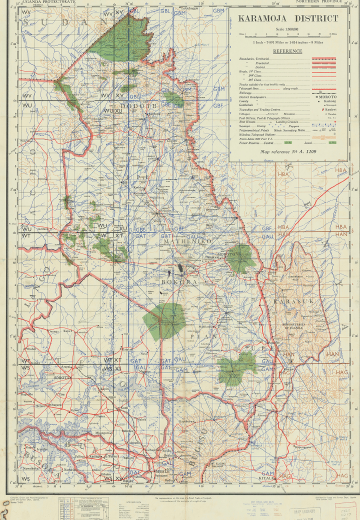
Much of the historiography on marginality and belonging in colonial and postcolonial Africa takes the political, military, and economic dominance of the state for granted. The case of Karamoja at the moment of independence, however, offers a glimpse at how these concepts took shape in a region where state sovereignty was questionable at best and where indigenous political, economic, and military institutions remained capable of competing with the state, even within spaces considered centers of government authority. The developmentalist drive of the 1950s saw the British authorities attempt to engineer Karamoja's political and economic incorporation into the Ugandan state (see Fig. 1, below), even as colonial officials remained skeptical of the ability of the Karamojong to integrate into party politics and other hallmark systems of Uganda's impending independence. Ordinary people in Karamojong communities, on the other hand, worked to combat increasingly invasive development interventions, while local elites chafed under their exclusion from the political process and the condescension they received from the British authorities and anticolonial Ugandan leaders alike.
Karamoja District.
Karamojong elites would get their first major opportunity to participate in national politics with the Africanization of the LegCo in 1958, a milestone which coincided with the passage of increasingly draconian legislation intended to curb the growing indigenous power that challenged state authority in Karamoja. Between 1958 and 1966, government officials, local elites, and ngitunga a ngireria took to state spaces to advocate for their vision of Karamoja's future. At political rallies, bars, and council meetings, Karamojong elites sought to establish their region as a viable, respectable political constituency that could participate equally in postcolonial identity politics. By contrast, government policymakers saw Karamoja as a special district and enshrined its uneasy place in independent Uganda with legislation like the Karamoja Act of 1963. Meanwhile, in barazas, peace meetings, and towns, ngitunga a ngireria demonstrated that, even as they were willing to productively engage with state institutions, their own indigenous sociopolitical epistemologies continued to hold sway in the region.
In April 1966, the Karamoja Act was repealed; Karamoja now shared the same legal status as any other district in Uganda. This did not signify, however, a change in policymakers’ attitudes towards Karamoja, nor did it herald a change in the influence wielded by Karamojong elites or in perceptions of the state among ordinary people as violent and capricious. Rather, the oppositional relationship between the state and indigenous structures of power in the countryside hardened. Over the course of the 1970s, automatic weapons became more readily available in Karamoja, enabling raiders to confront government forces more directly and communities to prevent state interference in centers of indigenous authority.
Government officials, meanwhile, believed themselves to be waging “a war of survival against backwardness and underdevelopment in Karamoja.”Footnote 120 Archival documents from the late 1960s onwards demonstrate a heightened use of terms such as “tribesmen” and “natives” to describe ngitunga a ngireria, echoing the language of colonial conquest and governance. As the 1960s gave way to the 1970s, official reports seethed with contempt for ngitunga a ngireria who adhered to their own traditional lifestyles and modes of dress, which officials saw as a humiliating blow to Uganda's respectability. “Tourists still take a scornful pride in photographing naked Ugandans from Karamoja,” one official wrote resentfully in 1967, while ten years later, a committee described Karamojong homesteads as “a harbor for all filth” and “breeders of raiders.”Footnote 121 These prejudices, rooted in colonial racism, came to their horrific conclusion under the regime of Idi Amin, when soldiers massacred scores of civilians at Nawaikorot for refusing to adopt Western clothing.Footnote 122
It did not have to be thus. As we have seen, communities in Karamoja were willing and able to peacefully incorporate state institutions such as the market economy and state spaces such as towns into local networks of socioeconomic and political relations, especially when these offered tangible benefits, as the Somali merchant Lonyangkook did to the Jie people during the hunger of 1961. Yet government approaches to Karamoja remained inflexible, defined by xenophobic colonial outlooks that designated force as the best method for dealing with the region's people. While a focus on state spaces between 1950 and 1966 reveals a contest between indigenous institutions and those of the state, it also offers a glimpse at possibilities for coexistence — at how the people of Karamoja might have been able to find a sense of belonging within the fledgling Ugandan state on their own terms, had they been allowed to do so.
Acknowledgements
Many thanks to Prof. Neil Kodesh, Prof. Emily Callaci, and my fellow graduate students at the University of Wisconsin-Madison — Ayodeji Adegbite, Tolulope Akinwole, Leslie Sabakinu, Michael Oshindoro, and Theophilus Okunlola — for their constructive criticism. The editors of the JAH and the three anonymous reviewers also provided invaluable feedback as I revised the article. Special thanks go to Kapel Daniel Abual in Kotido and the staff of the Uganda National Archives in Kampala for their crucial contributions to the research, as well as to the people in Karamoja who shared their recollections with me.


 Open access