


Archaeological communities have been approached in a variety of ways in previous studies, and researchers recognize the challenge in linking the archaeological record with the social concept of community (Canuto and Yaeger Reference Canuto and Yaeger2000; Isbell Reference Isbell, Canuto and Yaeger2000; Kolb and Snead Reference Kolb and Snead1997; Rautman Reference Rautman2014; Varien and Potter Reference Varien and Potter2008; Wills and Leonard Reference Wills and Leonard1994; Young and Herr Reference Young and Herr2012). The variable ways used to reconstruct past communities usually derive from the scale at which those communities are examined and the data available to reconstruct them. Early studies often focused on the environmental and economic foundations of communities, especially subsistence regimes that emphasized factors such as resource density, arable land, and water (for example, Doyel’s [Reference Doyel, David and Plog1980] Hohokam irrigation communities). More recent studies have addressed the social aspects of community development, highlighting interaction networks and day-to-day social strategies and recognizing that communities were dynamic and socially constructed (Yaeger and Canuto Reference Yaeger, Canuto, Canuto and Yaeger2000:4). As the nexus of social interaction, communities exhibit social identities that can alternately have rigid or flexible boundaries.
Although most researchers agree that communities must be evaluated using contextual data, the challenge continues to be linking material remains—such as architecture, ritual structures, other features, and artifacts and their placement on the landscape—to social processes that led to interaction, community development, and identity formation. Kolb and Snead (Reference Kolb and Snead1997) noted that communities are the result of local histories, but sometimes it is difficult to reconstruct that history, especially in areas where long-term commitments to specific land and landforms lead to generational rebuilding.
This is the challenge that has faced researchers working in the Mimbres River Valley of southwestern New Mexico, where many of the largest sites were occupied for hundreds of years. These large sites are often labeled as the center of communities based on their location and long-term occupations (Anyon and LeBlanc Reference Anyon and LeBlanc1984; Shafer Reference Shafer2003; Stokes Reference Stokes and Robert2019), but what those communities looked like and how they interacted has not been investigated to fully evaluate community development, change, and longevity.
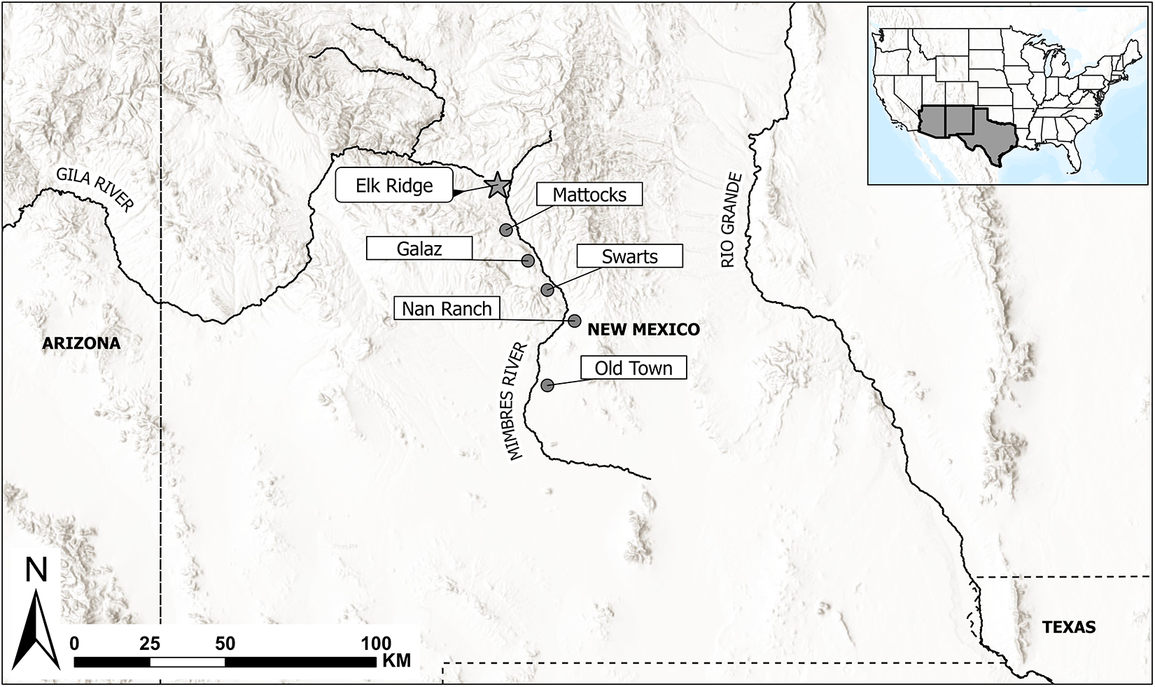
In this article, we explore community development, predominantly during the Classic Mimbres period (AD 1000–1130), using the Elk Ridge pueblo and surrounding sites in the northern portion of the Mimbres River Valley as a case study (Figure 1). Elk Ridge was the most northerly large pueblo in the Mimbres River drainage, and it had a significant—although not well defined—Late Pithouse period (AD 550–1000) component. The presence of variably sized sites surrounding Elk Ridge pueblo potentially associated with its occupation offered an opportunity to examine the nature and composition of the local community and to explore the social relationships between these sites and sites within the broader Mimbres region. This allowed us to investigate how landscape, location, kin relations, exchange networks, and ritual activities linked groups in the past and how these translated into a social community similar to those we see throughout the US Southwest and elsewhere in the Neolithic world.
Elk Ridge pueblo location in the Mimbres region (map by Danielle Romero).

What Is a Community?
As noted above, definitions of communities have varied, and communities are acknowledged to have been dynamic. Adler (Reference Adler, Mark and Richard2002a:26) notes that “in practice, the community is always in the process of being defined and redefined based on emigration, immigration, relationships with surrounding local populations, histories of land use, and conflict.”
The definition of a community is contingent on the scale at which it is defined, given that local communities tend to be more spatially constricted, whereas regional communities can be extensive and are often represented by larger settlement systems (Wills and Leonard Reference Wills and Leonard1994). In the US Southwest, definitions of local communities usually involve a spatial component, with communities bounded on certain points on the landscape, sometimes represented by large villages but also by multisite clusters composed of sites of varying sizes (Adler Reference Adler, Mark and Richard2002a; Fish et al. Reference Fish, Fish and Madsen1992; Varien Reference Varien1999; Wallace Reference Wallace and Wallace2011). These site clusters often have communal architecture, such as kivas or plazas, suggesting that they represent an integrated community.
We take the premise that social interaction underlies the concept of community (Varien and Potter Reference Varien and Potter2008; Yaeger and Canuto Reference Yaeger, Canuto, Canuto and Yaeger2000). Yaeger and Canuto (Reference Yaeger, Canuto, Canuto and Yaeger2000) highlight the social characteristics of a community in their discussion of interactional communities, which emphasizes proximity and shared experiences. Most definitions of local communities focus on day-to-day interaction. These communities shared a social identity based on this regular interaction and associated ritual activities, resulting in what Kolb and Snead (Reference Kolb and Snead1997) refer to as self-identification. Yaeger and Canuto (Reference Yaeger, Canuto, Canuto and Yaeger2000:7) caution that multiple identities can exist within a single community based on gender, kinship (lineage), and ethnicity (see also Hegmon Reference Hegmon, Mark and Richard2002). Although we recognize that this occurred in the Mimbres region, we argue that a common community identity can override other identities to avoid the development of factions.
Isbell (Reference Isbell, Canuto and Yaeger2000) has contrasted the natural community—defined by shared residence and shared life experiences, which he sees as a static and homogeneous concept—with the more evasive “imagined” community. This imagined community crosscuts the more traditionally defined bounded community of groups with collective consciousness and instead gives preference to competing discourses and the dynamic, contingent, and contradictory nature of social interaction (Isbell Reference Isbell, Canuto and Yaeger2000:245). Because of the difficulty in operationalizing this concept using archaeological data, we focus here on the social interaction model of community (but see Schachner Reference Schachner, Mark and James2008).
Communities also served economic functions, especially in regions where land tenure and water rights were important (Adler Reference Adler1996). Communities negotiated and mitigated access to resources such as land, water, and labor. This is especially pertinent to the Mimbres River drainage, where expanses of arable land are constrained by the ecological setting and access to water. Access to arable land and irrigation water rights would have been negotiated within each local community and among different communities throughout the valley (Anyon and LeBlanc Reference Anyon and LeBlanc2024). Communities also participated in local and regional exchange networks that enabled access to food, goods, and nonlocal resources. This exchange was variably organized, sometimes at the household level, sometimes at the community level. In the Mimbres region, exchange has been best documented using ceramic data (Creel Reference Creel2022; Creel and Speakman Reference Creel, Speakman, Roth, Gilman and Anyon2018), although food, cotton, and fauna were also exchanged. Materials exchanged beyond the regional level include obsidian, shell, and turquoise.
Defining the Elk Ridge Community
In this article, we consider the extent and structure of the Classic Mimbres Elk Ridge local community, the relationship between this community and other Classic Mimbres communities in the Mimbres River Valley, and the relationship between the Elk Ridge community and the greater Mimbres region—and beyond. We define the local community as consisting of individuals, families, and other social groupings who were interacting on a regular face-to-face basis (following Varien Reference Varien1999:19 and others). We therefore see spatial and social boundedness to the community. We assume that successful social relations were essential to a functioning community, and we recognize that land and water rights were a fundamental component of community development and cohesion (Adler Reference Adler1996). Through social interaction, the occupants of the Elk Ridge community negotiated access to resources, labor, rituals, and marriage.
We use multiple lines of evidence to reconstruct the Elk Ridge community. These include the site’s location within the Mimbres Valley and its relationship to surrounding sites, pueblo architectural data, mortuary data, and material culture—primarily ceramics and fauna. These lines of evidence provide information about the organization of the Elk Ridge community and those who were most likely involved in the day-to-day interaction that we see as representing the local community.
Elk Ridge participated in a wider Mimbres regional community, which involved exchange, intercommunity movement, and intermarriage with other pueblos in the Mimbres and Gila River Valleys. This resulted in a shared regional identity represented by shared ceramic production techniques and styles, burial practices, and architecture (Gilman et al. Reference Gilman, Creel, Gruber, Roth, Gilman and Anyon2018; Hegmon et al. Reference Hegmon, Russell, Baller, Peeples and Striker2021). The Classic period Mimbres are known for their distinct decorated black-on-white bowls with geometric and representational motifs, incorporating animals, birds, insects, and humans (Hegmon et al. Reference Hegmon, McGrath, F. Michael O’Hara, Russell, Roth, Gilman and Anyon2018). Burial practices are also part of this regional identity, given that many burials were placed in a flexed position beneath pueblo room floors. Burials were often accompanied by a ceramic bowl with a kill hole (an intentional puncture, usually in the center of the vessel) placed over the head. Pueblo room construction comprises the final part of this regional identity, with most pueblo walls constructed using local river cobbles placed in adobe. Mimbres pueblos were built by accretion versus as preplanned room blocks, and this is visible in substantial remodeling at the larger, longer-occupied pueblos.
Finally, Elk Ridge also participated in a broader community that involved exchange and intermarriage with groups outside the valley. We assess this broader community primarily through ceramic data, although mortuary data from Elk Ridge has been critical in establishing connections with Upland Mogollon groups outside the main valley (Romero Reference Romero2024; Roth et al. Reference Roth, Romero and Creel2022).
Elk Ridge Pueblo
Elk Ridge pueblo is located in the northern portion of the Mimbres River Valley as it transitions to the west toward Sapillo Creek and the Gila River Valley (Figure 1). It is the farthest north of the large Classic period pueblos in the Mimbres Valley. We estimate that there are 200+ rooms at the site across multiple room blocks, and it is therefore comparable in size to the other large pueblos that have been investigated in the Mimbres region over the past century (Gilman et al. Reference Gilman, Creel, Gruber, Roth, Gilman and Anyon2018).
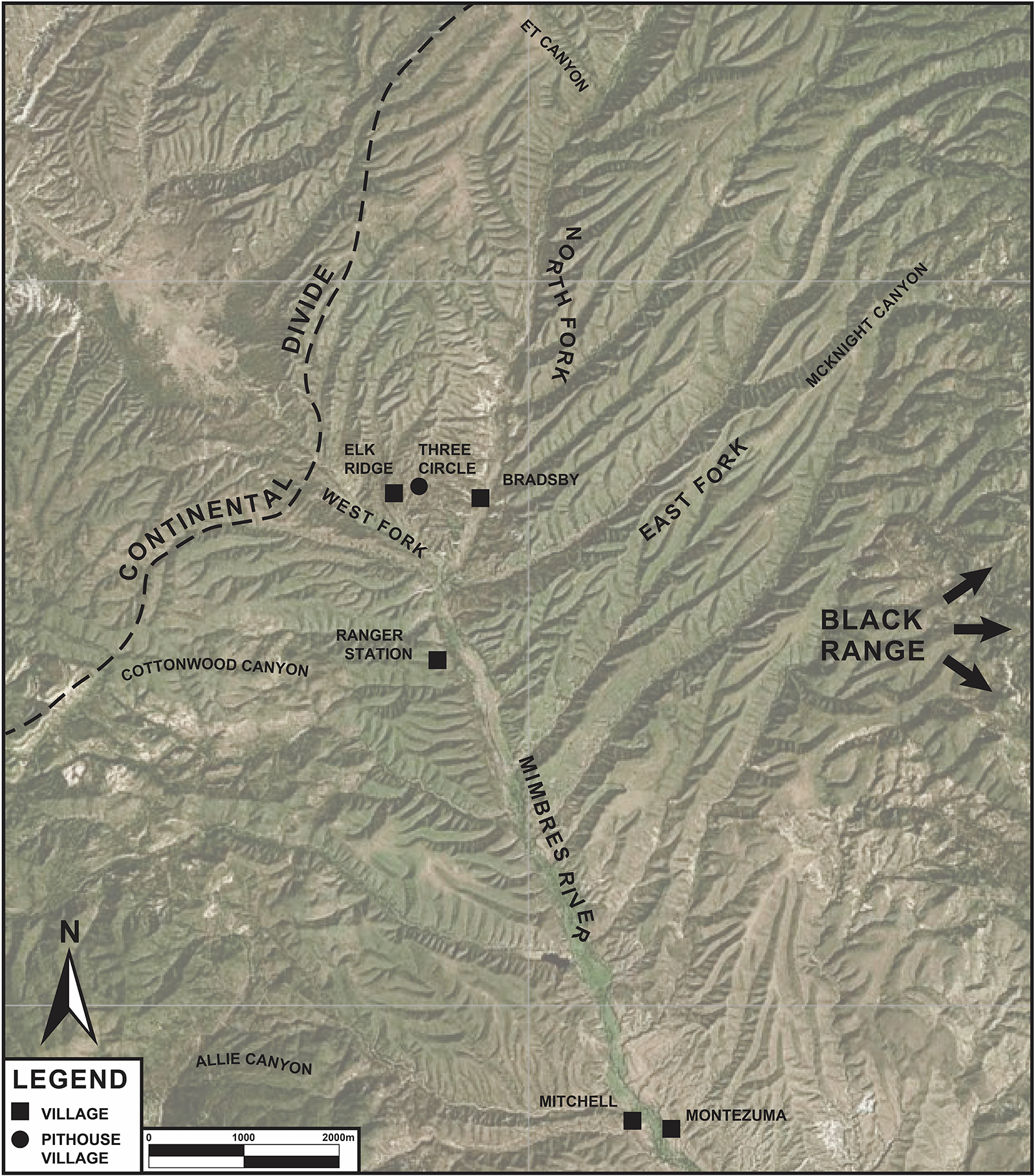
The pueblo is close to the confluence of the North, East, and West Forks of the Mimbres River (referred to as the Three Forks), from which point the main stem of the river flows south. It differs from other large pueblos to the south—such as Galaz (Anyon and LeBlanc Reference Anyon and LeBlanc1984), Swarts (Cosgrove and Cosgrove Reference Cosgrove and Cosgrove1932), and Mattocks (Gilman and LeBlanc Reference Gilman and LeBlanc2017)—in that it is not located on a terrace next to the river but is instead on an alluvial fan to the west of the main river channel. We believe that two significant factors conditioned its location: a nearby spring and its ancestral pithouse village. The pueblo is located 250 m downstream from Laney Spring, reputed to be reliable in modern times (Trauger Reference Trauger1972:189; White and Kues Reference White and Kues1992:66). This was more than enough water to supply the daily minimum needs of the Classic period population of Elk Ridge pueblo.
We also see the proximity of the Three Circle pithouse village as influencing the location of the pueblo. The Three Circle site is located on a mesa that sits between the West and North Forks of the Mimbres River, about 50 m above Elk Ridge pueblo. It has approximately 100 pithouses—based on the number of pithouse depressions observed on the site surface—and some of the larger depressions may be great kivas. Given its proximity to Elk Ridge and the lack of a pueblo component at the site, we envision that many of the households living at the Three Circle site moved to Elk Ridge at some point during the Three Circle phase (AD 750–1000), possibly as commitment to irrigation agriculture increased and it became necessary to be closer to agricultural fields. Any land use and water rights established while people occupied the Three Circle site could easily have been maintained by their descendants living at Elk Ridge pueblo, given the proximity of the two settlements. The move from the mesa top may have been partially driven by the desire to locate next to and to control a reliable spring.
Elk Ridge pueblo became an important central locality during the Three Circle phase, much like Harris, Galaz, Swarts, NAN Ranch, and Old Town to the south. Based on the recovery of Three Circle phase ceramics and Transitional phase pithouses (Berryman and Laumbach Reference Berryman, Laumbach and Lonnie2019; Roth Reference Roth2018), we posit that the population of Elk Ridge increased substantially by the latter part of the Three Circle phase, given that groups moved there from the Three Circle site and possibly from other pithouse sites in the vicinity. A large late Three Circle phase great kiva outlined during work in the southern part of the site (Berryman and Laumbach Reference Berryman, Laumbach, Lonnie and Michael2023) may have been one of the draws to Elk Ridge, and those living in smaller nearby sites may have participated in social and ritual activities associated with the great kiva. Consequently, local community development began before pueblo construction, and those social ties were maintained across the pithouse-to-pueblo transition.
Pueblo Component
Excavations of Elk Ridge pueblo have been done both in the northern and southern portions of the site. The southern part of the site—on private land that is now owned by the Archaeological Conservancy—was mechanically looted by a previous landowner prior to the implementation of the 1989 New Mexico state burial law. Salvage excavations were done by William Russell and archaeologists from Human Systems Research, which provided valuable data on the occupation of this portion of the site (Laumbach Reference Laumbach2006). Berryman and Laumbach (Reference Berryman, Laumbach and Lonnie2019) report excavations within 41 rooms (14 complete and 27 partially excavated rooms) and 17 burials. These included habitation rooms, turkey pens, and a possible Classic period kiva.
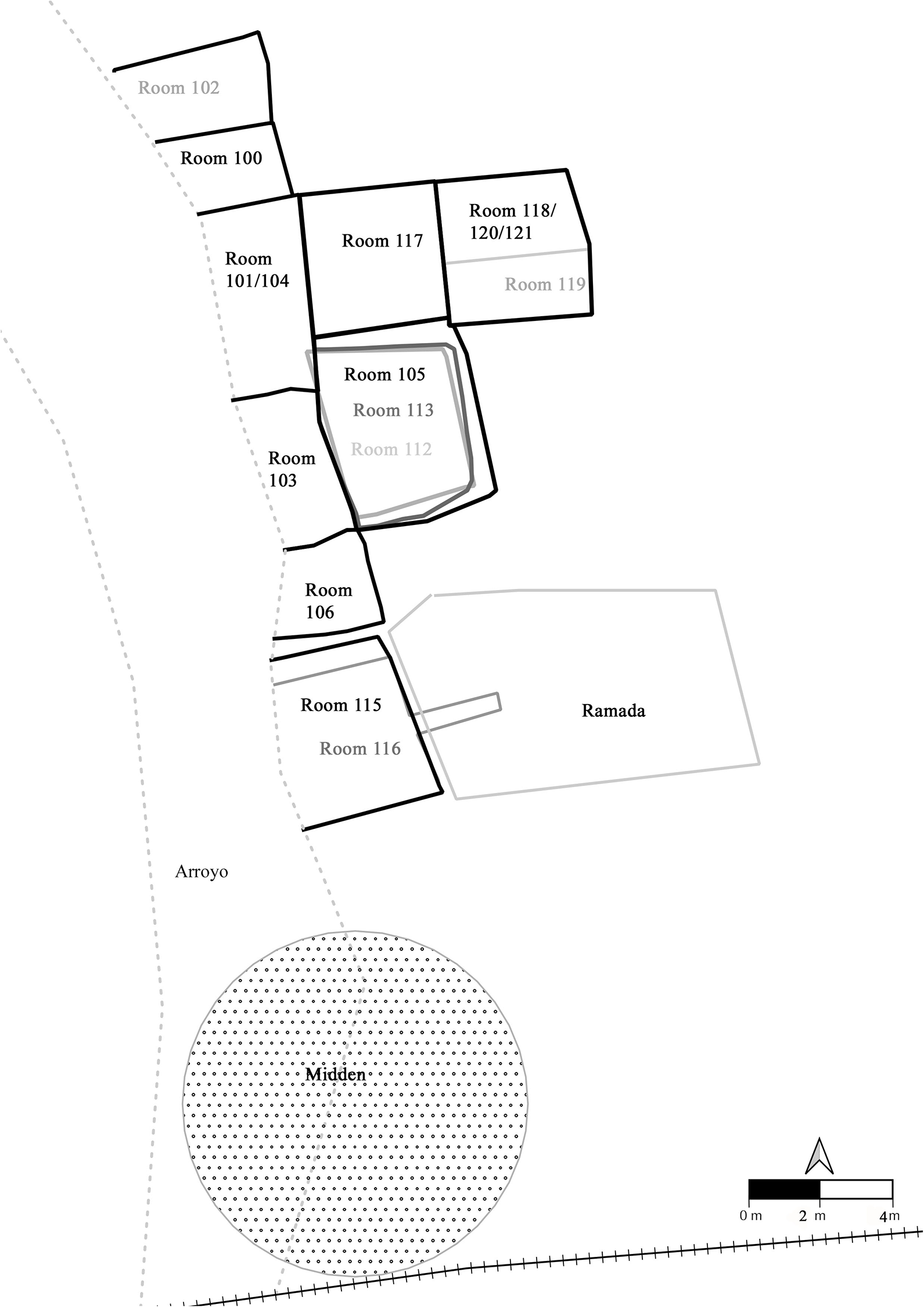
The northern portion of the site was protected by alluvial deposition until erosion from an arroyo exposed numerous pueblo rooms and associated features on the west side of the site (Figure 2). University of Nevada Las Vegas (UNLV) conducted excavations along the arroyo cut prior to the installation of gabions along the arroyo to prevent further erosion (Roth and Creel Reference Roth, Creel, Lonnie and Michael2023). This work documented 17 pueblo rooms (with 2–3 additional rooms provisionally identified but destroyed by later remodeling), a turkey pen, a burned ramada, a midden, several extramural surfaces, and 41 burials.Footnote 1
Elk Ridge site map; UNLV’s work (map by Danielle Romero).

These excavations document the sequence of pueblo construction at the site, with evidence of superimposed Classic period room blocks, including an earlier component with coursed adobe construction followed by the more typical cobble-adobe wall construction (Roth and Creel Reference Roth, Creel, Lonnie and Michael2023). Superpositioning was apparent in many of the pueblo rooms and often involved changing hearth alignments, the sealing and moving of doorways, and blocked vents. Habitation rooms often had multiple burials, indicating long-term connections to the site.
Within the pueblo, community development occurred as described elsewhere in the valley, most notably at NAN Ranch (Shafer Reference Shafer2003, Reference Shafer, Valli and Patricia2006). Land-holding families constructed initial “core” rooms that were added to, remodeled, and subsequently disused (and sometimes then rebuilt), most likely in response to family dynamics as families grew, people married, and people moved. We see this in the presence of room suites consisting of habitation and associated storage rooms (following Shafer Reference Shafer2003) that were remodeled to accommodate more rooms, interpreted as extended-family corporate groups. The “core” rooms in these extended-family households at Elk Ridge had distinct two-compartment, slab-lined hearths and usually had multiple burials. Extramural areas were also remodeled through time, including a burned ramada associated with an extramural surface and turkey pen, which were built over earlier adobe component pueblo rooms (Roth Reference Roth2018).
Topography, Drainages, and Agricultural Potential
The Elk Ridge community must be examined within the landscape in which it was located, given that this structured the economy and either facilitated or impeded interaction. As noted, the pueblo is located in a distinct setting on alluvium west of the main Mimbres River channel. It and smaller sites that we infer to be part of the local community encompassed four primary reaches of the Mimbres River drainage system: the North, East, and West Forks and the main stem reach, located immediately downstream from the confluence of the Three Forks (Figure 3). Each reach has different environmental characteristics, which are reflected in the site distributions.
Elk Ridge community agricultural land (map by Scott Nicolay).

Both the North and East Forks originate in the upper reaches of the Black Range, an area of greater rain and snowfall than the Continental Divide, which is where the West Fork ends. Valley bottoms of varying sizes suitable for agriculture are present in these river reaches: the North Fork is 50 ha, the East Fork is 24 ha, and the West Fork is about 29 ha. Downstream and south of the Three Forks’ confluence, the main stem of the Mimbres River starts as a narrow 0.8 cm channel that then opens up for the next 4 km into a wide valley bottom. This main river reach contains 72 ha of flat river bottomland.
Although it is not possible to know the characteristics of water availability during the Classic period, Trauger (Reference Trauger1972:50), using information obtained prior to extensive modern residential well drilling, reported that surface water was present near the upstream end of the main Mimbres River–channel valley bottom. Upstream from this point, the water table ranged from surface to a meter below surface. We interpret this to indicate that bottomland agriculture would have been eminently feasible within the Elk Ridge community during the Classic Mimbres period, possibly including ditch irrigation in the main stem reach.
Three additional variables would have affected agricultural potential. First, alluvial soils in the West Fork and the main river stem are less rocky than those in the North and East Forks, possibly increasing their per-hectare productivity. Second, the potential for catastrophic flooding is lower in the West Fork than the other forks due to its watershed characteristics. The third factor is the number of frost-free days, a factor applicable to the entire Elk Ridge community. Graybill (Reference Graybill1975:56) reported between 100 and 110 frost-free days at the upper community area elevations (as defined in Figure 3), which is adequate for agriculture. Even so, this range of frost-free days combined with greater potential for early or late killing frosts and a greater potential for cold-air drainage would make agriculture somewhat more tenuous in this area than in other lower-elevation portions of the Mimbres River Valley.
The Local Elk Ridge Community
We see the Classic period Elk Ridge local community as encompassing a group of large and small sites that regularly cooperated, shared resources, and operated as a unit. The community was anchored in two large pueblos: Elk Ridge and the Ranger Station site (also referred to as Cottonwood pueblo). Elk Ridge is the larger of the two, estimated to contain at least 200 rooms, whereas Ranger Station pueblo is estimated to contain between 100 and 120 rooms (Nicolay and Roth Reference Nicolay and Roth2023; Stokes Reference Stokes2003). Elk Ridge has a substantial Late Pithouse occupation, particularly during the late Three Circle phase, as evidenced by domestic architecture, ceramics, and the presence of a great kiva (Berryman and Laumbach Reference Berryman, Laumbach and Lonnie2019, Reference Berryman, Laumbach, Lonnie and Michael2023). The Late Pithouse occupation at Ranger Station, on the other hand, is limited (Nicolay and Roth Reference Nicolay and Roth2023). Another broad distinction between these two sites is apparent in occupational complexity. Elk Ridge has evidence of repeated, superimposed Classic Mimbres construction episodes akin to large pueblos such as Swarts (Cosgrove and Cosgrove Reference Cosgrove and Cosgrove1932) and NAN Ranch (Shafer Reference Shafer2003) to the south. Ranger Station pueblo appears to exhibit substantially less stratigraphic complexity, with limited visible evidence of remodeling and superimpositioning of rooms, although this has not been confirmed by excavation. We interpret these differences, and others discussed below, to indicate that Elk Ridge pueblo was the primary Classic Mimbres settlement in the community.
Stokes (Reference Stokes2003; Reference Stokes and Robert2019) used survey data to evaluate what he refers to as community systems along the major drainages in the Mimbres Valley. These spatially distinct communities developed along specific reaches of the river and its tributaries, and consisted of large sites surrounded by smaller farmsteads and field houses. He reevaluated previous survey data collected by Graybill (Reference Graybill1975) in the area around Elk Ridge and identified two community systems pertinent to our study. It is important to note that he defined these community systems prior to our work at the Elk Ridge and the Ranger Station sites. He identified one community around Elk Ridge, which included Elk Ridge pueblo, four farmsteads, and 25 field houses, and a second around Cottonwood / Ranger Station, with the main pueblo surrounded by three farmsteads and seven fieldhouses (Stokes Reference Stokes2003). We have included the Ranger Station site and its satellites as part of the Elk Ridge community in our study.
Ranger Station Pueblo
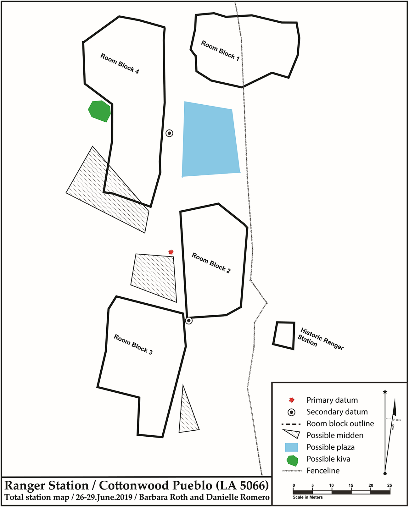
Ranger Station pueblo is located on the first bench above the main stem of the Mimbres River floodplain on the west side of the river and on the south edge of Cottonwood Canyon (Figure 3). It is approximately 0.8 km downstream from the Three Forks’ confluence and just north of where the valley bottom opens up into a potentially irrigable floodplain. The site was heavily looted over many decades, but some archival information is available on artifacts recovered during past looting activities. UNLV’s work there involved mapping and on-site artifact recording within a series of 10 × 10 m units to evaluate the size of the pueblo and the temporal span of occupation (Nicolay and Roth Reference Nicolay and Roth2023). The project also incorporated data from earlier, mostly unpublished reports.
Surface ceramics and archival data indicate that the Ranger Station site was primarily occupied during the Classic period, with limited evidence of an earlier Pithouse period occupation. Given the lack of a significant Pithouse period component, it does not appear that groups initially moved to site during the Three Circle phase, as documented at the Elk Ridge site.
We estimate that the pueblo has 100+ rooms within four distinct Classic period room blocks (Figure 4). Our knowledge of the nature and function of the rooms within the pueblo is limited given the degree of looting. The size and location of Room Block 3 on Figure 4 suggest that it was the earliest room block built at the site and therefore may represent the founding lineage. The similarity in the room blocks in construction techniques and artifacts suggests that if groups were moving into the site as it grew, they shared the general Mimbres identity common to pueblo groups throughout the valley.
Ranger Station pueblo (map by Scott Nicolay). (Color online)

Ranger Station pueblo may have been built to take advantage of where the underflow of the Three Forks becomes the surface flow of the Mimbres River. This location would have been the uppermost point along the main stem of the Mimbres River, where irrigation ditch headgates could have been placed. This gave residents of the pueblo control of the irrigation infrastructure in this uppermost flat valley bottom. As noted above, we believe that the inhabitants of Elk Ridge pueblo focused their agricultural pursuits in the 103 ha of valley bottomland along the Three Forks.
With no other nearby major villages located to the south, Ranger Station pueblo likely controlled water and agricultural land in this area. This pattern continues at several other locations down the valley to the south, with communities located where they could control floodplains just south of constrictions (Anyon and LeBlanc Reference Anyon and LeBlanc2024). If the founding occupants of the Ranger Station site had community ties to Elk Ridge, as we discuss below, then the pueblo may have been built to control that southern confluence. This would have further solidified the connection between Elk Ridge and Ranger Station pueblos.
Surrounding Pueblos
The local Elk Ridge community included people occupying nearby sites. Surveys in the area have documented a range of sites of varying sizes with structural rubble, artifact scatters, and other material evidence of human landscape use. We infer that sites with structural rubble reflect the most intensive land use by a community largely dependent on cultivated foods, wild plants that thrive in cultivated fields, and nut- and seed-bearing plants in the local vicinity. These site types have also experienced the most archaeological investigations and therefore provide the greatest material-culture interpretive value.
The distribution of Classic Mimbres sites with structural rubble along the Three Forks is known from work by Peckham (Reference Peckham1970), Graybill (Reference Graybill1973, Reference Graybill1975), and more recent cultural resource management surveys (Mead et al. Reference Mead, Purcell, Greenwald, Davis, Cozby and Wimberly2012; Schoonover et al. Reference Schoonover, Blanton, Mills and Meade2010). These sites generally have fewer than five rooms and likely represent field houses rather than habitation sites, although no systematic investigations have been done at them, so that conclusion remains speculative. A few 10- to 20-room pueblos have been reported, and these may have been occupied more permanently (Stokes Reference Stokes2003).
In Table 1, we have taken Graybill’s (Reference Graybill1973, Reference Graybill1975) published site data for his Period B (Classic Mimbres) sites with structural rubble and, using his recorded rubble area, we have roughly translated this into room counts by dividing that area by an average Classic Mimbres room size of 15 m2 (Anyon and LeBlanc Reference Anyon and LeBlanc1984; Stokes Reference Stokes2003). We have also included newly recorded information from the North Fork (Schoonover et al. Reference Schoonover, Blanton, Mills and Meade2010).
Site Sizes and Estimated Rooms along the Three Forks, Excluding Elk Ridge Pueblo.

As may be expected, Classic Mimbres settlement distributions along the West, North, and East Forks differ based on the drainage characteristics (Table 1). The majority of masonry rubble sites within the West Fork drainage have fewer than 10 rooms each, with most having fewer than three rooms. These small sites are scattered widely throughout the drainage. Site size distribution along the East Fork is similar to the West Fork, but the distribution is linear due to the narrowness of the East Fork valley bottom. The North Fork contains small sites, but it is also the only drainage with a larger site size class. The North Fork has almost twice as many rooms as the West and East Forks, which may be due to the fact that the North Fork includes almost twice the arable valley bottomland as either the West or East Forks and more than twice the watershed area.
Stokes (Reference Stokes2003) classified sites with more than 17 rooms as pueblos that were most likely permanently occupied (large farmsteads). With the exception of Elk Ridge pueblo, this would mean that at least 15% of the rooms along the West and East Forks and at least 42% of the rooms along the North Fork were farmsteads. Once again, the importance of the North Fork is notable within the Elk Ridge community. Stokes et alia (Reference Stokes, Woods, Toney, Roth, Gilman and Anyon2018) proposed that some larger (10+ rooms) sites in their study of small sites in the Mimbres region served to mark land tenure, and that these farmsteads may have served as land markers for the Elk Ridge local community.
We conservatively estimate that the Elk Ridge community along the Three Forks had approximately 200 rooms at Elk Ridge pueblo, with minimally an additional 654 rooms in smaller sites, all of which were within daily commuting distance of Elk Ridge pueblo. The approximately 500 rooms in sites smaller than 17 rooms, many of which contained fewer than 10 rooms, were either seasonal or short-term occupations, and most are probably field houses (following Stokes et al. Reference Stokes, Woods, Toney, Roth, Gilman and Anyon2018). We acknowledge that the community boundaries reflecting wild food gathering and hunting would have been much larger than the area used for agriculture, but it appears that people lived in proximity to agricultural land and therefore spent most of their daily lives interacting and living with their fellow community members along the major valley bottoms.
Surface survey is much more limited southward and downstream from the Three Forks as the river flows past the Ranger Station site toward Allie Canyon. Two 8- to 10-room pueblos have been recorded between the Three Forks confluence and Ranger Station pueblo, and two more of the same size were recorded within 1.3 km south of the site. Nine sites of one to three rooms have been recorded between Ranger Station pueblo and Allie Canyon; these fit the general designation of field houses. Of significant interest is a site estimated to be between 20 and 40 rooms located approximately 3 km south of the Ranger Station site (Laumbach Reference Laumbach1979; Mead et al. Reference Mead, Purcell, Greenwald, Davis, Cozby and Wimberly2012). This site appears to be the second largest pueblo on this river reach; it is situated toward the southern end of this section of wide valley bottomland, whereas Ranger Station pueblo is at the northern end. Perhaps these two settlements anchored the occupation and use of this river reach.
Ceramics
The local Elk Ridge community can also be reconstructed using ceramic data, which document the use of shared clays and design styles. The relationship between the Elk Ridge and Ranger Station pueblos is clearly illustrated by ceramic data, which show that Ranger Station pueblo was part of the Elk Ridge community. Creel (Reference Creel2022) reports that of 42 nonlocal vessels sampled for instrumental neutron activation analysis (INAA) from Elk Ridge, 11 are sourced to the Ranger Station site—the highest number of vessels at Elk Ridge from any outside source. An additional 94 vessels from Elk Ridge were sampled for INAA (Romero Reference Romero2024), and eight of these are sourced to the Ranger Station site. These vessels included three corrugated jars, two painted jars, and three painted bowls, two of which were from burials.Footnote 2 Two of the bowls have similar design characteristics, suggesting that they were produced by the same potter.
Perhaps most interesting is the similarity of one of the painted jars sourced to the Ranger Station site to a jar sourced to Elk Ridge. Both jars were recovered from a smashed vessel cache in Room 117 at Elk Ridge; this cache has been interpreted as part of the ritual closure of that room (Roth and Creel Reference Roth, Creel, Lonnie and Michael2023). Similarities in design and manufacturing point to both being made by the same individual, but one is sourced to Ranger Station and the other to Elk Ridge (Romero Reference Romero2024).
The relationship between the Ranger Station and Elk Ridge pueblos is also apparent in INAA data from the Ranger Station site. A total of 23 Classic period vessels recovered from the Ranger Station site have been sourced. Of these, seven were from the Ranger Station source, and eight were from Elk Ridge sources (Creel Reference Creel2022). These data suggest that although individuals at the Ranger Station site were making a significant amount of their own pottery, they were also reliant on Elk Ridge for some pottery.
Given the proximity of the Elk Ridge and Ranger Station sites to each other, the INAA data, and the presence of vessels inferred to have been made by the same potter from both Elk Ridge and Ranger Station sources, we infer that potters at these two sites were sharing clay sources. Sharing resources is one of the characteristics used to define communities (Adler Reference Adler1996). The recovery of two vessels—likely made by the same potter—in a ritual cache in Room 117 at Elk Ridge indicates that the potter had a strong relationship with both Elk Ridge and Ranger Station and further supports the inference that these sites were part of an interacting community. This also illustrates the importance of communities of practice in building community relationships. Because women are considered to have been the primary potters in past pueblo societies (Crown and Wills Reference Crown and Wills1995), women potters likely helped build relationships between sites within the Elk Ridge community, both in production and exchange. These relationships reinforced social connections across the community and enhanced communication and cooperation.
Ceramic data also indicate that the Bradsby site was part of the Elk Ridge community. The site consists of a small five-room pueblo and a small semisubterranean Classic period kiva located on a small knoll overlooking the North Fork approximately 1 km upstream of the Three Forks confluence (Anyon and LeBlanc Reference Anyon and LeBlanc2024). Creel’s (Reference Creel2022) analysis of nine ceramic vessels from Bradsby showed that five were from Elk Ridge and two were from the Ranger Station site. Ceramic exchange therefore documents the integral relationship between the Bradsby site and the Elk Ridge local community.
Ritual
We see Elk Ridge pueblo as the ritual center of the Elk Ridge community—the place where local disputes and intracommunity tensions were negotiated and defused, the locus of community integration, and the focus of ancestor veneration that solidified family and clan access to critical resources such as water and arable land. Small kivas, special rooms, and plazas played a critical role in community integration during the Classic period throughout the Mimbres Valley and at Elk Ridge. The recovery of multiple large decorated bowls from an excavated ramada at Elk Ridge inferred to represent feasting activities (Roth Reference Roth2018) suggests that community integration was accomplished using a variety of ritual activities. Village- and community-wide activities such as dances and large-scale feasts most likely took place in open plazas.
Not all ritual activities were located at Elk Ridge pueblo. The Bradsby site had a 16.2 m2 Classic Mimbres semisubterranean kiva (Anyon and LeBlanc Reference Anyon and LeBlanc2024). This kiva is unusual because there were ancestral burials associated with it. The subfloor burials consisted of children and adults—both male and female—with associated funerary items, such as killed Classic Mimbres black-on-white bowls, similar to those found in many subfloor Classic period room contexts throughout the Mimbres region. The kiva was ritually retired before the end of the Classic Mimbres period. The roof appears to have collapsed directly onto the floor without burning, after which Classic period trash was thrown into the depression, likely from the adjacent Classic period rooms. At some point, an adult female accompanied by a partial smudged bowl was interred into this trash deposit but not into the kiva roof fall (Anyon and LeBlanc Reference Anyon and LeBlanc2024).
This small kiva must have in some way been associated with Elk Ridge pueblo, given that it is clearly located within the Elk Ridge community boundaries, and the smudged bowl associated with the abovementioned burial sourced to Elk Ridge (Creel Reference Creel2022). We are unsure of its purpose, other than ritual. It could have had special significance within the Elk Ridge community. Perhaps a particular family who resided here had special responsibilities within the community. It is also possible that this kiva was placed to mark the unique significance of the Three Forks’ confluence and the primacy of the North Fork in the creation of the Mimbres River at that confluence. At the time the kiva was in use, it may have been placed adjacent to where the farthest upstream continuous surface flow first arose along the Mimbres drainage. Its ritual retirement might have been associated with a downstream migration of the surface flow as the growing downstream Classic Mimbres population began to tax the ability of the available water to adequately irrigate the valley bottom of the Mimbres River.
Relationship of the Elk Ridge Community to Other Mimbres Communities
The Elk Ridge community participated in a larger Mimbres regional community that encompassed the Mimbres and Gila River drainages, exhibited through a shared identity discussed earlier that was represented by architecture, ceramics, and burial practices (Gilman et al. Reference Gilman, Creel, Gruber, Roth, Gilman and Anyon2018; Hegmon et al. Reference Hegmon, Russell, Baller, Peeples and Striker2021). From our perspective, local communities were successful in part because they were nested within this larger Mimbres regional identity.
Relationships between the Elk Ridge community and others in the Mimbres Valley are identified primarily through ceramic and faunal data, although we assume that agricultural products—including cotton—and wild resources such as piñon were also exchanged among the pueblos. In return, the occupants of Elk Ridge likely got food and cotton cloth, given that cotton could not be grown in the cooler northern valley. Intervalley exchange of ceramics and turkeys for maize and other subsistence goods may have been one of the ways that the Elk Ridge community counteracted the risks associated with conducting agriculture in this portion of the valley.
Ceramic data, primarily INAA data, document the extent of social interaction between Elk Ridge and other pueblos. The Elk Ridge community was a major pottery producer, with ceramics from the Elk Ridge and Ranger Station sources found throughout the valley (Creel Reference Creel2022). Creel’s (Reference Creel2022:Table 2.7) data show that pottery from the Elk Ridge and Ranger Station sources was traded to all of the major Classic period pueblos and to groups living in the Eastern Mimbres region, the Sapillo drainage to the west, and the Gila Forks area to the northwest. Although ceramics from other large pueblos are found at Elk Ridge, of the 94 samples that Romero (Reference Romero2024) analyzed, 60 were manufactured at Elk Ridge, indicating that it was a producer more than a consumer. This supports Creel’s (Reference Creel2022) inference that the upper Mimbres Valley was a center of ceramic production during the Classic period.
Evidence of turkey domestication and penning has been found at Elk Ridge pueblo, and Dolan et alia (Reference Dolan, Ozga, Laumbach, Krigbaum, Manin, Schwartz, Stone and Knudson2023:15) argue that “Elk Ridge was a localized experiment in turkey management because people there likely had the knowledge, technology, and interest to raise and keep these birds.” Morrison (Reference Morrison and Patrick2002) reported the recovery of 17 turkeys and turkey eggshells from three pueblo rooms in the southern portion of Elk Ridge. One pueblo room contained the remains of turkeys and partial pottery vessels interpreted as watering bowls. These data suggest that abandoned pueblo rooms were reused as turkey pens (Berryman and Laumbach Reference Berryman, Laumbach and Lonnie2019). One turkey pen and seven turkey burials were found in the northern portion of the site. The turkeys were primarily in the roof and wall fall of abandoned structures and in extramural settings (Roth Reference Roth2018).
We infer that turkeys were being raised for exchange with other large pueblos, especially those to the south, where wild turkeys were not present. Dolan et alia (Reference Dolan, Ozga, Laumbach, Krigbaum, Manin, Schwartz, Stone and Knudson2023) argued that Mimbres turkeys were raised for feather production and not for food. The fact that turkey bones are relatively uncommon in Classic Mimbres faunal assemblages indicates that the feathers or blankets rather than the birds themselves were traded. This is supported by data from Elk Ridge, given that all of the recovered turkeys were articulated and relatively intact, and no evidence of cut marks or burning was identified, which indicate that they were not used for food (Dolan et al. Reference Dolan, Ozga, Laumbach, Krigbaum, Manin, Schwartz, Stone and Knudson2023; Morrison Reference Morrison and Patrick2002; Roth Reference Roth2018).
The recovery of macaw and parrot skeletal remains and iconography on Classic period bowls at the large pueblos in the Mimbres Valley indicate that these birds (and their feathers) were important in Classic period ceremonies (Creel and McKusick Reference Creel and McKusick1994; Gilman Reference Gilman, Schwartz, Plog and Gilman2022; Gilman et al. Reference Gilman, Thompson and Wyckoff2014). One ceramic vessel from the Ranger Station site depicts an immature parrot or macaw, probably a juvenile, perched on a ceremonial crook staff or wand. The bowl was sourced to the Ranger Station site, indicating that it was made there (Creel Reference Creel2022). The presence of parrot/macaw iconography on this bowl takes on more importance in conjunction with the recovery of a thick-billed parrot bone from the southern portion of Elk Ridge (Karen Schollmeyer, personal communication 2024).Footnote 3 This represents the most northerly reported presence of parrots in the Mimbres Valley. The parrot and the macaw iconography from the Elk Ridge community point to their participation in ceremonies similar to those performed at other large pueblos in the valley, and they provide further evidence of the community’s participation in region-wide interaction.
Community Connections beyond the Mimbres Region
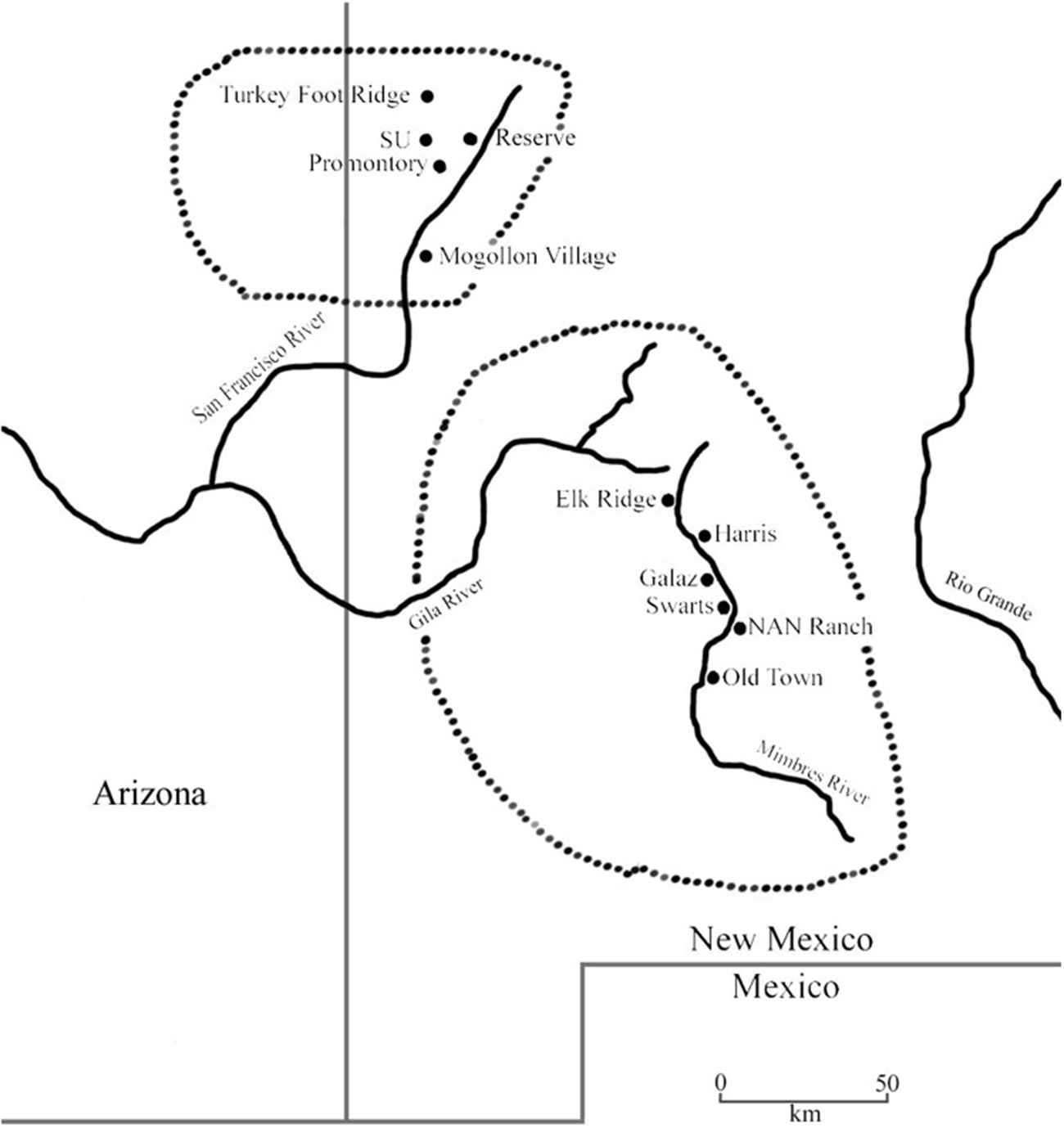
Evidence from Elk Ridge pueblo also points to social interaction with groups outside the Mimbres region. Interaction with Upland Mogollon (Reserve) groups to the north is evident in burials, ceramics, and architecture at the site (Roth et al. Reference Roth, Romero and Creel2022). The Upland Mogollon occupied areas of eastern Arizona and New Mexico north of the Mimbres region, primarily along the San Francisco and Tularosa Rivers and the surrounding region, approximately 100 km northwest of the Mimbres Valley across rugged terrain (Figure 5). The Mimbres Classic period generally aligns with the Reserve phase (AD 1000–1100). Reserve-area pueblo room blocks were often L-shaped and ranged from five to 40 rooms (Martin and Rinaldo Reference Martin and Rinaldo1950). Some pueblo walls were constructed with cobbles in adobe mortar, but outer walls were often built with shaped rocks and laminate slabs. Burials were usually flexed or semiflexed, and occipital head deformation was common. Burials often contained multiple vessels that were usually corrugated or plain bowls and jars; painted vessels were notably absent from burials. Smudging—blackened and often polished surfaces, usually on bowl interiors—is a ceramic hallmark of Upland Mogollon group identity (Stone Reference Stone2018).
Upland Mogollon and Mimbres areas (map by Danielle Romero).

The prevalence of smudged wares at Elk Ridge along with other ceramic and architectural traits suggest sustained interaction with Upland (Reserve) groups that we interpret was the result of intermarriage (Romero Reference Romero2024; Roth et al. Reference Roth, Romero and Creel2022). The inference of intermarriage is drawn from a burial in Room 113 at Elk Ridge and subsequent changes in material culture that appeared in later pueblo rooms. Room 113 was the middle of a series of three remodeled pueblo rooms (112, 113, 105). The burial was an adult male (35–45 years old) who was morphologically distinct from the other burials recovered at the site and who exhibited occipital head deformation. He was buried with a Reserve smudged bowl with a kill hole. The vessel is sourced to the Elk Ridge site, so it was made there (Romero Reference Romero2024).
Ceramic and architectural changes that we see as related to Reserve influence and interaction are evident in a subsequent series of rooms (101, 117, 118). Smudged and Reserve corrugated wares increased, with smudged wares accounting for 9% of the ceramic assemblage, which is significantly higher than the percentage found at other Classic period Mimbres pueblos (Romero Reference Romero2024). Painted wares with Upland motifs such as opposed designs and cloud terraces were found in these rooms. One burial from Room 101 had a bowl with a Reserve geometric design that is sourced to Elk Ridge, indicating that it was produced locally. All of the other smudged burial vessels from Rooms 101, 117, and 118 are sourced to Elk Ridge, which indicates that they, too, were made locally (Romero Reference Romero2024). Architectural data also point to Reserve influence associated with these series of rooms, visible in the construction of a well-made masonry outer wall in Rooms 117 and 118.
No smudged vessels have been recovered from the Ranger Station site, and only three smudged sherds were found, all from Room Block 3 (Nicolay and Roth Reference Nicolay and Roth2023). Reserve-style motifs are also very rare on vessels from the Ranger Station site. Two painted vessels from a looter collection display Reserve influence, and both are sourced to the Ranger Station site (Creel Reference Creel2022). The low frequency of Upland Mogollon influence at the Ranger Station site compared to Elk Ridge may indicate that interaction with upland groups was confined primarily to the main pueblo at Elk Ridge and did not include the entire local community.
Discussion: Reconstructing the Elk Ridge Community
Adler (Reference Adler, David and Wilson2002b:202) argues that the community represents a “durable transgenerational social group.” Our reconstruction of the Elk Ridge community indicates that it operated at several scales but that social connections were especially important, not just for the Elk Ridge community but for other communities throughout the Mimbres region and beyond. The overall nature of the Elk Ridge community is similar to other Neolithic farming communities in that it was influenced by the environmental setting, especially the distribution of arable land and water; social networks that formed via exchange, intermarriage, and population movement; and ritual practices that served to ensure community cooperation and cohesion.
At the site level, we see Elk Ridge pueblo as the center of the local Elk Ridge community. The pueblo occupation involved (1) families moving into and out of the room blocks and (2) intermarriage with groups from other large pueblos in the valley and to the north in the Upland Mogollon region. These interactions created kin ties and social relationships that were essential for success within this ecological and economic setting in the Mimbres Valley. Land tenure was an important aspect of village life from at least the Three Circle phase occupation and became more important as the pueblo grew. Intravillage community rituals in kivas and plazas helped maintain social cohesion and cooperation, and the social flexibility observed in aspects of architecture and resource access helped to ensure village success.
Given the environmental setting of the pueblo near the Three Forks confluence at the northern end of the Mimbres River Valley, we think that connections with the local community—represented by the Ranger Station pueblo and a series of other smaller pueblos located along the drainages—was essential to the community. These connections between sites are most clearly observed in ceramics, but we infer that they were socially based and therefore likely involved relationships that had to be established, negotiated, and maintained, often through community rituals. We see the need for cooperation in agricultural production as the major impetus for the establishment of the local Elk Ridge community, although ceramic production appears to have been another impetus for community connections. The many smaller (<5 rooms) pueblos along these drainages served as both field houses and land markers.
Finally, the Elk Ridge community participated in a broader community both within the Mimbres River Valley and beyond. This was likely fortified by exchange networks, but those exchange relationships led to social connections. The Elk Ridge community shared the Mimbres identity common to the other large pueblos in the valley (Gilman et al. Reference Gilman, Creel, Gruber, Roth, Gilman and Anyon2018; Hegmon et al. Reference Hegmon, Russell, Baller, Peeples and Striker2021), and yet their connections with the Upland Mogollon show that they were not limited to the valley proper.
The Elk Ridge community provides an example of factors that influence community development across space and time and that have implications for examining communities in other areas. Community development at Elk Ridge was heavily influenced by the environmental setting—most notably, the availability of arable land—and this structured how groups were distributed across the landscape and, in turn, how they interacted. In this sense, the community is similar to Hohokam communities in southern Arizona and many Neolithic communities in the Near East, where river systems provided opportunities and constraints on settlement distribution, connectivity, and interaction. Land tenure became important in these settings, leading to systems for granting and maintaining access that was reinforced socially and ritually through a variety of practices, including generational rebuilding and burial practices.
This study of the Elk Ridge community also illustrates the value of examining social interaction as underlying the concept of community (following Yaeger and Canuto Reference Yaeger, Canuto, Canuto and Yaeger2000). The Elk Ridge community exhibits a dynamic, flexible social strategy within a framework of extended family corporate group organization. Similar to what Adler (Reference Adler, Mark and Richard2002a:106) has described for the Mesa Verde region, we see the Elk Ridge community as being continually “defined and redefined” by social movement and interaction reinforced by ritual practices. Households within the community continually negotiated access to land and other resources, and communal rituals served to reinforce cooperation—a process that has been documented dating back to the Pithouse period in the Mimbres Valley (Roth and Romero Reference Roth and Romero2022).
Conclusions
Schachner (Reference Schachner, Mark and James2008:171) notes that the “community is an ever-changing, emergent property rather than an always present object to be discovered.” We see this in the Elk Ridge community, which was represented by dynamic social interaction from its inception. People moved in and out, exchanged goods with groups to the north and south, and used kinship ties, agricultural production, exchange, and ritual to signify and fortify community bonds. Evidence of strong connections between Upland Mogollon and Elk Ridge suggests complex networks of cultural interaction involving exchange and, likely, intermarriage. The Elk Ridge community illustrates the importance of landscape, exchange networks, ritual, and social relationships in community development and persistence.
Acknowledgments
We would like to thank the field-school students and volunteers who worked on UNLV’s excavations at Elk Ridge for their hard work and dedication. Special thanks to Grant County Archaeology Society volunteers Marilyn Markel, Josh Reeves, and Kyle Meredith, who helped during all four field seasons. We thank Darrell Creel for providing his data and insights, especially concerning the INAA analysis; Karl Laumbach for providing data on the occupation of the southern portion of Elk Ridge; and Bob Stokes for sharing his data and thoughts on community development in the Mimbres region. Thanks to Gabriella Oré Menéndez for translating the abstract. We greatly appreciate the very helpful comments from two anonymous reviewers.
Funding Statement
Funding for UNLV’s excavations at Elk Ridge was provided by a cost-share agreement between the Department of Anthropology at UNLV and the US Forest Service.
Data Availability Statement
Data used in this study are on file at the Department of Anthropology, UNLV. All artifacts and records from Elk Ridge will be curated at the Western New Mexico University Museum in Silver City, New Mexico, once all analyses are completed.
Competing Interests
The authors declare none.


 Open access