

1. Introduction
Researchers have used stable isotopes (δ18O or δD) in water to study lake balances (e.g. Reference Gat, Bowser and KendallGat and others, 1994; Reference GibsonGibson, 2002; Reference Tian, Yao and GongTian and others, 2005; Reference Gibson, Prowse and PetersGibson and others, 2006) and the hydrological cycle (e.g. Grafensteina and others, 1996; Reference Gibson, Prepas and McEachernGibson and others, 2002), and have shown that isotope compositions of lake water provide a sensitive indicator of climate change (Reference Wei and LinWei and Lin, 1995). Reference GonfiantiniGonfiantini (1986) established a lake-water isotopic equilibrium formula by studying stable-isotope fractionation in lake-water evaporation. Reference GibsonGibson (2002) discussed fraction/time-dependent models for the isotopic composition of lake water during different seasons in Arctic lakes. These studies demonstrate that δ18O can be used as an indicator of lake-water balance processes.
The Tibetan Plateau holds 1091 lakes larger than 1.0 km2, with a total area of almost 45000 km2 (Reference Lu, Yao, Wang, Liu and GuoLu and others, 2005). These provide an excellent opportunity to study the lake-water balance process using δ18O methods. Reference Tian, Liu, Gong, Yin, Yu and YaoTian and others (2008) pointed out that humidity and precipitation are two major factors controlling the isotopic composition of inland lake water. However, the isotopic balance process of lake water remains poorly understood on the Tibetan Plateau. For example, glacial meltwater feeds most of the lakes on the Tibetan Plateau and can contribute considerable amounts of water, but we know very little about how glacial meltwater influences δ18O in lake water. Glaciers and lakes might be coupled, but no detailed information exists about the interactions between glaciers and lakes on the Tibetan Plateau. Previous studies (Reference Dyurgerov and MeierDyurgerov and Meier, 2000; Reference Pu, Yao, Wang, Su and SengPu and others, 2004; Reference Yao, Wang, Liu, Pu, Shen and LuYao and others, 2004, Reference Yao, Pu, Lu, Wang and Yu2007; Reference Liu, Ding, Li, Shangguan and ZhangLiu and others, 2006) show that glaciers on the Tibetan Plateau are rapidly retreating. The retreating glaciers bring more glacial meltwater and more intensive influences on lake-water balance. A study focusing on isotopic variations from glacial melt-water to lake water in lake basins can help us to understand the mechanisms that affect lake-water balance processes. In order to study the interaction between glaciers and lakes based on the δ18O, we systematically collected water samples from two representative lake basins, Yamdrok-tso and Puma Yum-tso, located on the southern Tibetan Plateau.
2. Study Sites and Sampling Analysis
Yamdrok-tso (288270-298120N, 90°08 ′-91°45ʹE) is the largest closed lake basin on the southern Tibetan Plateau, with a lake-water area of 638 km2 (Reference GuanGuan and others, 1984) and a basin area of 6100 km2 (Fig. 1). The lake lies at an elevation of 4440 m and has a perimeter of -400 km (Reference LiuLiu, 1995). The annual average air temperature is 2.4°C, and the measured multi-year average temperature of surface lake water in the non-ice period is 10°C. The annual precipitation amount is ~400 mm, ~90% of which occurs in June-September. The lake contains -1.6 1010m3 of water, and the multi-year average evaporation is 8.25 x 10⁸m3 (Reference LiuLiu, 1995). The lake is generally 30-40m deep, with a maximum depth of 59m. The lake basin is composed of several small narrow lakes. Glacial meltwater contributes significant inflow. Rivers mostly enter at the west, south and southeast shores. The largest, the Kadongjia river, flows northward to the lake with an annual discharge of ~5m3 s–1 (Reference GuanGuan and others, 1984). The second largest, the Gamalin river, originates from Lugela mountain. The total glacier area in the lake basin is 94.4 km2. Qiangyong glacier is a major glacier providing meltwater to Yamdrok-tso lake. It covers an area of 7.98 km2, its terminus is at 4910 m and its annual equilibrium line lies at -5850 m (Reference GuanGuan and others, 1984). Meltwater from Qiangyong glacier feeds Yamdrok-tso lake through the Kaluxiong river (Reference Zhu, Wang and BranceljZhu and others, 2005), with an annual discharge of - 3 m3 s–1 (Reference GuanGuan and others, 1984). Qiangyong glacier is retreating as regional temperature increases (Reference Pu, Yao, Wang, Su and SengPu and others, 2004), which might bring more meltwater to Yamdrok-tso lake.
(a) Map of the Tibetan Plateau, with box locating the research area shown in detail in (b). (b) Map of the research area, showing Yamdrok-tso and Puma Yum-tso lake basins (shaded), and the water-sampling sites (numbered) in Yamdrok-tso lake basin. The dotted box delineates Puma Yum-tso lake basin, shown in more detail in (c). (c) Map of Puma Yum-tso lake basin showing water-sampling sites (numbered). In (b) and (c) the solid triangles indicate locations of deep lake-water samples, the solid circles show sampling sites of surface lake water, the open squares indicate sampling sites of glacial meltwater and the numbers represent sequence number of samples.
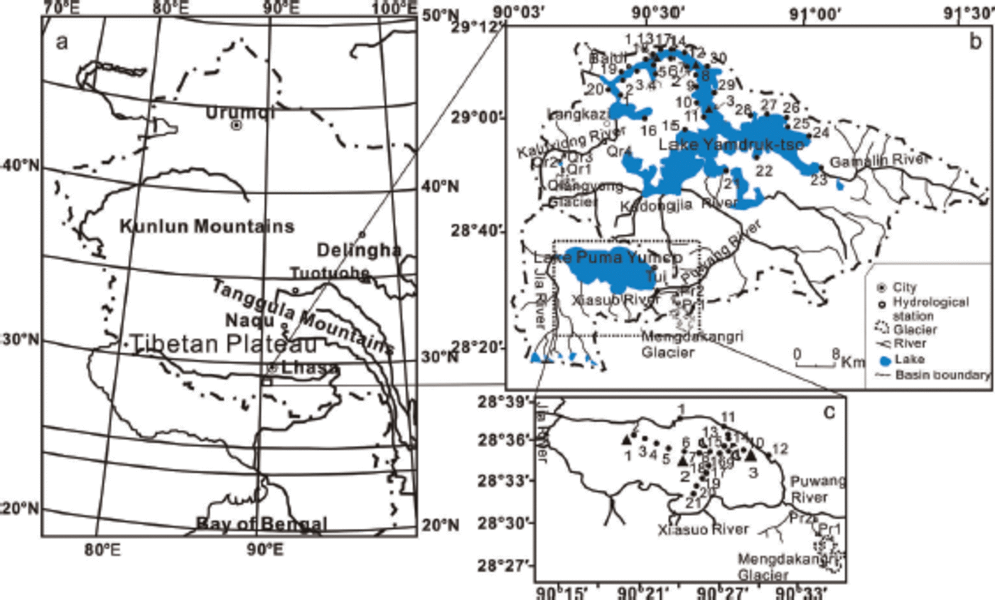
Puma Yum-tso lake (288290–288380 N, 908130–908330 E) lies southwest of Yamdrok-tso lake and has a tectonic origin (Reference ZhangZhang, 1982). It covers 284 km2 (Reference GuanGuan and others, 1984) (Fig. 1) at an elevation of 5030 m, and the basin area is ~1233 km2 (Reference JuJu and others, 2012). The lake depth reaches 60 m but is generally 30-50 m. The annual air temperature is 2-4°C (Reference Wang and DouWang and Dou, 1998), and the measured multi-year average temperature of lake surface water in the non-ice period is 7.5°C. The annual precipitation amount is ~350 mm. The lake contains ~8.93 x 10⁹m3 of water, and the multi-year average evaporation is ~2.88x10⁸m3. Alluvial plain approaches primarily from the west, south and east shores, while the north shore abuts mountains (Reference Wang and DouWang and Dou, 1998). Because Puma Yum-tso lake basin sits higher than Yamdrok-tso lake basin, glacial meltwater is significant for maintaining steady lake-water levels (Reference ZhuZhu and others, 2006). The largest river flowing into Puma Yum-tso lake is the Jia river, which is replenished by glacial meltwater. The discharge of the Jia river reached 7.6 x 10⁵ m3 d–1 in August 2005, accounting for 77% of total inflow into the lake (Reference JuJu and others, 2012). The Xiasuo river is another major inflow, flowing northward into the lake. The total glacier area in the lake basin is 135.1 km2. Mengdakangri glacier lies southeast of Puma Yum-tso lake and extends ~3.1 km with a total elevation change of -900 m (Fig. 1), covering ~2.45 km2. Its meltwater flows into the Puwang river.
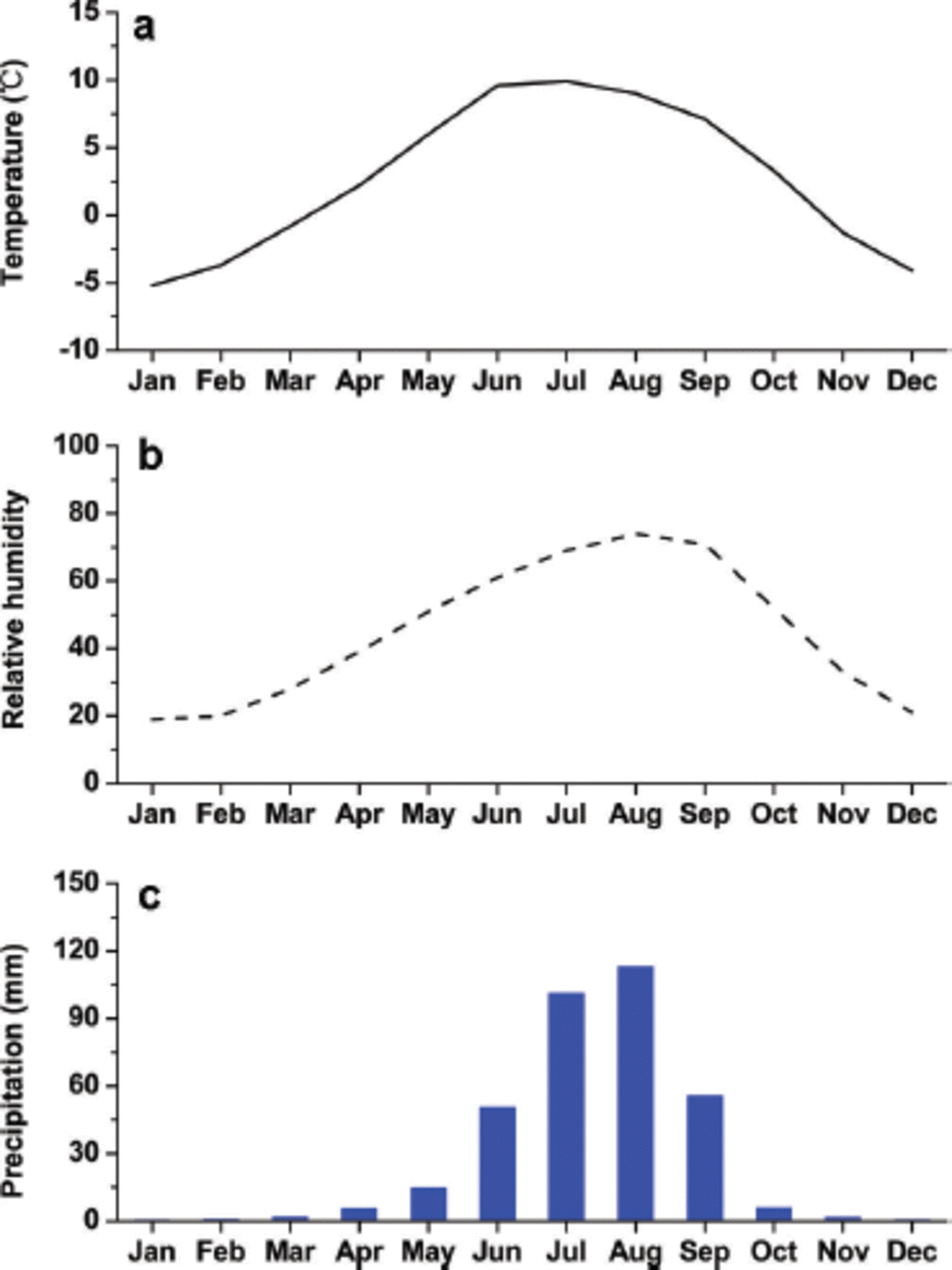
Langkazi meteorological station at Yamdrok-tso lake records a mean annual temperature of 2.6°C, long-term average annual rainfall of -350mm (Fig. 2) and a mean annual evaporation of -1330 mm (Reference Tian, Liu, Gong, Yin, Yu and YaoTian, 2008). The predominant southwest monsoon is the main climatic feature of the region. About 90% of all precipitation occurs between April and September, with monthly precipitation reaching a maximum in August (Reference LiuLiu, 1995). Puma Yum-tso lake, located south of and higher than Yamdrok-tso lake, lies near the upland maximum precipitation zone. Consequently, it experiences lower temperatures, more precipitation and less evaporation than Yamdrok-tso lake. Both lakes are generally ice-covered in winter.
Variations of monthly average air temperature (a), relative humidity (b) and precipitation amount (c) at Langkazi meteorological station in 2006–07.
Our fieldwork in August 2006 yielded water samples at different sites in the two lake basins. Samples from Yamdrok-tso lake basin were collected starting from the terminus of Qiangyong glacier, along the Kaluxiong river and ending in Yamdrok-tso lake (Fig. 1b). We also collected samples in two depth profiles (both 35 m) in Yamdrok-tso lake. Similar sampling was accomplished in Puma Yum-tso lake basin. Samples were collected from the terminus of Mengdakangri glacier to Puma Yum-tso lake. Two depth profiles (53 and 30 m) were collected, the deeper profile near the center of the lake, and the other profile -14km away. We collected 67 samples in Yamdrok-tso lake basin and 48 in Puma Yum-tso lake basin. We chose six locations for individual glacial meltwater sampling: four sites (Qr1, Qr2, Qr3 and Qr4) in Yamdrok-tso lake basin and two (Pr1 and Pr2) in Puma Yum-tso lake basin (Fig. 1b). We resampled similar locations in July 2007 and sampled two new depth profiles (45 and 40 m) in both lakes. In addition, event-based precipitation samples were collected at Baidi hydrological station from February to September 2007, and Dui hydrological station from March to October 2007. Surface lake water was also sampled every 7 days at Baidi and Dui from January to December 2007.
Collected samples were sealed in 20 mL polyethylene bottles and transported to the Key Laboratory of Tibetan Environment and Land Surface Processes, Chinese Academy of Sciences, for analysis. δ18O was measured with a MAT-253 mass spectrometer (precision 0.1 %), based on isotopic equilibrium exchange between oxygen of CO2 and H2O. All data are presented relative to the VSMOW (Vienna Standard Mean Ocean Water; NIST, 1992).
3. Modelling Description of Isotopic Variation for the Two Lakes
Reference GibsonGibson (2002) has provided a simple model of water balance process for a closed basin. Reference Tian, Liu, Gong, Yin, Yu and YaoTian and others (2008) studied the importance of precipitation and relative humidity for Yamdrok-tso lake using a modified version of this model. The model is suitable for describing the changes in δ18O occurring in summer due to evaporation when glacial meltwater and precipitation provide the lake’s main input.
The water and isotope mass balance for a closed lake during its ice-free period may be written as follows (Reference GibsonGibson, 2002; Reference Tian, Liu, Gong, Yin, Yu and YaoTian, and others, 2008), assuming that evaporation consumes total precipitation and river inflows:
where V is the volume of the lake, t is the time, dV is the change in volume over time interval dt, I is the total inflow where I=I S +P ( I S is the surface inflow and P is the precipitation on the lake surface), E is the evaporation and δL, δI, δE are the isotopic compositions of the lake, inflow and evaporation flux, respectively.
Lake evaporation is mainly affected by temperature, wind speed and relative humidity. Reference Craig, Gordon and TongiorgiCraig and Gordon (1966) have described the isotopic composition of the evaporation flux:
where a* is the equilibrium liquid-vapor isotope fractionation, h is the ambient atmospheric relative humidity, e is the total isotopic separation factor, and = ε* + εK (ε* is the equilibrium coefficient and εK is the kinetic coefficient). Temperature controls ε*, whereas εK is mainly impacted by the turbulent/diffusion mass transfer mechanisms and humidity. ![]() is the isotopic composition of the atmospheric moisture and can be represented by
is the isotopic composition of the atmospheric moisture and can be represented by ![]() (δP is the isotopic composition of precipitation; Reference Tian, Liu, Gong, Yin, Yu and YaoTian and others, 2008). In this region, both precipitation and evaporation mainly occur in summer, so
(δP is the isotopic composition of precipitation; Reference Tian, Liu, Gong, Yin, Yu and YaoTian and others, 2008). In this region, both precipitation and evaporation mainly occur in summer, so ![]() represents a more summer complexion.
represents a more summer complexion.
In these closed lakes, we assume that lake volumes are steady ![]() and
and ![]() The change in isotopic composition of the lake water with time t can be defined as (Reference GibsonGibson, 2002)
The change in isotopic composition of the lake water with time t can be defined as (Reference GibsonGibson, 2002)
where ![]() defined by Reference Welhan and FritzWelhan and Fritz (1977) and Reference Allison and LeaneyAllison and Leaney (1982), and
defined by Reference Welhan and FritzWelhan and Fritz (1977) and Reference Allison and LeaneyAllison and Leaney (1982), and ![]() is the steady-state isotopic composition. δ0 is the initial isotopic composition of the lake water
is the steady-state isotopic composition. δ0 is the initial isotopic composition of the lake water ![]() is defined as the limiting isotopic composition under local meteorological conditions (Reference Gat and LevyGat and Levy, 1978; Reference GatGat, 1981). Finally, the isotopic composition of the lake water will reach a constant value with repeated successive steps of lake-water evaporation and inflow replenishment.
is defined as the limiting isotopic composition under local meteorological conditions (Reference Gat and LevyGat and Levy, 1978; Reference GatGat, 1981). Finally, the isotopic composition of the lake water will reach a constant value with repeated successive steps of lake-water evaporation and inflow replenishment.
4. Results and Discussion
4.1. Temporal variations of δ18O in waters in the two lakes
4.1.1. Temporal variations of δ18O in precipitation
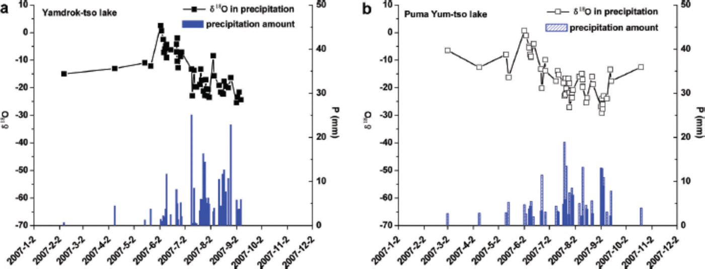
Figure 3 shows the temporal variations of δ18O in precipitation and the corresponding precipitation amount in Yamdruk-tso and Puma Yum-tso lakes in 2007. The range of δ18O in precipitation is -27.13% to -2.39% in Yamdruk-tso lake, and -29.16% to 0.69% in Puma Yum-tso lake. The highest δ18O in precipitation occurs in spring, coinciding with low precipitation amount. When precipitation increases in summer, the δ18O decreases. A clear ‘amount effect’ is seen, with a correlation coefficient of 0.31 (p<0.05) at Yamdrok-tso lake and 0.50 (p<0.01) at Puma Yum-tso lake, indicating the southwest monsoon dominates the temporal variations of δ18O in precipitation in both lake basins. The coincident seasonal variations of δ18O in precipitation in the two lake basins imply the influence of similar large-scale moisture transport. In winter, storms result in low δ18O in precipitation. Compared with Yamdrok-tso lake, Puma Yum-tso lake has a precipitation amount ~10 mm higher and an average δ18O in precipitation ~2.72% lower in 2007, due to higher elevation. The lapse rate of δ18O in precipitation is ~–0.4% (100 m)–1 for both lake basins, which is within the range of values previously reported in the TP (-0.12%(100 m)–1 to -0.4%(100m)-1 (Reference Hou, Masson-Delmotte, Qin and JouzelHou and others, 2003; Reference Li, Yao, Tian, Yu, Guo and WangLi and others, 2006)). Compared with the δ18O results in 2004 (Reference Tian, Liu, Gong, Yin, Yu and YaoTian and others, 2008), a similar seasonal pattern of precipitation δ18O is shown in 2007 for both lake basins. The weight mean precipitation δ18O changes <1% at Baidi and Dui stations in these two years, indicating that the isotopic signature of precipitation is coherent.
The temporal variations of precipitation δ18O and concurrent precipitation amount at (a) Baidi hydrological station in 2007 and (b) Dui hydrological station in 2007. Dates are year-month-day.
4.1.2. Temporal variations of δ18O in surface lake water
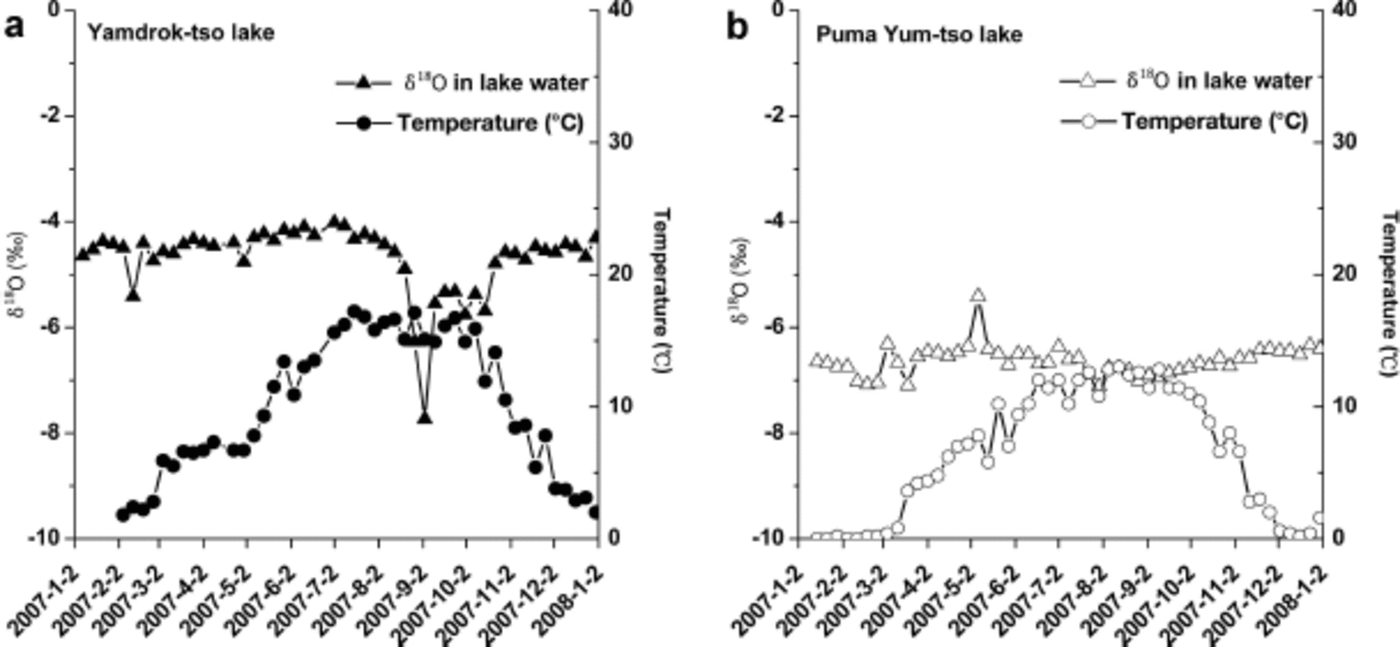
Figure 4 shows the temporal variations of δ18O in surface lake water and the concurrent temperature of surface lake water in 2007. In both lakes, the δ18O in surface lake water decreases significantly in July and reaches a minimum in August and September, but keeps steady in other months. The seasonal variation in 2007 is similar to that shown in 2004 (Reference Tian, Liu, Gong, Yin, Yu and YaoTian and others, 2008), suggesting a constant isotopic pattern of lake water in both lakes. Monsoon precipitation and glacial meltwater, with lower δ18O values which markedly increase in summer, are likely responsible for seasonal variations of δ18O in surface lake water. The variation of δ18O in surface lake water does not coincide with that of the surface lake-water temperature in both lakes. The elevation increased by ~590m while the mean temperature of surface lake water decreased by 3.58°C in 2007. The average surface lake-water δ18O is -6.63% in Puma Yum-tso lake, and -4.69% in Yamdrok-tso lake. The difference (1.94%) is smaller than the calculated difference of precipitation δ18O (2.36%) based on the lapse rate of precipitation δ18O in both lake basins. This may indicate the weaker influence of precipitation on lake water and the potential influence of evaporation. In addition, the weaker variation of surface lake-water δ18O in Puma Yum-tso lake (<2%) than in Yamdrok-tso lake indicates a stable supply that is weakly influenced by monsoon precipitation in different seasons. The influence of glacier meltwater is more significant than that of summer precipitation for Puma Yum-tso lake, as shown by stable isotopes of lake water in Figure 4. The flow rate of the Jia river close to the estuary, the largest source of runoff for Puma Yum-tso lake, is 761 000 m3d–1 in summer 2005, 77% of the whole supply (Reference JuJu and others, 2012). The much larger supply of river water results in less depletion of lake-water δ18O in summer, compared with Yamdrok-tso lake, and makes the influence of monsoon precipitation on the lake-water δ18O unnoticeable in PumaYum-tso lake. In contrast to δ18O in precipitation, δ18O in surface lake water is much higher (13-18%) due to intense evaporation. The variation of δ18O in precipitation at Baidi station is marginal between 2004 and 2007, but lake-water δ18O in Yamdrok-tso lake increased by 1.4% due to increased δ18O in river water (~1%) and intense evaporation. The δ18O in precipitation decreased ~1% between 2004 and 2007 in Puma Yum-tso lake, but the lake-water δ18O shows a slight enrichment in 2007. Thus, we suggest that monsoon precipitation cannot be the dominant factor controlling variation of lake-water δ18O in both lakes at interannual timescale.
The temporal variations of lake-water δ18O and concurrent surface lake-water temperature at Baidi hydrological station (a) and Dui hydrological station (b) from January 2007 to January 2008 (b). Dates are year-month-day.
4.2. Spatial variations of δ18O in water from the two lakes
4.2.1. δ18O changes from the glacial termini to Yamdruk-tso and Puma Yum-tso lakes
Figure 5a and b show the detailed spatial variations of δ18O in water for the two lake basins. Higher elevation is correlated with lower δ18O (Fig. 5a and b). Thus, δ18O increased from -18.9% at the terminus (4960ma.s.l.) of Qiangyong glacier, with the highest peak at 6324 m a.s.l., to -5.4% in the center of Yamdrok-tso lake (4440 m a.s.l.). We obtained a δ18O lapse rate of ~–0.19%(100m)-1 in the north of Yamdrok-tso lake (from the terminus of Qiangyong glacier to the estuary of the Kaluxiong river).
Variations of δ18O from glacial termini to lakes in August 2006: (a) δ18O of glacial meltwater from Qiangyong glacier starting at the glacial terminus and ending in Yamdrok-tso lake; (b) δ18O of glacial meltwater starting at the glacial terminus and ending in Puma Yum-tso lake; and (c) a comparison of average δ18O values from glacial termini to lakes in the two lake basins.
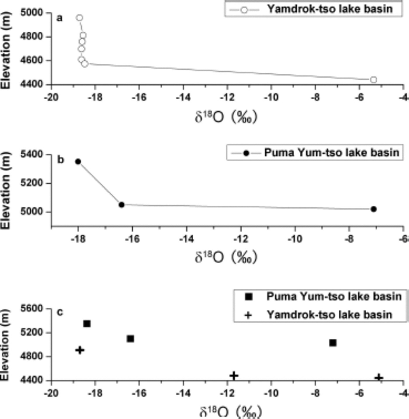
As shown in Figure 5b, δ18O values also change from glacial meltwater to lake water in Puma Yum-tso lake. They increase from -18.0% at the terminus of Mengdakangri glacier (5352 m a.s.l.), with the highest peak at 6422 m a.s.l., to -7.1 % in the center of Puma Yum-tso lake (5020 m a.s.l.). The decrease in elevation is the fundamental cause of the change in δ18O, due to the resulting temperature increases and evaporation intensification in the lakes compared to the glacial terminus.
Figure 5c shows the averaged δ18O over larger areas for the two lake basins. The average δ18O values clearly indicate the role of evaporation: there is more evaporation at Yamdrok-tso lake (4440 m a.s.l.), which is 590 m lower than Puma Yum-tso lake (5030 m a.s.l.).
4.2.2. δ18O changes in surface water
Figure 6a and b show the detailed spatial variations of δ18O from the shoreline at river outflow to the center of Yundrok-tso lake in August 2006 and July 2007. The surface lake-water samples show a wide range of δ18O changes, and the average δ18O enriched by 1.20% between 2006 and 2007. We define the influx of the Kaluxiong river (Fig. 6a) and the Gamalin river (Fig. 6b) as the starting points of sampling. In both years, δ18O clearly increases with distance from the river estuary to the lake center, reflecting the gradual mixing behavior between glacial meltwater and lake water. We document distance effects of 0.88% (100 m)–1 from the influx of the Kaluxiong river to the lake center and 1.49% (100 m)–1 from the influx of the Gamalin river to the lake center. Because more river discharge enters the west lake, distance effects appear to increase from west to east.
(a) δ18O of surface water versus distance northeastward from the influx of the Kaluxiong river (increasing distance from the influx of glacial meltwater) in Yamdrok-tso lake in August 2006 and July 2007. (b) δ18O of surface water versus distance northwestward from the influx of the Gamalin river (increasing distance from the influx of glacial meltwater) in Yamdrok-tso lake in August 2006 and July 2007. (c) δ18O of surface water versus distance from the influx of the Xiasuo river northward to the north shore of Puma Yum-tso lake in August 2006 and July 2007. (d) δ18O of surface water versus distance eastward from the influx of the Jia river to the east shore of Puma Yum-tso lake in August 2006 and July 2007.
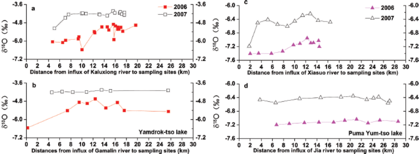
In Puma Yum-tso lake, we define the estuaries of the Jia and Xiasuo rivers as the starting points of sampling. From the south to the north of the lake, δ18O in the surface lake water increases by ~0.5% in August 2006 and 0.9% in July 2007 (Fig. 6c). It also increases from the influx of the Jia river to the lake center (Fig. 6d). Due to the longer distance from the Jia river on the west to the east of the lake, dδ18O increases more slowly. The rates of surface isotopic increase in Puma Yum-tso lake are 0.29%(100m)-1 from south to north and 0.11%(100m)–1 from west to east, much smaller than in Yamdrok-tso lake. The lower rates of surface isotopic increase in Puma Yum-tso lake are due to its higher elevation which results in less evaporation.
Similar characteristics of δ18O variation from the estuaries to the lake center are identified for both lakes. This indicates the gradual mixing between inflow river water and lake water. The lapse rate is affected by the distance to the estuaries.
4.2.3. δ18O changes with depth
Depth profiles of the two lakes reflect their similar circulation patterns (Fig. 7). Both lakes exhibit inconspicuous stratification and obvious isotopic enrichment during the observation period. δ18O values of the 35 m depth profiles increase by ~1% between August 2006 and July 2007. The 35 m deep Yamdrok-tso lake has dδ18O values enriched by 0.6% in August 2006, followed by lower heavy-isotope enrichment of 0.4% by July 2007. Similar δ18O enrichments of depth profiles are found in Puma Yum-tso lake, where δ18O values enriched by ~0.6% between August 2006 and July 2007. The 55 m depth profile shows a clear increasing trend of δ18O in August 2006, but this disappears in July 2007. This indicates that large amounts of fresh water with lower δ18O (meltwater and precipitation) flow into lakes in summer, resulting in lower δ18O in the upper layer, as well as the unimportant effect of seasonal lake-water dynamics (<0.6%) for both lakes.
(a, b) Depth profiles of δ18O for Yamdrok-tso lake on 27–31 August 2006 (a) and 10–13 July 2007 (b). (c, d) dδ18O variations of depth profiles for Puma Yum-tso lake on 20–25 August 2006 (c) and 6–7 July 2007 (d).

4.3. Quantitative estimates of the influence of different factors on dδ18O
Previous studies have demonstrated that relative humidity is an important control on the evaporation process in the two lakes (Reference Tian, Liu, Gong, Yin, Yu and YaoTian and others, 2008). Our model results focus on the influence of glacial meltwater and surface lake-water temperature on dδ18O variations of lake water.
For Yamdrok-tso lake, the initial lake-water δ18O (60) is assumed to equate to the δ18O value of glacial meltwater (-18.3%) from Qiangyong glacier. The inflow δ18O is assumed to vary from -18.9% to -17.6% based on observations of the Kaluxiong river in 2007. The SP, the δ18O in precipitation, is -16.6% calculated as the weighted mean precipitation at Baidi station in 2007. The surface lake-water temperature is 10°C. For Puma Yum-tso lake, we assumed 0 is -18.4%, P is -18.1% and the weighted mean precipitation at Dui station and the δ18O of inflow changes from -17.8% to -19.0% based on the glacial meltwater of Mengdakangri glacier in 2007. The surface lake-water temperature is 7.5°C. We simulate the evolution of lake-water δ18O under different conditions using the model mentioned above.
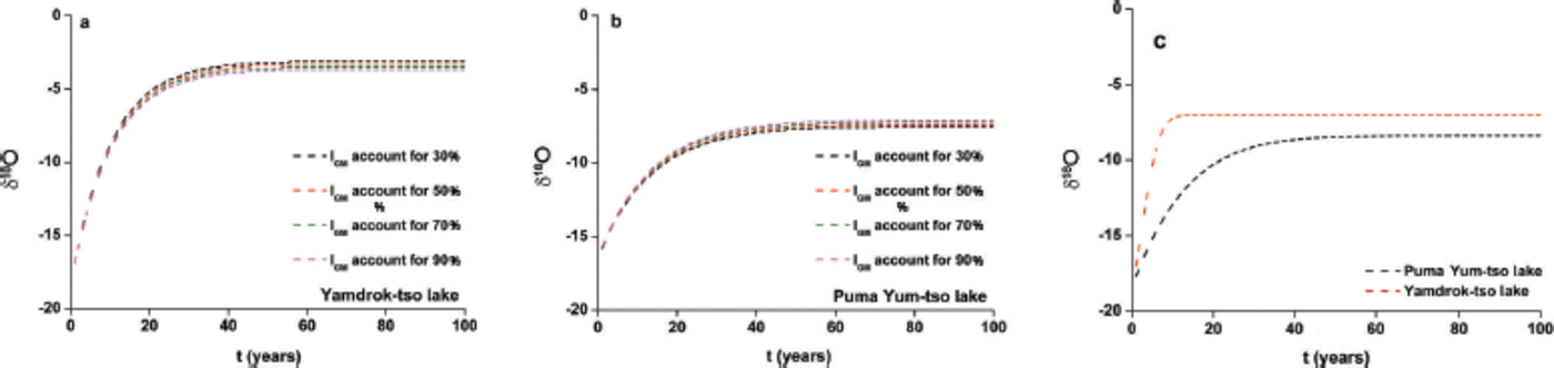
To evaluate the influence of possible enhanced glacial meltwater on the lake-water isotope variation in the future, we modeled the lake-water δ18O changes by assuming different percentages of glacial meltwater (30-90%) input under present climate conditions. Figure 8 shows the influences of glacial meltwater on equilibrium processes of δ18O in the two lake basins. During the first 40 years, δ18O values increase rapidly for both lakes and then approach equilibrium values. The lakes then require a much longer time to achieve the final equilibrium δ18O values. Equilibrium δ18O values decreased 0.8% for Yamdrok-tso lake and 0.6% for Puma Yum-tso lake when contributions of glacial meltwater to the two lakes shrank by 60% (Fig. 8a and b). The influence of precipitation is more marked for Yamdrok-tso lake (~80%) than for Puma Yum-tso lake based on observations. The influence of precipitation with lower δ18O strengthens correspondingly when a reduced supply of glacial meltwater with lower dδ18O values reaches lakes, resulting in a more marked change in equilibrium dδ18O value. In addition, the dδ18O increase for Yamdrok-tso lake is significantly faster than for Puma Yum-tso lake, and less time is needed to reach an equilibrium condition for Yamdrok-tso lake. Considering the observed decreases of lake-water volumes (0.21 Gta–1 for Yamdrok-tso lake and 0.0016Gta–1 for Puma Yum-tso lake (Reference Zhang, Yao, Xie, Kang and LeiZhang and others, 2013)), the lake-water dδ18O for Yamdrok-tso lake enriches -1%a–1 in the first 10 years and only takes one-third of the time taken by Puma Yum-tso lake to reach equilibrium δ18O values (Fig. 8c). The more intensive evaporation and lower contribution of meltwater for Yamdrok-tso lake causes the lake-water δ18O to enrich faster and require less time to reach an equilibrium condition because the altitude is ~600 m lower than at Puma Yum-tso lake.
(a, b) The modeled δ18O evolution of lake water in Yamdrok-tso lake (a) and Puma Yum-tso lake (b) as the model attributes different percentages of total inflow to glacial meltwater. (c) The modeled δ18O evolution of lake water in Yamdrok-tso and Puma Yum-tso lakes, considering the changes in lake-water volumes.
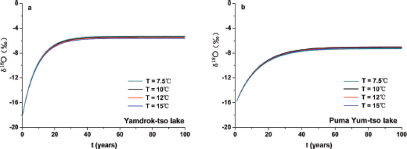
Compared with the influence of glacial meltwater, the modeled results show that the lake-water δ18O changes slightly with an increase in temperature of surface lake water (Fig. 9). The temperature increases by 5°C, while the steady lake-water δ18O changes by 0.23% for Yamdrok-tso lake and 0.17% for Puma Yum-tso lake. This indicates that the temperature of surface lake water is not a dominant factor in the lake-water δ18O changes. This is validated by the surface lake-water data analyzed above in both lakes.
The simulated δ18O values in lake water over time for Yamdrok-tso lake (a) and Puma Yum-tso lake (b) with different temperatures of surface lake water.
5. Conclusions
This study shows the seasonality and annual variations of lake-water dδ18O in two high-elevation lakes in the southern Tibetan Plateau. Because lower altitude results in more intensive evaporation and less contribution of meltwater to supply δ18O values are ~2% higher in Yamdrok-tso lake than in Puma Yum-tso lake. The combined study of sample analysis and model results, and a comparative study of lakes at two different elevations demonstrate that glacial meltwater and surface lake-water temperature are not the dominant controls in regulating isotope values of lake waters, although a more noticeable influence of meltwater is identified in Puma Yum-tso lake.
Modeling results show that δ18O increases rapidly during the initial stages and then approaches the equilibrium value after a longer time. δ18O values increase faster for Yamdrok-tso lake than for Puma Yum-tso lake. In addition, the surface lake-water temperature has a minimal impact on the equilibrium lake-water dδ18O. Air temperature is a dominant factor for evaporation and glacial melt, implying an indirect effect on lake-water dδ18O. Further studies are needed to confirm the influence of air temperature on lake-water dδ18O. The non-equilibrium condition between inflow and evaporation also needs to be complemented in the model.
Acknowledgements
This work was funded by the National Natural Science Foundation of China (grants 41101061 and 41190080), the ‘Strategic Priority Research Program (B)’ of the Chinese Academy of Sciences (CAS), grant No. XDB03030100, and the open research foundation of State Key Laboratory of Cryospheric Sciences, Cold and Arid Regions Environment and Engineering Research Institute, CAS. We also thank the staff at Tibet observation stations for collecting the precipitation samples and taking simultaneous notes, and the staff for measuring the samples.


