

Introduction
Globally, modern livestock farming practices are understood to be a major cause of the triple health, environmental, and climate crisis.Footnote 1 In the UK, there is a growing policy and public discourse focused on arresting and reversing the crisis. The UK’s Climate Change Committee (CCC) and the government-commissioned National Food Strategy (NFS) review both prioritise significant reductions in the production and consumption of red meat and dairy products to improve population health, encourage nature recovery, and meet the government’s statutory commitment to achieve ‘net zero’ by 2050.Footnote 2
Policy direction is reflected in wider society, with a long-term trend for decreasing meat consumption, which a limited body of evidence suggests is driven by concerns about the impact of meat production/consumption on climate, environment, and human health.Footnote 3 Analysis of UK trends in consumption of meat using National Diet and Nutrition Survey data for the years 2008/9 to 2018/19 shows an 11% reduction in people consuming red meat over the period and a 3% increase in people self-identifying as vegan or vegetarian, with 2018/19 recording a 5% increase.Footnote 4 Some public institutions such as universities and local councils are implementing plant-only food policies.Footnote 5 The direction of policy and indications of changing consumer demand presents a challenge for England’s grassland farming regions, such as the South-West of England (SWE), which altogether account for 56% of England’s farmed landFootnote 6 and where dairy farming and the rearing of cattle and sheep for meat are the principal farming activities. Clearly, there are climatic, topographical, and edaphic reasons why grassland is well suited to these areas and the growing of other human-edible crops is less feasible. However, natural limits provide only part of the story of what is a feasible farming activity in any particular location. What is produced is also a function of market demand, historical and contemporary policy drivers, and cultural and social factors within farming communities. Thus, the assertion that cattle and sheep farming is the only place-appropriate food production activity in areas where grassland is so important has to be seen in this wider context. That it is a consistent strand of farming and a wider public narrative is undeniable, characterised by the NFS as a ‘common refrain’,Footnote 7 which others suggest is ‘employed by proponents of maintaining or expanding livestock numbers […] often uncritically adopted by various sources’.Footnote 8
In its 2021 report, Facts about British red meat and milk, the NFU set out to correct what it refers to as ‘major myths’ about red meat and milk production in the UK.Footnote 9 The report seeks to counter the myth that ‘The land British livestock graze could be used to grow crops instead’Footnote 10 by stating:
Around 65% of farmland in the UK is best suited to growing grass rather than other crops. If we did not graze livestock on it, we could not use it to produce food.Footnote 11
The 65% statistic is extrapolated from DEFRA’s farming statistics on UK agricultural land use and refers to the percentage of the UK’s total utilised agricultural area, which is classified as common (rough) or permanent grassland.Footnote 12 The NFU’s unequivocal statement that the land could not produce human-edible food were it is not grazed by livestock glosses over a more nuanced reading of the statistics in three respects. First, while it is the case that some of the land will be unsuitable for any agricultural crop other than grass, some of the permanent grasslands (being grassland that has not been cultivated in the past 5 years), which makes up over half of the total grassland area, may be suitable for growing human edible crops. Second, the DEFRA June Survey figures cannot necessarily be relied upon to give a good indication of annual production in the regions, as they only capture crops in the ground on June 1.Footnote 13 This fails to account, for example, for winter brassica production in the SWE. Comparison with the Basic Payment scheme dataset suggests horticultural acreages nationally are underreported by some 39% within the June Survey.Footnote 14 Yet, the June Survey dataset can be used uncritically by policymakers; the National Food Strategy, for example, relies on the June Survey data to identity unproductive land with potential for rewilding, unwittingly including much of Cornwall’s winter brassica production area.Footnote 15 Third, it is also worth noting that DEFRA’s data refer to ‘land use’, which is not necessarily equivalent to productive capability of land, the former being essentially a management decision made by the farmer against a range of factors from the farmers’ own skills, preferences, and machinery, to consideration of access to and demand from markets, as well as topographic and edaphic conditions. For example, on the second page of Bella Bathurst’s acclaimed account of contemporary life on the land, Field Work, the author writes that the 180 acre Welsh farm that features in the book is ‘at 800 metres above sea level … too steep for growing arable crops’. However, a couple of pages later she refers to wheat requisitions in the 1914–1918 war and the cultivation of potatoes and sugar beet in the 1939–1945 conflict before turning to the farm post-war: ‘in 1950, 18 acres were cultivated for mixed corn or barley, half an acre for potatoes and 9 acres for mangolds and swedes’.Footnote 16
The tendency for those in farming to lean in on a simplistic and generalised characterisation of grassland being only good for growing grass, was reflected in our interviews with south-west farmers, as illustrated by the following extract:
…I was at a supper the other day and I had to remind everyone around the table you can’t eat grass. You know, physically we can’t eat grass and we might not be able to grow much else but grass … there is only so much we can do with it, yeah, we can plant it all to trees but that’s not necessarily going to solve the problem either. SWE Farmer
Moreover, this discourse has found some backing in the scientific literature. For example, crop scientists modelled the prospects for converting permanent grassland to winter wheat in the context of projected climate change impacts on the workability and trafficability of soil.Footnote 17 They conclude that there is a low probability of successfully cultivating winter wheat on converted grassland in SWE, ignoring a range of other arable crops that might fare better.Footnote 18 Thus, a strong narrative, which we refer to as the traditionality of grasslands (TOG) narrative, has emerged and has become important in the way arguments are deployed around future land use, particularly in the context of responding to climate change and the need for net zero farming.Footnote 19
Research approach
We draw on a range of secondary and primary research methods to interrogate the TOG narrative in three ways. First, we look at the evidence of previous land use patterns showing, in particular, the higher incidence of arable cropping in so-called grassland areas in periods of both the nineteenth and twentieth centuries. We use official and contemporary agricultural statistics and data from a 2020 postal survey of farmers in SWE (n = 1,117)Footnote 20 and semi-structured interviews with a total of 64 farmers and/or growers in SWE, conducted as part of two doctoral research studies, one investigating the drivers of change to fruit and vegetable production in Devon and Cornwall (not yet published), and the other investigating ruminant livestock farmers’ engagement with nonfarming people in the SWE in the context of the predominantly critical public discourse around red meat production.Footnote 21 We use the definition of the SWE as described by the South West Farm Survey as Cornwall, Isle of Scilly, Devon, Somerset, Dorset, Gloucestershire and Wiltshire.Footnote 22 Interviewees were recruited through a combination of purposive and snowball sampling techniques.Footnote 23 Following initial contact, participants were sent a Participant Information Sheet and Consent Form. Interviews were conducted only after receiving a signed Consent Form. All interviews were completed, transcribed, participant verified, and were analysed using inductive thematic analysisFootnote 24 in Nvivo, a qualitative data coding software package. The majority of interviews (n = 57) were located in Devon and Cornwall, which together account for 43% of farmed land in the regionFootnote 25 with the remaining 7 interviewees located in other counties of the region.
Second, we look at the contents of two government-sponsored agricultural publications; the nationally distributed journal Agriculture for the years 1950 to its final issue in 1972, followed by an examination of the regional series of pamphlets, Focus: Devon, published by the Agricultural Development and Advisory Service (ADAS) from its inception in 1971 to 1992. Agriculture was published by the Ministry of Agriculture (MAFF) in the 1920s. In the post-war period, it was aimed primarily at the farm advisory network which was so strong during those years, through the extensive reach of the National Agricultural Advisory Service (NAAS) established in 1946, and after 1971 its successor ADAS until the reduction of its budget in the 1980s and eventual privatisation.Footnote 26 The contents of both publications therefore provide a strong indication of perceived farming possibilities and priorities, nationally and specifically in relation to the SWE, during an important period of agricultural change. From our analysis and synthesis of these data, we argue that the TOG narrative has developed in the context of an unhelpfully narrow conception of the alternatives to grassland, primarily wheat, ignoring the wide range of horticultural and field crops that might provide an alternative to pasture dominated agriculture and which may be better suited to fitting into a mixed farming system incorporating a diversity of human edible plant and animal-sourced foods. Linked to this is the equally wide range of growing conditions not only within a region, a county, or a parish but even within a single farm. In the post-war period, technological innovations linked to an emergent productivist paradigm, which might be characterised as ‘get big and specialise or get out’ approach, dominated agricultural science research and extensionFootnote 27 and the supermarketisation of the food supply chain,Footnote 28 have both served to reinforce the TOG narrative. Thus, policy, market, and socio-economic (mutable) drivers strongly influence farmers’ decisions on land use, perhaps more than the (less mutable) actual productive capability of the land.
The Ebbs and flows of Arable cropping over time
In this section, we concentrate on data derived from the Agricultural Census for Great Britain which started in 1866. Completion was on a voluntary basis until it became mandatory for all farmers with the passing of the Corn Production Act in 1917. Voluntary completion was reintroduced in 1921, but completion of returns became mandatory again under the Agricultural Returns Act 1925. In the early years, local enumerators were appointed who did their utmost to ensure a near-census coverage by visiting farmers to persuade them to submit returns, helping them complete returns, and even making estimates in the relatively few cases where farmers refused to comply. In this section, we look at some county-level data derived from the Agricultural Census. We then look at the data for a group of 6 parishes located in West Devon before examining some of the individual farm data in those parishes for 1941.
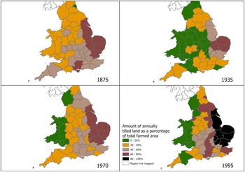
Figure 1 shows the marked changes in the regional concentration of arable land from 1875 to 1995. 1875 marks a point only two to three years after the zenith of the Victorian ‘high farming’ based on wheat as the key crop. Wheat prices had already begun to fall because of overseas competition, but it was too early in 1875 for cropping patterns to be significantly impacted. That was to come mostly in the 1880s and 1890s in the so-called Great Depression in British agriculture which saw a reduction in arable cropping across most areas.Footnote 30 The agricultural depression and a succession of governments’ content to increase reliance on food imports drove SWE farmers to concentrate on red meat and dairy farming because it required relatively low capital input and labour to produce perishable products relatively safe from import competition.Footnote 31 Arable production rose to greater prominence again during the First World War (WW), but fell away sharply after the repeal of the Agriculture Act 2020 just a year later.Footnote 32 A modest Wheat Act was introduced in 1932 bringing in a guaranteed price for wheat,Footnote 33 but it was not until the Second WW that there was a full recovery of arable production, with war heralding a significant swing back to arable production in the SWE in common with the rest of the UK.Footnote 34 The maps for 1970 and 1995 show a growing regional specialisation in arable agriculture, so much so that a higher proportion of Devon was under cultivation in 1935 than in 1995 despite the significantly increased overall national level of arable production in 1995.
The amount of annually tilled land as a percentage of total farmed area for the countries of England and Wales at four time intervals: 1875, 1935, 1970, and 1995. These data are reproduced from and with thanks to Robinson and Sutherland, 2002Footnote 29 . Ceremonial counties data – OS opendata Crown Copyright 2023.

In Fig. 2, we contrast the western grassland counties of Devon and Cornwall with Norfolk, an arable county in the east of England. The growth in the proportion of permanent pasture in Devon and Cornwall in 1991 is partly accounted for by the inclusion of rough grazing in the permanent pasture figure that year, having been either not accounted for or a separate category in previous years, but a significant part of the rise is to do with the decline in temporary grassland. As the area devoted to arable and other crops declined, so too did temporary grassland included within the rotation. As arable cropping was phased out so erstwhile temporary grassland became permanent pasture by de fault through the passage of time. Contrasting the 1875 and 1971 figures perhaps gives the best indication of the change. Cereals and other crops accounted for 41.5% of the agricultural area in Cornwall in 1871 with the comparable figures for Devon and Norfolk being 42.5% and 63%, respectively. So a clear difference between east and west but with the so-called pastoral counties of the far south west having not far short of half their area under arable cropping, this hardly suggests an overwhelming preponderance of land unsuitable for cropping. A century later, the arable area has halved in the west (23% for Cornwall and 20% for Devon), whereas in Norfolk it has increased to 82%.
Changing cropping pattern: Devon, Cornwall and Norfolk 1875–1991.

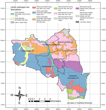
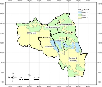
We turn now to the six parishes in central Devon that lie 25 miles west of Exeter and due north of Okehampton. The parishes, though partly in the rain shadow of Dartmoor, are wet (over 1000 mm or 40 inches) and contain a combination of very wet heavy soils and some free-draining soils. Figure 3 shows a remarkable variety of soil types for such a small area, and this is further reflected in Fig. 4 showing that three of the parishes (Jacobstowe, Exbourne, and Sampford Courtenay) contain Grade 2, 3, and 4 land. Grade 2 land is very good quality agricultural land defined as ‘land with minor limitations which affect crop yield, cultivations or harvesting’Footnote 35 capable of growing a wide range of agricultural and horticultural crops. Grade 3 land is good to moderate quality agricultural land ‘with moderate limitations which affect the choice of crops, timing and type of cultivation, harvesting or the level of yield’,Footnote 36 but certainly suitable for cropping if and when economic and market conditions are favourable. By contrast, Grade 4 is poor quality land ‘with severe limitations which significantly restrict the range of crops and/or level of yields. It is mainly suited to grass with occasional arable crops (e.g. cereals and forage crops) the yields of which are variable’.Footnote 37 The Devon Grade 2 land in this area is known as ‘red land’ and represents the western-most point of this land in the county. But Grade 3 land is widely spread alongside Grade 4 and 5 land in the west and north of Devon. Grade 2 and 3 land accounts for much of the land that was once routinely part of an arable rotation. We looked at historic land use data from the Agriculture Census for the 6 parishes, and the results are shown in Table 1.
May of soil type profile of 6 Devon parishes. Soilscapes data identifies different soil types (of a series of 30 predominant types identified) in a given geography at a scale of 1:250000. Copyright Cranfield University at Silsoe (NSRI) 2005. Parish data – OS opendata Crown Copyright 2023.

Agricultural Land Classification (ALC) Grades 2 to 4 mapped for the 3 Devon parishes. ALC grading 1(best) to 5 (worst). Source opendata.gov.uk, Provisional Land Classification ALC (England). Parish data – OS opendata Crown Copyright 2023.

Cereals as a % of total agricultural area in 6 Devon parishes.

aCereals include wheat, barley, oats, mixed corn, rye and beans/peas.
bTotal agricultural area does not include rough grazing as these data were not recorded for 1869, 1875 and 1881.
Source Annual Agricultural Census Parish Summaries: 1869 TNA MAF 68/180; 1875 TNA MAF 68/408; 1881 TNA MAF 68/750; 1891 TNA MAF 68/1320; 1900 TNA MAF 68/1833; 1911 TNA MAF 68/2460; 1921 TNA MAF 68/3021; 1931 TNA MAF 68/3561; 1941 TNA MAF 68/3976; 1951 TNA MAF 68/4346; 1961 TNA MAF 4718 & 4719; 1971 TNA MAF 68/ 5219; 1981 TNA MAF 68/5745; 1988 TNA MAF 68/6103 & 6104.
The data show the rapid decline in arable production in the 1890s and 1900 and even more so after the Second WW, during which time the 1941 National Farm Survey (NFS) was undertaken in which local surveyors were instructed to divide each holding into good, fair, and bad land. These were qualitative judgements based on conversations with the farmer and some on-site inspections. The results show that many farms within a single land capability grade were actually much more diverse than the grading might imply and few farms located on Grade 3 and Grade 4 land were entirely devoid of land suitable for cropping. Thus, most farms even in areas which the TOG narrative now characterizes as ‘only good for growing grass’, were likely to have land suitable for cropping, and that is borne out by both the good/fair/bad classification and the actual cropping recorded on such farms. Figure 5 gives just one example of a farm located in Exbourne parish, on Grade 3 land, some of which is very wet, showing its cropping pattern in the 1941 survey. Since the 1970s, it has been purely a grass farm, first with a dairy herd and subsequently with grass let for sheep grazing.
Lower Woodhall Farm, 101.5 acres in 1941.

Although farming of plants or animals is often framed in contemporary discourse as an either-or option, in practice there is a centuries-long tradition of the two co-existing in a symbiotic relationship. Albeit to varying extents, cattle and sheep have always been an important component of a mixed farming system in England – including the SWE – farmed both as a food output and an essential fertility building part of the arable and field crop rotations.Footnote 38 However, post-WWII, mixed farming was widely disparaged by agricultural reformers as an inefficient indulgence, practiced by farmers who persisted with the ‘superstition’ that they had a responsibility to do right by the land.Footnote 39 In their book, Mixed Farming and Muddled Thinking, Astor and Rowntree conclude:
[the] contention that mixed farming is essential if soil fertility is to be maintained is without any real basis […] an obsolete survival from the nineteenth century which is now as out of date as open-fields farming was a century and a half ago.Footnote 40
Astor and Rowntree’s book precursors the 1947 Agricultural Act which drove a science-led agricultural policy pivot away from mixed farming towards specialisation in which arable farmers were to dispense with livestock and replace them with chemical fertilizer and pesticides.Footnote 41 It gave rise to the eventual west-east bifurcation of livestock and arable farming in England that exists today.Footnote 43 By the 1960s, the UK’s productivist agricultural policy and attendant price support mechanisms were widely considered to be sufficient in themselves to safeguard the modern expert farmer from the risks of a downturn in market demand for their particular specialist commodity.Footnote 44 With experts and government advocating for science-led specialist farming, mixed farming was fast disappearing across the UK, as illustrated by this SWE farmer’s account of their farm’s (Farm 272) transition to specialisation recorded in the NFS, ‘in 1939 it was a mixed farm, by 1984 it was an all-grass dairy farm’.Footnote 45 Even so, many farmers were reluctant to abandon their mixed farming principles. This was particularly the case in the SWE, where mixed farming practices persisted into the late 1960s, viewed by many farmers as both the traditional and ‘right system’.Footnote 46 This view persists today, frequently expressed in interviews we conducted in 2022, as illustrated by this Cornish farmer who acknowledges their forebears’ wisdom in practicing mixed farming as:
…just proper traditional Cornish growing … “…like a lot of land around here… You know there’s good reason it was only ever mixed farmland. Farmer-Grower#2, Cornwall.
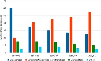
Some farmers in Devon and Cornwall continued growing a small acreage of vegetables as part of a mixed farming enterprise right up until the early 1980s, assisted by middlemen operating on behalf of regional wholesale markets,Footnote 47 a system that accounted for the marketing of 70% of fresh produce as late as 1970.Footnote 48 The deregulation of markets in the 1980s forced a radical shift of power and economic value down UK food supply chains to the fewer, bigger corporate food retailers in a process Dixon and Banwell coined supermarketisationFootnote 49 and an attendant shift to direct retailing from farm to supermarket.Footnote 50 As Fig. 6 shows, the supermarkets’ gradual dominance of fresh produce sales came at the expense of independent retailers and their wholesale market suppliers.
Changing share of fresh produce sales in different market outlets 1978–1990. Reproduced from Davies and Hope-Mason (2005).Footnote 42

The impact of the dominance of supermarkets is evident in an interview with a Devon cattle and swede grower who describes going from growing a few acres for market or to ‘put the sheep and cattle in’ to growing 1,000 acres of swede for supermarket retail on rented land across Devon and Cornwall. They reflected on the effect supermarketisation had on mixed farm enterprises locally:
There used to be a lot of swede growers around here, a lot of potato growers through the valley … I can think of one around here who still grows potatoes, but nobody else does, it’s the same old story…you’re not allowed to make money…you’re not allowed to make enough by the supermarkets to see you through the bad times. Farmer-Grower#13, Devon.
The combined effects of productivist agricultural policy, together with market liberalisation and de-regulation, also affected the other important fruit and vegetable growing sectors in the SWE. In the 1960s, government policy incentivised farmers to grub up old orchards.Footnote 51 Without an equally compelling incentive to replant those orchards, the consequence was that many orchards reverted to the dominant farming activity, namely pasture for livestock. In Devon, the area of land given over to orchard fruit fell by just under 95% between 1955 and 1985.Footnote 52
Policies that directly or indirectly encouraged a retreat from mixed farming and greater specialisation can be seen in other sectors too. For example, the Milk Marketing Board launched in 1933 had pricing policies that served to encourage an expansion of milk production in the SWE.Footnote 53 Direct subsidy of livestock production also served to encourage beef and sheep producers in the 1950s and 1960s.Footnote 54 Entry into the EU’s Common Agricultural Policy reinforced the trend towards specialisation, and the MacSharry reforms of 1992 served to both fossilize these patterns of production and increase the uptake of agri-environmental schemes.Footnote 55 It is important to note that there were some policies that did encourage the cultivation of arable crops. For example, the ploughing grants of the 1950s and 1960s had a high uptake in SWE,Footnote 56 although this was usually in the context of fodder for livestock. Similarly, the imposition of milk quotas in 1984 led farmers to seek to reduce the cost of bought-in concentrates, which led to more attention being given to grassland management and, in some instances, to more cultivation of fodder crops.Footnote 57
The agricultural journals – changing portrayals of farming driven by changing agri-policy
Here we look at two government-sponsored agricultural advice publications which together cover much of the second half of the 20th century. First, the monthly magazine entitled Agriculture was published by MAFF in the period 1948 to 1972. Second, the Agricultural Development and Advisory Service’s (ADAS) SWE regional publication Focus: Devon (also known as Devon Farming in Focus), was published in the period 1971 to 1992. In these pre-internet days, printed magazines were an important source of information for leading farmers and more especially farm extension officers, county agricultural college lecturers, and so forth. They, therefore, act as a useful barometer of concerns and issues occupying the minds of senior officials in the agricultural policy and science establishment. The aim of our review of editions of Agriculture and FD is to provide some illustrative examples of the prevailing views of the day rather than to suggest a systematic content analysis of the journal as a whole. If the far SWE was considered by these industry opinion leaders to be suitable only for grassland production, then we might expect that to be reflected in the content of the journal. In fact, our review reveals a more complex picture with two predominant themes emerging. The first theme is mainly concerned with the past and present, acknowledging the great diversity of land and soil types in the SWE and the resultant diversity of food production. This contrasts with the second theme that promulgates the forward-looking science-led policy push for specialisation as the means to achieve greater food security.
Turning to the pages of Agriculture, the following examples serve to illustrate the first theme, beginning with an article in the July 1952 edition entitled ‘West Country Landscape’, by Prof. L. Dudley Stamp, the then Honorary Advisor on Rural Land-use to MAFF, in which he sets out a comprehensive account of the diversity of growing conditions which underpin the region’s diverse food production:
It is not difficult, too, to understand the premium in Devon and Cornwall on shelter from the wind on well-drained slopes or on pockets of good soil, especially where slopes are banked up against the southern sun. Nor is it surprising to find in the south-western counties every type of land from the very finest market-gardens, famed for winter broccoli, early potatoes and other vegetables and fruits, to the poorest moorland which generations of farmers and, in some cases, unlimited capital, have failed to tame. […] The south-western counties enjoy special advantages of climate not yet fully exploited. Nowhere else perhaps are such uses to be made of pockets of land specially favoured by air drainage, exposure to sun, warmth of soil and other factors. […] an extension of the market gardening areas of Penzance for example—whilst the country around Newton Abbot affords numerous examples of the great range within a short distance in type of land and opportunities for farming.Footnote 58
In the same edition, in an article entitled ‘Devon: a county of Diverse Farming’, the County Agricultural Officer, set out five area-based types of farming in Devon, noting that ‘it should be emphasized that the bulk of farms are not devoted to a single enterprise but are true mixed farms producing several products’.Footnote 59 The following extracts below give a flavour of the article:
The Culm Measure belt across North Devon is given over very largely to mixed farming […] Around Exeter on the red soils there is a high proportion of arable land growing crops for sale, but meat and milk production are very important. Around Moretonhampstead, there is considerable emphasis on potato growing. In South Devon dairying is common with varying amounts of grain growing, especially in the extreme south. […] Market gardening is concentrated into three major areas ; although there are other less important districts, and a considerable area of vegetables is grown on farms as part of the ordinary rotation. In the Exeter-Dawlish district a wide variety of crops is grown, of which strawberries, violets and anemones are probably the most important. The Tamar Valley, with its steep sheltered slopes, is renowned for its soft fruit, daffodils and early potatoes. Combe Martin is a most remarkable area, comprising a narrow, steeply-sided valley with small enclosures and few holdings of more than 2 acres—all set in the midst of a rather bleak, exposed district bordering on Exmoor. It produces very early strawberries as its main enterprise, using early potatoes to give a rotation.Footnote 60
In expounding on his assertion of Devon as a county of diverse farming of which grassland is one – albeit significant – component, MacFarlan conveys his obvious familiarity with farming as practiced ‘on the ground’, which can reveal subtle differences to the picture captured by surveys. Notably, his observation of ‘the considerable area of vegetables grown on farms as part of the ordinary rotation’ highlights the importance of understanding the whole farming system, which snapshots from the Ministry of Agriculture’s annual surveys do not always capture. Rotational production within contemporary farming systems can also be eclipsed by survey methodology. DEFRA classifies farm type on the basis of the standard outputs of that type of production exceeding two-thirds of the total for the farm.Footnote 61 On predominantly livestock farms, this can obscure elements of rotational production, or as is common in Cornwall, of renting out fields to specialised horticultural producers for field vegetable production. Those livestock farmers ‘renting out’ land contribute to the fertility building and good rotational practices of the horticultural specialist producer in a symbiotic partnership which is less acknowledged in national discourse.Footnote 62 Towards the end of the article, MacFarlan gives a glimpse of the future policy-led direction of the county’s agricultural output:
Grants under the Hill Farning Act, and now the Livestock Rearing Act, are helping towards the improvement of many store stock farms over quite a large area in the county. The comprehensive schemes involving improvements both to the fixed equipment and to the land itself should assist in the current drive for more meat from home-grown food.Footnote 63
Some 20 years on, the ‘Farming Cameo’ series continued to reflect diverse production in Cornwall and Devon, while acknowledging grassland and ruminant livestock farming as the main farming activity in many areas of the two counties, as illustrated by these two extracts taken from the editorial series relating to Cornwall and Devon, respectively:
The temperate climate with freedom from frosts and a long growing period is ideal for grass growth […] The soil and climatic conditions in limited areas of east and west Cornwall are ideally suited to the production of bulbs and flowers, broccoli, early potatoes, and spring cabbage, with some soft fruit in the Tamar Valley.Footnote 64
And:
The farming systems adopted in this county are mainly the result of soil and climatic conditions. Grass is the crop that grows par excellence in most parts of the county, and as Devon farming is mainly concerned with livestock, the arable crops grown are mainly used for stock feeding. […] Potato growing is confined mainly to the larger farms on the lighter soils and much of the crop is sold as second earlies to meet the demand from the influx of summer visitors. Root and green crops make an important contribution to livestock feeding. Swede growing for human consumption is practised on the redland soils of South and East Devon. […]Horticulture is mainly located in the eastern and southern parts of the county with relatively low rainfall and, incidentally, also lighter and more friable soils. A flourishing co-operative growing and marketing organization for fresh vegetables has been established in East Devon.Footnote 65
Turning to the second theme to emerge from our review, as to be expected of a MAFF publication, Agriculture was a tool for promulgating the government’s productivist policy push for specialisation which for farming in the SWE meant narrowing its focus to the growing and improving of grass for the production of milk and red meat.Footnote 66 For example, an article in Agriculture (January 1951) entitled ‘A Policy pivoting on Grass’:
The south-west of England, by virtue of its soil and climate, has for long been regarded as essentially a livestock area with the emphasis on grass as the chief means of maintaining both cattle and sheep […] it behoves all those with livestock to plan now and put into practice forthwith all possible means for ensuring the essential self-sufficiency demanded by the times in which we live (emphasis added).Footnote 67
And in the October 1958 edition: ‘Increasing the productivity and efficiency of grassland […] is one of the biggest contributions British agriculture can make to easing our balance of payments difficulties’.Footnote 68
These extracts represent the progressive productivist view that SWE needs to focus on its strength and comparative advantage of growing grass. And that farmers in the national interest should – indeed had a civic duty to – focus on increasing efficiency and productivity of grass-based dairy/beef/lamb production.
The policy-led push for specialisation and concomitant decline in diversity of production is also the central theme in the ADAS regional publication Focus: Devon, which aimed to provide SWE farmers with advice on pests and diseases of both livestock and plants with the most up-to-date scientific strategies in order to combat them. Crucially, Focus: Devon was attempting to provide a place-appropriate translation of the wider productivist science-led policy environment that made sense for local conditions until personnel and their advice were gradually centralised during the late 1980s and early 1990s.
At regular intervals, Focus: Devon profiled cereal varieties available to the Devon farmer. Articles repeatedly cautioned, ‘many new varieties which do well in the East can be a disaster in Devon and Cornwall,’Footnote 69 and new and emerging varieties of wheat, oats, and barley in particular were trialed at sites in Devon and Cornwall to test compatibility with the region’s climate. For example, an entry in 1971 suggests ‘Midas, Akka and Clermont have not performed particularly well in the South-West and no more than a small acreage of any of them should be grown’.Footnote 70 The capacity for cereals to adapt not just the climate but also to benefit the mixed farmer is still evident in advice from the early 1970s, with winter cereals also praised for their capacity to provide ‘useful February and March grazing’.Footnote 71 Yet it would be a mistake to assume that these grains were being grown on Devon farms solely for livestock consumption. Varieties within Focus: Devon articles are profiled for their performance in breadmaking or malting, for example.Footnote 72 European Union intervention standards provided a safety net, and those quality varieties, which on harvest were found not to have made the grade for food production, still brought in a return to the farm.Footnote 73
From 1978, the Focus: Devon also included a horticultural supplement at regular intervals, with advice particularly tailored to the crops and husbandry of the horticultural grower. In contrast to contemporary perceptions of what horticultural production is possible in Devon, a wide range of horticultural crops were considered worth profiling, including raspberries, onions, and tomatoes, for example.Footnote 74 In later editions during the early 1980s, horticultural crops are being promoted as a viable diversification project for Devon farmers. In 1982, for example, Devon hill farmers were encouraged to try seed potato growing, the advisor suggesting that the practice offers, ‘the chance to make full use of farmyard manure by putting it under a cash crop’.Footnote 75 However, increasingly articles cautioned livestock farmers against engaging in non-specialised horticultural growing, as this extract from 1985 suggests:
Is this for you? If your first thought is, “if I can’t sell it, I can feed the sheep,” then very definitely not. Part time horticulture is no answer, this is a crop that demands a high degree of skill and expertise to produce a Class I product.Footnote 76
Advice elsewhere in Focus: Devon points to stringent horticultural marketing requirements driving capital investment in specialised equipment, ‘which would be uneconomic if the crops are only to be spot grown’.Footnote 77 Although Swede growing perhaps represented one of the last bastions of mixed farming in Devon, the old practice of growing some for the market and keeping the rest for the livestock was also under pressure. Swede growing was also becoming an increasingly specialised enterprise, advice in 1990, for example, suggests that:
…to continue supplying the ever more exacting standards set by supermarkets and retailers, producers must constantly be aware of all the latest technology either in extending the cropping season with quality produce for both early and late swedes, or by growing a crop that will give the maximum percentage of culinary quality swedes and the minimum percentage of waste.Footnote 78
As farmers were being urged to specialise, so were the advisory services. May 1989 marked the last issue of the magazine that contained a dedicated horticultural supplement; while some issues after this date carried advice on horticultural matters these concerned a narrower range of crops. Swede production continued to be the subject of articles, but the advice betrayed the diminished capacity of the advisory services to guide these specialised producers. A 1989 article contrasts the increasingly stringent quality standards from supermarket buyers with the diminishing capacity of chemical controls to deliver that quality. This issue also notified local growers of the withdrawal of funding for ADAS to carry out research and development on cabbage root fly, the primary pest of swedes.Footnote 79
By the 1980s, the tone and emphasis of cereals advice is also shifting. The divergence in capacity between livestock farmers growing dual-use cereals and specialist arable growers can be identified, as in this extract from 1983:
Cereal growing in the last few years has been characterised by a modest increase in acreage, a steady increase in yield, and latterly a considerable swing to winter corn. However, there is evidence to suggest that the installation of new drying facilities and the uprating of existing plants has failed to keep pace with the ever increasing quantity of grain which has to be marketed […] the farms chiefly at risk are those where grain is used for stock feeding, but where over the years an increasing amount surplus is sold off. In the main, specialist growers have uprated their handling and drying facilities over the years and can, at the moment deal adequately with all the grain they produce.Footnote 80
Advice to farmers clearly reflected the now established orthodoxy of productivist agriculture. ADAS advisors writing in Focus: Devon, reiterated the inefficiency of cereal growing on predominantly livestock farms. An article in January 1986 asks ‘many livestock rearing farms grow spring barley, but is it the right choice of crop? Examine your reason for growing the crop’.Footnote 81 Around the same time, different issues of the Focus: Devon begin to indicate the structural shifts underway in the architecture of farming advice and support delivered by ADAS. March 1987 details the introduction of charges for ADAS services, with specialist subscription groups for cereal growers and specialist advice centres established in other locations.Footnote 82 Increasingly, arable and horticultural advice comes from ADAS personnel in Bristol or Cambridge, and arguably, the quality of the advice diminishes once it is no longer tailored to local growing conditions.
Overall, these illustrative extracts support our argument in two respects. First, while the SWE is undoubtedly good at growing grass, it is inaccurate to label the SWE as a region that can only grow grass. Far from it, the region’s topographical, climatic, and edaphic diversity is conducive to growing a range of plant and animal foods for human consumption. Second, that the TOG narrative has, in large part, been brought about by the twin political and economic forces of agricultural productivism and the supermarketisation of the supply chain, rather than by SWE farmers themselves, many of whom were resistant to giving up mixed farming. But as noted in The Real Agricultural Revolution, by the 1980s, this sustained push to get farmers to specialise had taken effect:
developments in science and technology, coupled with education and advice, changed what farmers knew; agricultural policy changed their beliefs.Footnote 83
Returning to the present day, the underlying dynamics of the TOG narrative was found in the responses to the 2020 SWE Farm Survey,Footnote 84 which asked land managers whether they would consider fruit or vegetable production on their holding in the future. Of those who provided a free text response (n=528), 37% identified the soil, climate, or topography of their holding as being unsuitable, despite the survey being broadly representative of a range of holdings and soil types. The next most common reasons were ‘not interested in horticulture/different skill set’ (23%) and ‘profitability concerns/marketing concerns’ (11.5%). In-depth interviews also reveal some counterpoints to the TOG narrative, first in relation to soil suitability as illustrated in the following extract:
It’s just some like weird myth that like there’s some magical soil. There are better soils than others, and there are better soils for some things, and the soil around Exeter is excellent, but like you can… veg definitely grows in most soils. Farmer-Grower#5, Devon.
The consolidated supermarketised supply chain and concomitant decline of diversity of independent marketing outlets has been a significant driver of the TOG narrative. First in fueling a self-fulfilling prophecy about the limitations of the soil:
I was talking to a tractor driver up at the winter fair on Saturday that works for one of the big farms that let a lot of ground to[supermarket grower]. He was just shaking his head to me, “Oh it was just wrecking this ground, just wrecking it” he said […] “just pushing the ground as hard as they can to get that crop that they want and then then another grower will come in behind and push it as hard as he can to get his crop”[…] whereas there’s like a lot of land around here… there’s good reason it was only ever mixed farmland. Farmer#2, Devon.
Second, in bringing about a rapid decline in the number of marketing outlets that can provide an accessible route to the market for mixed farmers, supermarketisation has contributed to the decline of mixed farming practices. Our interviews in 2022 revealed how even within living memory, the number of marketing outlets for fresh produce accessible to mixed farmers has dramatically declined, helping to drive the decline of mixed farming practices. For example, a farmer grower we interviewed recalled that during the 1970s:
… most farmers around here tended to grow a field of swedes at that time and if you didn’t pull them and sell them in nets to Covent Garden or somewhere, then you put the sheep in or the cattle in. Farmer-Grower#13, Devon.
One former fresh produce intermediary explained how the dearth of marketing options drove interdependence with the supermarket system, to the detriment of resilient production systems:
Because the supermarkets are so big now, you don’t have an option. I mean I used to deal with the food service companies, the wholesale markets, the supermarkets, there was a balance in the business if something was going wrong. The supermarkets got so big; they have 90 odd percent of our business. And if they said jump, you have to jump. Intermediary#11, Devon.
By contrast, the following extract suggests where efforts had been made to re-open markets to the region’s producers, more diverse production was restimulated:
talking to a neighbour who I’ve known for years, and I’ve got a lot of respect for, he said, “well, have you considered growing organic crops for local box scheme?” He said, “I’m doing it this year for the first time. They’re looking for growers”. Farmer-Grower#14, Devon.
As previously stated, growing awareness of the triple climate, health, and environmental crisis presents a challenge to the SWE and other English grassland regions where the principal farming activity is red meat and dairy production. But the crisis also presents a potential opportunity as attempts are made to reduce reliance on inputs through more integrated and regenerative farming systems with greater emphasis given to multifunctional land use as payment for public goods replace area payments. This potentially offers greater scope for nature recovery and other environmental services alongside more diversified food production. The principles of mixed farming are currently enjoying rehabilitation, with the diversity of food production emerging as an essential component of a just, sustainable food system.Footnote 85 Advocates of agroecology in the UK emphasise the causal connection between more diverse and balanced food production with more diverse and balanced diets.Footnote 86 The UK’s main agroecology farming conference has seen numbers increase 10-fold in the past 10 years.Footnote 87 Interviews with farmer-growers reflected this interest:
A lot of our land is quite thin…so there wasn’t a standing case for keeping going on intensive farming… so in order to have the fertility building phase for the organic arable we’ve got quite a large area of herbal leys so we can keep those sort of four or five years…We bought a herd of pedigree Herefords [cattle] to graze them. I mean, it was quite a sea-change. Farmer#3, Gloucestershire.
So I’ve had some of the big veg boys ask me about Dexters [cattle]. “Oh, what animals, what beef animals would follow on a heavy cauliflower field?” or whatever… so it’s interesting how those boys are thinking, especially to do with soil structure, getting organic matter back into the soil. Farmer#18, Cornwall.
Conclusions: what the traditionality of grasslands narrative really tell us
Our research approach has facilitated a more nuanced understanding of the TOG narrative in the SWE, leading to several insights. First, farmers and the land that they farm are perhaps the least immutable or obstinate block to achieving a transition to diverse and sustainable food production in the SWE. Indeed, their embedded knowledge, often held across generations of farming families, makes farmers a key asset in delivering the required food system transition. Second, farming’s promulgation of the TOG narrative serves to reify grasslands as being suited only for food produced from grazing livestock and risks unintentionally discounting the potential that exists for grasslands, and their farming communities, to align food production with the public’s need to transition to more balanced, diverse, and sustainable consumption. Third, a more nuanced reading underscores the role and responsibility of public policymakers in determining whether the social, political, and economic dynamics of the wider food system act as barriers or gateways in enabling farming to transition to sustainable health-orientated food production.Footnote 88
What becomes apparent from the historical perspective is that farming’s narrative about what land is good for has been influenced and shaped as much by ‘events’, and the policy responses to them, as by the inherent qualities of land and soil types. The TOG narrative intertwines the physical limitations of land with human-made limitations of the social, political, policy, and economic dynamics of the wider food system. This complex bundle of factors has become fused into a simplistic narrative that, unintentionally or otherwise, serves to reify grasslands as only fit for grazing livestock. Grassland and farming practices that incorporate grazing livestock will continue to be a culturally, socially, and economically important part of food production in the SWE and the most significant farming activity by area. However, the farming industry’s continued promulgation of an overly simplistic TOG narrative risks marginalizing the contribution the region – and its farmers – can make to the country’s transition to a healthier and more sustainable society, through diversified food production, as well as through the provision of nature restoration and environmental goods.
Acknowledgements
This research benefitted from an emeritus fellowship grant to Michael Winter (2022-24) awarded by the Leverhulme Trust. The authors thank Ruth Swetnam for help on mapping.


 Open access