
In 1966, the first governmental hospital, Oshakati hospital,Footnote 1 was inaugurated in Ovambo in present-day northern Namibia, not far from Onandjokwe hospital, run by Finnish missionaries. Although the two hospitals shared the common aim of providing the local black population with healthcare services and while close in geographical space, they were also separated by ideological distances that made them, in certain respects, absolute opposites. At the same time they were two sides of the same coin, intertwined and linked in other ways.Footnote 2 The two hospitals together constituted the centre of the medical landscape that materialised over the years to come; a landscape created not only through the provision of healthcare and well-being to people according to their needs, but also by missionary Christianisation efforts, and warfare, in the form of strategic considerations and military operations. The healthcare facility provision in this area was a product of transnational exchange, international politics and apartheid. The history of hospitals and health facilities in Namibia is fragmented and unclear, in particular in the north.Footnote 3 This article aims to contribute to this history, which goes back to the early twentieth century.
The South African Mandate and Healthcare
Healthcare facilities, such as hospitals, are a basic component of a healthcare infrastructure. When South-West Africa became a League of Nations C-mandate after the First World War, administered by the Union of South Africa, improved health was embedded in the mission stated in the Mandate. It was decreed that ‘The Mandatory shall promote to the utmost the material and moral well-being and the social progress of the inhabitants of the territory’.Footnote 4 In order to fulfil these requirements, contributions were necessary at a number of integrated welfare levels, of which the provision of healthcare was one. However, the League of Nations C-mandate did little to protect the inhabitants in South-West Africa from abuse by the colonial power, as was intended.Footnote 5 South African discriminatory healthcare practices led to deteriorating health and well-being in a number of ways for the black people in South-West Africa.Footnote 6 The major reason for the South African administration to develop biomedical care in South-West Africa was to sustain the labour supply of black people and to protect the health of the whites.Footnote 7 The meagre provision of healthcare to black inhabitants, including low quality or total absence of healthcare infrastructure such as hospitals, was one consequence of this policy.
Hospitals were few in number when South African administration began. The German colonial authority had built a few facilities for the military as well as civilians in the southern part of the territory.Footnote 8 The German military hospital in Windhoek was taken over by South Africa in 1915.Footnote 9 A segregated healthcare system was already in place and South Africa continued to build on this system, aggravating the health inequalities between whites and blacks. In places of importance to the white population, such as Windhoek, Outjo, Lüderitz and Grootfontein, state-aided South African hospitals were available to whites by 1920. Roman Catholic missionaries ran hospitals in Windhoek and Keetmanshoop for white patients. There were few healthcare options for blacks. The Roman Catholic facilities in Swakopmund and Gobabis provided segregated services to both blacks and whites.Footnote 10 Biomedical care to the black population was arranged by mining companies for their labourers in Kolmanskop, Lüderitz and Tsumeb.Footnote 11 Other facilities for the black population in the southern part of the territory were the Native Hospitals in Windhoek (100 beds), Keetmanshoop (18 beds), Karibib (12 beds) and Omaruru (8 beds).Footnote 12 The Native Hospital in Windhoek was of such poor quality that black patients avoided using its services. The Location Clinic which opened in 1929 was of higher quality and was more attractive to the black population.Footnote 13
Colonial space was defined through the healthcare system with the central hub of Windhoek. The District Surgeon system that was introduced after the First World War did little to alter this highly centralised system. The system provided major urban areas with a doctor while most staff resources were located in Windhoek and the mining towns. The Native Hospitals did not have permanent doctors, but were visited by the District Surgeons.Footnote 14
The northern part of the territory suffered particular discrimination as regards South African healthcare provision. Only one District Surgeon was on duty in Ovambo from 1929,Footnote 15 although the area was the most densely populated of South-West Africa and was where approximately 40–45% of the total population lived. In 1921, about 91 000 people inhabited this very small area. The population of this region grew at great rate and in the 1960 census, maintaining its share of the total population, this number was about 230 000 out of a total of 526 000 inhabitants in South-West Africa.Footnote 16 Whites were about 12%.Footnote 17
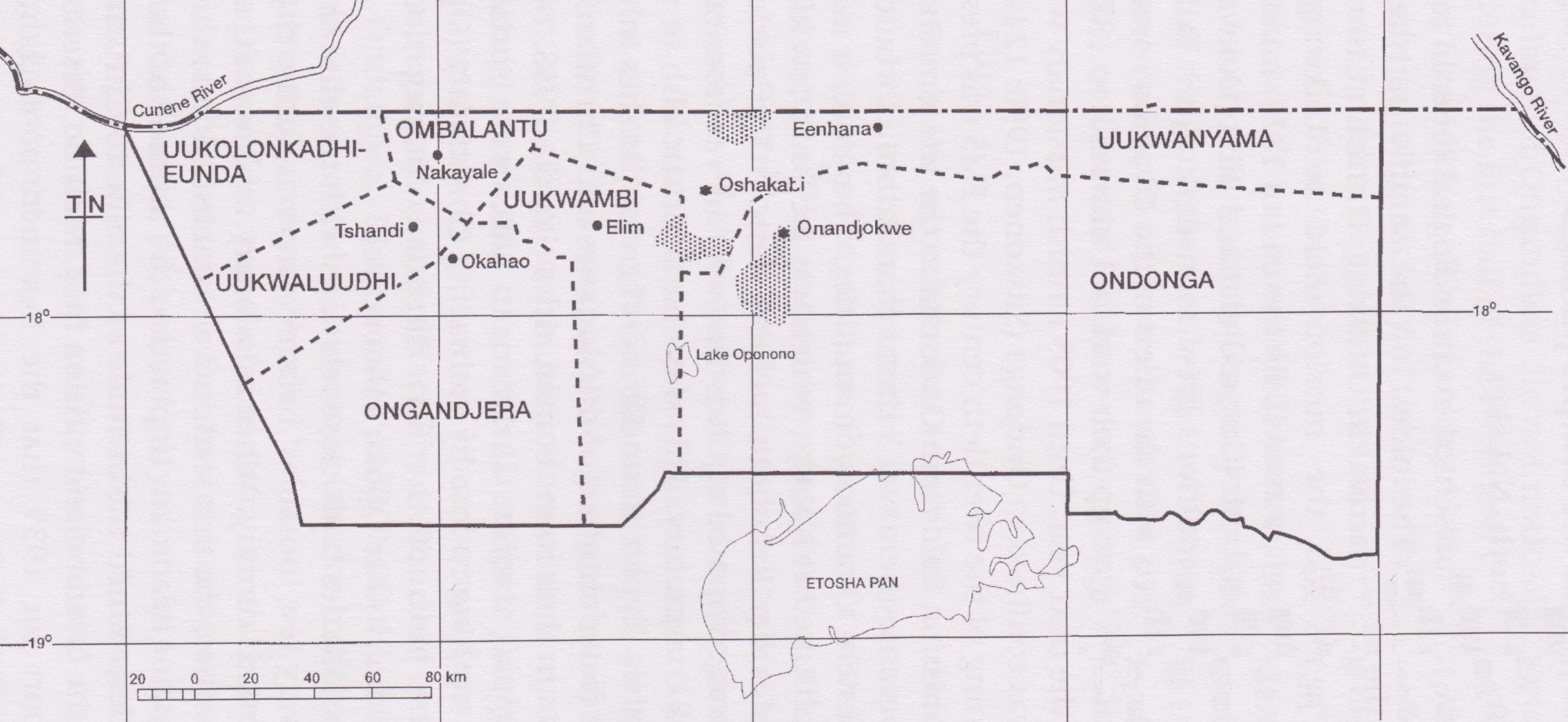
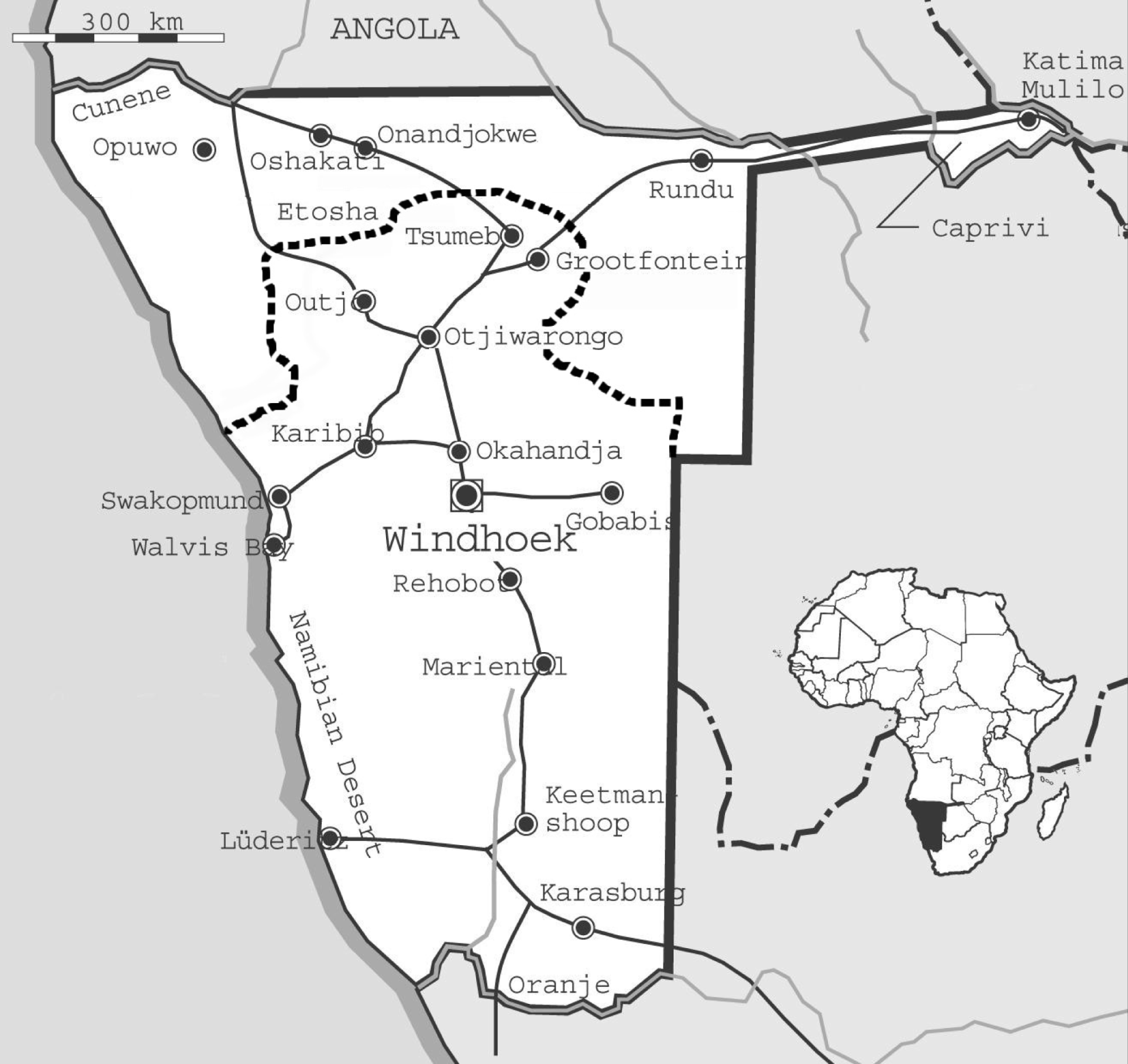
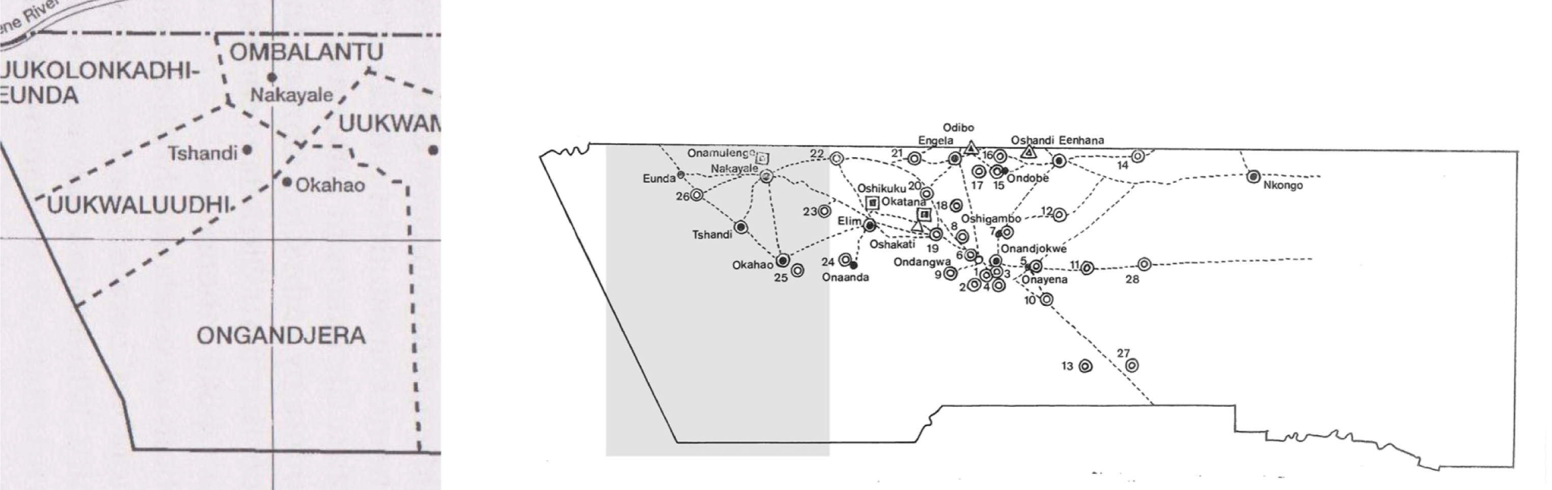
The people in Ovambo constituted seven groups of cattle owners and farmers living in scattered villages and farms, with similar cultures, languages and political structures. They were the Okwanyama, Ondonga, Uukwaludhii, Ongandjera, Ombalantu, Uukwambi and Uukolonkadhi (Figure 1).Footnote 18 The area was managed by local leadership, kings and headmen, according to traditional land distribution rules. To South Africa, these people constituted a reserve of manpower for the growing mining industry and for other employment requirements in the south. Ovambo was the focus of South African interest as a provider of predominantly male workers.Footnote 19 White farmers were encouraged to move in from South Africa and settle in the vast southern territory. They were dependent on the workforce recruited as contract labourers.Footnote 20 The division between the northern and southern parts of the territory was legally sanctioned during the 1920s and formally mapped off with a ‘Red Line’ (Figure 2).Footnote 21 The South African administration in the north was small and whites were not allowed to live in the area. Most of those who did were missionaries.Footnote 22 South African healthcare in the northern part of South-West Africa was to a large extent connected to the provision of manpower to the southern area. From the 1920s there were medical staff stationed in the north who were involved in the recruitment of people for labour contracts, primarily to conduct examinations and giving immunisations.Footnote 23 For all other biomedical healthcare provided to the indigenous people, the South Africans relied on the missionary contributions.
Map of the seven Ovambo groups. Source: Notkola and Siiskonen, (note 18), 33.

Map of Namibia. The dotted line indicates the border (the Red Line) between northern and southern parts in 1937. Sources: Africa Groups of Sweden (map); Wolfram Hartman et al., The Colonising Camera. Photographs in the Making of Namibian History (Cape Town: University of Cape Town Press, 1998), viii.
Missionary Medical Contribution
At the time the Oshakati hospital was opened, three missionary societies had provided biomedical healthcare to local people for about fifty years: the Anglican Missionary Society, the Roman Catholic Society and the Finnish Missionary Society. The contribution of the Finnish missionaries was substantial, especially in Ovambo.Footnote 24
In 1908, Dr Selma Rainio arrived in Ovambo from Finland.Footnote 25 She joined the Finnish missionary team that had been operating in Oniipa since 1880. Her arrival meant that medical care could be provided to local people on a more professional and regular basis. During her first posting, she saw outpatients in huts outside the little building where she stayed. However, the plans for the construction of proper buildings soon started.
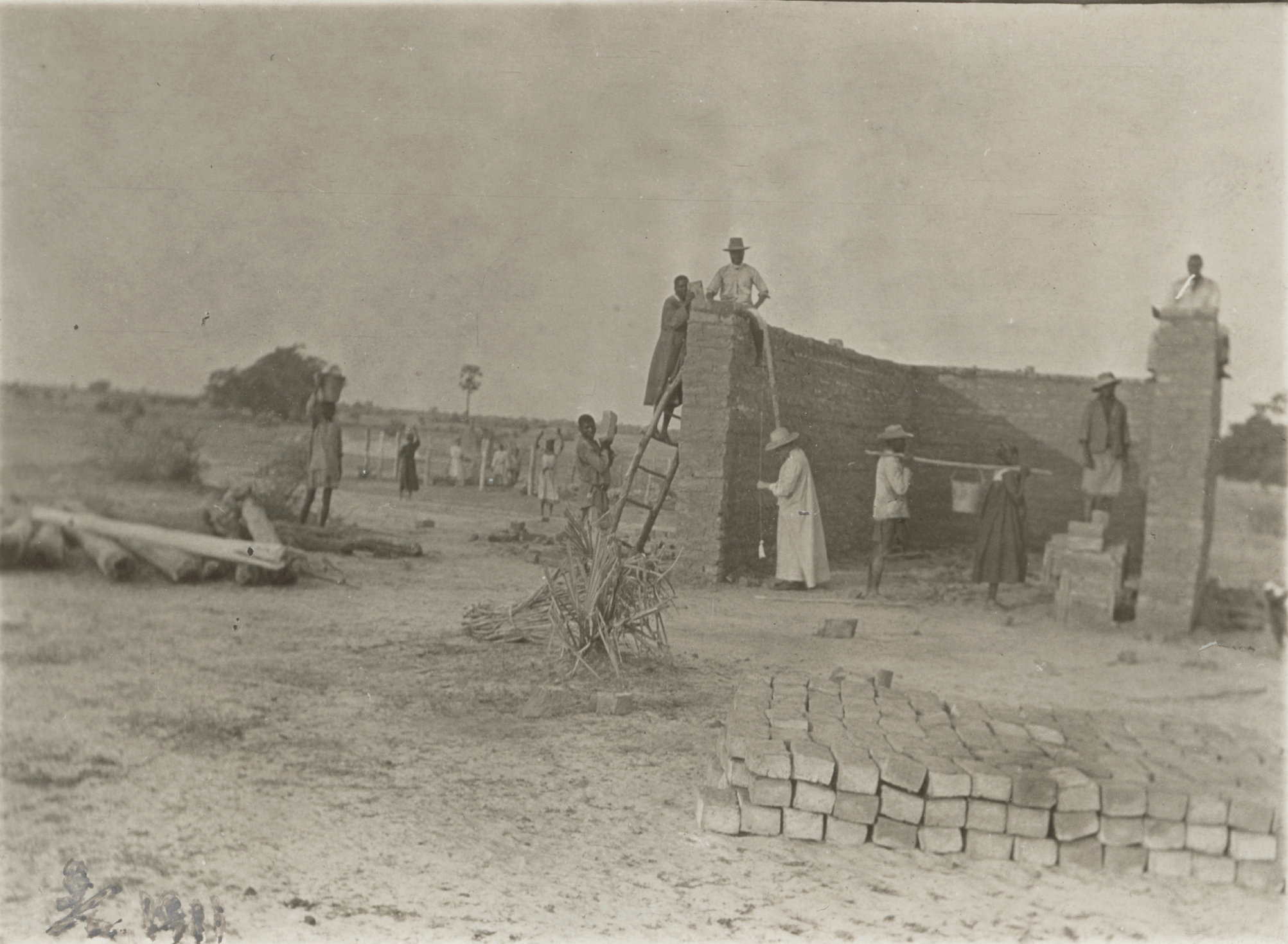
Selma Rainio (in the white robe and hat) measures the wall during construction work with adobe bricks performed by her colleagues in Onandjokwe. Photo: Hannu Hahti. Courtesy Kumbukumbu – Finnish Evangelical Lutheran Mission Museum.
A Hospital Made of Clay
The first building of Onandjokwe hospital was constructed of adobe bricks. It contained seven living rooms, a kitchen and a storage room for groceries. This building, which also contained an outpatient clinic and an operating room, was inaugurated on 9 July 1911. During the following decades, the hospital was extended with both smaller and larger buildings for dwelling or for healthcare purposes. Some were simple structures, such as storage rooms, workshops or sheds. Accommodation for staff and patients and a few larger buildings for medical services were finished between 1912 and 1926.Footnote 26 The larger buildings had a veranda, which followed the entire length of the house with an overhanging roof giving shadow to the veranda as well as the interiors. All were clay buildings (Figure 3). The roofs, often covered with thatch, were supported by tree trunks, and provided shelter for patients waiting to be seen by the doctor.Footnote 27 Much of the healthcare was provided on an outpatient basis. The Finnish nurse Karin Hirn who served at the hospital in the 1920s described the work in the booklet ‘Below the Southern cross’: Footnote 28
‘Then the treatment starts. Already in the early morning there are patients from outside. Mothers with the kiddies on their backs well tucked up in their skin bags, as well as others. Some have come from far away, others from the vicinity. The doctor examines and gives prescriptions. Very soon a big crowd is gathering outside our door. One after another they are called, examined, get their medicine and leave again.’Footnote 29
The hospital also had the capacity to provide inpatient care. Surgery was carried out at the hospital but that demanded a reorganisation of the few indoor spaces available. Selma Rainio writes about a male patient with an abscess in the stomach:
‘A man is to be operated on but first (…) the outpatient clinic needs to be turned into a theatre (…) The nurses prepare (…) for the surgery. If we want to use the daylight we cannot delay the operation very long since the afternoons in June are short.’Footnote 30
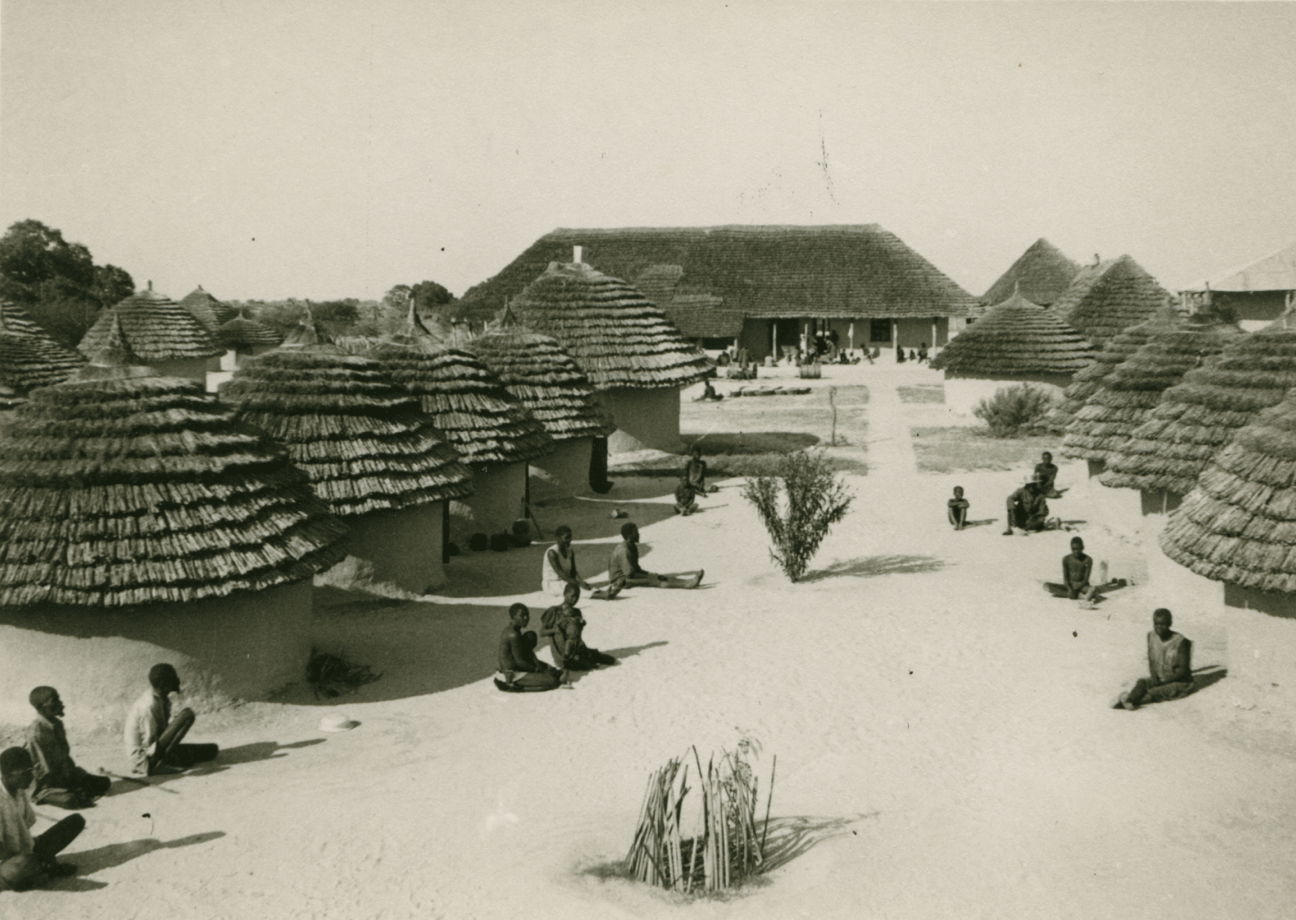
Inpatient accommodation was provided in huts erected for the purpose, where patients and accompanying family could stay (Figure 4). Karin’s narration reveals that the missionaries’ perceptions about local people’s habits influenced how they arranged the environment for the patients:
‘When the work slows down at the policlinic I go to nurse the severely ill. They lie in small round huts, with low ceilings. We have tried to arrange these in the way they do at home so that they get on better. A mother, a sister or some other relative sits and stirs a round, black claypot over the fire. The sick person lies on a straw mat.’Footnote 31
To the missionaries, medical care was not a healthcare undertaking alone but was intermixed with religious ambitions and proselytising. It was presented as a work of love, a gift to people as a sign of the passion for God. A nurse in Onandjokwe hospital expressed the missionary conviction by saying that ‘the medical work blessed by God can contribute to the expansion of God’s realm’.Footnote 32 The missionaries were primarily evangelists, and medical care had second priority.Footnote 33 Healthcare was used to attract people to the Finnish missionary hospitals where they were approached with a religious aim.Footnote 34 This was a successful strategy. Even people who wanted to have little to do with missionaries in general could be approached by means of medical care.Footnote 35
Huts for inpatients and accompanying relatives at Onandjokwe hospital. A larger building with thatched roof, for diagnostics and treatment, is in the background. Photo: Anni Melander. (K 1517) Courtesy of Kumbukumbu–The Finnish Evangelical Lutheran Mission Museum.
Finnish Missionary Healthcare
Due to the success in offering healthcare, Onandjokwe hospital expanded in a continuous process. In 1932 the hospital had ‘17 rather large buildings, 49 round huts and 15 sheds’.Footnote 36 The hospital offered a combination of curative treatment and primary care. Common diseases that were dealt with included malaria, venereal diseases, influenza, leprosy and injuries. Malaria was rampant, especially in those years when the rains were heavy. In 1949, 40 000 outpatients were treated for malaria in Onandjokwe. Vaccinations against smallpox, plague, diphtheria and poliomyelitis were carried out in campaigns during the 1940s and 1950s.Footnote 37
At the time Oshakati hospital opened, the Onandjokwe hospital had been modernised. A fire in 1958 sped up this progression. Huts and other buildings that were destroyed in the flames were replaced with new inpatient wards, a maternity ward and clinic, a ward for infectious diseases and a tuberculosis ward. Tuberculosis was treated by the Finnish missionaries only. Late in the 1940s, Onandjokwe got an X-ray facility which could be used for diagnosing the disease. Tuberculosis patients were isolated at the hospital.Footnote 38 The hospital was equipped with a new operating theatre.Footnote 39 In 1963 the use of torches or the reliance on daylight during operations came to an end when the hospital received electricity.Footnote 40
Finnish missionary healthcare services also started to expand in other places in Ovambo after the First World War. Over the next four decades the missionary society opened about twenty clinics and small hospitals in different places throughout Ovambo (Figure 5). They were simple buildings constructed in the same way as the Onandjokwe hospital, and often staffed by nurses.Footnote 41 Physicians were in short supply. Up to the 1980s, about ten doctors served in total on five- to six-year contracts. The majority of these were women. There was normally only one doctor in charge at any one time. From the 1960s onwards, three doctors were contracted; however, not during the war period when only one doctor staffed Onandjokwe hospital.Footnote 42
Map of healthcare facilities in Ovambo in the 1960s. Source: Kyrönseppä, (note 25), 2.
The South Africans subsidised Finnish missionary healthcare from the 1930s, although irregularly.Footnote 43 The missionaries were subsidised to 80% from 1962, and from 1966, to 100%.Footnote 44 However, the contribution made by the South African government was small in relation to the number of people living in Ovambo. The Finnish missionaries treated 14 600 inpatients and 160 000 outpatients at their hospitals and clinics during 1960.Footnote 45 In this year, about R90 000, out of a total sum of R1 260 000 for the entire country, was allocated to healthcare in the whole northern sector, including areas outside Ovambo.Footnote 46 The Finnish Missionary Society contributed R110 000 the same year.Footnote 47 The fact that there was no state hospital in the north is one conspicuous example of this biased allocation of resources.
South African Social Engineering in the North
Up to 1960 the medical services in South-West Africa followed a similar pattern to that in many other African colonies. Too few facilities, of low quality, providing inferior care, were available for the indigenous people, while whites were offered healthcare of higher quality in good facilities. Most hospitals and other facilities were provided close to the colonial centres, while the colonial powers relied on missionaries in other places.Footnote 48
However, during the 1950s, the political situation changed dramatically in a number of important ways. In the ten years after 1957, the majority of colonies in Sub-Saharan Africa gained independence.Footnote 49 In South-West Africa the nationalist movement started to organise itself with the foundation of the OPO, the Ovambo People’s Organization, in 1959. Some years later, SWAPOFootnote 50 was born which would eventually lead to South-West Africa becoming Namibia three decades later. In this context, the South-West African future was discussed and negotiated at an international level and the South African apartheid policies were subject to intensified international debate and criticism. A pivotal issue was a juridical one; whether South Africa had the right to remain in control of South-West Africa or not.Footnote 51 An early legal intervention in 1960 was the Ethiopian and Liberian effort to raise a case against South Africa regarding South-West Africa in the International Court of the Hague. However, the case was dismissed for the reason that these countries were not eligible to raise the case in the first place.Footnote 52
South Africa did not stay passive to the threat of losing control of the Namibian territory. Likewise, it had to deal with the international criticism of its neglect and abuse of the people in South-West Africa in order to strengthen its position in the UN negotiations and in the eyes of other international bodies and critics. A South African solution to these two problems was presented in the Report of the Commission of Enquiry into South-West Africa Affairs 1962–63 (the Odendaal Plan) which was a plan to formally implement the apartheid system in South-West Africa.Footnote 53 This report suggested that a system of native reserves should be introduced, and implied that the territory would eventually be integrated as the fifth province.Footnote 54 The plan was rejected by the UN. In 1966 the UN General Assembly stated that it was ‘gravely concerned’ about the situation in South-West Africa, and in resolution 2145 they declared that ‘South Africa had failed to fulfil its obligations (…) to ensure the moral and material well-being and security of the indigenous inhabitants’.Footnote 55 Yet in defiance of the criticism put forward, South Africa implemented the homeland policy in South-West Africa from 1968.Footnote 56
The international criticisms South Africa faced concerned, among other things, health issues. There was a particular focus on health services in the Odendaal Plan. It was suggested that Ovambo should be a homeland of its own, Ovamboland, and would be improved in a number of ways. The report recommended a substantial increase in the capacity and quality of services in the north. Staffing, equipment, education, medical and material supplies and infrastructure were to be improved and enlarged.Footnote 57 The decision to construct a governmental hospital in the north had already been taken in 1961.Footnote 58 The construction was indicated in the report as a desirable step in the development of the healthcare services.Footnote 59 The South African government may have expected that the fact that it was a large capital project of strong symbolic value would impress the international audience.Footnote 60 It was probably expected to be a physical representation of the omnipresent state and signify ostensibly a thorough South African engagement in the health of the northern people.Footnote 61 Finnish missionaries welcomed the Odendaal Plan since they approved of the seclusion of Ovambo.Footnote 62 They also expected that conditions that had been internationally criticised and held to be the responsibility of the South African administration of Ovambo would be rectified if the report’s recommendations were realised. They also looked forward to the great infrastructural improvements that were envisaged in the plan.Footnote 63
The New Hospital in Oshakati
In 1966, Oshakati hospital opened. The construction had been carried out in a notable way. The hospital buildings were made of prefabricated asbestos walls and iron sheet roofing produced in South Africa and transported an approximate distance of 2500km by train to Tsumeb, 300km south of Oshakati located south of the Red Line. The lack of building materials in Ovambo was pointed out during the planning of the hospital, and sourcing the building materials from South Africa was a means of overcoming this deficiency.Footnote 64 The large and heavy building components were reloaded from the train to lorries and the transportation continued to Oshakati where the walls were erected. This was done with great difficulty, according to the head nurse of the South African local administration. ‘Problems galore!’ she exclaims in her article.Footnote 65 The extremely awkward production and transport of the building elements suggests that the South African authorities had little confidence in the resources of northern South-West Africa. The German habit of using local building materials and hybrid architectural forms that blended with local architecture was not copied by South Africans.Footnote 66 The Germans had produced both cement bricks and adobe bricks; construction materials based on local matters the South Africans obviously did not adopt in the northern areas.Footnote 67 Neither were building techniques adapted to local resources even though people from the area were recruited as labourers. Even concrete ballast came from Tsumeb.Footnote 68
The Design of the Hospital
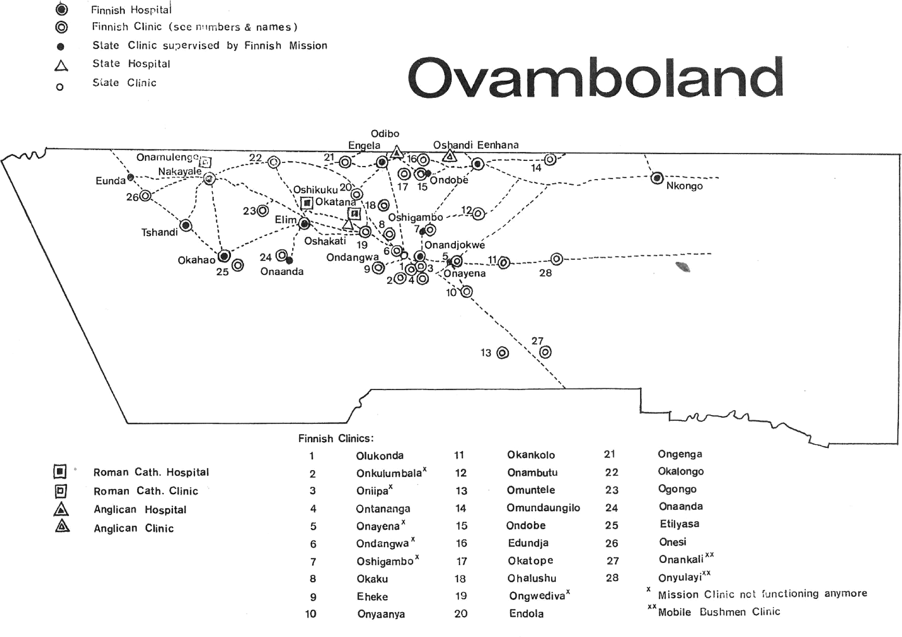
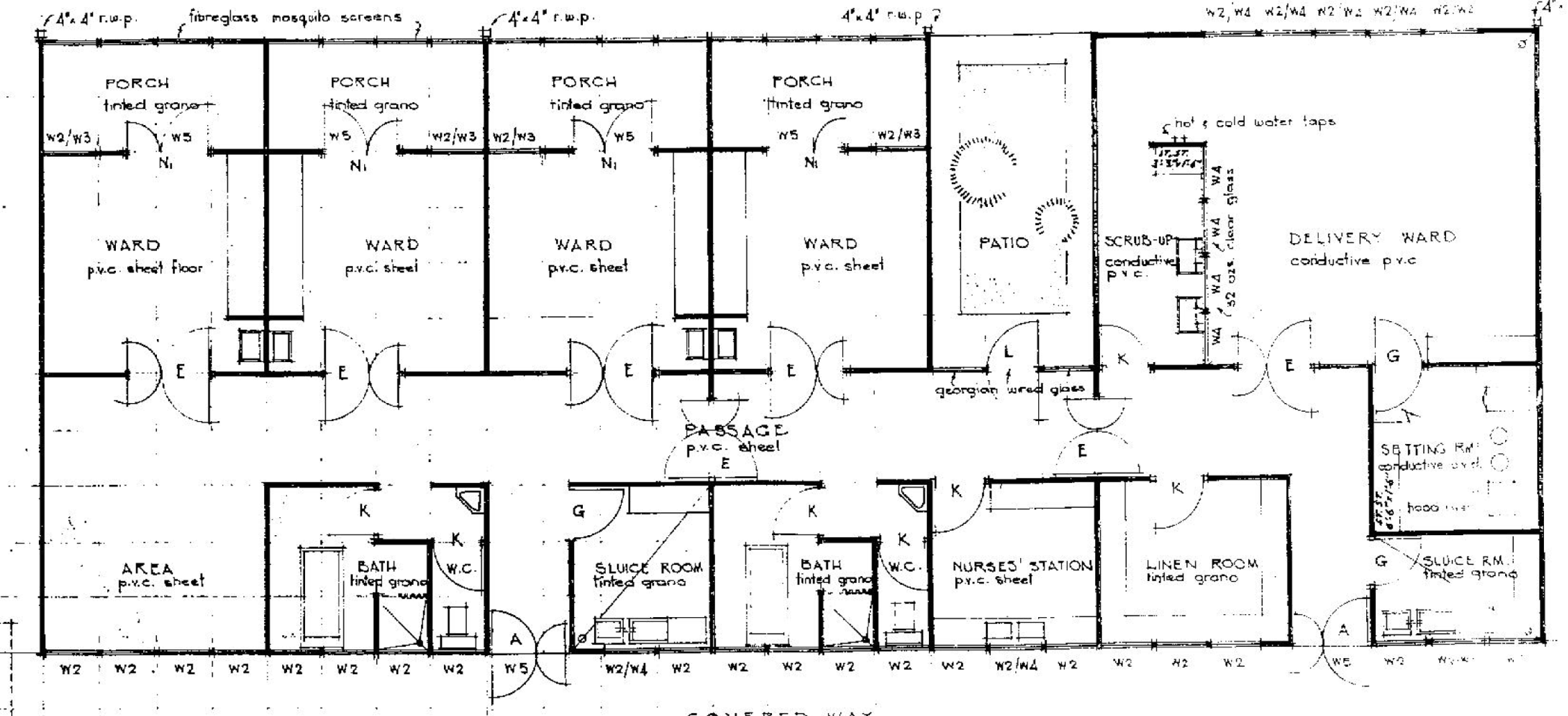
When the hospital was inaugurated it was severely undersized for its mission of serving the approximately 230 000 people living in the area.Footnote 69 The hospital had 444 beds. Beds for black patients were divided among three general wards for adults, one ward for children, one maternity ward and four tuberculosis wards of which one was for children. Each inpatient ward contained about 40 beds. There were also a surgical theatre, an outpatient department and a dispensary. There were offices for administration and buildings for the nursing school (Figure 6).Footnote 70
Oshakati hospital as envisaged during the planning. This master plan is to a large extent the one that was completed. Source: Report of the Commission of Enquiry into South-West Africa Affairs 1962–3, 175.
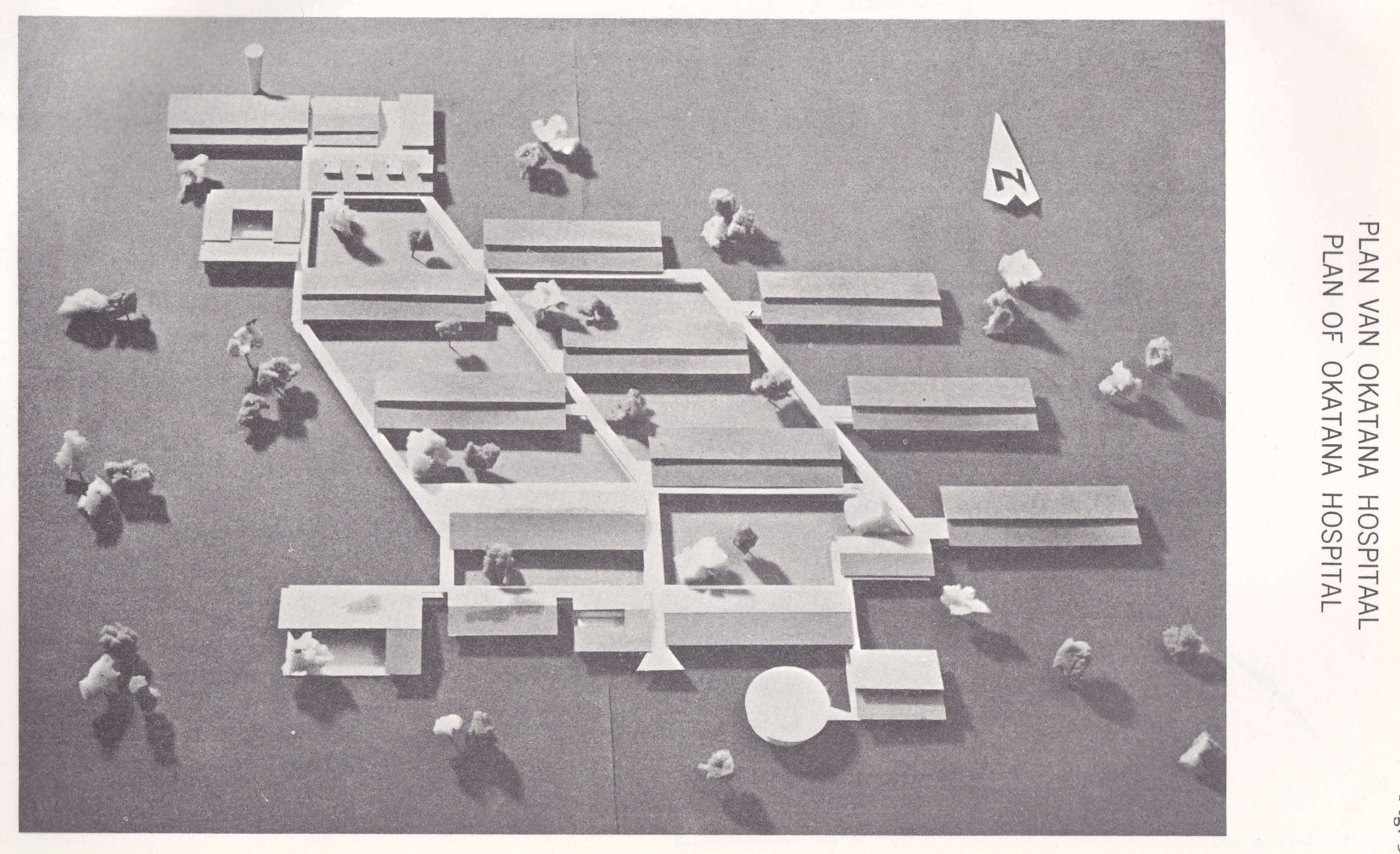
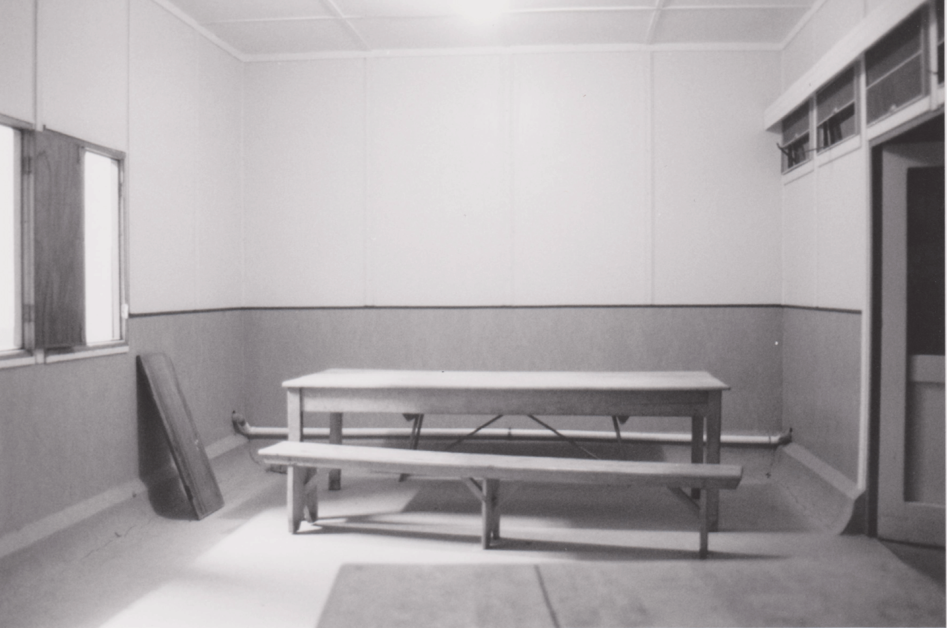
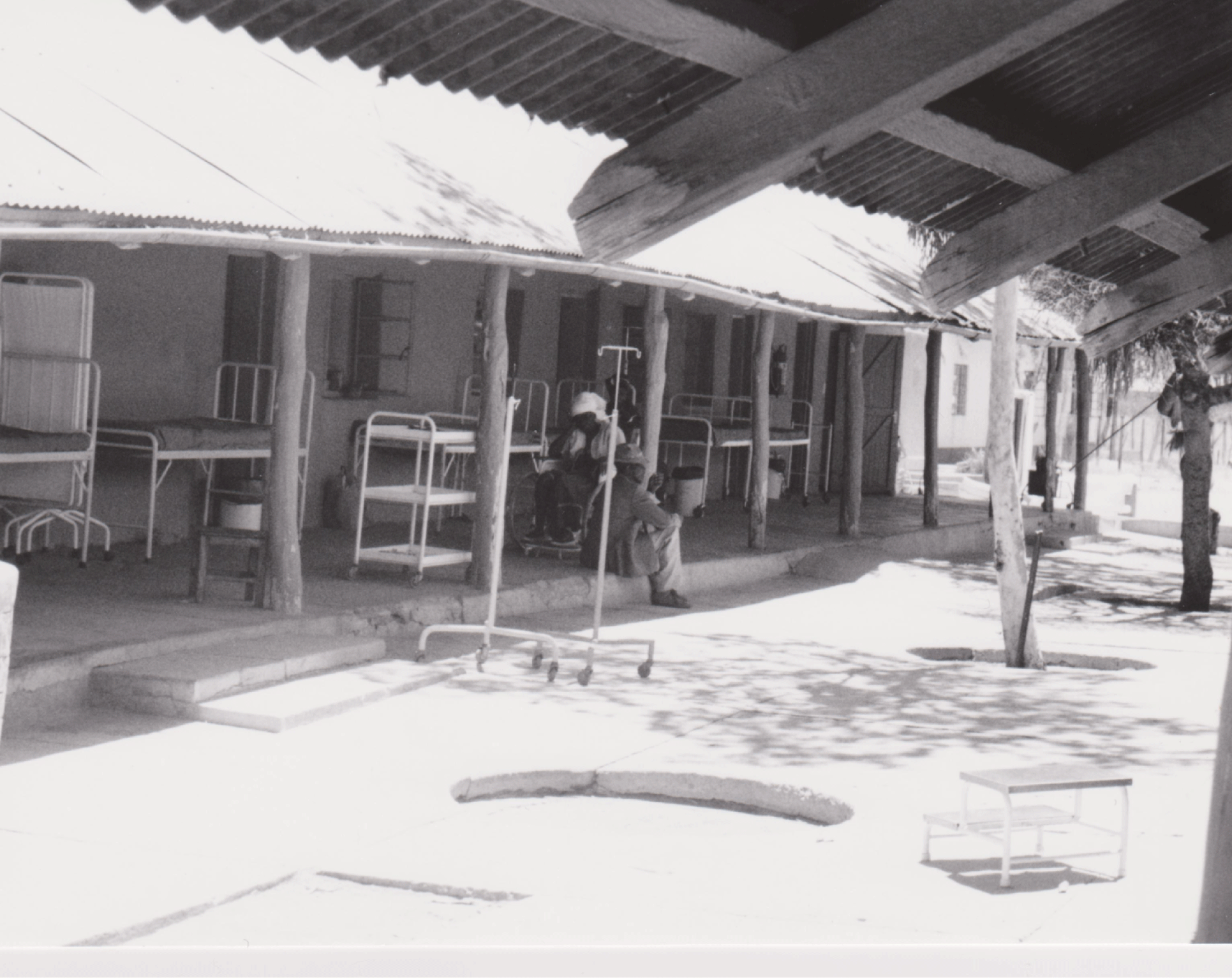
The buildings were robust and rough, both the exteriors as well as the interiors. A simple corridor ran through the greyish inpatient wards. Meals were served in the dining-hall on sturdy tables to patients who sat on benches made of wood (Figure 7).Footnote 71 Covered walkways connected the wards and protected patients and staff from the harsh climate, sun and sand (Figure 8).Footnote 72
Dining-hall with sturdy furniture in an inpatient ward in Oshakati hospital. Photo: The author, 2000.
The covered walkways connecting the wards in Oshakati hospital. Young patients from the ophthalmology clinic. Photo: The author, 2000.
European ward block in Oshakati hospital. Drawing ‘Okatana hospital, Ovamboland, Plan of European ward block’. Source: Drawing Archive in Ministry of Works, Transport and Communication.
The apartheid ideology was visible in the design of the hospital. White patients were offered a substantially higher standard than blacks, with a special inpatient ward with four private en-suite rooms with patios and baths, and a delivery ward (Figure 9).Footnote 73
The initial planning also revealed other biased allocations of resources based on race. The water supply had to be rationed. This was done according to the apartheid logic. Whites’ consumption of water for cooking and drinking was estimated to be twice as high as that of the blacks. A black patient was allocated 17.5 gallons of water daily, whereas a white family of four were allocated 150 gallons in total. Whites were expected to take daily baths while blacks were not expected to take any baths at all, just occasional showers.Footnote 74
Staff accommodation was subject to similar considerations. Accommodation needs for various staff categories, ‘European’ as well as ‘non-European’, had already been estimated in 1962,Footnote 75 but the estimation was too low. When the hospital was finished, more accommodation had to be added.Footnote 76 The quality of accommodation for the various types of staff reflected both their respective place in the hospital staff hierarchies, as well as the colour of their skin. White doctors and non-medical staff were provided with a family house or flat. Two types of accommodation for nurses were provided. ‘European sisters’ were accommodated in double-room flats with a kitchen in the patio and shared entrance and bathrooms.Footnote 77 ‘Non-European’ nurses, auxiliary nursing staff and nursing students lived in so-called single quarters.Footnote 78 White staff were also provided with a tennis court and a swimming bath.Footnote 79
The separated accommodation had a practical rationale. Black and white staff members were not allowed to socialise outside working hours. This was, however, not acceptable to all white staff. The Finnish nurses who had started working in 1966 gave their notice quite quickly when they realised that they were not allowed to speak to black colleagues or patients during their time off. They also refused to register as white nurses, as they were requested to by the local health administration.Footnote 80
Ideological and Discursive Dimensions of Healthcare
The main building of Onandjokwe hospital from 1911 and two early inpatient wards were still in use in 1997. The latter two were juxtaposed buildings with sturdy clay walls, serving as inpatient facilities with three wards for four patients each. Each building also contained two small rooms for the nurse’s station and a store located in the corner (Figure 10). The doors from the wards opened onto the veranda where patients who had chosen to stay outside were shaded by the overhanging roof, which was still supported by tree trunks (Figures 11 and 12). These two buildings were hybrids, born out of a cross-fertilisation of a European modern inpatient ward model and Ondonga architecture and building techniques. They were constructed by people who seemed to have other attitudes than those who constructed the Oshakati hospital. While the missionaries relied on local resources, the South Africans did not, except for manpower. Fifty years may separate the inceptions of the two hospitals but a decisive difference in attitudes is discernible. Where South Africans saw problems, the missionaries saw possibilities.
Sketch of the two clay inpatient wards in Onandjokwe hospital. Source: The author.
The yard between the juxtaposed inpatient ward buildings in Onandjokwe. Photo: The author, 1997.
A friend visiting a patient on the veranda in the old clay ward in Onandjokwe hospital. Photo: The author, 1997.
Missionaries have been alleged to be narrow-minded, opposing what they regarded as ‘sinful’ indigenous cultural practices, and cooperating with colonial powers. Also Finnish missionaries were a product of their time and their relationship with locals was coloured by racist mind-sets, contempt and open resistance to certain central elements in the Ovambo culture, such as the female initiation rite.Footnote 81 There were civilising ambitions embedded in the education, healthcare and religious teaching the missionaries offered to the local people in the north.Footnote 82 Medical care was a deliberately used means of attracting people to the missionary stations.Footnote 83 Hospitals are evident parts of highly visible curative care that could well have supported the conversion of local people.Footnote 84 The missionaries’ views of South Africans and apartheid were ambiguous, balanced between criticism and acceptance. Individual missionaries did not seem to agree, and the topic was subject to internal debate. Violence and abuse were not acceptable to the missionaries. Some were against apartheid, but in general they were not against separation of whites and blacks.Footnote 85 The reason for keeping a low profile regarding the South Africans was related to the South African funding of Finnish health services and the control of the missionaries’ presence in the area by the issuing of residence permits. In fact, South Africa refused to extend some of the missionaries’ visas during the 1960s.Footnote 86 Some missionaries argued that excessively strong criticism of apartheid would jeopardise their presence and consequently the Christianisation of the Ovambo people. However, no one was expelled.Footnote 87 Their concerns about the visa issue were not entirely unfounded. What they feared actually happened later in Zimbabwe where missionary health workers were forced to leave the country during the liberation war because of accusations that they had given aid to freedom fighters.Footnote 88 The South African government also seemed to have an ambivalent attitude towards the Finns since it depended on the Finnish healthcare contribution in the north, yet it had the opinion that the Finnish missionaries were meddling in Ovambo issues.Footnote 89
It is possible that the missionaries did not realise that the South Africans’ dependence on them as major healthcare providers in the north had consequences for the government’s administration. This dependence seemed to increase with intensified international criticism against apartheid since no missionary was actually asked to leave the country. The absence of missionary criticism of the homeland system seems naïve with the information they had available about South African abuse of local people. On the other hand, criticism from missionaries may not have made a great difference in practice, although it would have presented a standpoint of symbolic significance, especially for their black colleagues. There was severe tension between OPO/SWAPO and the missionaries during the late 1950s and early 1960s. The Finnish missionaries were accused of being against the liberation movement.Footnote 90 The missionaries’ ambivalence may have prevented them from foreseeing what would happen in the health service area. They did not seem to recognise that a total disaster was approaching. Taking into account the small size of each homeland and the limited funds available, the provisions that were recommended in the Odendaal report were impossible to deliver. Resources continued to be disproportionally distributed between the different population groups. In 1981 the per capita expenditure for white people’s healthcare in South-West Africa was R243, while the sum spent in Ovambo was R25.Footnote 91 The homeland policy led to extreme situations in that it fragmented health services.Footnote 92 They varied in quality and accessibility in different areas. While it was impossible to get access to care in certain areas, there were excess services in other areas due to the double provision of facilities for whites and blacks. Primary care was the focus in a few homelands, while hospital-based curative care was the only option in others.Footnote 93 However, curative services provided in hospitals could do little to impact on the general health situation, which needed public health interventions rather than medical treatment of individual patients.Footnote 94 In Ovambo the curative hospital-based healthcare continued to dominate and would grow even stronger in the years to come because of the political developments that waited around the corner. This was a period when hospital-based care was called into question and it was argued that making general public health interventions was the means to come to terms with Africans’ health problems.Footnote 95 While there was a marked decline in numbers of medical staff in missions in other countries at the dawn of independence,Footnote 96 the Finnish missionaries were able to continue both their medical and evangelising endeavours in South-West Africa.
Even though they were careful in their attitudes towards South Africans, the Finnish missionaries seemed to have had the advantage of not being associated with any colonial power, whereas all other missionary societies active at the same time did have such associations to some extent.Footnote 97 Finnish missionaries worked in close cooperation with local leaders, especially with the Ondonga kings. Oniipa missionary station was located on land that the Ondonga king had provided.Footnote 98 They started early on to educate local religious leaders, which would have a decisive influence on the future relations with the liberation movement.Footnote 99
Healthcare in the Context of War
1966 was a year when many incidents occurred that had a great bearing on the future political situation in South-West Africa, particularly in the northern part. That year the first hostilities between PLANFootnote 100 guerrilla soldiers and South African police took place in Ongulumbashe, not far from the hospital. PLAN was the military wing of SWAPO. The same year, the UN General Assembly proclaimed that the South African rule by mandate of South-West Africa was terminated.Footnote 101 However, the South African government ignored this resolution.Footnote 102 Instead, South Africa reacted to the heightened activities of PLAN with a heavy armed response. From 1979 to 1988,Footnote 103 SADF was permanently present in northern South-West Africa, which turned the north into a war zone.Footnote 104 The South African focus was on Ovambo where military bases were established in a considerable number of places.Footnote 105 However, the conflict was not ‘of a conventional-warfare type (…) this was a counter-insurgency campaign which consisted of a multitude of small-scale encounters in a “combat” zone’.Footnote 106 The ‘combat zone’ included places where people lived; hence the widely dispersed nature of the hostilities had a profound and disastrous effect on civilians and their everyday lives. People were subject to violent encounters with Koevoet, the South African special military police force, who patrolled the area in heavy vehicles in search of PLAN soldiers.Footnote 107 SWAPO members were detained and thousands of people fled the country, into neighbouring countries or overseas.Footnote 108
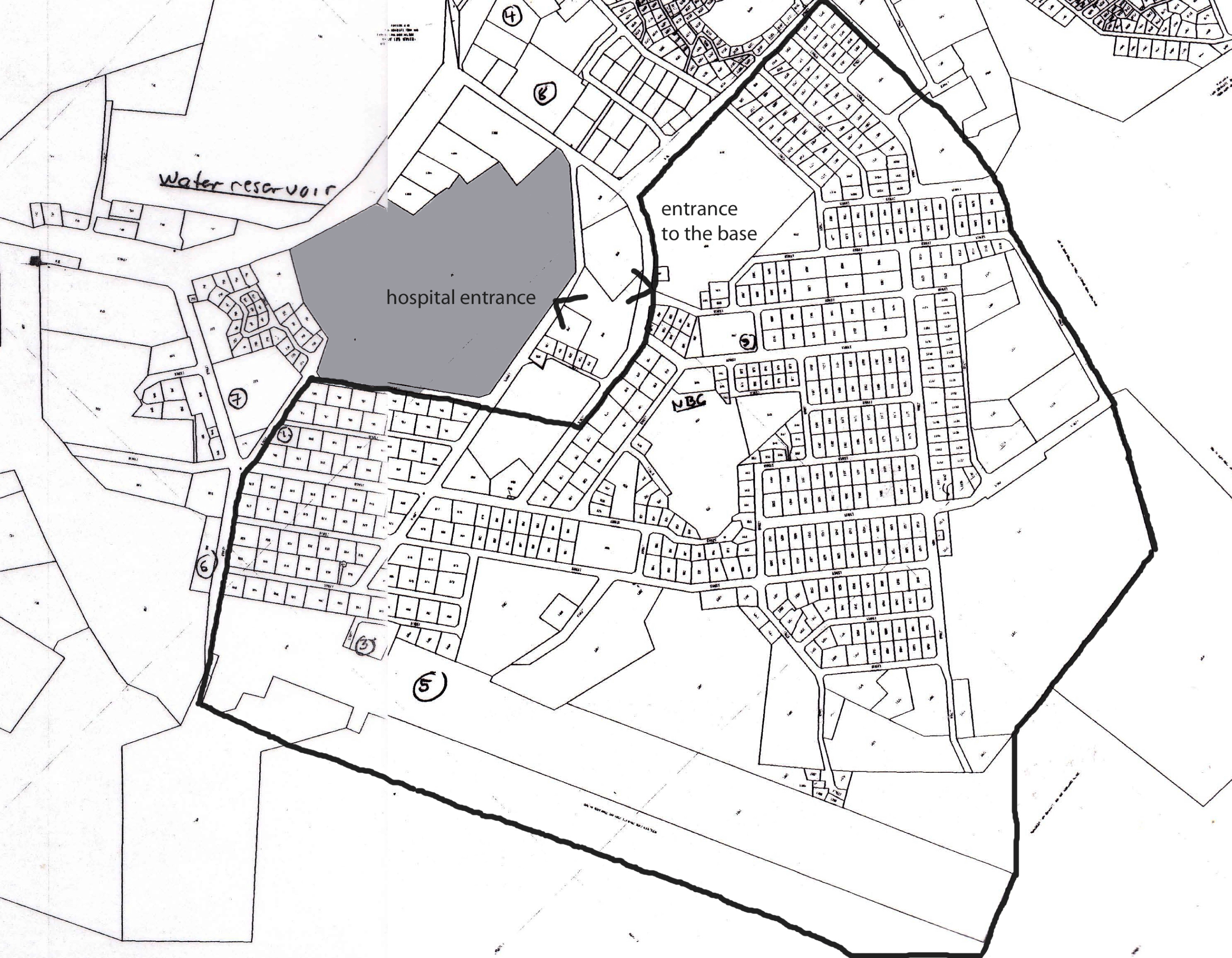
Map of Oshakati in the year 2000. The black line indicates the approximate extension of the base. The greyish area indicates the Oshakati hospital grounds. The arrows indicate the Oshakati hospital entrance and the base entrance that were just opposite each other. Reconstructed from the Structure Plan for Oshakati, General Layout Plan, Ministry of Regional and Local Government and Housing, Oshakati Town Council. Drawing no: 5370-G-01.
Militarisation of Civil Medicine
The intensification of the conflict completely changed the conditions for the hospital in Oshakati. The immediate surroundings of the hospital were fortified and fenced when a major South African base was established in the immediate vicinity. The entrance to the base was opposite the entrance to the Oshakati hospital (Figure 13). From 1982 and onwards Oshakati ‘was the most fortified town in the war-torn Ovambo (…) surrounded by watch towers, security fences and bullet-proof walls’.Footnote 109 The base included the headquarters for Sector 10 (Ovamboland), the 52 Battalion and Koevoet.Footnote 110 It was organised with military infrastructure and personnel, to cater for soldiers when they were both on and off duty.Footnote 111
A military hospital inside the base was staffed with military medical personnel at all levels, medical doctors as well as operational medical orderlies (ops medics). This was the main casualty evacuation hospital.Footnote 112 Oshakati hospital became involved in the SADF machinery. It was staffed by the military and it was used (up to 1983) by the army when X-ray examinations were needed.Footnote 113 In Oshakati hospital only five out of seventeen doctors were civilians.Footnote 114 From 1983 onwards the director of the medical services in Ovambo was a SADF colonel.Footnote 115 This was part of the SADF medical department, the South African Medical Services, headed by a Surgeon General.Footnote 116 Boundaries between civil healthcare and warfare evidently became blurred. The daily tasks in the hospitals changed due to the hostilities. Oshakati hospital dealt with civilian casualties. The hospital received patients who had lost arms and legs, often by landmine explosions. Some patients were people who had been beaten or shot by the South African military after being mistaken for PLAN guerrilla soldiers.Footnote 117
However, the war generated patients not only by military operations, but also by the most shameful of war activities, torture. A testimony in the Truth & Reconciliation hearings revealed that in the Koevoet detention cells in the Oshakati base a suspected PLAN soldier had had boiling water poured over his chest and genitals during interrogation. It had been discovered that he was a civilian and had no SWAPO connections at all, so the incident had to be concealed. The testifying ops medic was told to attend to this patient without telling anyone. ‘I didn’t know what to do, I was not qualified (…) I called in the help of a doctor from Oshakati Hospital (…) and told him not to tell anybody but to please deal with the patient’.Footnote 118 The Oshakati hospital, although basically a civilian hospital, was a resource in this ops medic’s world. However, the Koevoet’s murky activities defined the limits of the military/civilian cooperation. The testimony later revealed that the man was never brought to Oshakati hospital because an explanation for his condition would then have been necessary.Footnote 119
Three New Governmental Hospitals
The war made healthcare services available that had not existed before. As a matter of fact, huge resources were allocated to healthcare in the area; however, much less than the money that was spent on the war.Footnote 120 The SADF tried to influence the local inhabitants in the war zone by employing the ‘win the hearts and minds’ strategy.Footnote 121 The South African version of this strategy had the explicit aim of improving the relationship with local people by offering healthcare to them. The staffing of the Oshakati hospital with military personnel to improve the quality of medical care and access to it was one part of that strategy.Footnote 122 Another was that military medical personnel on duty were instructed to provide medical assistance to civilians in the area called Community Operations (COMOPS).Footnote 123 A third component of the strategy was the supply of medical facilities.
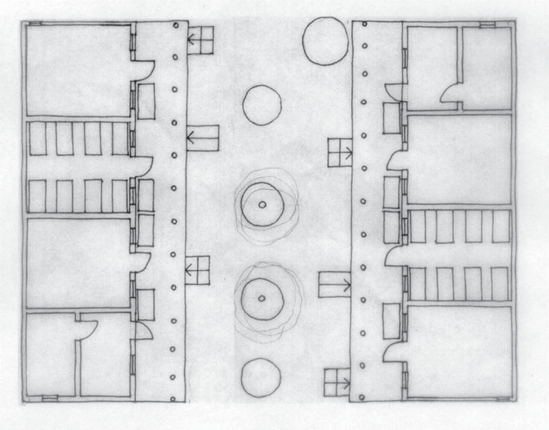
During the 1980s, Oshakati hospital was complemented by another three new governmental hospitals in Ovambo: Ombalantu (Nakanyale), Tsandi and Okahao hospitals. All three hospitals were constructed within a small geographical area at very short distances from each other. Tsandi and Okahao hospitals were about 25km apart and the hospital in Ombalantu was about 40km away from the others. This sudden generous provision in a limited area while the rest of Ovambo was still neglected was linked to the winning the hearts and mind campaign. The South Africa administration cooperated with some of the local headmen and provided them with ‘seductive donations’.Footnote 124 The hospitals were located in the respective jurisdiction areas of three Ovambo groups, Ombalantu, Uukwaluudhi and Ongandjera, with the aim of keeping local headmen satisfied and cooperative (Figure 14).Footnote 125 The three hospitals were akin to the hospital in Oshakati in type and in building techniques. All were a model type of hospital. They had similar layouts (the Tsandi and Ombalantu hospitals were identical) in which inpatient wards and other buildings were connected with a system of covered walkways. Their sizes were comparable.Footnote 126 Although very close to each other, they did not represent a parallel facility provision for whites only. These hospitals were for civilian use, and were intended for black patients. As a matter of fact, the nearby base and the hospital were explicitly kept apart. Despite the fact that medical staff were supposed to support local people with healthcare according to the COMOPS scheme, in this case the military doctor on duty in the base was not allowed to support the local hospital, even though it did not have a doctor and was only 1km away. This was due to an attack on the base by suspected local PLAN soldiers that had taken place.Footnote 127 Military considerations weighed heavier than local people’s healthcare needs.
Three new hospitals constructed in Tsandi, Okahao and Nakayale corresponding to the ethnic groups Uukwaluudhi, Ongandjera and Ombalantu, respectively. (The grey area is marked on the Finnish Missionary Society map of health facilities in Ovambo, Figure 5). Source: Notkola and Siiskonen, (note 18), 33.
There is another reason for the construction of the three hospitals that is linked to the missionary facilities and the PLAN soldiers assumed use of them. The hospitals may have been constructed with the aim of circumscribing the influence of the missionary facilities or even getting rid of them. The new hospitals were constructed in places where there were missionary clinics or small hospitals in operation (Figure 14). These clinics were closed down as a consequence of the construction of the new hospitals. Finnish missionaries were neither informed about the construction of the new hospitals nor asked to run them.Footnote 128 Without missionary hospitals it was anticipated that the guerrilla soldiers, who were assumed to seek treatment there, would then find themselves deprived of medical care or be forced to go to a government hospital.Footnote 129
A ‘Terrorist’ Hospital
The latter reason for the construction of the new hospitals mentioned above points to the links the South Africans saw between the missionaries and the liberation movement. The missionary work had led to the start of the Evangelical Lutheran Ovambo-Kavango Church (ELOK) in 1954. In 1963 the first bishop was elected, Leonard Auala, an Ovambo man. Under his leadership the church took a stand against the South African rule and openly criticised the conditions in Namibia.Footnote 130 ELOK took a central position among those supporting the liberation movement.Footnote 131 From the early 1970s onwards, the Finnish missionary society became unanimously and openly supportive of SWAPO.Footnote 132
Onandjokwe hospital, just like Oshakati hospital, received patients who had been involved in war-related incidents. According to staff members working there at the time, many patients who were wounded by landmine explosions, shooting or other casualties arrived in the hospital. South Africans must have drawn the conclusion that PLAN soldiers, if they could avoid it, most probably would not go to Oshakati hospital due to its proximity to the base. That seems a highly likely strategic analysis. Although most of the patients were civilians, it sometimes happened at night that the Onandjokwe hospital was approached in the dark by wounded PLAN soldiers who asked to see an Ovambo doctor who worked there. They left before dawn. The Onandjokwe hospital was labelled ‘a terrorist hospital’ by the South Africans. Occasionally the hospital was raided by SADF soldiers who entered the wards and removed bandages from patients to look for concealed weapons. They never found anything, according to interviewed staff.Footnote 133
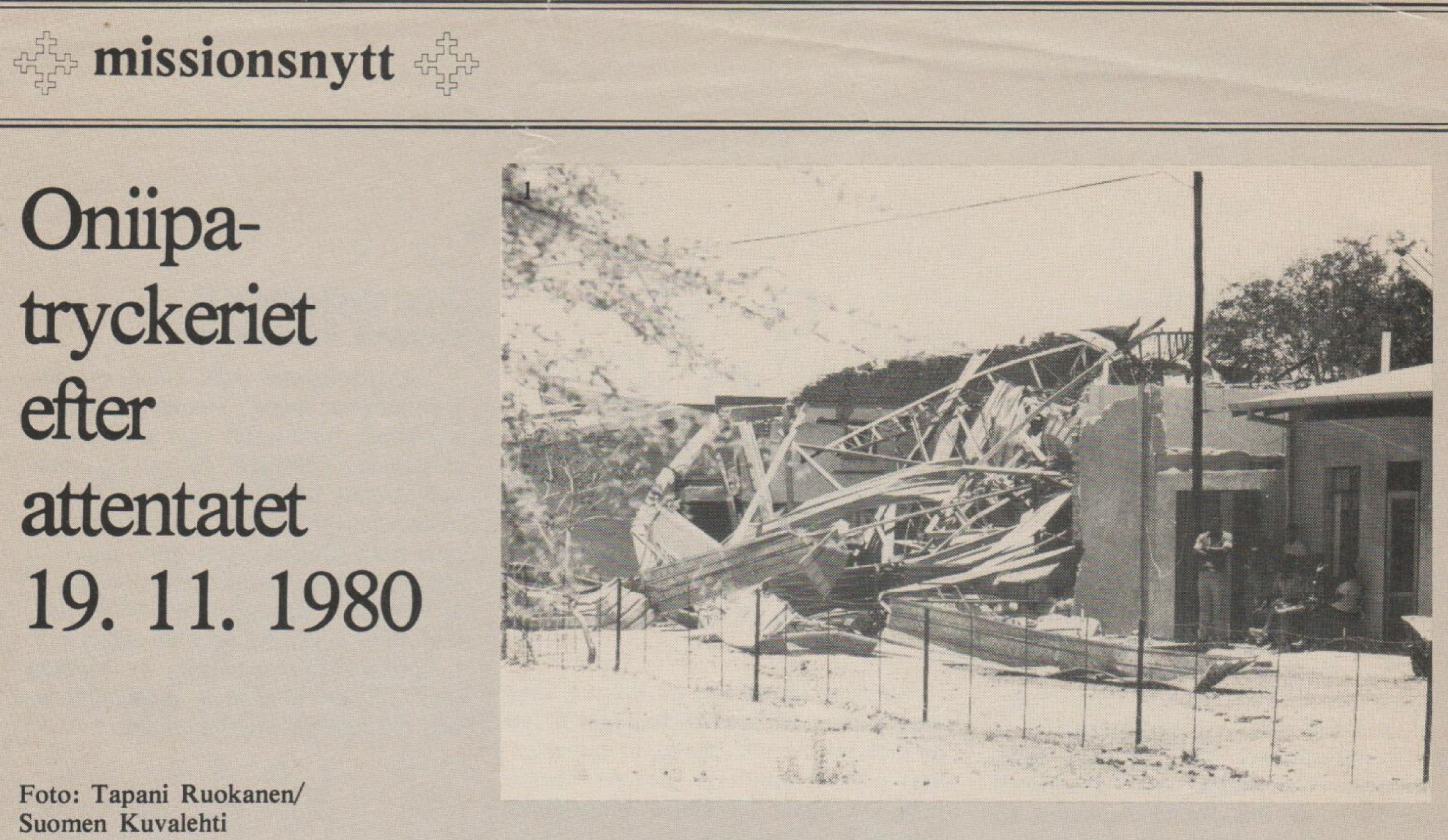
To target health facilities with violence was included in the South African strategic arsenal. The South Africans deliberately destroyed hospitals and clinics in neighbouring Mozambique, with severe consequences for local people.Footnote 134 Open protests against South Africa brought the violence closer to Onandjokwe hospital. Shortly after Bishop Auala paid a visit to the South African Prime Minister Vorster in 1973, in which he conveyed complaints about the conditions in Namibia, the ELOK’s office and printing facility in Oniipa, just outside the Onandjokwe hospital compound, was destroyed in a bomb blast (Figure 15). The printing office produced the only critical newspaper in the area.Footnote 135 The police investigation, undertaken by the South African police, never found the perpetrators.Footnote 136 This was the first time the offices were destroyed. Another blast targeted the same offices seven years later.Footnote 137 A third bomb was discovered and disarmed in the hospital in 1984. This time the missionary society openly accused the SADF military of having placed the bomb whilst conducting an inspection of the hospital.Footnote 138
The remains of the printing offices after the second bomb blast outside Onandjokwe hospital in 1980. Source: Missionsnytt, 1980 [Missionary News].
There were other, more subtle signs, suggesting that the South Africans were punishing the missionaries for their alleged cooperation with SWAPO. New staff were discouraged from working at the Onandjokwe hospital. In 1982, hundreds of patients were treated every day by only two doctors, since South African visa policies had reduced the number of Finnish staff.Footnote 139 Although the war entailed a huge increase in resources to the medical sector in Ovambo, the allocation of these resources was uneven. Onandjokwe hospital asked repeatedly for assistance in staffing, but the SADF military in charge of the local health authority refused to assist the hospital with more staff. For a year there was only one doctor on duty, who was burdened with an extreme work load.Footnote 140
Onandjokwe hospital became linked to the war and to the independence movement in the eyes of the South Africans, which made the hospital, its staff and patients, vulnerable to threats, aggression and fear. The hospital became intertwined in a highly tangible way with political aspirations that a hospital is not normally associated with. Hirst argues that war ‘often links together structures and places that seem to us to belong to very different orders’.Footnote 141 The weak boundaries between healthcare and violence that were inbuilt in the South African war apparatus, together with their inadequate regard for human rights and international agreements coalesced into a disrespect for healthcare facilities. They may have considered Onandjokwe hospital as part of the SWAPO/PLAN war infrastructure, just as Oshakati hospital was a part their own. It seems important to stress that nothing indicates that Onandjokwe hospital actually was part of a warfare organisation. The fact that wounded PLAN soldiers came for help is, in the light of international agreements, not an argument for that. The hospital served many of those who worked for a Namibian state.
Epilogue
In 1988, diplomatic endeavors put an end to the border war. The South African military quickly abandoned Ovambo after military operations came to halt. Two years later Namibia put itself on the African map as an independent state under the diplomatic leadership of the former Finnish president Martti Ahtisari. The new Namibian government took on the arduous task of renovating, refurbishing and reorganising the apartheid healthcare system they took over at independence. The new system was based on the WHO primary healthcare principle and articulated the ambition to provide ‘Health for all Namibians by the year 2000’.Footnote 142 During the first years of independence the Ministry of Health and Social Services closed down superfluous hospitals, especially those that represented the double provision based on race in the southern area. Other hospitals were renovated, reconstructed and refurbished in order to modernise existing services and create a hierarchical system of referral hospitals. Many of them were old missionary hospitals or clinics, especially in the north. A total replacement of the Engela hospital was financed by the Finnish state. The three hospitals Okahao, Tsandi and Outapi were adapted to the district level. Clinics and health centres of various sizes were provided so that all Namibians would have access to primary care within a 3-hour walking distance. Maternal and child healthcare provision had high priority.Footnote 143
In the mid-1990s, renovation works started in the Intermediate Hospital Oshakati that was to replace the whole hospital. This work was finished just over ten years later. Onandjokwe hospital was now run by the Evangelical Lutheran Church of Namibia and was also renovated.Footnote 144 It celebrated its 100-year anniversary in 2011. The adobe inpatient wards have now been torn down but the hospital will be renovated with financial support from, among others, the Finnish missionary society and the Finnish state.Footnote 145
Conclusions
In different colonies in Africa, various types of healthcare system appeared in which secular and missionary medicine cooperated and complemented each other.Footnote 146 South African and missionary interests gave shape to the healthcare distribution in the northern part of Namibia. They both had other embedded agendas besides the tangible one, the healthcare provision as such. The absence of governmental hospitals was linked to apartheid interest in that area as primarily a labour reserve. Missionaries provided the healthcare that fell outside the governmental examinations and immunisations accompanying the recruitment of contract labourers. South Africa’s neglect of local people’s healthcare needs allowed the Finnish missionaries a free hand to establish facilities according to their agenda. To them, the evangelisation was the prime goal, while healthcare was a means of attracting people to the missionary stations. Health facilities accompanied the spatial proliferation of evangelisation efforts rather than the health needs of the people. For instance, Onandjokwe hospital was constructed where the Ondonga king had allowed the missionaries to settle. However, the prospect of access to healthcare may have encouraged local leaders’ acceptance of the missionary presence.
When South Africa chose to engage directly in medical practice in Ovambo, political considerations overshadowed local health concerns. Politics and medicine were mixed in colonial practices.Footnote 147 When the apartheid hospital was constructed in Oshakati it was linked to these intertwined colonial and clandestine medico-political discourses. The healthcare provisions stipulated in the Odendaal Plan, including the construction of the Oshakati hospital, were strategic advances on an international scene. The hospital was constructed after the majority of African colonies had been given independence. An obsolete medical colonial–spatial order was maintained by the South Africans in order to save their faltering system. The unequal apartheid health system was introduced into northern Namibia by the implementation of the homeland structure, as in South Africa. At that time the Finnish missionaries tended not to criticise apartheid because of the governmental funding of the missionary healthcare system and their control of missionaries’ residence permits. This caution may have contributed to the prolongation of old-fashioned curative health services based on hospital care, even though that was not the aim. Primary healthcare was an ambition in many independent African countries and was implemented more or less successfully.Footnote 148 This was the path the government in independent Namibia followed later.
The missionaries worked according to their view of the best interests of the local people and in close cooperation with them. This interaction eventually created the final cleavage between the Finnish missionaries and the South African government. The two hospitals became involved on opposite sides in the war. They did not just receive patients produced by the war, they also became war scenes. Oshakati hospital was staffed by the military and cooperated with the neighbouring base while Onandjokwe hospital was subject to military violence and control. The international focus on Namibia probably prevented South Africa expelling Finnish missionaries and pursuing aggressive attacks on healthcare facilities as they did in newly independent Mozambique, where hospitals and clinics were the targets of the South Africans’ deliberate military assaults.Footnote 149
From the 1970s, governmental health service provisions in the north were influenced by South African military and strategic considerations. Healthcare resources were generously allocated to certain projects of strategic value to South Africa in order to win the hearts and minds of local people. Similar strategies were pursued by Portugal’s colonial administration in Guinea–Bissau where the policy of winning the hearts and minds resulted in an expansion in, among other things, the healthcare infrastructure.Footnote 150 The Finnish missionaries were redefined as the enemy in the South African ventures and were therefore excluded and disadvantaged in South Africa’s allocations of medical resources.
Medical missions and missionary stations formed part of a colonial political network that spread widely into the hinterlands of the vast colonies, constituting a vanguard in colonial expansion and biomedical medicine.Footnote 151 The Finnish missionary expansion, affected and restructured by South African apartheid and military considerations, contributed to a large extent to the future health geography of northern Namibia. Present-day hospitals and health centres in the area are located in places where the missionaries opened their hospitals and dispensaries. Many of those places are small towns or villages today. Oshakati, which did not exist before the hospital was constructed, is now the bustling centre of the region. Through Oniipa runs a long street with vendors, cuca shops,Footnote 152 markets and panel beaters’ workshops where cars and trucks stop to drop off hitchhikers at the Onandjokwe hospital.