

Introduction
On the north-west Tibetan Plateau substantial populations of the chiru or Tibetan antelope Pantholops hodgsonii, categorized as Endangered on the IUCN Red List (IUCN, 2008), and other high steppe and montane ungulates still occur and are legally protected within several recently established nature reserves. Although some of these species are abundant current changes in natural resource exploitation associated with livestock development and a nomad settlement policy, new types of hunting, and mining, are likely to have significant negative effects on their populations and long-term conservation. These changes are occurring so rapidly that it is difficult to predict their outcome but, if compared with similar changes in other dry rangeland ecosystems, consequences for the conservation of large herbivores and their predators are likely to be substantial.
Although species other than Tibetan antelope, such as the wild yak Bos grunniens and Near Threatened Tibetan argali Ovis ammon hodgsoni, are also of conservation concern because of their low numbers, other more abundant high plains species will become more vulnerable if the new land-use policies are fully applied. These species include the Near Threatened Tibetan gazelle Procapra picticaudata and Tibetan wild ass or kiang Equus kiang, which still number in the tens of thousands (Schaller, Reference Schaller1998) and are closely associated with human-livestock presence across the Chang Tang (Fox & Bårdsen, Reference Fox and Bårdsen2005). Kiangs are already receiving the brunt of criticism because of their presumed excessive forage consumption in competition with livestock, with apparent recent increases in numbers bringing bitter complaints (Authors, pers. obs.). However, as in neighbouring India (Bhatnagar et al., Reference Bhatnagar, Wangchuk, Prins, Van Wieren and Mishra2006), such perceptions must be placed in the context of both historical kiang numbers and recent human and livestock population increases. A contest between livestock industry development and wildlife conservation is just beginning, reminiscent of western North America a century ago and east Africa over the past 50 years. Issues of top-down directed modernization of Tibetan nomadic pastoralist livelihoods, disturbance of traditional accommodation between humans and wildlife, as well as commercial exploitation of wildlife resources, lie at the core of this contest.
We present a review of the current conservation situation in the remote north-west Chang Tang, based primarily on a Norwegian-funded collaboration with several educational, research, and management institutions in the Tibet Autonomous Region over the past 9 years. This work focuses on the Tibetan antelope and other large ungulates but brings to light potential consequences for many other wildlife species on the north-west Plateau (Fox & Yangzom, Reference Fox and Yangzom2005). To illustrate the overall conservation issues we concentrate here on the northern Tibet Autonomous Region Ngari Prefecture county of Gertse (135,025 km2, population 20,547 in 2006), c. 70% of which lies within the world's second largest protected area, the c. 300,000 km2 Chang Tang Nature Reserve (Fig. 1), which was created in 1993. Our work is based on 11 excursions to this region, in 1999, 2000 (two trips), 2001, 2002, 2004, 2005 (two trips), 2006 (two trips) and 2007. The focus has been primarily in and around the Aru Basin (Fig. 1), one of the best areas for wildlife within the Nature Reserve (Schaller & Gu, Reference Schaller and Binyuan1994), but in recent years it has included areas to the east across Gertse County. The research has been a combination of line-transect wildlife population surveys (Fox & Bårdsen, Reference Fox and Bårdsen2005), habitat-related studies (Dorji, Reference Dorji2006; Dunzhu, Reference Dunzhu2007; Wangdwei & Fox, Reference Wangdwei and Fox2008), investigation of traditional and modern hunting activity through interviews and surveys of drive lines and other physical signs of hunting (Fox et al., Reference Fox, Dhondup and Dorji2008; Fox & Dorji, in press), some basic anthropological investigation (Næss, Reference Næss2003), and detailed interviews with residents and government staff regarding reserve management (Yangzong, Reference Yangzong2006; Fox et al., in press). We also present some new assessments of government statistics regarding human and livestock population change, and personal income characteristics related to conservation issues, as well as new information on fencing and hunting. Our project's analyses of wildlife and human land and resource use (Yangzong, Reference Yangzong2006; Dunzhu, Reference Dunzhu2007; Wangdwei & Fox, Reference Wangdwei and Fox2008) will be important in addressing management issues in the western Chang Tang but the rapid changes in land use in the area warrant a careful summary of the conservation issues, and that is the goal of this review.
The Chang Tang Nature Reserve in the north-west Tibet Autonomous Region of China. Chang Tang refers to the northern plains of the Tibetan Plateau and connotes a region of empty wilderness. Village locations in Shenchen Township, Gertse County (see also Table 1) are numbered as follows: (1) Bakra, (2) Rexong, (3) Kangrow, (4) Margor, (5) Drabull, (6) Nagri.

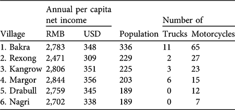
Personal income, population and number of vehicles in 2005 for the six villages in Shenchen Township, Gertse County, Ngari Prefecture (Gertse County government statistics). The numbers of each village correspond to the numbered locations in Fig. 1.
We earlier noted that if the current pattern of rangeland development for livestock seen elsewhere on the Tibetan Plateau were to be applied within the new western nature reserves the conservation outlook for wild ungulates that share the high plains grazing areas, i.e. Tibetan antelope, gazelle and kiang, would become uncertain (Fox et al., Reference Fox, Mathiesen, Yangzom, Næss and Xu2004; Fox & Tsering, Reference Fox and Tsering2005). That this policy has now been applied inside the reserves deserves both national and international attention, for there has apparently been little or no discussion or evaluation of its conservation consequences. The seemingly contradictory application of livestock management policies and conservation policies on the north-west Tibetan Plateau is likely to be a major social issue for years to come (Fox et al., in press), and conservation of the region's large mammals and other biodiversity values lies in the balance.
Recent land-use changes in Gertse County
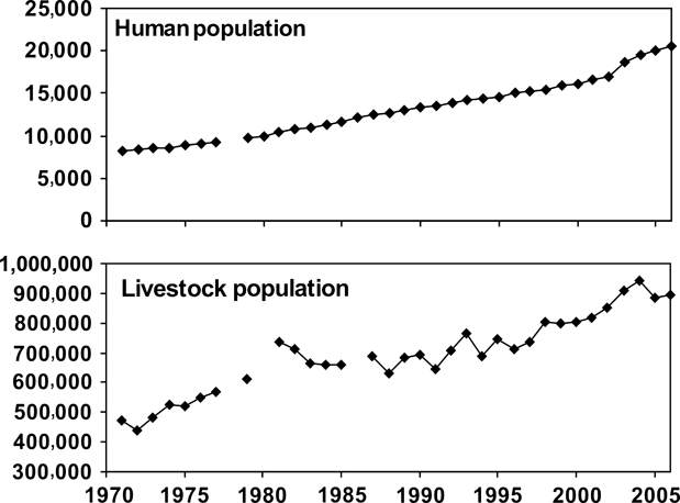
The land-use changes taking place in Gertse County are consistent with those instituted elsewhere on the rangelands of the Tibetan Plateau (Fox et al., in press); the north-west Chang Tang region is just one of the last places to receive them. The degree of human settlement is less intensive in the northern Chang Tang compared to its more southern regions (Fox et al., in press), and its history varies significantly from east to west across the Reserve (Fox & Tsering, Reference Fox and Tsering2005; Fox & Dorji, in press). Today the northern limits of human settlement across the Chang Tang Nature Reserve are at 33o–34oN (Fig. 1). Since the 1960s moderate to substantial increases in people and livestock have occurred across the northern limits of human presence within the Reserve (Fox & Tsering, Reference Fox and Tsering2005). For Gertse County, with records available from 1971, it is apparent that human and livestock populations have essentially tripled over the past 35 years (Fig. 2). Although livestock numbers have fluctuated more, primarily in association with the variable precipitation in this arid region, both people and livestock have increased by similar multiples, indicating a fairly static per capita livestock holding of c. 50 animals (primarily sheep and goats) during this period. Whether the increasing livestock densities have begun to affect rangeland quality negatively is difficult to assess. Instances of pasture degradation and associated increases in toxic plants are reported in Gertse County (Dorji, Reference Dorji2006) but large-scale documentation is lacking. There is still room for expansion of rangeland use in the region at the northern limits of habitation (currently at c. 34oN in Gertse County), and the pattern of any such expansion will become a critical issue for reserve management.
Human and livestock population trends over 1971–2006 in Gertse County, Ngari Prefecture, Tibet Autonomous Region, China.
With the recent human population increase in northern Gertse County new townships and administrative centres were established in 1999 and infrastructure (roads, houses and corrals) are being rapidly improved (Fox et al., in press). Increased construction of wells, of great benefit in improving water quality in areas already used by people, is also aiding the expansion of livestock herding to areas where surface water sources were not formerly available. In 2005 new land tenure and grazing allocation regulations were introduced to the areas of northern Gertse County inside the Nature Reserve, developments that are essentially the same as those applied throughout the rangelands of the Tibet Autonomous Region (Yangzong, Reference Yangzong2006; Fox et al., in press). The intent of local government officials is to increase livestock production both in terms of size of area and number of animals. Inside the Nature Reserve some of Gertse County's township officials speak of doubling their livestock populations to reach rangeland carrying capacity figures provided to them by Animal Husbandry Bureau workers (Fox et al., in press). Thus a complete usurpation of wildlife grazing areas by livestock may eventually occur.
Beginning in 2005 in the northern inhabited areas of Gertse County households have been allocated spatially explicit winter grazing areas. Fence construction began with initial concentration on the fencing of herding group boundaries (Plate 1a,b). Additionally, some areas are being fenced ostensibly to protect grassland from overgrazing as part of an extensive programme in western China to conserve degraded rangelands (Plate 1c,d). Gertse County's northwesternmost township, Shenchen, was directed to erect 500 km of fence line beginning in 2006 and more is planned there and in other townships (Fox et al., in press). As Plate 1 (a,c,d) illustrates, within Shenchen Township's wildlife-rich Aru Basin the fences are having direct negative consequences for the Tibetan antelope. Here, and in other northern townships of Gertse County that lie wholly within the Reserve, fences have been constructed within traditional antelope wintering areas and for many km across their migratory routes.
(a) Male antelope that died next to a c. 7 km herding group boundary fence constructed in 2007 in the Aru Basin; cause of death was unclear but two wolves were watching nearby when the animal was discovered and may have been chasing it against the fence. (b) A Tibetan wild ass or kiang that died after being caught in wires of a fence constructed in 2005 in northern Gertse County. (c) Remains of c. eight antelopes (placed on the fence wires) that apparently ran into a fence near Aru Lake; other skins may have been removed earlier (note that the fence has been knocked nearly flat). (d) Remains of a Tibetan antelope male killed in one of the new fences in the Aru Basin, this one constructed with funds allocated to western China's ‘returning pasture to grassland' rangeland conservation programme. Photos: a,c,d, JL Fox; b, T Dorji.

Although the fences present some danger to large herbivores that become entangled in the wires (Plate 1b), benefits to hunting are also becoming apparent. Herds of wild ungulates can be easily tired by chasing with motorcycles, and the new fences are being used to block their escape and make killing easier. Within the past 3 years reports have come to light of local hunting of antelopes with motorcycles in several northern townships of Gertse County, including within the Aru Basin, and similar recent incidences are known from further east in the Chang Tang (WWF China-Tibet Program, 2006). Results of such chasing, or natural occurrences of herds running into fences, are now observable inside the Reserve (Plate 1c).
Indicative of the history of hunting in the northern Gertse region, one of the County's densest arrays of traditional antelope trapping devices is within and near the Aru Basin just north of a well-known staging area for the antelope spring calving migration (Fox & Dorji, in press). The new fences are much more effective than these traditional drive-line barriers (Plate 2), and their usefulness for hunting is evident. The location of new fences across antelope migration routes in the Aru Basin (Fig. 3) clearly illustrates the potential problem with regard to both migration disruption and the use of such fencing for hunting.
The Aru Basin catchment (black boundary), with fresh water Aru Lake (lower) and salty Memar Lake (upper) dominating the Basin, and the > 6,000 m snow-capped Aru Mountains forming its western boundary. Fences constructed within the Aru Basin in 2006 and 2007 are shown as white lines or rectangles. The southern end of the basin is an important wintering and spring migration staging area for Tibetan antelope (black oval), and the antelope migration routes through the basin are shown as black arrows, with line thickness signifying relative importance. The locations of fences in Plate 1 (a,c,d) and Plate 2 are indicated. The background is from a Large Format Camera photograph taken on the Space Shuttle mission STS 41G in October 1984, courtesy of EROS/USGS.

New herding group boundary fence, intersecting a traditional hunting drive-line along an antelope migration route near the Aru Basin (Aru Mountains in background), Chang Tang Nature Reserve. Photo: JL Fox.

All antelope hunting was declared illegal at the time of the Reserve's creation in 1993 and modern weapons were confiscated from residents in c. 1995. In 2002 a nature reserve Forestry Department police official was killed by local antelope hunters from Gertse County, which acted as a flashpoint to carry out the already declared policy of confiscating all remaining traps and guns (including traditional flint-lock muskets) from the residents of the Reserve and its vicinity. Residents complain of the loss of their traditional subsistence hunting but the market for the antelope's fine wool, shahtoosh, greatly complicates this issue (Wright & Kumar, Reference Wright and Kumar1998). Antelopes are still hunted for their wool and, although some traditional trapping is still involved, modern rifles are available, sometimes supplied by illicit traders or local officials (WWF China-Tibet Program, 2006), and recently motorcycles have been used to chase down groups of animals. In 2005 three residents of northern Gertse County were caught hunting antelope with modern guns supplied by itinerant traders, and all three were imprisoned. Because the price for a good antelope skin is c. RMB 500-1,000, averaging about one third the annual per capita income in Gertse County (Table 1), the monetary lure is clear. Similar hunting incidents have recently also been reported from the eastern portion of the Reserve (WWF China-Tibet Program, 2006), indicating that hunting continues at a substantial rate throughout the southern portion of the Reserve and its vicinity, and that techniques are being modernized.
In Gertse County motorcycles are recent additions to the northern townships, first appearing in 2004–2005 (Yangzong, Reference Yangzong2006). How they are obtained, paid for, and used in this area provides a unique perspective on wildlife conservation realities in the region. Some of the northernmost villages in Gertse County are Bakra, Rexong, and Kangrow villages in Shenchen Township (Fig. 1). Although these villages have officially reported per capita earnings typical for the County, primarily from livestock products, they also have substantially more vehicles than villages immediately to the south (Table 1, Fig. 1). Bakra Village, whose grazing lands encompass a major antelope wintering area in the Aru Basin and vicinity, has by far the greatest number of these vehicles. It is well known in this area that itinerant traders from eastern Tibet now bring both guns and motorcycles to Gertse County to trade for antelope skins, and sometimes also participate in the hunting (Fox et al., Reference Fox, Dhondup and Dorji2008).
Conservation consequences for the Chang Tang
Rangeland management policy related to fencing
In other dry rangelands the effects of enclosures have been to reduce the capacity of the land to support large herbivores, both domestic and wild (Reid et al., Reference Reid, Thornton and Kruska2004). Such negative consequences have in some cases resulted in the removal of fences (Boone & Hobbs, Reference Boone and Hobbs2004). The application of rangeland enclosure to livestock management on the arid western Tibetan Plateau is therefore of dubious benefit. The potential effects of fencing on wild herbivores, especially those with disappearing long-distance migratory routes (Berger, Reference Berger2004; Wilcove, Reference Wilcove2007; Berger et al., Reference Berger, Berger, Bergen, Buuveibaatar, Fine and Lkhagvasuren2008; Bolger et al., Reference Bolger, Newmark, Morrison and Doak2008), must also be considered where conservation is a priority. Furthermore, the credibility and applicability of static carrying capacity figures to an arid rangeland that has low but highly variable annual precipitation is doubtful. But more importantly, because the current carrying capacity prescription discounts any role of wild herbivores in accessing Gertse County's grazing resources inside the area that has been designated for enhancement of biodiversity conservation, its current application is unwarranted. The policy conflict between wild herbivore conservation and livestock development is thus clear, and the impasse needs to be addressed.
If large-scale fencing continues to the point of enclosing large areas, it will detrimentally affect Tibetan antelope movement patterns and, in the end, mortality rates, in a manner similar to that which occurred with the pronghorn antelope Antilocapra americana of western North America (O'Gara & Yoakum, Reference O'Gara and Yoakum2004) and with several migratory ungulates in Africa (Boone & Hobbs, Reference Boone and Hobbs2004). Although current fencing in Gertse County does not yet present overriding obstacles to the northward migratory paths of the Tibetan antelope, if extended further it may have severe consequences for antelope as well as several other large herbivore species. Local officials are requesting the exclusion by fences of wildlife from winter grazing lands and mating areas (Fox & Tsering, Reference Fox and Tsering2005).
If the fences are used as aids in hunting, negative population effects for antelope may appear soon, although with effective hunting law enforcement this could be avoided. However, as areas become enclosed and restrict access of large herbivores to forage the effects will be longer-term and will affect species other than just Tibetan antelope. Thus, where fencing is deemed essential its construction needs nevertheless to permit wild animal movement, as it successfully does in other rangelands (Boone & Hobbs, Reference Boone and Hobbs2004). Traditional pastoralism in the Chang Tang has coexisted with abundant wildlife for centuries, and there is evidence from some arid African reserves that the removal of traditional pastoralist activity negatively affects wildlife conservation (Reid et al., Reference Reid, Thornton and Kruska2004). That such wildlife management issues were apparently not discussed prior to implementation of the carrying capacity and fencing directives for the Chang Tang Nature Reserve is a conservation management problem.
Other factors influencing wildlife conservation
Major sites of mining activity have been located in the vicinity of antelope wintering sites, spring migration staging areas, and along migration routes within the Chang Tang (Fox & Dorji, in press) and other nature reserves. Reports by local herders of hunting activity by miners suggest significant interaction between mining activity and antelope hunting. This is similar to such interaction, with loss of wildlife, reported elsewhere in western China (Harris & Loggers, Reference Harris and Loggers2004; Harris, Reference Harris2008). Gertse County received c. RMB 800,000 in tax payments from mining operations in 2004, with a substantial portion of this being distributed to local communities for development activities (Yangzong, Reference Yangzong2006). Furthermore, additional informal payments are often made to local officials. Local residents, generally not associated with employment at such sites, have voiced misgivings about both rangeland destruction and antelope hunting associated with the mining sites (pers. comms). Up to 2005, new mining operations were being opened in the northern part of the County, along or adjacent to antelope migratory routes, with construction of large dirt tracks. In 2005 a moratorium on small-scale mining in the Tibet Autonomous Region was declared, and late that year large numbers of miners were withdrawn from all of the western area, including the Chang Tang Nature Reserve. But as large-scale organized mining operations continue to be supported by government in selected areas, the scale and duration of the moratorium in the western areas is yet to be clarified, and the long-term consequences for wildlife remain to be seen.
With oil development coming to the eastern Chang Tang region (GPF, 2001), oil and mineral exploration continuing in the west, and with roads and township centres undergoing rapid improvements, it is clear that the western Chang Tang will see an increased influx of development activities in the coming years. As an example of transportation infrastructure effects in the eastern Chang Tang, the railroad-highway corridor from Qinghai to Lhasa has been shown to affect the migratory passage of an already depleted Tibetan antelope population within the Hoh-xil National Nature Reserve (Xia et al., Reference Xia, Yang, Li, Wu and Feng2007). Tourism will undoubtedly increase, and the eastern portion of the Chang Tang Nature Reserve is already being earmarked for this. Many of these developments need not negatively affect wildlife conservation, and their presence may even allow an increase of outside interest in the region that can help conservation efforts. But their effects need to be anticipated and planned for in reserve management.
Discussion
Recent wildlife surveys indicate increases in wild ungulate numbers in some areas of the Chang Tang, presumably following effective enforcement of a hunting ban initiated in the mid 1990s that targeted non-resident poachers. Recent reports by the Tibet Autonomous Region Forestry Bureau suggest that the Tibetan antelope numbers c. 150,000 in the Tibet Autonomous Region (Liu, Reference Liu2006). If correct, compared to Schaller's (Reference Schaller1998) estimate of 75,000 throughout its entire range in the early 1990s, there has either been a substantial increase or herds previously uncounted are now included. Although some increases may be real, and associated with hunting reduction, they may also be related to natural fluctuations associated with increased survival after the recent series of moist summers and snow deficient winters. Our wildlife population surveys (J.L. Fox & T. Dorji, unpubl. data) indicate (1) greater numbers of Tibetan antelope using the Aru Basin in 2000–2001 (c. 15,000) than a decade earlier (c. 5,000; Schaller, Reference Schaller1998), (2) decreasing numbers in the basin in 2000–2007, (3) apparent movement of Tibetan antelope concentrations to areas outside the Basin in recent years, and (4) substantial numbers (perhaps 25,000–30,000) across northern Gertse County. These results reveal areas with substantial, previously unreported, antelope populations to the east of the Aru Basin, and suggest significant year-to-year variability in areas of antelope concentration, a phenomenon that can be affected by human activities, as is known in other migratory species (Olson et al., Reference Olson, Mueller, Bolortsetseg, Leimgruber, Fagan and Fuller2009). As the north-west Chang Tang has not been subjected to the same intensity of poaching by non-residents as areas further east, in Qinghai for example (Harris, Reference Harris2008), there is still time to ensure the long-term maintenance of the substantial extant populations.
Although hunting remains an important conservation issue in the Chang Tang, in the long-term the extent of rangeland allocation to livestock and enclosure with fences will have the greatest influence on wild herbivore conservation in the nature reserves of the north-west Tibetan Plateau. Thus, even if present populations of antelope, kiang and other species are stable or have even increased in some areas in recent years, this should be considered with some reflection given the sweeping changes in land use that are now taking place on the Plateau. Regarding those changes consideration should be given to the fact that the maintenance of pastoralist mobility (i.e. without large-scale fencing) can be beneficial in arid rangeland ecosystem management for both domestic and wild herbivores. Effects of the new rangeland management policies on large wild herbivores have not been of great concern to date because the implementation of these policies has been in areas that had already been mostly depleted of such wildlife. On the north-west Plateau, with its still abundant wildlife, immediate consideration of wildlife needs will be essential to achieve the conservation goals embodied by the new reserves. With some of the world's last remaining long-distance migratory pathways for a large mammal still intact in the western Chang Tang, the consequences of current policies are of special concern. Without the designation of some strict conservation zones that include areas of good wintering habitat, migratory routes and calving areas, the large populations of Tibetan antelope in the north-west are likely to decline significantly and their traditional seasonal migratory patterns could eventually be lost.
Acknowledgements
We extend special thanks to the Network for University Cooperation Tibet—Norway for funding the research programme under which these field studies were carried out, and for supporting several Tibetan graduate students. Our work has been conducted under agreements with the Tibet Autonomous Region Forestry Bureau (TARFB) and in cooperation with Tibet University and the Tibet Academy of Agricultural and Animal Sciences. We would also like to thank the WWF China-Tibet Program, Lhasa Office for their cooperation during the latter phases of our work. Special thanks are also extended to Ms Drolma Yangzom at TARFB for her support of our work in the Nature Reserve.
Biographical sketches
Joseph L. Fox has focused on large mammal ecology and conservation issues in the Himalayan and Tibetan Plateau region for the past 35 years. Kelsang Dhondup uses remote sensed and field data on wildlife habitat use to address conservation issues on the Tibetan Plateau, currently through a PhD programme at the Chinese Academy of Sciences in Beijing. Tsechoe Dorji, coming from a pastoralist background on the western Tibetan Plateau, currently concentrates on plant ecology related to climate change on the Plateau through a PhD programme at the Norwegian University of Life Sciences in collaboration with Colorado State University.


