


Introduction
Humans have modified their environments to exploit resources from earliest times. Initially, this was focused on the procurement of food, clothing, shelter, and warmth. The use and control of fire was a component in the manipulation of resources, and our earliest human ancestors independently developed means of handling fire, perhaps earlier than 600,000 years ago in China (Zhong et al., Reference Zhong, Shi, Gao, Wu, Chen, Zhang, Zhang and Olsen2014). Much has been written on the course of human impacts on environmental systems. Environmental modification increased as populations expanded and the demand for resources increased correspondingly. It is likely that humans congregated in groups for the purposes of cooperation, and the invention of agriculture in all its forms led to landownership, settlements, and religious practices; the increasing technological innovations in metallurgy, pottery, crop production techniques, and animal husbandry enabled further population increases and urbanization. Procurement and exchange systems led to the impact on landscapes far away from settlements toward global networks. Very few places on Earth are now devoid of human impacts and their consequences (for general overviews, see Richardson et al., Reference Richardson, Boyd and Bettinger2001; Diamond, Reference Diamond2002; Charzan, Reference Charzan2008).
The earliest evidence of people in Jiangxi, eastern China, may have been 20,000 years ago (Cohen et al., Reference Cohen, Bar-Yosef, Wu, Patania and Goldberg2017), but the widespread effects of human impacts and landscape modification began in earnest following the development of agriculture, which was at least by 4800 cal yr BP in Jiangxi (Deng et al., Reference Deng, Yan and Yu2020). A similar history appears to apply to Hunan, where some of the world’s oldest pottery has been found (Boaretto et al., Reference Boaretto, Wu, Yuan, Bar-Yosef, Chu, Pan and Liu2009), and hunter-gatherer peoples and agriculture are known to have been present from the Early Holocene (Hung, Reference Hung, Piper, Matsumura and Bulbeck2017). Agriculture spread from a few centers with plants and animals possessing potential for high yields and nutritional values, and this spread was aided by other societies recognizing the benefits of agriculture and establishing crops and livestock well beyond their natural habitats. The rate of spread was disparate in time and space. China provides a set of circumstances that serve as an example of the spread of agriculture and landscape modification. These were driven by availability of suitable resources, climate, water, and soil. Millets were important in the northeast, rice in the central east, and early expansion of these spread around the Yellow and Yangtze Valleys. It appears that agriculture came later to the Pearl Valley, perhaps because of the availability of natural plant and animal resources there, and later still for the far northeast for political reasons. Climate change and disasters caused interruptions in some places from time to time. The records of landscape modification are evident in a variety of sedimentary records from pollen analyses, erosion histories, fossil charcoal sequences, and archaeological studies, both on land and in nearshore marine records. Such data record broad-scale regional changes (Dodson et al., Reference Dodson, Li and Song2024).
Small-scale modifications will mostly be site specific, but studies of these are few in east Asia. It seems that high mountains have some of the least disturbed sites, as they were occupied relatively late or not at all. An example of this is at Congping in Chongqing (Dodson et al., Reference Dodson, Ge, Lu and Yan2021; Chen et al., Reference Chen, Li, Zhang, Zhao, Wei, Wu, Xu and Zhao2024). Congping is relatively isolated and is mostly used by bushwalkers in summer; it is a 2–3 hour walk from the nearest village.
In the present study, we examine two records near the Hunan–Jiangxi border region of China, in the Luoxiao Mountains (Fig. 1). The ancient Tea and Salt Road passes by wetlands, which we named Zhaogongting and Jiangxi’ao. There is a published Holocene history from the Zhaogongting wetland that indicates that the Early Holocene climate (before 5400 cal yr BP) was relatively wetter than the mid-Holocene (Huang et al., Reference Huang, Zhang, Griffths, Zhao, Pausata, Tabor, Shu and Xie2023).
Location map of the study sites just inside Hunan on the border of Hunan and Jiangxi Provinces in southeastern China (a). The Tea and Salt Road is visible on the lower images (b and c). The temple is located in the cleared area, which is visible in the lower right image.

Setting
The study locations are in wet mixed deciduous/evergreen forest (Kun and Liang-Jun, Reference Kun, Liang-Jun and Box2016) at 1700 to 1790 m above sea level [m asl], close to the Hunan–Jiangxi border (Fig. 1). The Luoxiao Mountains straddle Jiangxi, Hunan, and Hubei provinces, and the ridgelines support coniferous forests of Pinus spp. and Tsuga longibrateata. There are many wetlands in the area, which are small peatlands formed on bedrock dominated by granite. The water table is maintained by small streams and natural rainfall. The two study sites (Zhaogongting and Jiangxi’ao) are bordered by species of Rhododendron, Camelia, and Salix as a shrubland, and the wetland surfaces contain a mosaic of sedges, grasses, Sphagnum and other mosses, and invading shrub species, especially members of the Rosaceae and Asteraceae families. Figure 2 shows an overview of the wetland and forest on the ridgelines at Zhaogongting.
Photograph of the Zhaogongting study site showing an overview of the wetland and forested ridgelines. Shrubs, mosses, and herbs dominate the wetland surface.

The climate is dominated by monsoon rainfall, which is principally derived from the South China Sea. The nearest meteorological stations, which are located at Hengyang and Yanling (Hunan), record that most rainfall occurs between May and August. Those stations are at much lower elevations (60 m and 220 m asl, respectively) and the rainfall amount will be much lower than for the mountains, but the seasonality is likely to be the same.
The study sites are located near the Tea and Salt Road and the Zhaogongting Temple complex. The Tea and Salt Road links Hunan with the coast and is composed of about 100 million flagstones. It is more than 150 km long and traverses lowlands and mountains above 1000 m (Chen Reference Chen2024). The temple and Tea and Salt Road are quite isolated from main areas of human habitation. The temple complex consists of several buildings, including an original Qing dynasty building and several modern buildings constructed in the last few decades. There are remains of building materials surplus to building construction and some earthworks associated with water supply from a local creek and drainage management.
There are no independent published records on the Zhaogongting Temple area, and the following was provided by Yizhi Wang, an authority of the local Suichuan County Council. The first people in the Luoxiao Shan area are believed to be refugees who immigrated from the central plains of modern-day Henan. They were looking for security and defense from war in late Tang and early Song dynasty times, estimated at about 1000 CE. The first temple was built in 1665 CE during the Qing dynasty; hence, it seems that people were in the general region long before the first temple was constructed. It is not known if local timber was used, as seems likely, but in any case, some clearing was required to provide a road and then platform for the temple complex. It is claimed that the areas with Rhododendron are largely intact and thus represent undisturbed vegetation; Rhododendron is often abundant, as at Zhoagongting, and sometimes dominant at these kinds of elevations in central China. The abundance of pristine communities of bryophytes across the sites’ surfaces also indicate minimal site disturbance. The Tea and Salt Road was established between 1663 and 1665, in the early Qing dynasty, to foster trade between Hunan, Jiangxi, and Guangdong. It was initially a muddy path over the mountains, but a wealthy businessman named Qichang Cheng donated money to upgrade it to the present stone-paved road. According to one theory, the temple was built to provide a place for rest and shade for travelers on the Tea and Salt Road. An alternative suggestion is that the temple was built for people who came to pray for health and wealth. According to a spirit tablet, it may have been built for Zhaogongming, the god of wealth, to bless and bring prosperity to merchants who passed by.
At Zhaogongting, at the end of a challenging road, the temple (at 1790 m asl) is isolated from any other human disturbances, which are far in the valleys below. The area is usually unoccupied and sees few visitors because of the state of the access road. The Zhaogongting wetland is located about 300 m slightly downslope from the temple. The Jiangxi’ao site is located near the Tea and Salt Road and is only accessible via a 3 hour walk from the nearest village. It is about 2.3 km NW of the temple (Fig. 1). The two wetlands thus provide an opportunity to assess whether this isolation from human interference can nevertheless be detected in signatures in the sediments, and the aim of the study was to obtain two Late Holocene records that span about 1000–2000 years to observe the patterns of recent human impact and environmental change.
Methods
Duplicate cores were collected from the Jiangxi’ao and Zhaogongting sites with the aid of a D-section corer in July 2023. The cores were wrapped on-site and transported to the core storage facility at the Xi’an Institute of Earth Environment, Chinese Academy of Sciences (IEE). Sediment sections were then scanned at 5 mm resolution with an Avaatech X-ray fluorescence (XRF) core scanner in IEE to identify the main geochemical composition components and to test for any clear interruptions to sedimentation. None of the latter were identified. The quantification of selected elements can be used to estimate weathering and erosion (and in some cases changes in provenance) (Mackereth, Reference Mackereth1966; Lowe and Walker, Reference Lowe and Walker1984; Chang et al., Reference Chang, An, Wu, Jin and Liu2013). The system works on the understanding that higher rainfall and erosion mobilise more soluble elements, such as rubidium (Rb), at higher rates than less soluble ones, like strontium (Sr).
Cores were subsampled for radiocarbon dating on bulk sediment to establish a chronology and then subsampled into 1 cm slices for longer-term storage. Pollen analysis was used to identify vegetation changes. For this analysis, 1 cm3 samples, at 2 cm depth intervals, were dispersed in deionised water, and a tablet of Lycopodium spores (Batch 8267, mean of 27,637 spores per tablet) was added to each to enable later estimation of pollen, spore, and charcoal concentrations to be made. Pollen sums were based on total terrestrial pollen. Charcoal concentrations were measured to reconstruct fire histories at the sites and region. The values were converted to influx rates. Samples were treated with standard pollen preparation procedures by being boiled for 10 minutes in 10% NaOH, and then sieved through a 120 µm mesh to remove large particles. They were then subjected to an acetolysis treatment, washed in deionized water (three times), and mounted on microscope slides for identification and counting. The procedures are as described in Moore et al. (Reference Moore, Webb and Collison1991), and point counts were used to estimate microscopic charcoal abundance (Clark, Reference Clark1982). The pollen diagrams (presented later) are divided into zones with the aid of a least-squares approach (Grimm, Reference Grimm1987). Samples from selected depths were submitted to the Xi’an Accelerator Mass Spectrometry Centre for radiocarbon dating and were converted to calendar ages using curves in Heaton et al. (Reference Heaton, Blaauw, Blackwell, Bronk Ramsay, Reimer and Scott2020) and Bayesian statistics to generate age models from the radiocarbon dates of the two profiles. The Bayesian statistics were run on a computer program in the Xi’an Accelerator Mass Spectrometry Laboratory.
Results
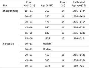
The sediment sections consisted of about 8 cm of living and partially decomposed moss (mostly Sphagnum), then dark brown peat until the base of the cores in sandy peat, at about 80–90 cm depth in both cases. The aim was to obtain records spanning about 1000–2000 years to test for evidence of human impacts and recent environmental changes. The radiocarbon results are shown in Table 1, and Figures 3 and 4 show depth and age models for the two sites using calendar ages for the cores. The age uncertainties of the radiocarbon determinations are about 30 years (2 SD), which makes precise relationships of the sedimentary changes and the historical record challenging, especially when one considers that historical changes may have a further delay before they are intense enough to be recorded in the sedimentary record. Thus, a conservative approach is used hereafter, with the calendar ages rounded to the nearest century.
Estimated calendar age–depth model profile from Zhaogongting wetland.

Estimated calendar age–depth model profile from Jiangxi’ao wetland.

Radiocarbon results. Radiocarbon results for cores collected at Zhaogongting and Jiangx’ao near the Hunan and Jiangxi border.

The XRF values were plotted as abundance of iron (Fe) and the ratio of Rb/Sr to obtain two independent estimates of erosion history for each core. This is a common procedure for lake and peat sequences (e.g., Mackereth, Reference Mackereth1966). The curves for each of these is shown in Figure 5. The Fe, Rb, and Sr are leached out of the surrounding geology and soils and accumulate in the peatland deposits. Heavy rainfall and soil erosion are the major controls of the leaching rates. Rb behaves chemically like potassium (K), while Sr has behavior similar to calcium (Ca). Rb is much more mobile in solution, and its increase relative to Sr is an indication of more intense erosion and or rainfall. The input of Fe is also a function of erosion, and because the source is slightly different, it provides a measure independent of Rb and Sr.
Zhaogongting
This site is located about 300 m from the temple and is accessed by a pathway that is part of the Tea and Salt Road. The XRF analysis for this site shows relatively low erosion values until about 1200 CE, then about a four-fold increase in both Fe and Rb/Sr indices from this date. The Rb/Sr ratio remains relatively high and variable until about 1600 CE, then declines toward pre-1200 CE values (Fig. 5). Fe values remain high, with a decline toward 1400 CE, then a rise to new peak values at about 1600 CE, and then a general decline toward the present.
Selected geochemical parameters to reconstruct landscape erosion around the Zhaogongting (ZGT) and Jiangxi’ao (JXA) wetland sites.

The pollen diagram for this site is shown in Figure 6.
Zone I (80–57.5 cm depth, estimated age 800 CE to 1100 CE): The pollen is dominated by tree taxa (50–60% of the pollen sum) with Quercus, Fagus, Carpinus, and Castanopsis/Lithocarpus the most prominent taxa. Herb taxa make up about 30–35% of the pollen sum, and fern taxa have values of about 30% (outside the pollen sum).
Zone II (57.5–28 cm depth, estimated age 1100 CE to 1460 CE): Tree taxa continue to dominate but show a decline in all major taxa, except for Salix, which has slightly elevated values, especially toward the end of the zone. Herb taxa show a gradual increase, as do fern spore values.
Zone III (28–6.57 cm depth, estimated age 1460 CE to 1850 CE): Tree taxa decline to modern values but remain dominated by Quercus, Fagus values decline, and Salix values remain relatively high. Herb and fern taxa, especially Poaceae, are increased compared with the previous zone.
Zone IV (6.5 cm to modern surface, estimated age 1850 CE to present): Tree taxa are similar to the previous zone, but fern spore values become elevated as the forest opens up.
Jiangxi’ao
This site in Jiangxi is about 2 km from the Zhaogongting Temple site (Fig. 1). The XRF values for Fe and Rb/Sr are shown in Figure 5. In contrast to the Zhaogongting record, the Fe values are moderately stable until about 600 CE, then there are three low points at 1250, 1600, and 1900 CE. The highest values are in the last two or three decades. The Rb/Sr ratios are variable around a mean of about 8 until about 1200 CE, then show a gradual decline until the present.
The pollen diagram (Fig. 7) has been divided into three main zones.
Pollen diagram from Zhaogongting wetland.

Pollen diagram from Jiangxi’ao wetland.

Zone I (82–57 cm depth, estimated age 310 BCE to 730 CE): The pollen record is dominated by tree taxa, mainly Quercus and Castanopsis and evergreen oaks (the latter include Cyclobalanopsis and several species of Quercus, and they have a distinct pollen morphology; Jarvis et al., Reference Jarvis, Leopold and Liu1992), and small numbers of Artemisia, Poaceae, and Trilete spores.
Zone II (57–39.5 cm depth, estimated age 730 CE to 1430 CE): Most tree taxa decline in abundance, while Poaceae, Cyperaceae, and Trilete spores increase.
Zone III (39.5 cm depth to the surface, estimated age 1430 CE to present): Tree taxa show a slight rise, mostly due to an increase in Pinus abundance. Poaceae, Cyperaceae, and Trilete spores were abundant in this zone.
Charcoal influx values for both sites are shown in Figure 8. In general, charcoal increases in both sites in the lead-up to the Qing dynasty. At Zhaogongting there is a decline at about 800 CE, then charcoal increases toward about 1200 CE. Charcoal is stable at the start of the Qing dynasty and rises again at the same time as the main tree pollen taxa decline. At Jiangxi’ao, the increase in charcoal begins at about 1200 CE.
Summary diagram showing changes in the main vegetation types, a selected erosion parameter (Rb/Sr), and charcoal influx (CHAR) for the two study sites. The timing of the Tang and Qing dynasties is also shown. (a) Rb/Sr ratio from Jiangxi’ao (JXA); (b) Rb/Sr ratio from Zhaogongting (ZGT); (c) tree and shrub pollen from Zhaogongting; (d) tree and shrub pollen from Jiangxi’ao; (e) herb pollen from Zhaogongting; (f) herb pollen from Jiangxi’ao; (g) charcoal influx from Zhaogongting, and (h) charcoal influx from Jiangxi’ao.

Discussion
Analyses of Zhaogongting and Jiangxi’ao wetland sediments and comparison with historical information yield a detailed reconstruction of local and regional landscapes over the last millennium and help derive a detailed reconstruction of local and regional landscapes, including patterns of vegetation, erosion, and fire. Figure 8 summarizes the main changes in these elements and shows the timing of the Tang and Qing dynasty periods. The small size of the basins and dense vegetation cover surrounding both study sites likely result in most of the sedimentary record being dominated by local factors, although there may be a regional signal of pollen and charcoal. The advantage of having records from two sites, just 2 km apart, is that we can discern local and, where common in time, regional environmental changes.
The erosion indices reflect both heavy rainfall and soil disturbance due to human impacts. The most substantial change is recorded for the Zhaogongting wetland at around 1200 CE. This is not evident at Jiangxi’ao, where, in fact, erosion rates appear to be declining at that time, so we assume the change at Zhaogongting is a local response that may be related to human activity. The Zhaogongting response predates the construction of the temple by several hundred years, yet suggests that there was some human activity near the site at the time, perhaps even on the flat platform where the temple was later constructed. Fe values are high again around 1500–1600 CE and may be related to construction of the Tea and Salt Road and temple, although those activities occurred 100 years later according to the historical record. Both sites show a steady decline in Rb/Sr values; this may be a reflection of increasing vegetation cover and relatively rapid organic matter production diluting the erosion signature that the ratio represents. The variations in Fe values at Jiangxi’ao are presumably due to local factors, as they are not evident at Zhaogongting. The peak in Fe values is dated to around 1500–1600 CE at both sites and may be due to areas of erosion caused by the construction of the Tea and Salt Road.
The presence of charcoal indicates fire, and variations in charcoal may reflect changes in fuel loads and/or ignition sources locally or regionally. The wet forests and high rainfall would be expected to limit the natural occurrence of fire; however, the substantial amount of human activity at the study sites suggests that human-set fire is a major component in the charcoal data. The records of fire at the two sites show a broad similarity, with low values near the base of the records, then increasing and declining fire during the Qing period, before increasing again from the beginning of the twentieth century. The general similarity of the charcoal curves suggests that the fire record is largely a regional one.
At Zhaogongting, the first presumed local fires begin around 1200–1400 CE (Fig. 8), followed by a recent increase in fires from about 1800 CE. At Jiangxi’ao, there seems to be a period of fire at about 800 CE, and a further rise from about 1000 CE(Fig. 8), a steady occurrence of fire until about 1800 CE. The two fire records are generally asynchronous until the twentieth century. The palaeoecological data indicate there is a clear record of human impact that precedes the building of the temple and the establishment of the Tea and Salt Road. These data, along with the erosion history records, suggest that people were in the area before the temple and road were built and that this is plausible, given that the first substantive regional migrations occurred in the Tang and Song dynastic periods.
The decline in major tree taxa and expansion of grasses and ferns appears at about 1500 CE for both sites and likely represents a regional trend, probably as more land was opened in the lowlands around Luoxiao Shan for agriculture.
The site erosion and fire histories of the sites are mutually independent before evidence of human impact. Thus, the records suggest there was some human environmental impact 500 or more years before the temple and Tea and Salt Road were established. It may have been the presence of people from Tang dynasty times that drew the attention to the area and later led to the establishment of both the temple and the Tea and Salt Road. Once the temple was established, it would be expected that the number of people present, such as travelers along the Tea and Salt Road, greatly expanded.
Widespread regional human impacts in eastern China, especially close to the Yangtze, probably began from about 5000 years ago (see Dodson et al. [Reference Dodson, Li and Song2024], which includes a review of regional trends). No local sites near the study area have been examined to test for human impact as early as this, although they are likely in the fertile lowlands surrounding the Luoxiao Mountains. A number of studies are emerging that demonstrate human impacts in lowland areas precede those in mountain areas by some millennia, although humans were often absent from mountainous terrain (e.g., Dodson et al., Reference Dodson, Ge, Lu and Yan2021, Reference Dodson, Li and Song2024; Feng et al., Reference Feng, Huang, Ma, Cheng, Meadows and Lu2024). For the study sites, human impact was late and well within the historical period.
Conclusions
During the mid-seventeenth century Qing dynasty, a temple complex and a Tea and Salt trade road were constructed near the study sites. This study compares palaeoecological data with the historical record and is able to tease out local- and regional-scale landscape changes. The two lines of evidence combine to give a more complete view of environmental changes and the scale of human impact. The synthesis of both lines of evidence provides insights into the spatiotemporal patterns of human environmental impacts, such as earlier human impacts in lowlands than in mountainous areas.
Acknowledgments
We thank Chengde Liang, Kaiyu Yang, Guozhen Wang and Xiaoqing Rong for assistance in the field. We also thank Yizhi Wang of the Suichuan County Council, Jiangxi, for his generous provision of material on the history of the area. Importantly, we wish to acknowledge the editors, who went beyond the call of duty to improve the final form of the article.
Funding
This work was supported by the Strategic Priority Research Program of Chinese Academy of Sciences (XDB40000000) and the National Natural Science Foundation of China (NSFC) (42077413).
Competing Interests
The authors declare they have no conflicts of interest.


 Open access