


Introduction
Fluvial systems occupy a key position in paleoenvironmental research, providing important archives of environmental and geomorphic changes, especially during the late Pleistocene and Holocene (e.g., Arbogast et al., Reference Arbogast, Bookout, Schrotenboer, Lansdale, Rust and Bato2008; Zielhofer et al., Reference Zielhofer, Faust and Linstädter2008; Kirchner et al., Reference Kirchner, Nehren, Behling and Heinrich2015, Reference Kirchner, Karaschewski, Schulte, Wunderlich and Lauer2022; von Suchodoletz et al., Reference von Suchodoletz, Menz, Kühn, Sukhishvili and Faust2015; Depreux et al., Reference Depreux, Lefèvre, Berger, Segaoui, Boudad, El Harradji, Degeai and Limondin-Lozouet2021). In the last century, global climatic changes and increased human pressure on fluvial systems and their catchments have spurred interest in understanding the long-term dynamics of fluvial systems, particularly during the late Pleistocene and the Holocene. These time periods are critical and of significant interest, as they marked a transition from the cold conditions of the last ice age to the warmer conditions of the Holocene, which was characterized by significant changes such as glacial retreats, hydro-climatic and environmental shifts, and changing sedimentation conditions (Lowe and Walker, Reference Lowe and Walker2014; Druzhinina et al., Reference Druzhinina, Kublitskiy, Stančikaitė, Nazarova, Syrykh, Gedminienė and Uogintas2020). Moreover, human activities such as agriculture, industrialization, and settlement expansion had a significant impact on the environment and landscapes during these phases (Kalis et al., Reference Kalis, Merkt and Wunderlich2003; Lang et al., Reference Lang, Bork, Mäckel, Preston, Wunderlich and Dikau2003; Houben et al., Reference Houben, Hoffmann, Zimmermann and Dikau2006; Mäckel et al., Reference Mäckel, Friedmann and Sudhaus2009).
The Rhine fluvial hydrosystem in northwest Europe, like many other fluvial systems in the northern temperate zone, underwent a series of adaptive modifications in its functioning and morphodynamics in response to late Pleistocene and Holocene climate and environmental changes (Berendsen et al., Reference Berendsen, Hoek and Schorn1995; Dambeck and Thiemeyer, Reference Dambeck and Thiemeyer2002; Schirmer et al., Reference Schirmer, Bos, Dambeck, Hinderer, Preston, Schulte, Schwalb and Wessels2005; Bos et al., Reference Bos, Dambeck, Kalis, Schweizer and Thiemeyer2008; Erkens et al., Reference Erkens, Hoffmann, Gerlach and Klostermann2011; Schmitt et al., Reference Schmitt, Houssier, Martin, Beiner, Skupinski, Boës and Schwartz2016). Thus, the Rhine system has been the subject of extensive research to comprehend the interplay between natural and anthropogenic factors and their impact on the long- and short-term evolution of fluvial systems and their associated landscapes (e.g., Törnqvist, Reference Törnqvist1994, Reference Törnqvist1998; Stouthamer and Berendsen, Reference Stouthamer and Berendsen2000; Dambeck and Thiemeyer, Reference Dambeck and Thiemeyer2002; Lang et al., Reference Lang, Bork, Mäckel, Preston, Wunderlich and Dikau2003; Kasse et al., Reference Kasse, Hoek, Bohncke, Konert, Weijers, Cassee and Van Der Zee2005; Houben et al., Reference Houben, Hoffmann, Zimmermann and Dikau2006; Erkens et al. Reference Erkens, Dambeck, Volleberg, Bouman, Bos, Cohen, Wallinga and Hoek2009, Reference Erkens, Hoffmann, Gerlach and Klostermann2011; Lämmermann-Barthel et al., Reference Lämmermann-Barthel, Neeb, Hinderer and Frechen2009; Schmitt et al., Reference Schmitt, Houssier, Martin, Beiner, Skupinski, Boës and Schwartz2016). However, despite this body of research, relatively few studies have focused on understanding the long-term fluvial evolution of the Upper Rhine alluvial plain, a densely populated section along the Rhine between Basel (Switzerland) and Bingen (Germany; Fig. 1).
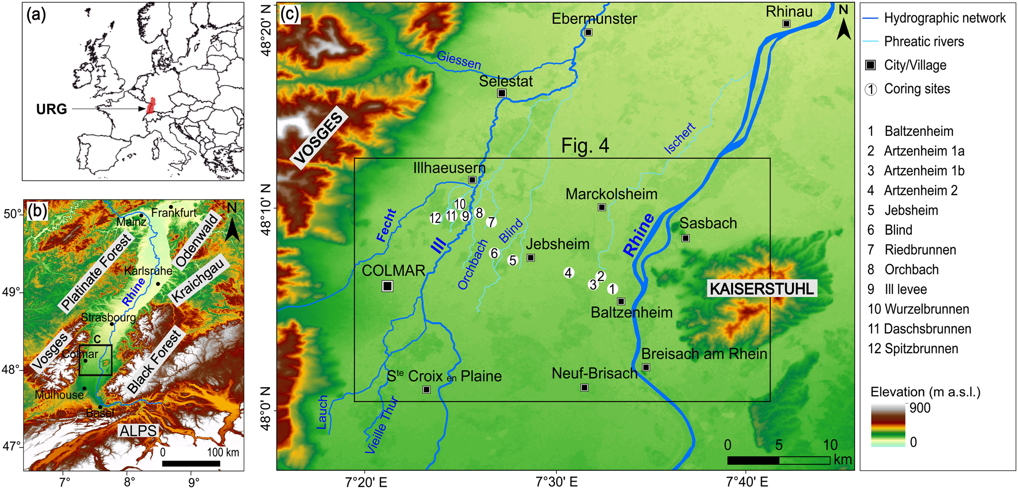
Overview of the study area. (a) Location map of the Upper Rhine Graben (URG) in Europe. (b) Location of the study area within the URG. (c) The investigation area (framed by the black box) within the French Rhine alluvial plain showing the locations of coring sites. Source of digital elevation data: CGIAR-CSI (n.d., https://srtm.csi.cgiar.org/srtmdata).
While some studies have been undertaken in the northern reaches of the Upper Rhine plain, between Karlsruhe and Mainz (e.g., Dambeck and Thiemeyer, Reference Dambeck and Thiemeyer2002; Bos et al., Reference Bos, Dambeck, Kalis, Schweizer and Thiemeyer2008; Erkens et al., Reference Erkens, Dambeck, Volleberg, Bouman, Bos, Cohen, Wallinga and Hoek2009, Reference Erkens, Hoffmann, Gerlach and Klostermann2011; Fig. 1), studies of comparable scope in the southern and central parts of the plain, between Basel and Karlsruhe, are relatively scarce, with only a few exceptions (e.g., Carbiener, Reference Carbiener1969; Al Siddik, Reference Al Siddik1986; Hirth, Reference Hirth1971; Schmitt et al., Reference Schmitt, Houssier, Martin, Beiner, Skupinski, Boës and Schwartz2016). Most studies conducted in this part of the Upper Rhine plain have focused on the historical fluvial dynamics or have been restricted to specific aspects such as neotectonics, historical flooding patterns, or human impacts on river dynamics (e.g., Lang et al., Reference Lang, Bork, Mäckel, Preston, Wunderlich and Dikau2003; Ollive et al., Reference Ollive, Petit, Garcia and Reddé2006; Boës et al., Reference Boës, Schmitt, Schwartz, Gebhardt, Goepp, Lasserre, Barral, Daubigney, Dunning, Kaenel and Roulière-Lambert2007; Lämmermann Barthel et al., Reference Lämmermann-Barthel, Neeb, Hinderer and Frechen2009; Mäckel et al., Reference Mäckel, Friedmann and Sudhaus2009; Eschbach et al., Reference Eschbach, Schmitt, Imfeld, May, Payraudeau, Preusser, Trauerstein and Skupinski2018). Few paleoenvironmental studies have been conducted in recent years to gain a deeper understanding of the Holocene evolution of the Upper Rhine fluvial hydrosystem, with a particular focus on the Ried Central d'Alsace region (located between Colmar and Strasbourg) within the French Upper Rhine plain (e.g., Boës et al., Reference Boës, Schmitt, Schwartz, Gebhardt, Goepp, Lasserre, Barral, Daubigney, Dunning, Kaenel and Roulière-Lambert2007; Schmitt et al., Reference Schmitt, Houssier, Martin, Beiner, Skupinski, Boës and Schwartz2016; Chapkanski et al., Reference Chapkanski, Ertlen, Rambeau and Schmitt2020; Abdulkarim et al., Reference Abdulkarim, Chapkanski, Ertlen, Mahmood, Obioha, Preusser, Rambeau, Salomon, Schiemann and Schmitt2022). This area is an extensive and exceptionally biodiverse alluvial landscape (Carbiener, Reference Carbiener1983a, Reference Carbiener1983b) that features a remarkably well-preserved and complex network of paleochannels, providing an ideal and regionally significant fluvial archive for deciphering the long-term fluvial dynamics and evolution of the southern and central parts of Upper Rhine plain.
Preliminary studies indicate the presence of at least five major paleochannel systems in the region, with considerable differences in their surface topographic features, geometry and architecture, and provenance of infill sediments (Abdulkarim et al., Reference Abdulkarim, Chapkanski, Ertlen, Mahmood, Obioha, Preusser, Rambeau, Salomon, Schiemann and Schmitt2022). These differences in geomorphic features and sediment provenance are linked to significant shifts in hydro-geomorphological processes in the area, as well as lateral movements of the Rhine and Ill Rivers (the latter is a major tributary of the Rhine in the region; Fig. 1), which are believed to have persisted since at least the Early Holocene (e.g., Schmitt et al., Reference Schmitt, Houssier, Martin, Beiner, Skupinski, Boës and Schwartz2016; Abdulkarim et al., Reference Abdulkarim, Chapkanski, Ertlen, Mahmood, Obioha, Preusser, Rambeau, Salomon, Schiemann and Schmitt2022). However, these previous studies primarily relied on remote sensing data, hand-augured core sediment profiles, and very few radiocarbon ages. As a result, the sedimentological characteristics of the paleochannel systems remain poorly understood, and there are still significant ambiguities regarding the rivers’ evolutionary trajectories and lateral shifting patterns, as well as the timing of major shifting episodes. Moreover, the factors governing the lateral movements of rivers in the region have yet to be definitively established.
In view of this knowledge gap, the work presented here aims to reconstruct the late glacial and Holocene evolution of the fluvial hydrosystems in the Ried Central d'Alsace, particularly focusing on (1) the major fluvial system changes, especially the lateral mobility of the fluvial hydrosystems; and (2) their controlling factors. Objectives of this study are to: (1) systematically characterize the infill sediments of the paleochannels and natural levee of the Ill River using a multiproxy approach including sedimentological, geochemical, and geochronological methods; (2) accurately reconstruct the temporal trajectories of the rivers and establish a robust chronology of the fluvial system changes since the late glacial period; and (3) assess potential driving factors that controlled major fluvial system changes, lateral river movements, and subsequent paleochannel formation.
Geologic and Geomorphological Setting
The study area is located within the southern part of the Upper Rhine Graben (URG), on the French side of the Rhine alluvial plain (Fig. 1). As part of the European Cenozoic Rift System (Ziegler, Reference Ziegler1992), the URG is a rift valley measuring 300 km in length and 30–40 km in width, extending from the Jura Mountains in the south/southwest to the Rhenish Massif in the north. To the west, the URG is bordered by the Vosges Massif and Palatinate Forest, and on its eastern periphery by the Black Forest and Odenwald Mountains, which are separated by the Kraichgau depression. The graben shoulders are formed mainly of Variscian crystalline basement and Mesozoic siliciclastic and carbonate sedimentary rocks (Fig. 1). Since the beginning of the Pleistocene, the Rhine has flowed toward the North Sea through the subsiding URG basin (Preusser, Reference Preusser2008), which serves as a major sediment depocenter with accumulations reaching several hundred of meters in thickness (e.g., Haimberger et al., Reference Haimberger, Hoppe and Schäfer2005; Gabriel et al., Reference Gabriel, Ellwanger, Hoselmann, Weidenfeller and Wielandt-Schuster2013).
At the end of the late glacial, the Rhine's longitudinal profile evolved due to factors such as decreased water and sediment volume caused by warmer climatic conditions, sediment entrapment in Swiss Rhine lakes, and neotectonic movements (Schmitt et al., Reference Schmitt, Houssier, Martin, Beiner, Skupinski, Boës and Schwartz2016 and references therein). Consequently, the Upper Rhine's longitudinal profile incised in some sections during the Holocene, particularly from Basel to Neuf-Brisach and from Strasbourg to Lauterbourg, while other sections (Neuf-Brisach to Strasbourg) remained stable or slightly elevated (Carbiener, Reference Carbiener1969, Reference Carbiener1983b; Fig. 2).
(a) Postglacial and Holocene longitudinal profiles of the Upper Rhine. (b) Some Upper Rhine hydromorphological characteristics for each longitudinal sector (modified from Commission Internationale de l'Hydrologie du Bassin du Rhin, 1977; Carbiener and Dillmann, Reference Carbiener, Dillmann, Gallusser and Schenker1992; Schmitt, Reference Schmitt2001; Schmitt et al., Reference Schmitt, Beisel, Preusser, de Jong, Wantzen, Chardon, Staentzel, Hamman and Vuilleumier2019).
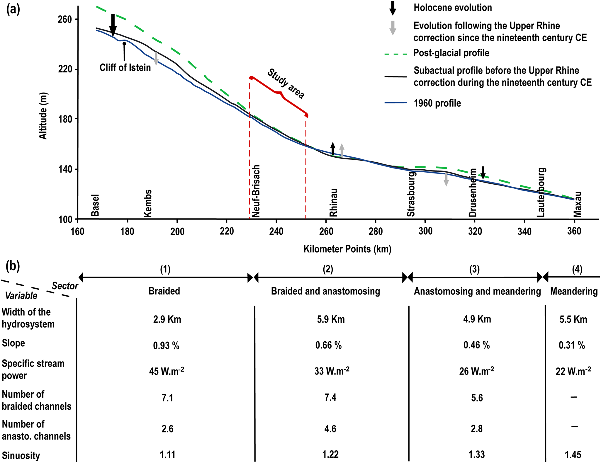
As a result, the Holocene Upper Rhine and its alluvial plain are divided into four longitudinal sectors (Fig. 2), as delineated by Carbiener (Reference Carbiener1969, Reference Carbiener1983b) and Schmitt et al. (Reference Schmitt, Houssier, Martin, Beiner, Skupinski, Boës and Schwartz2016). The upstream sector, from Basel to Neuf-Brisach, is characterized by a preponderance of braided channel patterns with some anastomosing and closed anabranching channels (Arnaud, Reference Arnaud2012; Schmitt et al., Reference Schmitt, Houssier, Martin, Beiner, Skupinski, Boës and Schwartz2016). The median sector, between Neuf-Brisach and Strasbourg, exhibits a braided-anastomosing pattern, while the downstream sector, from Strasbourg to Lauterbourg, combines anastomosing channels and incipient meanders. A dominant meandering pattern typifies the sector farther north (downstream), from Lauterbourg to Bingen. It is important to highlight that river engineering works in the nineteenth and twentieth centuries have destroyed these natural channel patterns and dynamics of the Upper Rhine (e.g., Preusser et al., Reference Preusser, May, Eschbach, Trauerstein and Schmitt2016; Eschbach et al., Reference Eschbach, Schmitt, Imfeld, May, Payraudeau, Preusser, Trauerstein and Skupinski2018).
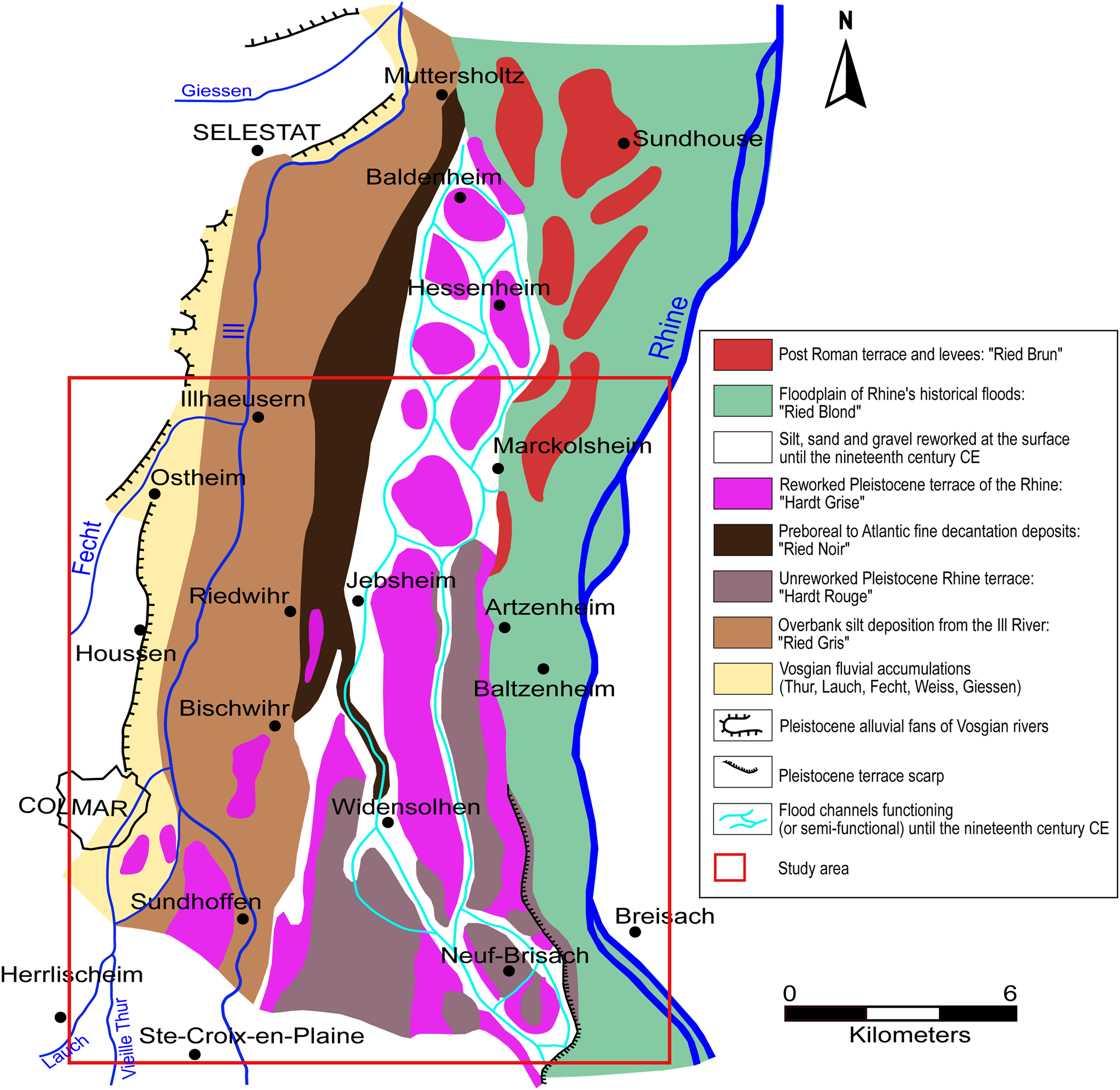
The French Rhine alluvial plain is typically divided into two distinct longitudinal geomorphic zones, the “Hardt” and the “Ried,” based on hydrological, ecological, and pedogenic differences (Carbiener, Reference Carbiener1969; Hirth, Reference Hirth1971; Kremer et al., Reference Kremer, Rieb, Rebholtz and Delecolle1978; Ollive et al., Reference Ollive, Petit, Garcia and Reddé2006; Fig. 3). The Hardt zone (corresponding mostly to the Rhine braided sector) is characterized by coarse sand and gravel islands formed as part of the Rhine River's Pleistocene alluvial terraces. This zone is further subdivided into the Hardt Rouge and Hardt Grise. The Ried area (corresponding mostly to the Rhine braided-anastomosing sector) is a low-lying, marshy landscape with hydromorphic soils, predominantly composed of mud and fine sand interspersed with organic matter (OM; Carbiener, Reference Carbiener1969, Reference Carbiener1983b; Hirth, Reference Hirth1971; Kremer et al., Reference Kremer, Rieb, Rebholtz and Delecolle1978; Ollive et al., Reference Ollive, Petit, Garcia and Reddé2006). The Ried is transversely subdivided into four sections within the alluvial plain: Ried Gris, Ried Noir, Ried Blond, and Ried Brun (Fig. 3).
Geomorphological map of a section of the French Rhine alluvial plain (Colmar-Sélestat; according to Hirth [1971], revised by Schmitt [2001] and Schmitt et al. [Reference Schmitt, Houssier, Martin, Beiner, Skupinski, Boës and Schwartz2016]), the southern portion of which constitutes our study area. Figure modified from Schmitt et al. (Reference Schmitt, Houssier, Martin, Beiner, Skupinski, Boës and Schwartz2016).
The study area is located in the valley region between Illhaeusern and Marckolsheim in the north and Neuf-Brisach and Sainte-Croix-en Plaine in the south (Figs. 1 and 3). It covers an area of approximately 572 km2 and is part of the alluvial plain's braided-anastomosing sector. The area also forms the southern portion of the Ried Central d'Alsace. The Rhine River mainly drains the area in the east and the Ill River in the west. The Fecht River, which flows into the Ill River at Illhaeusern, is a major western tributary in this region.
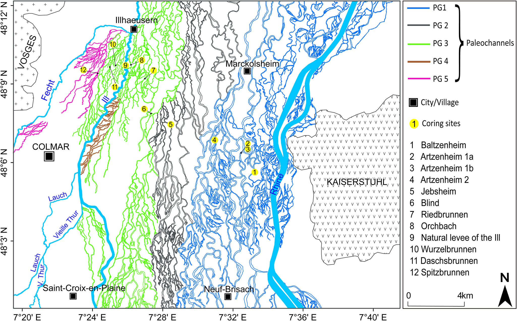
The contemporary floodplain has a distinct microtopography characterized by a dense and intricate network of paleochannels (Fig. 4) filled with a mix of clastic and organic deposits several meters thick (Schmitt et al., Reference Schmitt, Maire, Nobelis and Humbert2007, Reference Schmitt, Lafont, Trèmolières, Jezequel, Vivier, Breil, Namour, Valin and Valette2011, Reference Schmitt, Houssier, Martin, Beiner, Skupinski, Boës and Schwartz2016; Chapkanski et al., Reference Chapkanski, Ertlen, Rambeau and Schmitt2020; Abdulkarim et al., Reference Abdulkarim, Chapkanski, Ertlen, Mahmood, Obioha, Preusser, Rambeau, Salomon, Schiemann and Schmitt2022). Some of these paleochannels, however, have a current connection to groundwater or the Rhine (during floods) or the Ill River and contain phreatic and semi-phreatic rivers that are home to a diverse range of aquatic macrophytes (Carbiener, Reference Carbiener1983a, Reference Carbiener1983b; Trémolières et al., Reference Trémolières, Eglin, Roeck and Carbiener1993; Schmitt, Reference Schmitt2001; Schmitt et al., Reference Schmitt, Houssier, Martin, Beiner, Skupinski, Boës and Schwartz2016). The paleochannels show distinct differences in their surface topographic features and paleo-flow orientations (Abdulkarim et al., Reference Abdulkarim, Chapkanski, Ertlen, Mahmood, Obioha, Preusser, Rambeau, Salomon, Schiemann and Schmitt2022; Fig. 4).
Map illustrating the paleochannel network in the study area and the spatial demarcation of five paleochannel groups (PG 1 to PG 5) according to Abdulkarim et al. (Reference Abdulkarim, Chapkanski, Ertlen, Mahmood, Obioha, Preusser, Rambeau, Salomon, Schiemann and Schmitt2022). PG 1, Holocene Rhine paleochannels; PG 2, late glacial braided Rhine paleochannels; PG 3, Ill paleochannels superimposed on late glacial Rhine paleochannels; PG 4, ancient flood channels of the Ill; PG 5, paleochannels of the Fecht system. Figure modified from Abdulkarim et al. (Reference Abdulkarim, Chapkanski, Ertlen, Mahmood, Obioha, Preusser, Rambeau, Salomon, Schiemann and Schmitt2022).
Methods
Core sampling
Eleven paleochannels within the alluvial plain and the natural levee of the Ill River were selected for this study (Figs. 1 and 4). The selection technique aimed to cover a transect of paleochannels between the Rhine and the western side of the Ill River, as well as all paleochannel groups (PG) defined by Abdulkarim et al. (Reference Abdulkarim, Chapkanski, Ertlen, Mahmood, Obioha, Preusser, Rambeau, Salomon, Schiemann and Schmitt2022) (Fig. 4). However, no paleochannels from the PG 4 group (brown signature in Fig. 4) could be cored, as they are concealed by thick grassland and, in some areas, the artificial Ill River dikes. Paleochannels with active streams were named after their active streams, while those that were filled and showed no current water flow were termed according to their geographic positions.
Sediment cores were recovered from the paleochannels and natural levee of the Ill River using an electric-powered percussion hammer (Milwaukee K 2500 H) with a core sampler and opaque plastic liners (5 cm in diameter). Peat and organic-rich sediment units were also sampled for radiocarbon dating in the paleochannels of “Artzenheim 1,” “Daschsbrunnen,” and “Spitzbrunnen,” respectively, using a Russian peat corer.
Sediment analyses
The sediment cores were split lengthwise into reference and working core halves in the laboratory under subdued red light. The reference core halves were immediately wrapped in light-blocking material for luminescence dating, while the working halves were utilized for sedimentological and geochemical analyses. Before the analyses, working cores were photographed and systematically logged for properties such as color, texture, organic content, presence of plant macro-remains and shells, and gradations between units. Sediment subsamples were taken every ca. 10 cm while ensuring representation of each stratigraphic unit.
The OM content of the sediment samples was determined using the loss-on-ignition approach (cf. Heiri et al., Reference Heiri, Lotter and Lemcke2001). Carbonate content was obtained by gasometric measurement, employing the “Karbonate-Bombe” technique (Müller and Gastner, Reference Müller and Gastner1971; Birch, Reference Birch1981). Magnetic susceptibility (MS) was measured three times for each sample using a Bartington MS2 system equipped with an MS2K high-resolution surface sensor (Dearing, Reference Dearing1999). This method helped in the identification of distinct lithogenetic units.
Grain-size measurements utilized a Malvern Mastersizer 3000 laser particle size analyzer with a wet dispersion unit. Sample preparation and measurement procedures followed the protocol of Abdulkarim et al. (Reference Abdulkarim, Grema, Adamu, Mueller, Schulz, Ulbrich, Miocic and Preusser2021), and grain-size parameters (mean and sorting) were calculated using GRADISTAT v. 8.0 (Blott and Pye, Reference Blott and Pye2001). The provenance of sediments was determined by combining mid-infrared spectroscopy (MIRS) and discriminant analysis (DA) (Supplementary Table S1). MIRS measurements were conducted on ground sediment samples using an FT-IR Frontier Spectrometer with a KBr beam splitter and diffuse reflectance sampling accessory, following protocols detailed by Ertlen et al. (Reference Ertlen, Schwartz, Trautmann, Webster and Brunet2010), Chapkanski et al. (Reference Chapkanski, Ertlen, Rambeau and Schmitt2020), and Abdulkarim et al. (Reference Abdulkarim, Chapkanski, Ertlen, Mahmood, Obioha, Preusser, Rambeau, Salomon, Schiemann and Schmitt2022). In this study, 63 provenance results from Abdulkarim et al. (Reference Abdulkarim, Chapkanski, Ertlen, Mahmood, Obioha, Preusser, Rambeau, Salomon, Schiemann and Schmitt2022) and 8 new samples from the natural levee of the Ill River were utilized (Supplementary Table S1).
Radiocarbon dating
Accelerator mass spectrometry (AMS) radiocarbon (14C) dating was performed on 15 plant macrofossils at the Poznan Radiocarbon Laboratory, Poland. The samples were pretreated with the acid–alkali–acid technique to remove undesirable elements (such as inorganic carbon and humic acids) and extract datable fractions. Radiocarbon ages (14C BP) were calibrated using OxCal v. 4.4 (Bronk Ramsey, Reference Bronk Ramsey2009) based on the IntCal 20 calibration curve (Reimer et al., Reference Reimer, Austin, Bard, Bayliss, Blackwell, Bronk Ramsey and Butzin2020).
Infrared stimulated luminescence (IRSL) screening
For rapid, high-resolution semiquantitative chronological assessment, sediment samples from the light-sealed reference core halves were investigated using the IRSL screening technique. In this approach, the natural IRSL signal (Ln) of the dried bulk sediment is normalized by a subsequent test dose measurement (Tn). By applying the same test dose to all samples in this study, the ratio Ln/Tn provides information regarding the dose absorbed since burial. However, neither differences in dose rates nor correction for the signal loss commonly observed in feldspar (fading) are considered. Nevertheless, the received ratios represent a rough age assessment and highlight trends and changes in the rate of sedimentation (periods of continuous accumulation and breaks in deposition; Roberts et al., Reference Roberts, Durcan and Duller2009; May et al., Reference May, Marx, Reynolds, Clark-Balzan, Jacobsen and Preusser2018; Schulze et al., Reference Schulze, Schwahn, Fülling, Zeeden, Preusser and Sprafke2022). Furthermore, this approach reveals indications for horizons where the IRSL signal was only partially reset at the time of deposition, for example, layers that were deposited by massive floods. Hence, this method was utilized as a complementary technique to help identify specific sedimentary units for proper luminescence dating and assist in a more effective sampling strategy.
Samples were collected at 10 cm intervals using microtubes (1 cm in diameter, 4 cm long). Subsequently, samples were dried at 50°C and gently homogenized to disperse the fine sediments. Three aliquots per sample were prepared on steel cups (1 cm diameter) coated with silicon oil (6 mm stamp). Luminescence measurements were performed on a Lexsyg Smart reader (Richter et al., Reference Richter, Richter and Dornich2015), using only the first cycle of the single-aliquot regenerative protocol (Murray and Wintle, Reference Murray and Wintle2000; Wintle and Murray, Reference Wintle and Murray2006). The measurement procedure follows a simplified IRSL sequence with stimulations at 50°C (Supplementary Table S2), only measuring the natural luminescence signal (Ln) and a test dose signal (Tn; 22 Gy). The Ln/Tn ratio was calculated for each sample using Risø Analyst v. 4.57.
Luminescence dating
Altogether, 49 samples were taken for luminescence dating with the sampling location determined based on stratigraphy and the results of IRSL screening. Samples were taken from the reference cores (as all other further steps under subdued red-light conditions) by avoiding the outer parts that may have been contaminated during the drilling and core opening. According to grain-size composition, either the coarse-grain (fine to medium sand) or fine-grain (fine silt) fraction was used (cf. Preusser et al., Reference Preusser, Degering, Fuchs, Hilgers, Kadereit, Klasen, Krbetschek, Richter and Spencer2008). For the first, samples were wet sieved (100–200 μm), and the material obtained was subsequently treated with 20% HCl, 30% H2O2, and sodium oxalate to remove carbonates and OM and to disperse clay particles, respectively. Each step was followed by rinsing with de-ionized water. K-feldspar (δ < 2.58 g/cm3) and quartz (δ > 2.58 g/cm3, δ < 2.70 g/cm3) fractions were isolated using heavy liquid separation (sodium heteropolytungstates, LST FastFloat). For some of the samples, the quartz fraction was etched in 40% hydrofluoric acid for 60 min to remove the outer rim of the grain and any remaining feldspar contamination. However, test measurements revealed little to no response of the quartz to optical stimulation, in concert with observations for many other samples from the region (Preusser et al., Reference Preusser, May, Eschbach, Trauerstein and Schmitt2016, Reference Preusser, Büschelberger, Kemna, Miocic, Mueller and May2021; unpublished data). Hence, measurements were limited to utilize the feldspar signal. Feldspar grains were fixed on stainless steel cups (Freiberg Instruments) using silicon oil (1 mm stamp; ca. 30 grains/cup) as adhesive.
For some of the samples, grain-size distribution revealed a very low abundance of sand grains in the sediment, in particular for overbank deposits and final-stage channel infills. For these samples, after the chemical treatment detailed earlier, the 4–11 μm fraction was enriched by settling following Stokes's law. The polymineral fraction was then placed on stainless steel disks of 10 mm diameter (fully covered).
Measurements were conducted on a Risø TL/OSL-DA-15C/D reader (controller model: DA-20; detection filter combination: Schott BG-39, Corning 7-59) using a modified version of the post-IR IRSL protocol (Buylaert et al., Reference Buylaert, Murray, Thomsen and Jain2009; Supplementary Table S3), which uses a preheat of 270°C for 60 s followed by infrared stimulation at 50°C and a second infrared stimulation at 250°C. The two signals are recorded and referred to as IRSL and pIR, respectively. The signal of the first measurement (IRSL), is quickly reset by daylight but instable with time, a phenomenon known as fading. In the presence of fading, ages will be underestimated. To overcome this, measuring of the signal loss in the laboratory and extrapolating it to geologic times is required; however, this is not always straightforward. During the second stimulation at elevated temperature (pIR), a signal that is considered stable over long periods of time (not fading) is recorded, but it requires more time to be reset by daylight. An incompletely reset signal in the sample will result in overestimation of the pIR age. While a lower second stimulation temperature (225°C) is often applied, measurements were conducted following Faershtein et al. (Reference Faershtein, Porat and Matmon2020), who demonstrated a high signal stability for the signal stimulated at 250°C. To test the suitability of this approach, dose-recovery tests were performed on coarse-grain feldspar of three samples (Spt-135 cm, Bz-80 cm, Ried-95 cm; three aliquots each) after signal reset (100 s infrared stimulation at 260°C carried out three times) and giving a beta dose of approximately 22 Gy. This dose could be determined with IRSL at 50°C as well as with pIR at 250°C within an error margin of 10% (ratio of measured to given dose: Spt-135 cm: IRSL: 0.94 ± 0.03, pIR: 0.94 ± 0.02; Bz-80 cm: IRSL: 1.0 ± 0.02, pIR: 0.9 ± 0.03; Ried-95 cm: IRSL: 1.07 ± 0.02, pIR: 1.02 ± 0.02). For fine grains, seven replicate measurements of equivalent dose (D e) were carried out, while the number was increased to 16 for coarse grains. Mean D e values for both approaches were calculated using the central age model (CAM), whereas the minimum age model (MAM; σb value = 0.10) was additionally applied only for coarse grains (Galbraith et al., Reference Galbraith, Roberts, Laslett, Yoshida and Olley1999). The results are summarized in Supplementary Table S5. For most samples, CAM and MAM D e values overlap within uncertainties, and ages were calculated using the CAM value, as it is less sensitive to outliers. The MAM was chosen when an overdispersion >10% was observed in combination with the presence of a skewed distribution of individual D e values. This applied to 3 samples for IRSL and 10 for pIR (Supplementary Table S6).
Fading tests were carried out to assess the stability of the different luminescence signals using three previously measured aliquots of 10 representative samples. Ln/Tn was determined nine times for prompt measurements and for at least 11 different storage times (between 1 h and 13 days). An average (central value) fading rate of 3.7 ± 0.2% per decade (normalized to 2 days) for IRSL was used to correct all final D e values. Fading correction was carried out following Huntley and Lamothe (Reference Huntley and Lamothe2001), using the R script by Kreutzer et al. (Reference Kreutzer, Burow, Dietze, Fuchs, Schmidt, Fischer, Friedrich, Riedesel, Autzen and Mittelstrass2020). For pIR, a fading rate of 0.94 ± 0.45% per decade (normalized to 2 days) was determined, which is considered to not require correction for fading for this signal (e.g., Thiel et al., Reference Thiel, Buylaert, Murray, Terhorst, Hofer, Tsukamoto and Frechen2011).
The concentration of dose rate–relevant elements (K, Th, U) was determined by neutron activation analyses by Bureau Veritas Laboratories, Canada (https://www.bvna.com). An a-value of 0.07 ± 0.02 was assumed. For all samples, water uptake capability was measured using the Enslin-Neff test (DIN 18132) from which the average sediment water content during burial was estimated considering the hydrological situation (presence of water table, etc.). Cosmic dose calculations follow Prescott and Hutton (Reference Prescott and Hutton1994), correcting for overburden and geographical position. Calculation of dose rates was carried out with ADELE v. 2017 software (https://add-ideas.com). The dosimetric data and ages are summarized in Supplementary Tables S4–S6.
Results
Dating results and interpretation
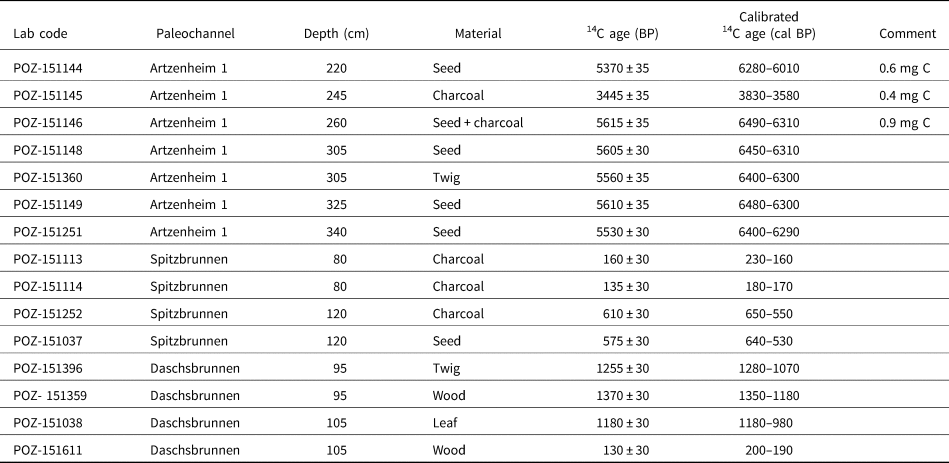
The chronological framework of the stratigraphic units and different paleochannels has been established by luminescence and radiocarbon dating. The ages of the sediments, which range from 22.0 ± 2.9 ka to 0.6 ± 0.1 ka, are presented within the context of the cores. Fifteen radiocarbon ages from peat and organic-rich sediments are listed in Table 1. With two exceptions, replicate radiocarbon measurements overlap within uncertainties, implying confidence in the dating results. However, some discrepancies in comparison to IRSL dating will be discussed later. For sample POZ-151145 (Artzenheim 1, depth 245 cm), one single age out of seven ages for the same peat horizon is outside the uncertainty range of the other samples. For this sample, the laboratory reported a very low carbon content (0.4 mg C), which may explain the outlier. For the other outlier (POZ-151611, Daschsbrunnen, depth 105 cm) no such explanation is available.
Accelerator mass spectrometry (AMS) radiocarbon (with 2σ uncertainties) data for the samples from Artzenheim 1, Daschsbrunnen, and Spitzbrunnen paleochannels.
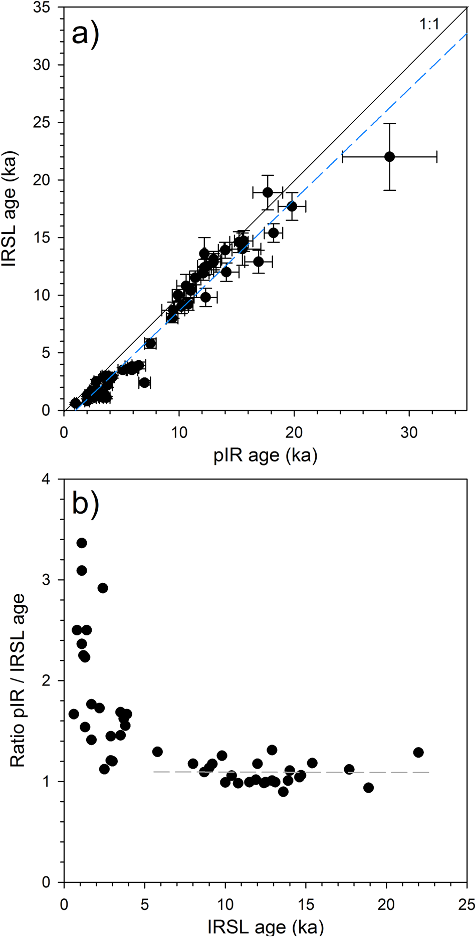
For luminescence dating, the fading-corrected IRSL and pIR ages are presented in Figure 5. In particular, the plot of pIR/IRSL age ratio versus IRSL age (Fig. 5b) reveals that there is only a slight offset in age for samples >5 ka (average ratio = 1.09 ± 0.12), but that the offset varies greatly and is very large for some samples <5 ka. We interpret this observation to reflect the larger effect of incomplete resetting of the pIR signal in young samples, where a small residual dose will have a large effect on the calculated age. This comparison also implies that the applied fading correction of the IRSL signal does sufficiently account for signal loss due to anomalous fading, giving confidence in the IRSL age estimates and leading to the preferential use of these over the pIR ages in the discussion of the chronological framework.
Comparison of fading-corrected infrared stimulated luminescence (IRSL) and post-IR (pIR) ages. (a) Direct plot of IRSL versus pIR and (b) plot of IRSL age versus the ratio pIR/IRSL age.
Descriptions of sediment cores
The stratigraphic logs of the investigated paleochannels and the natural levee of the Ill River are described in detail (see Supplementary Table S7 for geographic coordinates of the sediment cores). Descriptions are limited to the infill sediments, because the Pleistocene gravel (SU 1) ubiquitously forms the base of the cores (Figs. 6–9).
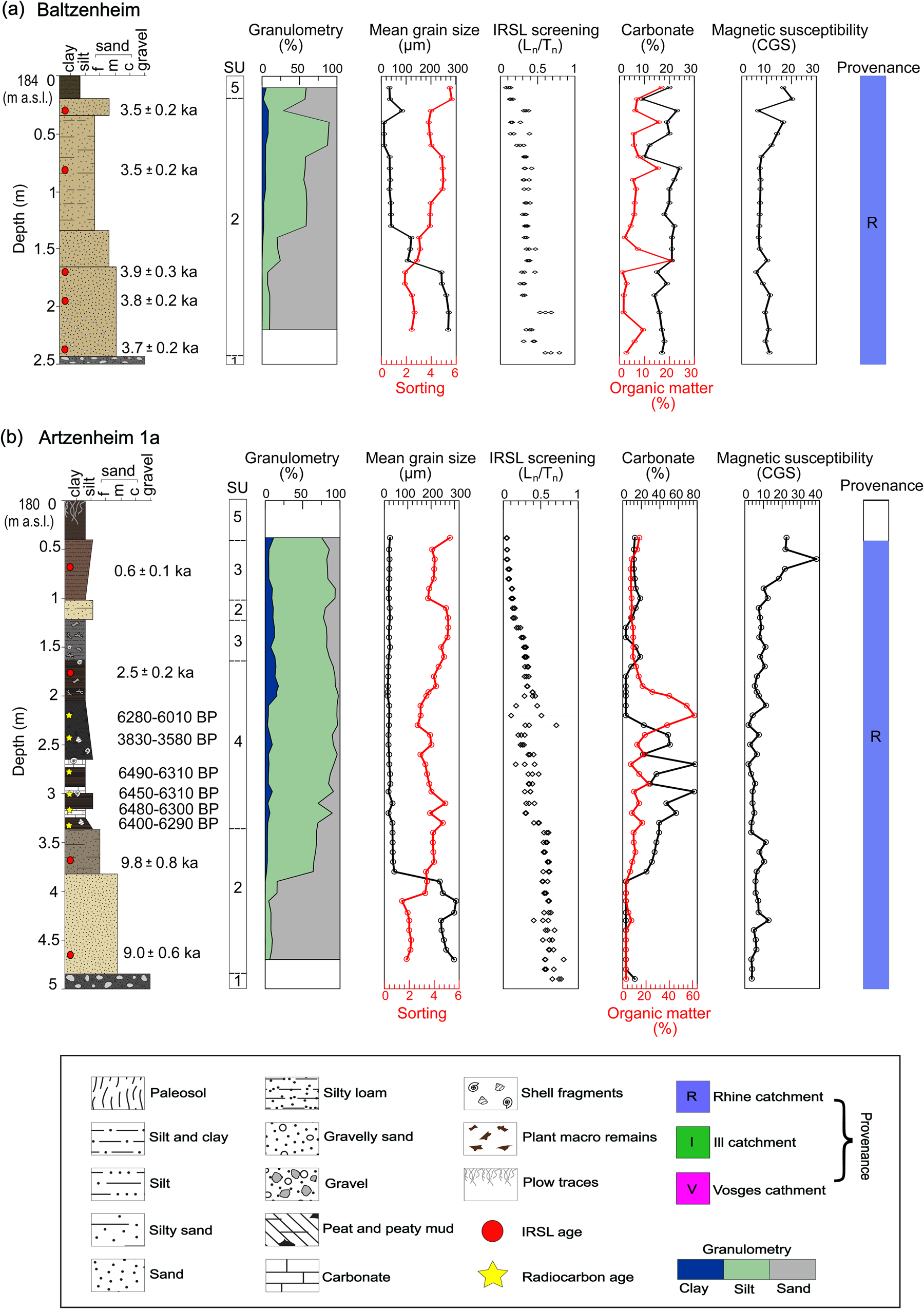
Stratigraphic logs of the (a) Baltzenheim and (b) Artzenheim 1a paleochannels (see Fig. 1c for paleochannel locations), illustrating facies association, chronological information, granulometry, sedimentological and geochemical data, and provenance of various sediment units.
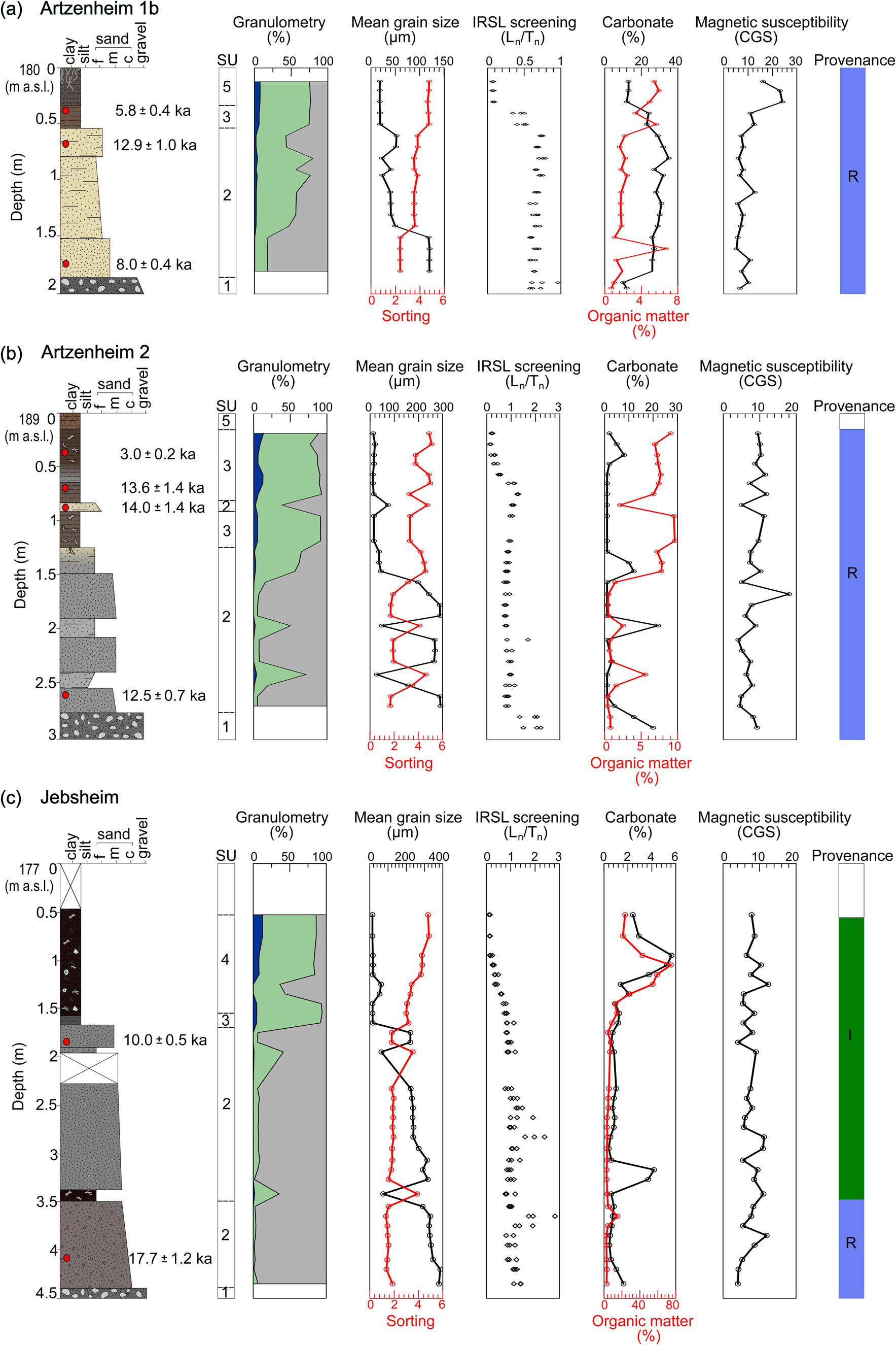
Stratigraphic logs of the (a) Artzenheim 1b, (b) Artzenheim 2, and (c) Jebsheim paleochannels (see Fig. 1c for paleochannel locations), illustrating facies association, chronological information, granulometry, sedimentological and geochemical data, and provenance of various sediment units. See Fig. 6 for the legend.
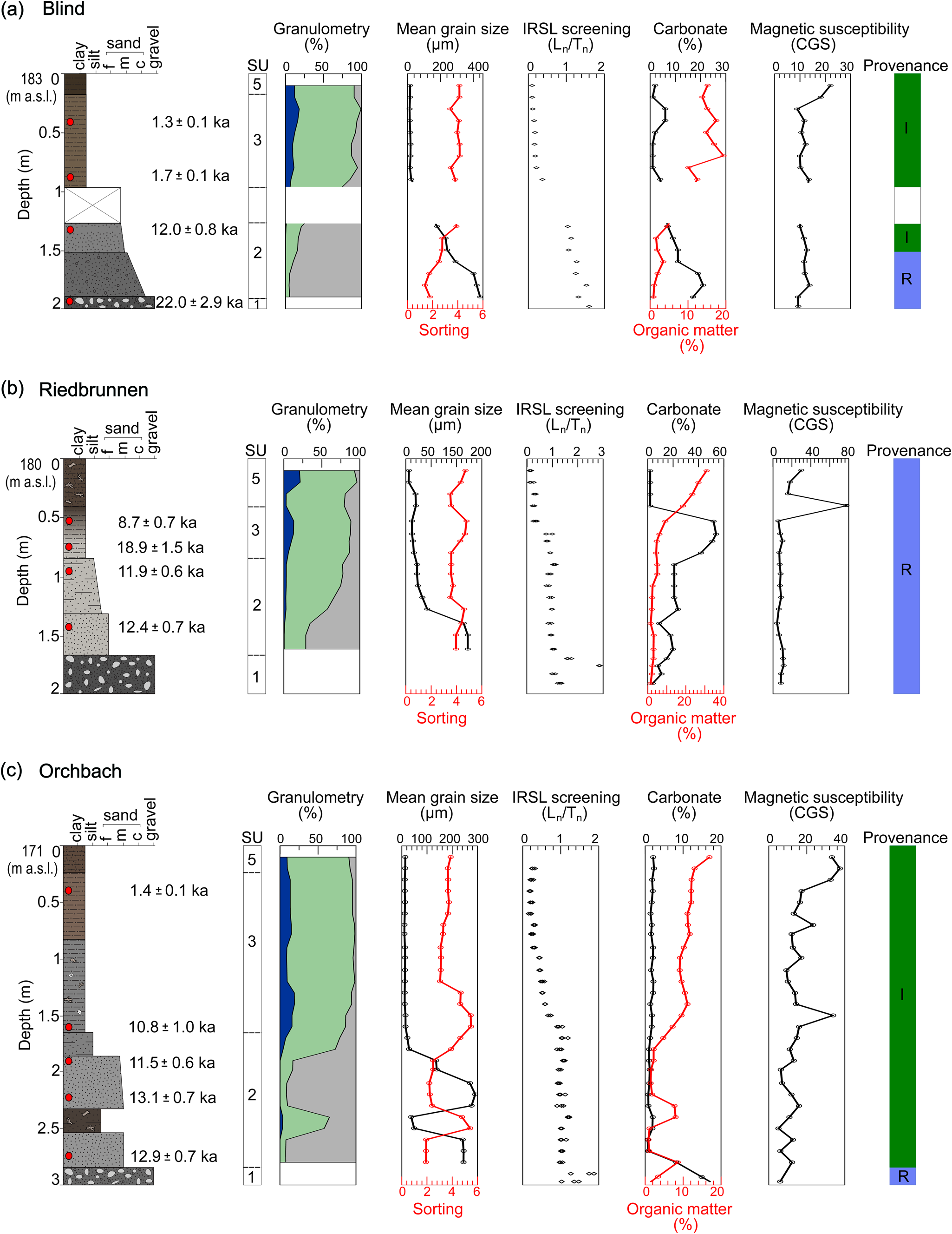
Stratigraphic logs of the (a) Blind, (b) Riedbrunnen, and (c) Orchbach paleochannels (see Fig. 1c for paleochannel locations), illustrating facies association, chronological information, granulometry, sedimentological and geochemical data, and provenance of various sediment units. See Fig. 6 for the legend.
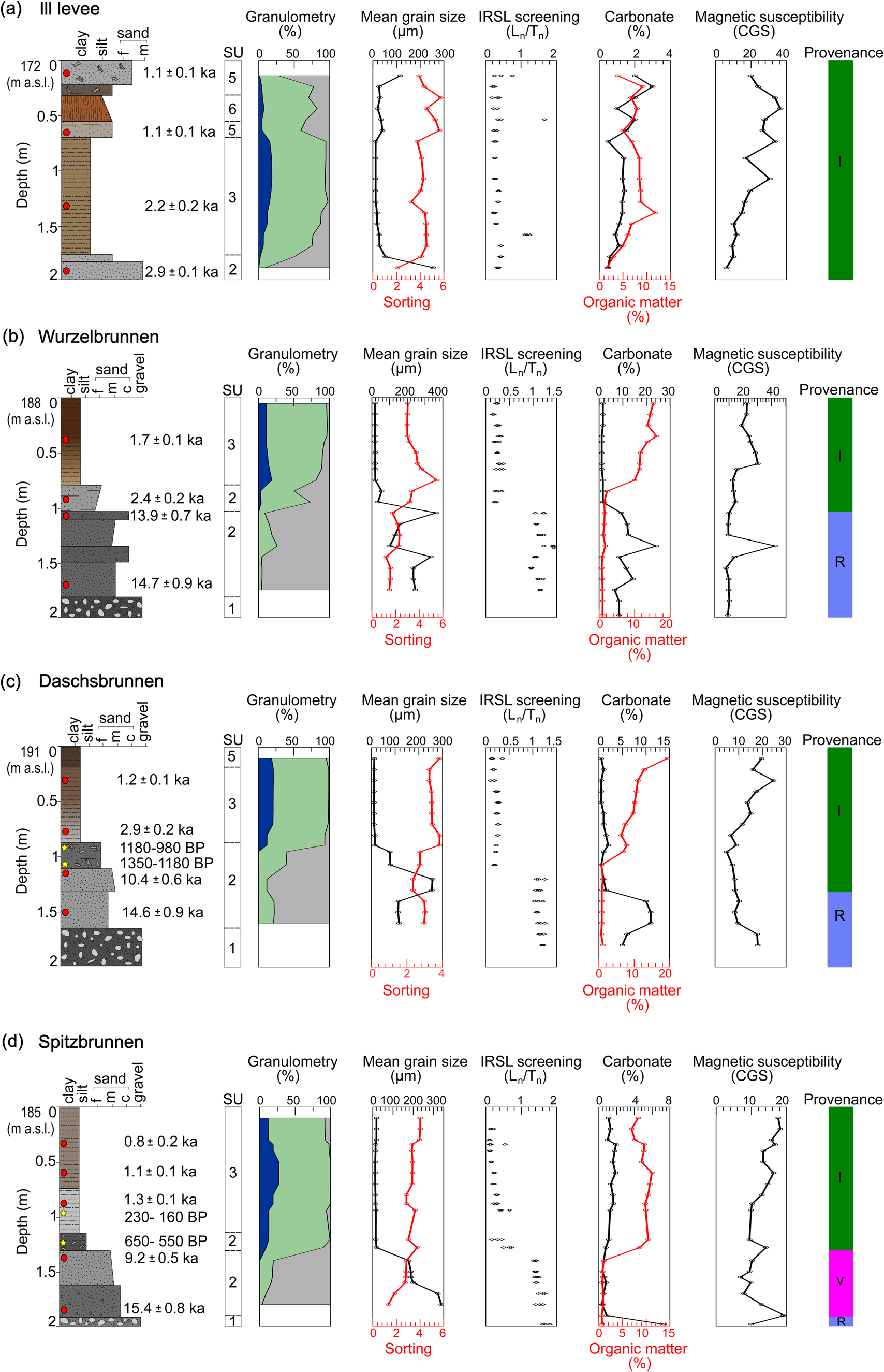
Stratigraphic logs of (a) the Ill levee and (b) Wurzelbrunnen, (c) Daschsbrunnen, and (d) Spitzbrunnen paleochannels (see Fig. 1c for levee and paleochannel locations), illustrating facies association, chronological information, granulometry, sedimentological and geochemical data, and provenance of various sediment units. See Fig. 6 for the legend.
Baltzenheim
This sediment core was obtained from the Baltzenheim paleochannel, which is about 2 km west of the present-day Rhine (Fig. 1c). The infill sequence begins at 2.4 m below surface (bs) with beige medium sand with occasional pebbles, which progressively grades to silty fine sand up to 0.35 m bs (Fig. 6a). From 0.35 to 0.20 m bs, another unit of medium sand interrupts the fining upward sequence, which is subsequently overlaid by a layer of dark-brown silty loam. Except for a few peaks, all the sediment units show low OM values but relatively high carbonate content (ca. 20%). IRSL screening reveals a single accumulation phase for the channel fills, with Ln/Tn values ranging from 0.1 to 0.4, but with outliers at 2.4 and 2.1 m bs, IRSL dating places the accumulation phase of the sandy units between 3.7 ± 0.2 and 3.5 ± 0.2 ka. According to the MIRS provenance data, this paleochannel's infills are totally attributable to the Rhine River catchment.
Artzenheim 1a
This core is the first of two sediment cores taken from the Artzenheim 1 paleochannel, located around 2.5 km west of the current Rhine (Fig. 1c). The lowermost part of the core, between 4.8 and 3.8 m bs, consists of beige medium sand with very low OM and carbonate content (Fig. 6b). This unit is overlain by brownish-gray silty fine sand (3.8–3.4 m bs) with higher OM content (ca. 10%) and a sharp increase in carbonate content (>30%). Clastic sediment deposition ceases at 3.4 m bs, with the accumulation of a 1.7-m-thick sequence of peat and peaty mud containing abundant plant macro-remains. This peat sequence is interbedded with thin carbonate layers (carbonate concretions and shell fragments) with very high carbonate concentrations (up to 70%). The basal sandy deposits are IRSL dated to 9.0 ± 0.6 and 9.8 ± 0.8 ka, respectively, while AMS radiocarbon dates for the overlying organic sediments (peat and gyttja) range from 6490 to 6010 cal BP (Fig. 6b, Table 1).
From 1.65 m bs, clastic fluvial deposition continues, first with gray clayey silt and then with beige silty sand (1.22–1.02 m bs). This is followed by brown clayey silt, which is topped by dark-brown silty loam. Overall, the Ln/Tn values of the channel fills decrease toward the top, ranging from 0.8 to 0.05, with some dispersion between 2.3 and 2.31 m bs. IRSL dating yielded an age of 2.5 ± 0.2 ka for the gray clayey silt and 0.6 ± 0.1 ka for the brown clayey silt. This paleochannel's sedimentary units all have a distinct Rhine provenance semblance.
Artzenheim 1b
This is the second sediment core from the Artzenheim 1 paleochannel. The 2-m-long core is mainly made up of beige fine to medium sand that grades into silty fine sand (Fig. 7a). These sandy channel fills have a relatively high carbonate content (>25%), whereas OM values are generally very low (<3%). The basal part of the sand units is dated to 8.0 ± 0.4 ka, while the upper silty sand layer yielded an IRSL age of 12.9 ± 1.0 ka. From 0.55 to 0.35 m bs, the sediments change to a thin clayey silt unit of comparable geochemical composition. The depositional age of this unit is 5.8 ± 0.4 ka. Brown silty loam makes up the uppermost 0.35 m of the core. OM levels are considerably higher than in the clayey silt, but the carbonate content is reduced to <15%. The Ln/Tn values of the channel fills average 0.7 between 1.8 and 0.6 m bs, with two values at 0.4 and 0.5 m bs recording an average of 0.5. Above 0.4 m bs, the Ln/Tn reveals very low values of around 0.07. All the sedimentary units here, like those in the Baltzenheim and Artzenheim 1a, are from the Rhine catchment.
Artzenheim 2
This 3-m-long sediment core was obtained from the Artzenheim 2 paleochannel, about 5 km west of the current Rhine (Fig. 1c). The lower part of the core, from 2.7 to 1.5 m bs, is composed of gray medium sand with some pebbles interspersed with two silty sand intervals. Except for a carbonate peak at 1.9 m bs, these sandy channel deposits have very low carbonate (ca. 2%) and OM content (1%). From 2.7 to 0.7 m bs, the channel fills have an average Ln/Tn value of around 1, but values above 0.7 m bs decrease steadily from 0.5 to 0.1. IRSL dating returned an age of 12.5 ± 0.7 for the lowermost part of the medium sand. From 1.5 to 1.3 m bs, there is a fining upward from medium sand to silty fine sand, with a corresponding increase in carbonate content (ca. 10%) and OM content (ca. 8%). The overlying sediment layer up to 0.7 m bs consists of dark-brown organic-rich clayey silt with a thin lens of silty fine sand (ca. 10 cm thick). This change in deposits is also accompanied by an increase in OM content while maintaining a very low carbonate content. The thin silty sand layer is dated to 14.0 ± 1.4 ka, whereas the overlying clayey silt shows an age of 13.6 ± 1.4 ka. A light-gray to brown clayey silt (0.5 m thick) with a depositional age of 3.0 ± 0.2 ka overlies the clayey silt, while the top 0.2 m of the core is composed of brown silty loam. All infill sediments of this paleochannel show a Rhine provenance.
Jebsheim
The sediment core from this paleochannel is 4.5 m long, with the lowermost part (4.4–3.5 m bs) composed of reddish-gray gravelly sand (Fig. 7c). Above this unit is a thin layer (~15 cm) of dark-brown, silty, fine sand containing partially disintegrated plant pieces. The next sediment layer up to 1.7 m bs consists of gray medium sand with an upper increase of fine sand. The sands are overlain by a thin layer of dark-gray clayey silt. Carbonate and OM content are very low for these units, except for the silty fine sand, which has rather relatively high OM values (ca. 15%). From the base of the channel to 1.7 m bs, the channel fills exhibit an average Ln/Tn value of 1.1, with considerably higher values recorded at 3.7 and 2.8 m bs. According to the IRSL age obtained at a depth of 4.1 m bs, the gravelly sand has a deposition age of 17.7 ± 1.2 ka. In contrast, the overlying medium sand unit is IRSL age dated to 10.0 ± 0.5 ka. A dark-brown peat layer interspersed with layers of peaty mud (between 1.6 and 0.5 m bs) overlies the sandy channel deposits. The peat has naturally high levels of OM (up to ~75%) and a relative increase in carbonate content in its upper part due mainly to shell fragments. Between 1.7 and 0.5 m bs, the peat layer shows Ln/Tn values that decline steadily from 0.7 to 0.05. Sediments from 0.5 m bs to the surface were not recovered due to sediment loss during coring. However, the cross-sectional profile of this paleochannel reveals that the peat layer extends to about 0.3 m depth and is followed by an organic-rich, dark-brown clayey silt (Supplementary Fig. S1). According to the MIRS data, the basal gravelly sand is Rhine sourced. The overlying units, silty sand, medium sand, clayey silt, and peat, on the other hand, are consistent with an Ill provenance source.
Blind
The basal part of the Blind sediment core (1.94–1.52 m bs) consists of gray gravelly sand with a depositional age of 22.0 ± 2.9 ka (Fig. 8a). This unit is topped by light-gray fine to medium sand between 1.52 and 1.28 m bs. From a depth of 1.28 to 0.97 m bs, sediment is missing in the core. However, the cross-sectional profile of the paleochannel reveals that the sand deposit extends to a depth of 0.97 m bs (Supplementary Fig. S1). IRSL dating reveals an age of 12.0 ± 0.8 ka (depth of 1.3 m) for the medium sand unit. Very low OM values but moderate carbonate content (up to 15%) characterizes these sandy deposits. The overlying strata comprises a brown clayey silt unit (ca. 1 m thick) that gradually transitions to an organic-rich clayey-silt unit that caps the sequence. These upper sediment units are distinguished by elevated values of OM but relatively low carbonate content. IRSL dating gives an age of 1.7 ± 0.1 ka for the lowermost part of the clayey silt and 1.3 ± 0.1 ka for its upper reaches. The Ln/Tn values in the lower half of the channel, from the base to 1.3 m bs, decrease steadily from 1.6 to 1, whereas values above 0.9 m bs are significantly lower, averaging 0.2. The basal gravelly sand unit has a Rhine origin, whereas the medium sand and clayey silt units are Ill derived.
Riedbrunnen
The basal part of this core (1.68–1.33 m bs) is made up of beige fine sand, which grades upward into silty sand between 1.33 and 0.85 m bs (Fig. 8b). OM values within these units are very low (<4%), whereas carbonate content averages around 15%. This unit is followed by a succession of light-gray clayey silt (0.85–0.42 m bs) with elevated carbonate content (>50%) but with low OM values. From the base of the fine sand unit to the middle of the clayey silt (1.68–0.7 m bs), the average Ln/Tn value of the channel fills is approximately 1. In contrast, values above 0.7 m bs are considerably lower and decrease steadily from 0.3 to 0.1. The IRSL dating shows an age of 12.4 ± 0.7 ka for the fine sand unit and 11.9 ± 0.6 ka at the top of the silty sand layer. The lower portion of the clayey silt (0.85–0.62 m bs) is dated to 18.9 ± 1.5 ka, while its upper part (0.62–0.42 m bs) has a depositional age of 8.7 ± 0.7 ka. The uppermost 0.4 m of the core consists of organic-rich silty loam with partially decayed plant macro-remains. This unit shows extremely low carbonate (ca. 1%) and high OM values (20–30%). Except for the uppermost unit (silty loam), all sedimentary units in the Riedbrunnen paleochannel have a Rhine provenance (Fig. 8b).
Orchbach
The Orchbach paleochannel is approximately 350 m east of the Ill River, sometimes closer (Fig. 1c). The 3-m-long sediment core recovered from this paleochannel comprises gray medium sand in its lowest section (2.85–2.55 m bs; Fig. 8c). A dark-brown organic-rich sandy silt (0.2 m thick) separates this basal sand from another gray medium sand from 2.34 to 1.87 m bs. Between 1.87 and 1.65 m bs, another layer of silty sand overlies this unit. Except for the organic-rich sandy silt, which has a moderate OM content (ca. 10%), all of these sandy channel fills have extremely low OM and carbonate concentrations. IRSL screening shows an average Ln/Tn value of 1.1 for these sandy units. The lower sand unit is dated to 12.9 ± 0.7 ka, while the upper sand unit has IRSL ages of 13.1 ± 0.7 ka at its base and 11.5 ± 0.6 ka at its top.
The sandy channel fills are overlain by a gray clayey silt unit (1.65–0.84 m bs) that progressively grades into brown clayey silt (0.84–0.25 m bs) containing a few shell fragments and plant macro-remains. Within these units, OM values are comparatively high (ca. 10–15%), although carbonate levels remain very low. The gray clayey silt unit shows decreasing-depth Ln/Tn values ranging from 0.3 to 0.9, whereas the brown clayey silt has more uniform values averaging 0.2. The IRSL dating yielded an age of 10.8 ± 1.0 ka for the lowest part of the gray clayey silt. In comparison, the upper portion of the brown clayey silt is dated to 1.4 ± 0.1 ka (Fig. 8c). The uppermost 0.25 m of the core is formed of dark-brown clayey silt with some sand. According to MIRS provenance data, all the sediment units of the Orchbach paleochannel are primarily attributed to the Ill catchment.
Levee
This sediment core was collected on the Ill River's natural levee (Fig. 1c). The sedimentary sequence begins with a gray medium sand grading to silty fine sand from 2.0 to 1.76 m bs (Fig. 9a). This is followed by a beige-to-brown clayey silt layer between 2.0 and 1.76 m bs and a silty sand layer between 0.71 and 0.57 m bs. The OM values for these units gradually increase (2–8%), but carbonate concentrations have low values. The medium sand and clayey silt units are IRSL dated to 2.9 ± 0.1 ka and 2.2 ± 0.2 ka, respectively, while the silty sand has a depositional age of 1.1 ± 0.1 ka. From 0.57 to 0.32 m bs, a break in sedimentation reveals the development of a reddish-brown paleosol. The paleosol horizon is characterized by a crumbly structure with granular peds and clay illuviation. From 0.32 m bs to the surface, sedimentation proceeds with the deposition of a silty sand unit that grades to fine sand containing abundant plant macro-remains. This unit is IRSL dated to 1.1 ± 0.1 ka. IRSL screening indicates low Ln/Tn values ranging from 0.1 to 0.4 for the levee's sedimentary sequence, with outliers at 2.10 and 2.40 m bs. All sediment units in this core show an Ill provenance.
Wurzelbrunnen
This Wurzelbrunnen paleochannel is located around 450 m to the west of the Ill River (Fig. 1c). The infill sequence of this 2-m-long sediment core begins with a gray medium to coarse sand unit between 1.81 and 1.50 m bs. This basal sand is separated from a gray medium sand unit between 1.36 and 1.11 m bs by a 0.14-m-thick layer of gravelly sand. Between 1.11 and 1.03 m bs, another layer of gravelly sand lies above this unit. The gravelly sand is covered by a layer of fine, light-gray silty sand (1.03–0.80 m bs). Except for the fine silty sand, which is carbonate-free, all sandy channel fills have significant carbonate concentrations (15–20%) but extremely low OM content (ca. 1–2%). IRSL screening reveals two distinct depositional periods for this paleochannel. A first phase between 1.81 and 1.03 m bs with average Ln/Tn values of 1.2 and a few outliers, followed by a second phase between 1.03 and 0 m bs with average values of 0.25. The lower coarse sand unit is IRSL dated to 14.7 ± 0.9 ka, while the upper gravelly sand unit has a depositional age of 13.9 ± 0.7 ka. In comparison, the silty sand is dated to 1.7 ± 0.1 ka (Fig. 9b). A brown–dark brown clayey silt unit that extends from 0.80 m bs to the surface overlies the sandy channel fills. Within this unit, OM values are relatively high (around 10–15%), while carbonate levels remain very low (ca. 1%). IRSL dates this unit to 2.4 ± 0.2 ka. MIRS analysis indicates that the coarse and gravelly sand units are formed of Rhine-derived sediments. The silty sand and clayey silt units, in contrast, are primarily associated with the Ill River.
Daschsbrunnen
The Daschsbrunnen paleochannel is also situated west of the Ill River, about 1 km from the present Ill River channel (Fig. 1c). This paleochannel's sediment core is 2 m long, with the lowermost part (1.65–1.33 m bs) composed of gray fine sand with scattered pebbles, grading to medium sand between 1.33 and 1.12 m bs (Fig. 9c). Following this is a 0.2-m-thick layer of gray silty sand with plant macro-remains. These units have very low OM and carbonate concentrations, except for the basal fine sand unit, which has a moderate carbonate content (ca. 10%). IRSL screening indicates two depositional phases for this paleochannel, similar to the Wurzelbrunnen paleochannel. An initial phase with average Ln/Tn values of 1.2 between 1.65 and 1.12 m bs, and a second phase with average values of 0.2 between 1.12 and 0.2 m bs. The fine sand has a depositional age of 14.6 ± 0.9 ka, according to IRSL data, while the overlying medium sand unit has an IRSL age of 10.4 ± 0.6 ka. Radiocarbon ages for the lower and upper parts of the silty sand date the unit to 1350 to 980 cal BP (Fig. 9c, Table 1). The overlying sediment unit is grayish-brown clayey silt from 0.89 to 0.20 m bs, while the uppermost part of the core, between 0.2 m bs and the surface, is dark-brown loamy silt. These units also have very low carbonate concentrations but relatively higher OM values. IRSL dating of the bottom and upper portions of the clayey silt places the age of the unit between 2.9 ± 0.2 ka and 1.2 ± 0.1 ka. The MIRS data show that the basal sandy channel infills have a Rhine origin, while the silty sand and clayey silt units show an Ill signature (Fig. 9c).
Spitzbrunnen
The Spitzbrunnen paleochannel is located around 2.2 km east of the Fecht River and 1.9 km west of the Ill River and is the most westerly of the investigated paleochannels (Fig. 1c). The sediment infill begins with dark-gray gravelly sand (1.92–1.64 m bs) that progresses to gray medium sand from 1.64 to 1.31 m bs (Fig. 9d). These units show very low OM values and are mainly carbonate-free, while the average Ln/Tn value is 1.5. IRSL dates the gravelly sand to 15.4 ± 0.8 ka, whereas the medium sand dates to 9.2 ± 0.5 ka. The next sediment layer up to 1.15 m bs comprises dark-gray silt with abundant plant macro-remains. According to two radiocarbon ages obtained at 1.2 m bs, the deposition of this unit was between 530 and 650 cal BP (Fig. 9d, Table 1). The next layer is a light-gray clayey silt between 1.15 and 0.75 m bs, which changes to brownish-gray clayey silt at 0.75 m and continues to the surface. Very low carbonate levels characterize these silty units but comparatively higher OM values (ca. 10%). From the base of the dark-gray silt to the top of the brownish-gray clayey silt, the Ln/Tn values decrease progressively from 0.7 to 0.1, with a few scatters recorded at 1.21 and 0.34 m bs. Two radiocarbon ages obtained at 0.90 m bs date the light-gray clayey silt unit between 160 to 230 cal BP (Fig. 9d, Table 1), whereas IRSL dating at 0.85 m bs yielded an age of 1.3 ± 0.1 ka for this unit (Fig. 9d, Supplementary Table S6).
A comparable depositional age of 1.1 ± 0.1 ka is recorded for the overlying grayish-brown clayey silt. According to the MIRS data, the basal gravel unit has a Rhine origin; the sand units are predominantly from the Vosges source area, whereas the overlying silty units originate from the Ill catchment (Fig. 9d).
Discussion
Dating inconsistencies
The radiocarbon ages from the Daschsbrunnen and Spitzbrunnen paleochannels of 1350 to 160 cal BP (Fig. 9c and d, Table 1) are not in stratigraphic order and younger than the IRSL-dated stratigraphic units above them (Fig. 9c and d). These discrepancies suggest that either the radiocarbon ages are underestimating or the IRSL ages are overestimating. However, radiocarbon ages reported for comparable stratigraphic units from neighboring paleochannels (Al Siddik, Reference Al Siddik1986; Al Siddik et al., Reference Al Siddik, Party, Mettauer, Schenck and Guillet1989) are consistent with our IRSL ages and fall within the same age interval. Hence, we consider the radiocarbon ages obtained from the Daschsbrunnen and Spitzbrunnen paleochannels too young (underestimated). These anomalously young radiocarbon ages are most likely due to contamination with younger carbon during the sampling or preparation process. Therefore, the radiocarbon ages obtained from the Daschsbrunnen and Spitzbrunnen paleochannels are disregarded for subsequent interpretations.
The reported IRSL ages are generally consistent and in stratigraphic order, except for two samples: Az1b-70 cm (Artzenheim 1b, depth 70 cm) and Ried 70 cm (Riedbrunnen, depth 70 cm). These ages are much older than those of the stratigraphic units below them (Figs. 7a and 8b, Supplementary Table S6). Considering their stratigraphic placement, the ages of samples Az1b-70 cm (12.9 ± 1.0 ka) and Ried-70 cm (11.9 ± 0.6 ka) seem largely overestimated. This is likely due to older sediments being reworked and redeposited in the paleochannels. During high flood events, sediments from proximal Hardt Grise areas (reworked Pleistocene terrace of the Rhine; Fig. 3) could have been eroded and redeposited in paleochannels. The sediments would only have been transported over a short distance and therefore would likely have been only very briefly exposed to daylight, resulting in higher age estimates than expected. Calcareous sediments from the Hardt Grise have also been documented in some Holocene paleochannels south of Illhaeusern (Al Siddik, Reference Al Siddik1986; Al Siddik et al., Reference Al Siddik, Party, Mettauer, Schenck and Guillet1989). This is consistent with the occurrence of older Hardt Grise sediments in Artzenheim 1b, which is located very close to a Hardt Grise area. Similar sediments are also found in the Riedbrunnen paleochannel, located downstream of the Hardt Grise area, southwest of Bischwihr (Figs. 3 and 4; Hirth, Reference Hirth1971). Moreover, sediment input from the Hardt Grise explains the high carbonate content and unexpected Rhine provenance of the upper sediment successions of the Riedbrunnen paleochannel (Fig. 8b) despite its remoteness from the Rhine (Fig. 4).
Facies assignment
The sedimentary deposits in the investigated paleochannels and levee are classified into six lithogenetic units (SU 1 to SU 6). Except for the paleosol (SU 6), these units have been previously described by Abdulkarim et al. (Reference Abdulkarim, Chapkanski, Ertlen, Mahmood, Obioha, Preusser, Rambeau, Salomon, Schiemann and Schmitt2022) based mainly on hand-augured core data. However, the present study additionally integrates sedimentological, geochemical, and geochronological data to highlight unit characteristics further and validate the groupings. The lithogenetic units represent distinct energy conditions, sediment transport and deposition processes, and different phases of channel activity. Thus, identifying these units and establishing their provenance and ages enables reconstruction of past fluvial activity in the area.
SU 1 consists of cobble-rich gravelly sediments found at the base of the paleochannels. It differs from units above due to larger particle sizes, gravel predominance, and poorly sorted sediments (Figs. 6–9), suggesting formation through nonselective bedload transport under high-energy depositional conditions (e.g., Chardon et al., Reference Chardon, Schmitt, Arnaud, Piégay and Clutier2021). These gravel deposits show an unambiguous Rhine origin (from MIRS analysis), often with high carbonate content and minimal OM. Interpreted as Pleistocene Rhine gravel, SU 1, while not constituting the direct infill of the paleochannels, may be geomorphologically reworked and deposited within them, providing crucial insights into channel dynamics.
SU 2 is composed of sands, gravelly sands, and silty sands in a fining upward sequence with moderate to poor sorting (Figs. 6–9). These sandy successions, featuring gravelly channel lags and sandy channel infills, indicate deposition at the onset of infill during moderate- to high-energy flow episodes (e.g., Plotzki et al., Reference Plotzki, May, Preusser, Roesti, Denier, Lombardo and Veit2015; Delile et al., Reference Delile, Schmitt, Jacob-Rousseau, Grosprêtre, Privolt and Preusser2016). The SU 2 deposits are found at varied depths and range in age from the late glacial to the Late Holocene. Furthermore, they bear Rhine, Ill, and Vosges provenance signatures. Thus, SU 2 units give evidence of channel activity and deposition during a permanent or irregular connection to the different river systems in the region.
SU 3 generally consists of fine-grained silty and clayey sediments, occasionally with thin layers of very fine sand. These well-sorted sediments have higher OM content than SU 2 and contain shell fragments and plant macro-remains (Figs. 6–9). The sedimentary characteristics and stratigraphic position of these deposits imply deposition in low- to very low energy depositional environments. Furthermore, their transport and deposition underline mostly homogenous suspension (e.g., Delile et al., Reference Delile, Schmitt, Jacob-Rousseau, Grosprêtre, Privolt and Preusser2016), which could indicate channels with no (or only a limited) upstream hydrological link to a basin-fed river. The SU 3 deposits are mainly found directly above SU 2 deposits and span in age from the late glacial to the Late Holocene, also with different provenance sources. Thus, SU 3 sediments serve as key stratigraphic indicators for identifying phases of decreased fluvial activity and partial disconnection from feeding rivers (upstream).
Lithogenetic unit SU 4, found exclusively in the Artzenheim 1 and Jebsheim paleochannels (Fig. 6b and 7c), consists of dark-brown to black peat and peaty mud rich in OM, with abundant plant macro-remains. Some sections contain shell fragments and very thin, intermittent clastics (coarse sand and pebbles). In the Artzenheim 1 paleochannel, thin carbonate layers interlace with peaty mud, distinguished by extremely high carbonate concentration, low OM content, and the absence of plant macro-remains (Fig. 6b). The unit's sedimentary characteristics indicate autochthonous sedimentation with limited clastic deposition in settings of very low flow energy or stagnant water. Thus, the SU 4 lithogenetic unit marks a period of slowed or ceased fluvial activity in the Mid Holocene.
SU 5 comprises young surficial deposits (Subatlantic to Recent) that typically cap older units. These sediments, composed of clayey silt to silty loam with reworked sands, share similarities with SU 3 but differ in stratigraphy and genesis. SU 5 is formed through overbank deposition and is characterized by its darker colors, higher OM content, and fragmented plant macro-remains (Figs. 6–9). In addition, plowing traces and pedogenetic processes are frequently observed in the upper sections. The SU 5 lithogenetic unit indicates near-total channel abandonment, very low sedimentation rates, and nearly stable surface conditions.
SU 6 is limited to the natural levee of the Ill River, where it reaches a thickness of 25 cm (Fig. 8a). This unit, which represents a paleosol horizon, is distinguished by its distinctive rusty-brown color, lack of apparent laminations, and crumbly structure with granular peds and clay illuviation. This horizon lies between SU 5 units dated to the Late Holocene (1.1 ± 0.1 ka), indicating a short period of geomorphic stability and soil formation near the current Ill River channel during the Late Holocene.
Temporal trajectory of the fluvial hydrosystems
The data from this study and additional data from earlier studies (Hirth, Reference Hirth1971; Al Siddik, Reference Al Siddik1986; Boës et al., Reference Boës, Schmitt, Schwartz, Gebhardt, Goepp, Lasserre, Barral, Daubigney, Dunning, Kaenel and Roulière-Lambert2007; Schmitt et al., Reference Schmitt, Houssier, Martin, Beiner, Skupinski, Boës and Schwartz2016; Chapkanski et al., Reference Chapkanski, Ertlen, Rambeau and Schmitt2020; Abdulkarim et al., Reference Abdulkarim, Chapkanski, Ertlen, Mahmood, Obioha, Preusser, Rambeau, Salomon, Schiemann and Schmitt2022) were combined to reconstruct the late glacial and Holocene temporal trajectories of the fluvial hydrosystems in this section of the Upper Rhine alluvial plain, in response to different potential driving factors.
Late glacial (Oldest Dryas, Bølling-Allerød, Younger Dryas)
Channel activity during the Oldest Dryas stade is indicated by the coarse-grained channel fills of the Artzenheim 2 (PG 1), Jebsheim (PG 2), Blind (PG 3), Riedbrunnen (PG 3), Wurzelbrunnen (PG 3), Daschsbrunnen (PG 3), and Spitzbrunnen (PG 5) paleochannels. These deposits reflect rapid sedimentation (based on IRSL screening and IRSL dating data; Figs. 6–9, Supplementary Table S6) in a high-energy flow and depositional environment exclusively reflecting Rhine provenance. Based on the character of these deposits and the spatial distribution of the paleochannels, a braided Rhine system occupied nearly the entire alluvial plain during the Oldest Dryas (Fig. 10). This period was generally cold and arid, with reduced vegetation cover, much greater flow during floods, and high bedload (Kolstrup, Reference Kolstrup1980; Vogt, Reference Vogt1992; Mol et al., Reference Mol, Vandenberghe and Kasse2000). Moreover, during this period, a braided pattern was characteristic for other parts of the Upper Rhine River (Lang et al., Reference Lang, Bork, Mäckel, Preston, Wunderlich and Dikau2003; Erkens et al., Reference Erkens, Dambeck, Volleberg, Bouman, Bos, Cohen, Wallinga and Hoek2009; Lämmermann-Barthel et al., Reference Lämmermann-Barthel, Neeb, Hinderer and Frechen2009) and was dominant in many other fluvial systems in northwestern and central Europe (Vandenberghe et al., Reference Vandenberghe, Kasse, Bohncke and Kozarski1994; Huisink Reference Huisink1997; Mol et al., Reference Mol, Vandenberghe and Kasse2000; Antoine et al., Reference Antoine, Munaut, Limondin-Lozouet, Ponel, Dupéron and Dupéron2003; Kasse et al., Reference Kasse, Hoek, Bohncke, Konert, Weijers, Cassee and Van Der Zee2005, Reference Kasse, Bohncke, Vandenberghe and Gábris2010; Gao et al., Reference Gao, Boreham, Preece, Gibbard and Briant2007).
(a) Schematic reconstruction of the late glacial and Holocene fluvial temporal trajectory of the Rhine, Ill, and Fecht River systems in the study area. (b) A synthesis of changes in fluvial channel pattern during the late glacial and Holocene. Subdivision of late glacial and Holocene climatic periods according to Ivy-Ochs et al. (Reference Ivy-Ochs, Schäfer, Kubik, Synal and Schlüchter2004), Schirmer et al. (Reference Schirmer, Bos, Dambeck, Hinderer, Preston, Schulte, Schwalb and Wessels2005), Bos et al. (Reference Bos, Dambeck, Kalis, Schweizer and Thiemeyer2008), and Kock et al. (Reference Kock, Huggenberger, Preusser, Rentzel and Wetzel2009). Abbreviations: OD, Older Dryas; B-A, Bølling-Allerød; YD, Younger Dryas; PB, Preboreal; BO, Boreal; AT, Atlantic; SB, Subboreal; SA, Subatlantic.

However, sediments in the Spitzbrunnen paleochannel (PG 5) dating to the Oldest Dryas show a strong Vosges catchment provenance (Fig. 9d), indicating that the Fecht River, or a precursor Fecht system, evolved independent dynamics during this period. In addition, Hirth (Reference Hirth1971) and Abdulkarim et al. (Reference Abdulkarim, Chapkanski, Ertlen, Mahmood, Obioha, Preusser, Rambeau, Salomon, Schiemann and Schmitt2022) identified parallels in the morphologic characters of the Spitzbrunnen paleochannel and the contemporary Fecht channel. The channel pattern of the Fecht during this period is undetermined. However, based on the coarse-grained nature of the Spitzbrunnen sediments, the prevailing climatic and environmental conditions, and the potential high bedload supply by the Fecht basin during this period, we assume a braided system, albeit a smaller one compared with the Rhine.
The transition from the Oldest Dryas to the Bølling-Allerød interstade is marked by the abandonment of braided Rhine channels, particularly in the western part of the plain (e.g., Daschsbrunnen and Wurzelbrunnen; PG 3), linked to the narrowing and eastward migration of the Rhine's active belt (Fig. 10). According to Dambeck and Thiemeyer (Reference Dambeck and Thiemeyer2002), the northern Upper Rhine River evolved a meandering pattern during the Allerød, while Mäckel (Reference Mäckel, Mäckel and Friedmann1998) suggests that the entire Upper Rhine River developed a meandering pattern at the onset of the late glacial. However, our findings indicate concurrent channel activity during the Bølling-Allerød, as evidenced by the Riedbrunnen (PG 3) and Artzenheim 2 (PG 1) paleochannels. Notably, the channel fills consist of finer-grained sands, indicating a relatively moderate-energy environment. Thus, we hypothesize that the Rhine was still a multichannel river in this section of the Upper Rhine plain during the Bølling-Allerød, but with a complex pattern combining braided close to the thalweg and anastomosing at the margin of the fluvial hydrosystem. Furthermore, anabranching channels (Nanson and Knighton, Reference Nanson and Knighton1996) were probably also present between these two pattern types (Schmitt et al., Reference Schmitt, Houssier, Martin, Beiner, Skupinski, Boës and Schwartz2016). Similar complex, multi-threaded fluvial patterns during the interstades have been documented for parts of the northern Upper Rhine (Erkens et al., Reference Erkens, Dambeck, Volleberg, Bouman, Bos, Cohen, Wallinga and Hoek2009), the Meuse River (Vandenberghe et al., Reference Vandenberghe, Kasse, Bohncke and Kozarski1994; Huisink Reference Huisink1997, Reference Huisink1999; Kasse et al., Reference Kasse, Hoek, Bohncke, Konert, Weijers, Cassee and Van Der Zee2005), the Niers-Rhine (Kasse et al., Reference Kasse, Hoek, Bohncke, Konert, Weijers, Cassee and Van Der Zee2005), and the Warta River (Vandenberghe, Reference Vandenberghe1995).
The narrowing of the Rhine braided belt and partial changes in channel planform is most likely related to the climatic warming of the Bølling-Allerød and the resulting increase in vegetation cover (Schneider, Reference Schneider2000; Kasse et al., Reference Kasse, Bohncke, Vandenberghe and Gábris2010 and references therein; Hoek et al., Reference Hoek, Lammertsma, Bohncke, Bos, Bunnik, Kasse, Schokker and Westerhoff2017), lower discharge, and decreased sediment supply by the basin (Kasse et al., Reference Kasse, Bohncke, Vandenberghe and Gábris2010 and references therein). Alpine glacier retreats during the Oldest Dryas and the subsequent formation of numerous Alpine lakes (Hinderer, Reference Hinderer2001; Ivy-Ochs et al., Reference Ivy-Ochs, Schäfer, Kubik, Synal and Schlüchter2004) have also strongly influenced these fluvial dynamics, as these lakes functions as natural sediment traps (Wessels, Reference Wessels1998; Hinderer, Reference Hinderer2001).
The transition to the Bølling-Allerød interstade with the Rhine narrowing and migrating eastward also explains the emergence of an individualized Ill River system in the study area. This appears evident in the Orchbach paleochannel (PG 3), where sediments originating from the Ill catchment were deposited during the Bølling-Allerød interstade (Fig. 8c). Schmitt et al. (Reference Schmitt, Houssier, Martin, Beiner, Skupinski, Boës and Schwartz2016) considered that the Ill hydrosystem formed at the start of the Holocene, but our findings place this about 2000 years earlier. The diminution of Alpine glaciers together with the narrowing of the Rhine active band, which moved eastward, is believed to have prompted the individualization of the Ill River during the Bølling-Allerød. However, unlike the Rhine sediments, Ill sediments were only found in the Orchbach paleochannel (PG 3). Consequently, we deduce that the Ill River was probably mostly meandering-like during this time period, but the formation of an anastomosing pattern for the Ill River had probably already begun at this time, possibly due to the morphological inheritance of the former braided Rhine pattern.
In contrast to the Oldest Dryas stade and Bølling-Allerød interstade, the channel morphology and infill successions do not evidence significant changes in fluvial processes associated with the Younger Dryas stade in the Upper Rhine plain. The Rhine and Ill systems probably maintained their combined braided-anastomosing and meandering-like patterns, respectively. This trend toward channel pattern stability at the beginning of the Younger Dryas has been documented for the northern Upper Rhine (Dambeck and Thiemeyer, Reference Dambeck and Thiemeyer2002; Bos et al., Reference Bos, Dambeck, Kalis, Schweizer and Thiemeyer2008; Erkens et al., Reference Erkens, Dambeck, Volleberg, Bouman, Bos, Cohen, Wallinga and Hoek2009), as well as for other European rivers such as the Warta River (Vandenberghe et al., Reference Vandenberghe, Kasse, Bohncke and Kozarski1994; Vandenberghe, Reference Vandenberghe1995), Bergstrassen-Neckar (Dambeck and Thiemeyer, Reference Dambeck and Thiemeyer2002; Bos et al., Reference Bos, Dambeck, Kalis, Schweizer and Thiemeyer2008), middle Tisza (Kasse et al., Reference Kasse, Bohncke, Vandenberghe and Gábris2010), Niers-Rhine (Kasse et al., Reference Kasse, Hoek, Bohncke, Konert, Weijers, Cassee and Van Der Zee2005), and Lower Scheldt (Meylemans et al., Reference Meylemans, Bogemans, Storme, Perdaen, Verdurmen and Deforce2013). The lack of fluvial adjustments in response to the Younger Dryas climatic oscillation may be attributable to the buffering effect that the massive Rhine system had against climate change (Bos et al., Reference Bos, Dambeck, Kalis, Schweizer and Thiemeyer2008) and the preservation of forest cover during the Younger Dryas (Schneider, Reference Schneider2000; Bos et al., Reference Bos, Dambeck, Kalis, Schweizer and Thiemeyer2008). Furthermore, the inherent characteristics of the alluvial plain (e.g., its broad width of more than 15–20 km) may also explain, at least partly, the lack of major fluvial adjustment to climate change (Vayssière et al., Reference Vayssière, Rué, Recq, Gardère, Thamó-Bozsó, Castanet, Virmoux and Gautier2019 and references therein).
Early to Mid-Holocene (Preboreal, Boreal, and Atlantic)
According to our findings and previous studies (e.g., Boës et al., Reference Boës, Schmitt, Schwartz, Gebhardt, Goepp, Lasserre, Barral, Daubigney, Dunning, Kaenel and Roulière-Lambert2007; Schmitt et al., Reference Schmitt, Houssier, Martin, Beiner, Skupinski, Boës and Schwartz2016), the Rhine at the Early Holocene was restricted to the alluvial plain's central and eastern reaches (Fig. 10). The channel pattern combined a braided and anastomosing pattern (Schmitt et al., Reference Schmitt, Houssier, Martin, Beiner, Skupinski, Boës and Schwartz2016). This pattern contrasts with those of the northern Upper Rhine (Dambeck and Thiemeyer, Reference Dambeck and Thiemeyer2002; Bos et al., Reference Bos, Dambeck, Kalis, Schweizer and Thiemeyer2008; Erkens et al., Reference Erkens, Dambeck, Volleberg, Bouman, Bos, Cohen, Wallinga and Hoek2009) and other European rivers (Vandenberghe et al., Reference Vandenberghe, Kasse, Bohncke and Kozarski1994; Huisink, Reference Huisink1999), which are understood to have developed large-scale, single-thread meandering patterns in the Early Holocene. The development of a meandering pattern in these European rivers is attributed mainly to the renewed climatic warming of the Early Holocene and the associated lower discharges, decreased sediment supply, increased vegetation cover, relative bank stabilization, and low valley gradient. Thus, the evolution of an anastomosing channel pattern in the studied reach of the Upper Rhine was probably influenced by factors other than Early Holocene climate warming and environmental changes.
Possible controlling factors in the studied reach include the important width of the alluvial plain, a relatively low valley gradient (0.8–0.6%) compared with the upstream section of the alluvial plain, relative tectonic subsidence compared with the upstream and downstream areas (Vogt, Reference Vogt1992), and a propensity for sedimentation by fine sediments on the floodplain (Hirth, Reference Hirth1971; Ollive et al., Reference Ollive, Petit, Garcia and Reddé2006; Schmitt et al., Reference Schmitt, Houssier, Martin, Beiner, Skupinski, Boës and Schwartz2016). This Holocene aggradation was also caused by the upstream Holocene incision of the Rhine River (Lämmermann-Barthel et al., Reference Lämmermann-Barthel, Neeb, Hinderer and Frechen2009; Schmitt et al., Reference Schmitt, Houssier, Martin, Beiner, Skupinski, Boës and Schwartz2016). In addition to these factors, Rhine side channels probably reoccupied numerous relict channels of the late glacial braided system (as well as younger braided Rhine channels when the Rhine moved eastward), which may have favored the anastomosing channel pattern. Thus, it appears that the late glacial braided Rhine system gradually metamorphosed into a moderate-energy braided-anastomosing system in the Early Holocene through a complex interplay of both climatic and non-climatic mechanisms.
The transition to the Holocene was also accompanied by significant changes to the Ill fluvial hydrosystem. Our data show that the Ill channel at Orchbach was abandoned around the beginning of the Holocene. At the same time, Ill-derived channel fills were deposited in the Blind (PG 3) and Jebsheim (PG 2) paleochannels between 12.0 ± 0.8 and 10.0 ± 0.5 ka (Figs. 7c and 8a, Supplementary Table S6). These changes in dynamics point to an active channel (or some significant side channels of the Ill River) in the central part of the plain from the start of the Holocene. Moreover, previous studies (e.g., Boës et al., Reference Boës, Schmitt, Schwartz, Gebhardt, Goepp, Lasserre, Barral, Daubigney, Dunning, Kaenel and Roulière-Lambert2007; Schmitt et al., Reference Schmitt, Houssier, Martin, Beiner, Skupinski, Boës and Schwartz2016; Chapkanski et al., Reference Chapkanski, Ertlen, Rambeau and Schmitt2020) have also documented Ill-derived channel fills dating to the Preboreal in some paleochannels in the central part of the alluvial plain. Accordingly, we contend that during the Early Holocene, as the active channel belt of the Rhine narrowed and shifted eastward, a Holocene Ill system evolved in the central part of the plain, reoccupying some abandoned Rhine channels. The newly formed Ill River showed concurrent activity in multiple channels, indicating that it was probably larger than its predecessor. It also adapted its morphology from a meandering-like pattern to a well-defined, multi-threaded anastomosing system, influenced by alluvial plain–scale controlling factors comparable to those influencing the Rhine (Schmitt et al., Reference Schmitt, Houssier, Martin, Beiner, Skupinski, Boës and Schwartz2016).
The Rhine and Ill Rivers maintained their patterns throughout the Preboreal, Boreal, and early Atlantic. In addition, the Rhine probably gradually moved eastward during this phase, while the Ill River moved westward (Hirth, Reference Hirth1971; Schmitt et al., Reference Schmitt, Houssier, Martin, Beiner, Skupinski, Boës and Schwartz2016). In contrast, the second half of the Atlantic is characterized by a slowdown of fluvial dynamics, with very low lateral channel dynamics. This phase was most likely fostered by the period's climatic evolution (warming), which resulted in a densely forested alluvial plain (Dambeck and Thiemeyer, Reference Dambeck and Thiemeyer2002; Lang et al., Reference Lang, Bork, Mäckel, Preston, Wunderlich and Dikau2003; Bos et al., Reference Bos, Dambeck, Kalis, Schweizer and Thiemeyer2008). Thus, the late Atlantic is characterized by a general decline in clastic channel fills in most of the investigated paleochannels and contemporaneous deposition of peat and organic sediments in some Early Holocene paleochannels, for example, Artzenheim 1 (PG 1) and Jebsheim (PG 2) (Figs. 6b and 7c).
Peat accumulation in the Artzenheim 1 paleochannel (PG 1) dates to the late Atlantic (Fig. 6b, Table 1). By considering peat dating from several paleochannels near Illhaeusern (Al Siddik et al., Reference Al Siddik, Party, Mettauer, Schenck and Guillet1989; Chapkanski et al., Reference Chapkanski, Ertlen, Rambeau and Schmitt2020), we bracket the interval of the major organic sedimentation (peat and peaty mud) between the early Subboreal and late Atlantic. This interval agrees well with the period of enhanced peat and organic sedimentation recorded in other areas of the Upper Rhine Valley (e.g., Schneider, Reference Schneider2000; Dambeck and Thiemeyer, Reference Dambeck and Thiemeyer2002; Bos et al., Reference Bos, Dambeck, Kalis, Schweizer and Thiemeyer2008; Erkens et al., Reference Erkens, Hoffmann, Gerlach and Klostermann2011). Although this phase was characterized by reduced fluvial dynamics, intermittent clastics (sand and some pebbles) within the peat indicate that there were episodic flooding events. Consequently, we propose the early Subboreal to late Atlantic was a period of generally low fluvial activity, punctuated by periodic flooding with increased energy in the channel.
In contrast to the Rhine and Ill Rivers, the Fecht River's post-Preboreal trajectory remains vague. Nonetheless, we assume that it moved westward after abandoning the Spitzbrunnen paleochannel during the Preboreal (Fig. 9d). The absence of Vosgian sediment infill to the east of the Spitzbrunnen paleochannel (PG 5) supports this presumption.
Mid- to Late Holocene (Subboreal and Subatlantic periods)
The onset of the Subboreal, marked by a generally colder climate and reduced vegetation cover (Schneider, Reference Schneider2000; Bos et al., Reference Bos, Dambeck, Kalis, Schweizer and Thiemeyer2008), is characterized by a consequent resumption of fluvial dynamics. This is evidenced by the deposition of clastic channel fills and the contemporaneous cessation of peat accumulation. During the Subboreal, the densely forested Upper Rhine plain transformed into a more open landscape, with a decrease in woodlands and an expansion of meadows as well as agricultural activities, the latter at scales of both the alluvial plain and the catchment (Schneider, Reference Schneider2000; Dambeck and Thiemeyer, Reference Dambeck and Thiemeyer2002; Lang et al., Reference Lang, Bork, Mäckel, Preston, Wunderlich and Dikau2003; Bos et al., Reference Bos, Dambeck, Kalis, Schweizer and Thiemeyer2008). In contrast to earlier periods, these environmental changes were not just caused by natural forces but also by the expanding human impact on the environment. Human activity (deforestation, agriculture, and pastoralism), which had begun in the southern Upper Rhine region during the Atlantic, increased significantly from the Subboreal to the Subatlantic over a part of the catchment (Schneider, Reference Schneider2000; Kalis et al., Reference Kalis, Merkt and Wunderlich2003; Lang et al., Reference Lang, Bork, Mäckel, Preston, Wunderlich and Dikau2003; Mäckel et al., Reference Mäckel, Friedmann and Sudhaus2009; Holzhauer et al., Reference Holzhauer, Kadereit, Schukraft, Kromer and Bubenzer2017). Both climate and human factors led to higher rates of soil erosion and increased runoff and sediment supply to the Rhine and Ill fluvial systems (Al Siddik et al., Reference Al Siddik, Party, Mettauer, Schenck and Guillet1989; Schneider, Reference Schneider2000; Dambeck and Thiemeyer, Reference Dambeck and Thiemeyer2002; Lang et al., Reference Lang, Bork, Mäckel, Preston, Wunderlich and Dikau2003; Bos et al., Reference Bos, Dambeck, Kalis, Schweizer and Thiemeyer2008; Hoffman et al., Reference Hoffmann, Lang and Dikau2008; Erkens et al., Reference Erkens, Dambeck, Volleberg, Bouman, Bos, Cohen, Wallinga and Hoek2009).
Despite the intensification of anthropogenic use of the plain, there is no indication of a significant local anthropogenic impact on the channel patterns in the studied reach. The Rhine and Ill systems maintained their braided-anastomosing and anastomosing patterns, respectively, throughout the Subboreal and Subatlantic, until nineteenth-century engineering works significantly altered their natural channel patterns and dynamics (e.g., Eschbach et al., Reference Eschbach, Schmitt, Imfeld, May, Payraudeau, Preusser, Trauerstein and Skupinski2018). Both rivers continued moving laterally across the plain, leaving behind a network of abandoned channels mainly filled with fine clastic sediments. The Rhine River likely maintained a continuous eastward movement and is believed to have reached its current position during the Iron Age (Schmitt et al. Reference Schmitt, Houssier, Martin, Beiner, Skupinski, Boës and Schwartz2016). The Ill River, on the other hand, continued westward, reoccupying some abandoned Rhine channels (e.g., Figs. 7c and 8a). Our data indicate that the Ill River reached its westernmost extent, between the Daschsbrunnen (PG 3) and Spitzbrunnen (PG 5) paleochannels, around 1.7 ka. It subsequently began to move eastward, reaching its current position around 1.1 ka. The Ill River's western movement may have been impeded by the higher elevation in the west produced by the alluvial fan of the Fecht system (Supplementary Fig. S2).
Factors and processes of river displacements
Along with the narrowing of the active channel belt of the Rhine since the late glacial, we infer lateral displacements and channel abandonment of the Rhine, Ill, and possibly the Fecht Rivers throughout the Holocene. The narrowing of the Rhine's braided channel belt primarily resulted from climatic and environmental changes during the late glacial and the onset of the Holocene. However, long-lived anastomosing systems are characterized by regular avulsion processes (Nanson and Knighton, Reference Nanson and Knighton1996; Morozova and Smith, Reference Morozova, Smith, Smith and Rogers1999; Makaske, Reference Makaske2001; Makaske et al., Reference Makaske, Smith and Berendsen2002). These processes have been recorded in various long-lived (Holocene) anastomosing systems, such as the lower Saskatchewan River (Morozova and Smith, Reference Morozova, Smith, Smith and Rogers1999), upper Columbia River (Makaske et al., Reference Makaske, Smith and Berendsen2002), and the Rhine-Meuse delta (Stouthamer and Berendsen, Reference Stouthamer and Berendsen2007). Hence, we propose that the Holocene lateral movements of the fluvial hydrosystems in the Ried Central d'Alsace, especially those of the Ill River, are most likely related to avulsion processes. For the Rhine River (western part of the hydrosystem), such processes probably combined with the metamorphosis of braided channels to anastomosing channels when the Rhine hydrosystem moved eastward.
River avulsion is a relatively abrupt and major diversion of water flow from an established channel to a new or preexisting channel in the floodplain, eventually leading to the formation of a new channel belt (Nanson and Knighton, Reference Nanson and Knighton1996; Morozova and Smith, Reference Morozova, Smith, Smith and Rogers1999; Makaske, Reference Makaske2001; Slingerland and Smith, Reference Slingerland and Smith2004; Valenza et al., Reference Valenza, Edmonds, Hwang and Roy2020). This dynamic process is a major feature in aggrading floodplains and is driven by various factors, including channel belt aggradation and sediment accumulation, longitudinal river gradient changes, fluctuations in water discharge, and tectonic activity (Nanson and Knighton, Reference Nanson and Knighton1996; Morozova and Smith, Reference Morozova, Smith, Smith and Rogers1999; Mohrig et al., Reference Mohrig, Heller, Paola and Lyons2000; Makaske, Reference Makaske2001; Slingerland and Smith, Reference Slingerland and Smith2004; Aslan et al., Reference Aslan, Autin and Blum2005). Depending on the driving factors and characteristics of the floodplain, avulsion typically occurs in one of two ways: either by construction of new channels into the floodplain via splay-complex progradation (first-order avulsion) or by reoccupation of preexisting floodplain channels (second-order avulsion) (Nanson and Knighton, Reference Nanson and Knighton1996; Makaske, Reference Makaske2001).
The evidence supporting avulsion processes in the studied reach is primarily derived from the LIDAR digital elevation map of the area and field observations. These observations reveal that the floodplain landscape is characterized by topographic lows corresponding to paleochannels and distinct topographic highs near the paleochannel margins (relative elevation between 0.3 to 1 m), interpreted as remnants of channel levees. In addition, levees are evident in the cross-sectional profiles of specific paleochannels (Supplementary Figs. S1 and S2). This configuration of relatively high channel margin levees and partially filled paleochannels is commonly indicative of an alluvial plain where avulsion is a dominant fluvial process (Mohrig et al., Reference Mohrig, Heller, Paola and Lyons2000; Slingerland and Smith, Reference Slingerland and Smith2004; Han and Kim, Reference Han and Kim2022; Martin and Edmonds, Reference Martin and Edmonds2022). Schmitt et al. (Reference Schmitt, Houssier, Martin, Beiner, Skupinski, Boës and Schwartz2016) also proposed that a network of levees around the Ried Noir was built by a series of avulsions that coincided with the Ill River's westward displacement during the Mid-Holocene. Moreover, the present-day eastward trajectory of the Ill River indicates a significant tendency to reoccupy the proximal Orchbach River through a characteristic second-order avulsion style. Accordingly, we propose that several cycles of avulsion occurred in the study area, and the avulsion dynamics were influenced by a combination of relatively high aggradation rates, the presence of paleochannels in the floodplain, and neotectonics (notably relative subsidence as well as local diapir uplift; Schumm et al., Reference Schumm, Dumont and Holbrook2000).
The relatively high rate of general aggradation (sand levees and mud in other parts of the floodplain) is attributed to longitudinal gradient reduction (from about 1% to about 0.6–0.5%) around Marckoslsheim-Colmar and the huge width of the alluvial plain (15–20 km). The floodplain landscape is also characterized by a multitude of large paleochannels originating from the late glacial braided Rhine system, serving as pre-established pathways for the reoccupation of fluvial systems. In addition, the infilling deposits of these paleochannels, which predominantly consist of sands, are more susceptible to scouring and modification than the adjacent floodplain (e.g., Mohrig et al., Reference Mohrig, Heller, Paola and Lyons2000). Thus, we expect that these factors promoted recurrent avulsions in the area, primarily through the reoccupation of abandoned channels. Our sedimentological and age data (e.g., showing several geochronological gaps) provide evidence of the successive reoccupation of these late glacial paleochannels by the Rhine and Ill systems, reflecting repeated avulsion episodes throughout the Holocene. Avulsions, primarily occurring through the reoccupation of abandoned channels, represent a common feature in various fluvial systems (Valenza et al., Reference Valenza, Edmonds, Hwang and Roy2020). Avulsion by channel reoccupation has been documented in numerous river systems, including the Brahmaputra River (Bristow, Reference Bristow, Smith and Rogers1999), the lower Saskatchewan River (Morozova and Smith, Reference Morozova, Smith, Smith and Rogers1999), the Rhine-Meuse delta (Stouthamer and Berendsen, Reference Stouthamer and Berendsen2000), the upper Columbia River (Makaske et al., Reference Makaske, Smith and Berendsen2002), the Mississippi and Red Rivers (Aslan et al., Reference Aslan, Autin and Blum2005), and the Baghmati River (Sinha et al., Reference Sinha, Gibling, Jain, Tandon, Blum, Marriott and Leclair2005).
The studied section of the URG is tectonically active up till today (Liaghat et al., Reference Liaghat, Villemin and Jouanne1998; Behrmann et al., Reference Behrmann, Hermann, Horstmann, Tanner and Bertrand2003; Nivière et al., Reference Nivière, Bruestle, Bertrand, Carretier, Behrmann and Gourry2008), with active faults spread across the alluvial plain (Behrmann et al., Reference Behrmann, Hermann, Horstmann, Tanner and Bertrand2003). Consequently, local tectonic movements during the Holocene may have driven avulsion (at least partly) and lateral movements of the river systems in the valley reach (Bouiflane, Reference Bouiflane2008). Holocene tectonic activity in the southeastern URG resulted in the formation of a distinct SSW-NNE terrace step (Hochgestade-Tiefgestade), which is exclusively found east of the current Rhine River channel (Frechen et al., Reference Frechen, Ellwanger, Rimkus and Techmer2009; Lämmermann-Barthel et al., Reference Lämmermann-Barthel, Neeb, Hinderer and Frechen2009). Preferential subsidence caused by this morphological step is believed to have promoted the Rhine's eastward movement across the alluvial plain. Similarly, local tectonic subsidence west of the Ried Noir (Jung et al., Reference Jung, Schlumberger and Schlumberger1936; Vogt, Reference Vogt1992; Schmitt et al., Reference Schmitt, Houssier, Martin, Beiner, Skupinski, Boës and Schwartz2016) may have favored the movement of the Ill and Fecht Rivers toward a subsiding area in the western portion of the alluvial plain. Several fluvial systems, such as the Andean and foreland rivers in the Amazon basin, the Brahmaputra River, the Tisza River, and the Niger River system, have also shown evidence of avulsions in a preferential direction caused by local tectonic subsidence (Makaske, Reference Makaske2001 and references therein).
Furthermore, the upwelling of a salt diapir that runs from the southeast of Colmar to the north of Marckolsheim (Jung et al., Reference Jung, Schlumberger and Schlumberger1936; Liaghat et al., Reference Liaghat, Villemin and Jouanne1998; Lutz and Cleintuar, Reference Lutz and Cleintuar1999; Bouiflane, Reference Bouiflane2008; Supplementary Fig. S2) is also thought to have an influence on the displacement of the Rhine and Ill Rivers in opposing directions. The salt diapir, which is still rising (Liaghat et al., Reference Liaghat, Villemin and Jouanne1998), may have resulted in a local microtopography that triggers avulsions while also pushing the rivers in opposite directions.
Conclusions
A comprehensive analysis of the paleochannel systems in the Ried Central d'Alsace allowed us to reconstruct the long-term temporal trajectory of the fluvial hydrosystems in this reach of the Upper Rhine Valley. The late glacial was dominated by a highly dynamic and laterally mobile Rhine system, whose fluvial dynamics were primarily influenced by climate-related environmental and hydrogeomorphological changes that characterized the period. The comparably braided Fecht system and the nascent Ill River played a lesser role in the fluvial evolution of the region during the late glacial. During the transition from the late glacial to the Holocene, the region's fluvial landscape experienced several significant changes. These included a probable enlargement of the Ill system, a discernible narrowing of the Rhine's active belt, and an evolution in the character of the fluvial systems, with a clear appearance and maintenance of anastomosing channel patterns. This transformative trajectory contrasts sharply with the northern section of the Upper Rhine Valley and most other European fluvial systems, which evolved mainly single-channel meandering systems during the Holocene.
The Rhine and Ill fluvial systems in the investigated region maintained their channel patterns throughout the Holocene while progressively moving to the eastern and western sections of the alluvial plain, respectively. Notably, Holocene fluvial dynamics in this section of the Upper Rhine Valley appear to have been strongly controlled by a complex interplay of factors, including climatic influences and non-climatic mechanisms such as the configuration of the alluvial plain (longitudinal slope, width of the alluvial plain), propensity for flood sedimentation over a large area, and local neotectonic processes. Consequently, the findings of this study enhance our understanding of the long-term fluvial evolution of the entire Upper Rhine Valley. They also have significant implications for disentangling the influence of catchment-specific factors on the development of rivers across northwestern and central Europe, where Holocene fluvial dynamics have been primarily driven by climate and human-induced (catchment scale) environmental and hydrogeomorphological changes. Furthermore, the findings provide valuable insights into the formation and evolution of anastomosing rivers, notably the metamorphosis from braided to anastomosing channels that we have evidenced for the Rhine, which have been comparatively underresearched compared with other river channel types.
Supplementary material
The supplementary material for this article can be found at https://doi.org/10.1017/qua.2024.22.
Acknowledgments
The authors thank two anonymous reviewers and editor Nicolas Lancaster for their positive and constructive feedback, which helped to improve the earlier versions of the article.
Funding
The Landesgraduiertenförderung (state graduate funding), Baden-Württemberg, has supported this study through a PhD scholarship to the first author (MA).
Competing interests
The authors declare no competing interests.


 Open access