

Introduction
The Johns Hopkins University archaeological project at Kurd Qaburstan on the Erbil plain of the Kurdistan Region of Iraq conducted its fourth excavation season in May–July 2022. Composed of a high mound and walled lower town totaling 95 hectares, Kurd Qaburstan is one of the largest archaeological sites on the Erbil plain, a productive dry farming area currently receiving c. 300–400 mm precipitation per year (Schwartz et al. Reference Schwartz, Brinker, Creekmore, Feldman, Smith and Weber2017) (Fig. 1).
Kurd Qaburstan and the Erbil Plain (map by Jason Ur)

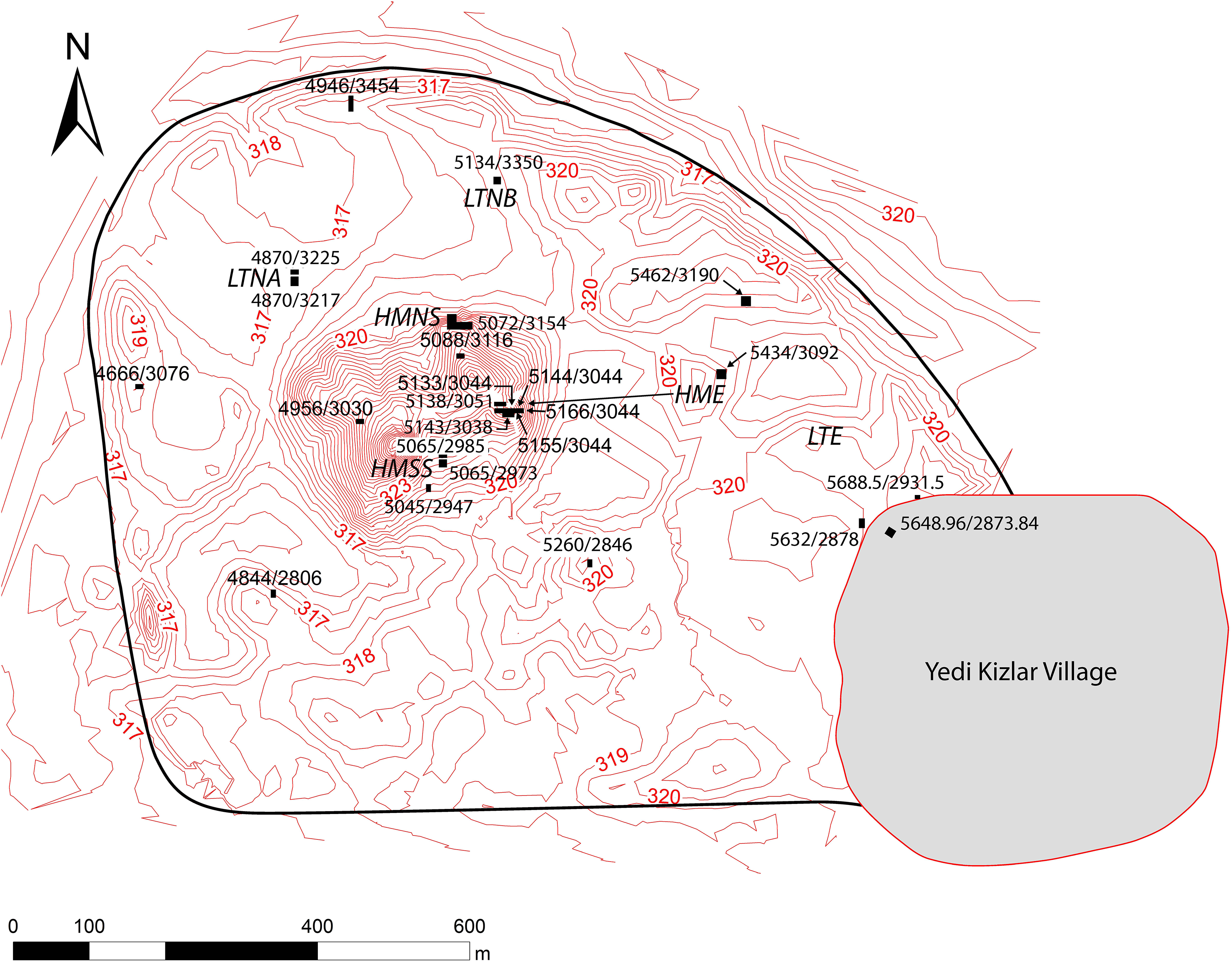
There are two main periods of occupation under investigation at Kurd Qaburstan. The earlier is the Middle Bronze Age (MB) (earlier second millennium B.C.), when the 95-hectare site was fully occupied and was enclosed by a fortification wall. Because of the site’s large size and monumental architecture in this period, it has been proposed that Kurd Qaburstan was ancient Qabra, capital of the Erbil region in the MB (Ur et al. Reference Ur, Babakr, Palermo, Creamer, Ramand, Soroush and Nováček2012; Schwartz et al. Reference Schwartz, Brinker, Creekmore, Feldman, Smith and Weber2017: 4). After a possible hiatus, the site was occupied in the Late Bronze Age (LB) (mid-later second millennium B.C.), when settlement was concentrated on the high mound and, perhaps, part of the eastern lower town (Fig. 2).Footnote 2
Kurd Qaburstan, with excavation areas indicated
The main goal of the project is the investigation of northern Mesopotamian second millennium B.C. urbanism through study of a city whose MB remains are discernible immediately below the surface.Footnote 3 Among the issues considered are the spatial organization and character of domestic, elite, and public areas and the evaluation of hypotheses concerning “hollow cities,” socio-political heterarchy, and the nature of urbanism after periods of decentralization (Schwartz et al. Reference Schwartz, Brinker, Creekmore, Feldman, Smith and Weber2017).
In 2022, research goals included:
-
1. Continued geophysical survey on the Lower Town and High Mound in order to study the urban layout in the MB period.
-
2. Expanded excavation of large-scale MB architecture on the High Mound North Slope (Schwartz et al. Reference Schwartz, Creekmore, Smith, Weber and Webster2022).
-
3. Expanded excavation of LB residential architecture on the High Mound East (Schwartz et al. Reference Schwartz, Brinker, Creekmore, Feldman, Smith and Weber2017; Schwartz et al. Reference Schwartz, Creekmore, Smith, Weber and Webster2022).
-
4. New exploratory trenches in the Lower Town East where geophysical survey results showed areas of high contrast, possibly indicative of burned or baked brick remains.
-
5. Continued excavation of the MB temple in the Lower Town East (Schwartz et al. Reference Schwartz, Creekmore, Smith, Weber and Webster2022).
Geophysical SurveyFootnote 4
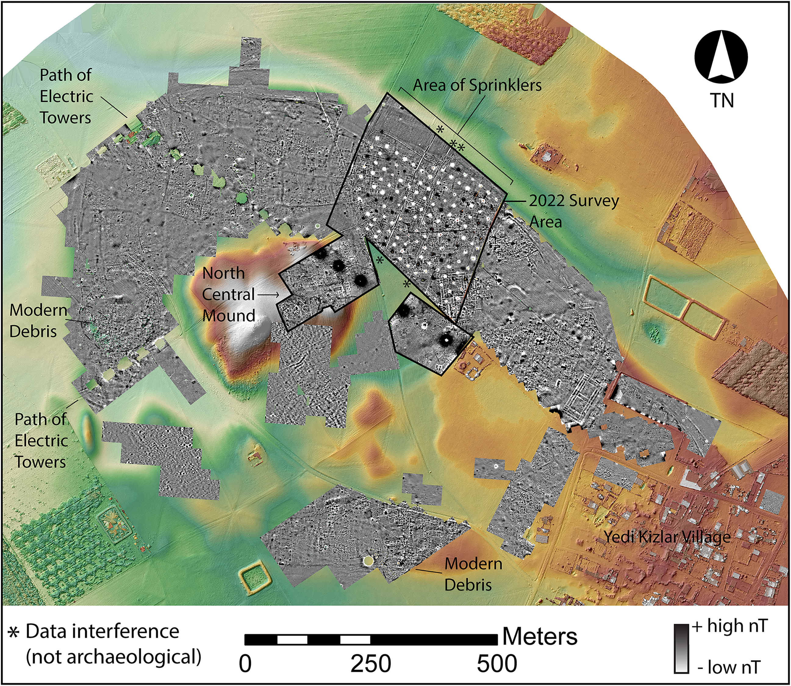
The 2022 magnetometer survey covered c. 13 hectares, including a large area in the north-central portion of the city, part of the field to its south, and the northern portion of the central mound (Fig. 3).Footnote 5 It was challenging to survey the north-central area because it contains regularly spaced irrigation sprinkler heads standing about 1 m above the ground surface. Although the buried pipes that linked the sprinklers were fortunately mostly plastic, the sprinkler heads contained ferrous metal that generated a spotted pattern of large dipoles in the data. In previous seasons, we had worked with a hand-carried Bartington grad 601 fluxgate gradiometer, but in 2022 we utilized a SENSYS MXPDA gradiometer push cart.Footnote 6
Digital elevation model (DEM) and magnetogram with significant modern disturbances marked. Linear north-south black/white stripes, marked with asterisks, are data interference, not archaeological or topographic features. The image is a composite of different survey data sets processed to slightly different parameters, thus the nT scale is generalized to high/low values. DEM in this and subsequent figures courtesy of Jason Ur
The steep slopes and persistent erosion of multi-period strata make it difficult to obtain coherent plans of buildings or features on the northern portion of the central mound. The data here contain a few linear features that we interpret as portions of structures (Fig. 4). Excavations in this area and its vicinity usually revealed LB remains or, rarely, MB architecture directly below the present-day surface, occasionally cut by later period features such as burials (Schwartz et al. Reference Schwartz, Creekmore, Smith, Weber and Webster2022). This indicates that the near-surface architecture in the magnetometer data most likely dates to the LB but might include MB features.
DEM and interpretation of magnetometry data. Streets are black, architecture is white. Only the most prominent features are marked. G# marks possible gates suggested by streets approaching the city wall or structures that may indicate passage. G?x marks possible additional gates suggested by topographical features
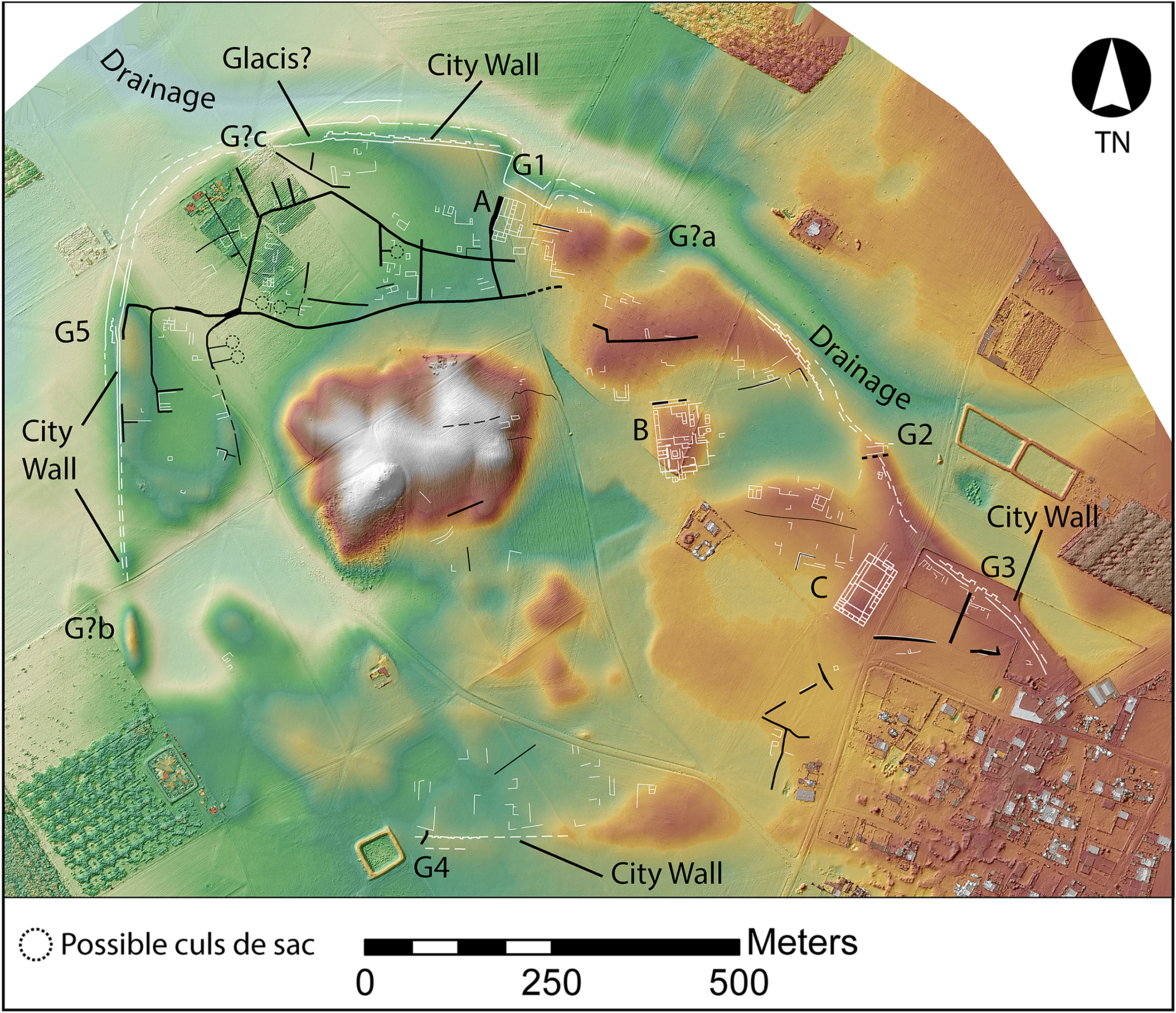
Excavations and surface collections date the extensive lower town to the MB (Schwartz Reference Schwartz, Kopanias and MacGinnis2016; Schwartz et al. Reference Schwartz, Brinker, Creekmore, Feldman, Smith and Weber2017, Reference Schwartz, Creekmore, Smith, Weber and Webster2022; Ur et al. Reference Ur, Babakr, Palermo, Creamer, Ramand, Soroush and Nováček2021). The survey in the large sprinkler field revealed dense architecture, although in many places individual walls are difficult to delineate. The walls are marked by relatively low magnetism, indicating mudbrick construction, and usually encompass smaller rooms or spaces 3–4 m wide. A straight east–west street crosses part of the area, but its connections to streets further west or east are not clear. This street is roughly 1.5–2 m wide and distinguished by higher magnetism, like other streets on the site. Thus, it is likely that the street is paved with potsherds and organic refuse. The street marks the center of an elongated mounded area, which suggests that the mound is comprised of the ruins of structures along the street. Although the mound of the city wall continues into this area from the east, we are not able to trace the wall and its bastions into the sprinkler field. Interference and disturbance from sprinklers and pipe trenches may be to blame. The pipes appear to be laid in trenches about 0.5 m deep that link the sprinklers, and their path unfortunately follows the trajectory of the city wall.
In the southeast corner of the sprinkler field, we identified a very large building that we suspect to be a palace because its size and organization are similar to excavated MB palaces in the region (Fig. 4: Building B; Fig. 5). We mapped the eastern third of this structure in 2017 but were not aware that the rooms we identified were part of a much larger structure until we surveyed the sprinkler field. An excavation unit in the eastern part of the structure revealed features constructed from baked brick and synthetic basalt that indicate industrial activities (see below, Lower Town East, trench 5434/3092). Dated to MB by this excavation unit and surface collections, the building’s size and internal organization are similar to MB palaces across Mesopotamia. Palaces form sprawling complexes that include one or more large courtyards bounded by residences for the royal family and support staff, reception areas, a throne room, chapels or temples, workspaces such as kitchens, and storage rooms. Examples include the MB Western Palace in Area Q at Ebla (Pinnock Reference Pinnock2001: 23), the royal palace of city III and the Little Eastern Palace at Mari (Margueron Reference Margueron2014: 114, 120–121), the Old Palace at Assur (Pedde Reference Pedde and Renger2011), the MB Lower Town Palace at Leilan (Šubat-Enlil) (Ristvet and Weiss Reference Ristvet, Weiss and Eidem2010: xiii–xiv), the Area F palace at Tell Asmar (Ešnunna) (Reichel Reference Reichel2018), and the Old Babylonian palace at Tell al Rimah (Dalley Reference Dalley1984: 24).
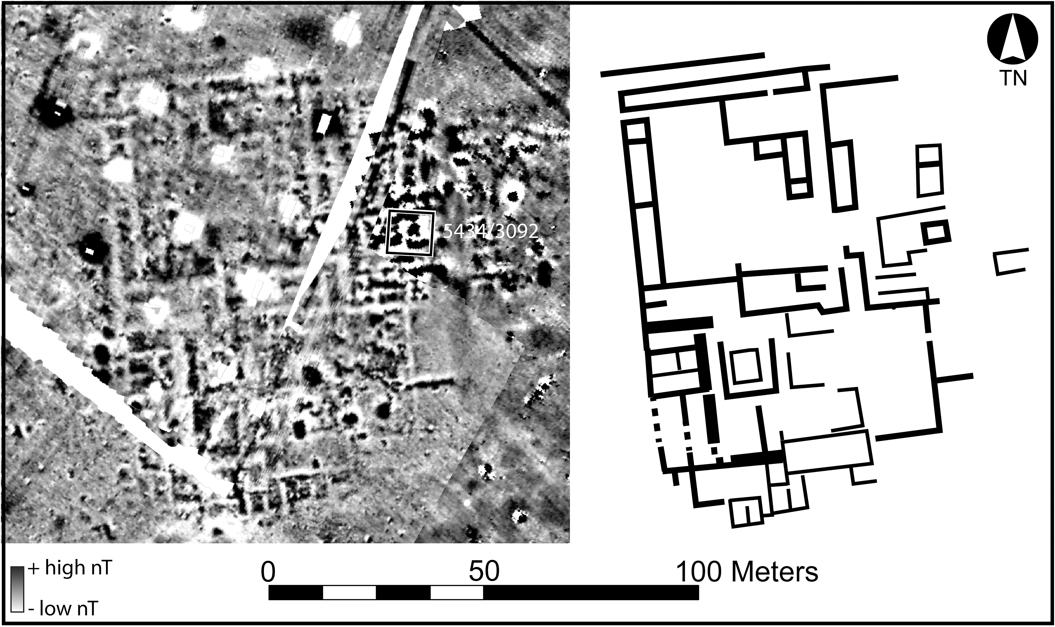
Building B includes a large square space, possibly a courtyard, in its northwest quadrant. However, rooms are built into part of this space, casting doubt on its function or indicating later subdivisions. This is bounded by rooms with dimensions from 3–8 m x 3–10 m. Additional rooms continue to the south and east. Erosion of the eastern edges of the structure notwithstanding, it measures approximately 70 m east–west x 100 m north–south. The walls mostly range from 1–2 m thick and have low magnetism indicative of mudbrick construction. Especially thick walls in the southwest portion of the structure may demarcate important spaces. For example, extra thick walls surround throne room 65 at Mari (Margueron Reference Margueron2014: 114). The extra width in the magnetometer data may also reflect benches, engaged columns, projections, or other decorative elements, as seen in the main court of the MB Temple of Aššur at Assur (Gries Reference Gries, Evans and Rossberger2019: 141), the acropolis temple at Leilan (Weiss Reference Weiss1985), or the MB temple at Tell al Rimah (Dalley Reference Dalley1984: 113–115). Some interior spaces have higher magnetism that may correlate to roof collapse, ash deposits, or baked brick features.
Discussion
The data from the 2022 magnetometer survey support previous work that concluded that the MB city contained densely built architecture. Street patterns indicate a moderate degree of planning that organized urban space into a series of rectilinear blocks of different sizes separated by main streets that generally follow the cardinal directions. The discovery of a possible palace shows that there was significant distance between it and a temple to the east (Fig. 4: Building C), as well as other public buildings presumed to lie beneath later architecture within the central mounds. This spacing may suggest socio-political separation between these centers of power. Building B also sits at the edge of what we interpret as a large open space in a depression to the northeast. Open spaces within cities may serve as gardens, livestock gathering zones, marketplaces, plazas, seasonal ponds, or waste disposal areas. From this position, Building B had an unobstructed view to the east, where there may be a gate at the base of the open space. The palace also had views to the south and perhaps mirrored the prominence of the temple to the east and other monumental architecture on the high mound.
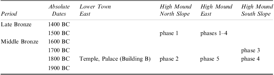
Excavation Results (see Table 1)
LB Domestic Remains and MB Large-Scale Building, High Mound North Slope (HMNS)
In 2017, a large Middle Bronze building was exposed immediately south of what is interpreted as an enclosure wall on the north slope of the high mound (Schwartz et al. Reference Schwartz, Creekmore, Smith, Weber and Webster2022: fig. 15). In 2022, further excavations included excavations to floor level in area 7 (trench 5072/3154), and an expansion of the exposed building to the southwest in area 7 (trench 5074.5/3144) and to the east in areas 8–9 (trenches 5083/3154, 5089/3154) (Fig. 6). The aim was to continue investigation of the building and better understand its character and function.
Kurd Qaburstan chronology; preliminary absolute dates and chronological relationships between excavation areas
High Mound North Slope, MB building, with trench numbers indicated

Below the present-day surface in the eastern extension of the excavated area (trenches 5083/3154 and 5089/3154) was Late Bronze Age occupation equivalent to phase 1 of the 2017 excavations. As in 2017, the remains were primarily characterized by clusters of baked bricks, grinding stones, synthetic basalt fragments, and potsherds. Two sub-phases were noted. In trench 5083/3154, the later of the two phases had a food preparation area consisting of grinding stones, pestles, baked brick door socket fragments (reused as mortars?), synthetic basalt fragments, and a near-complete cooking pot (Fig. 7: 3) resting on a mud surface. In trench 5089/3154 was a large block-rim bowl (Fig. 7: 4) sunk below a floor surface and inside an enclosure of baked brick fragments.
Middle Bronze (1–2) and Late Bronze (3–8) ceramics
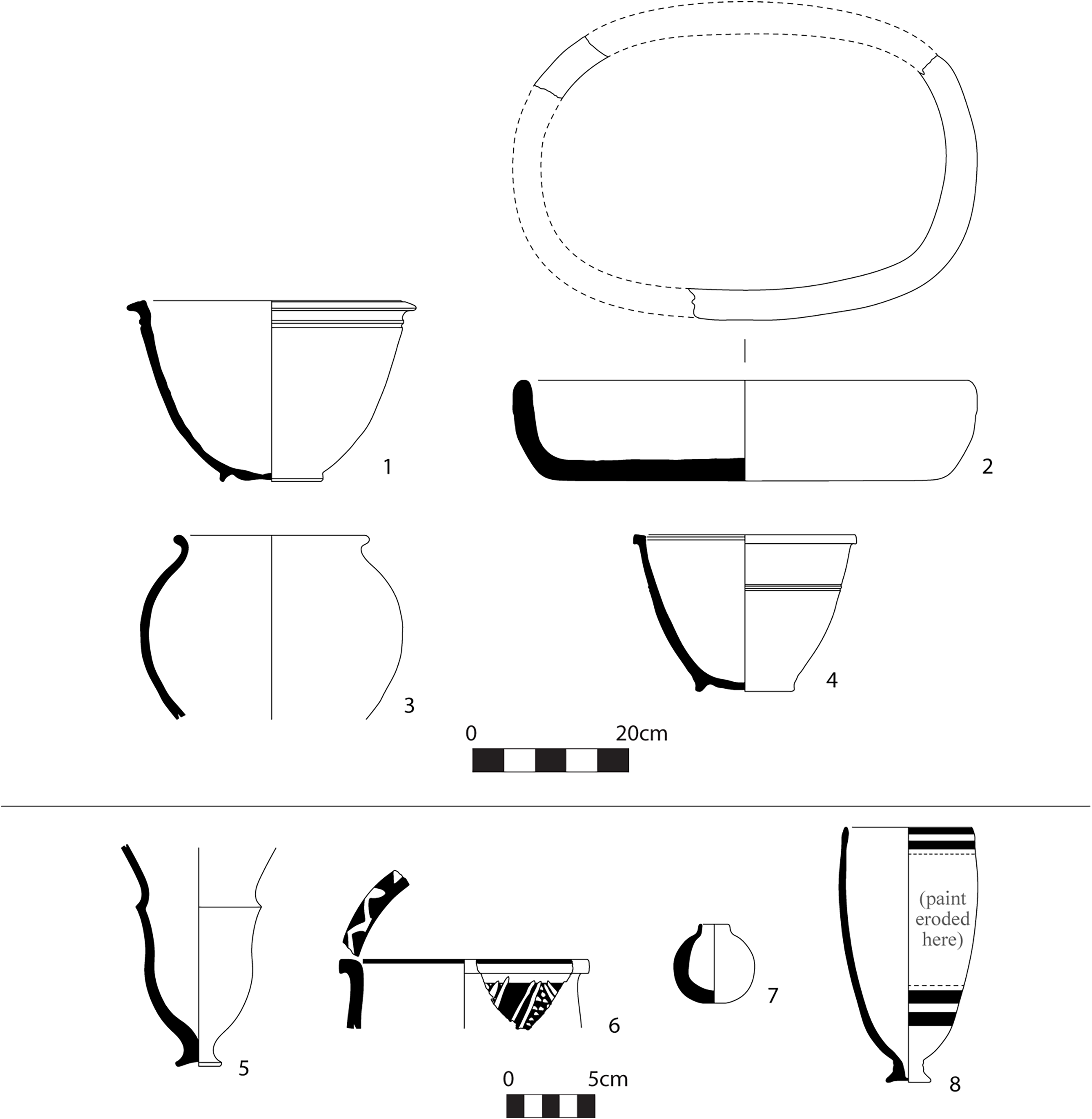
An adult pit burial (5083/3154-011) was identified in the northwest corner of trench 5083/3154. The body was oriented east-west, head facing south, and flexed. West of the skull was a painted Younger Khabur Ware goblet (Fig. 7: 8), while a bronze hoop earring was found in situ on the skull, and an agate pendant under the chin. Other items in the grave included a small bottle (Fig. 7: 7), a bronze ring, and a sheep/goat jaw northwest of the skull.Footnote 7
Another apparent pit burial (5074.5/3144-004), located in the southeast corner of trench 5074.5/3144, was so identified because the oval pit contained a complete pottery vessel, a collection of faience and shell beads, a bronze ring, and a bronze dagger all distributed on a lime plaster surface. However, no human bones were found.
The dagger (KQ 22 M-001) is a cast hilt type with ridges along the hilt and three ‘pinched’ widenings of the hilt found at the pommel, between the pommel and the blade, and at the juncture with the blade (Fig. 8). Given its ridges, which are present on both sides, the hilt was presumably inlaid with ivory, bone, or wood. Two rivets to attach the inlay to the metal are evident on one side of the weapon. Cast hilt daggers were employed across Western Asia from the early/mid-second millennium to the early first millennium B.C. (Shalev Reference Shalev2004: 41–43). Noting the technical requirements and elaborate design of cast hilt daggers, Schulz (Reference Schulz2014: 58) suggests that they were associated with persons of higher social rank. At 23.8 cm, the KQ 22 M-001 blade is relatively short compared to similar blades elsewhere in Western Asia (Schulz Reference Schulz2014; Shalev Reference Shalev2004). The hilt length is 8.5 cm (=36% of the dagger length) and has a maximum thickness 0.6 cm, while the maximum width of the blade is 1.7 cm and maximum thickness 0.7 cm. The width of the pommel is 0.8 cm.
LB bronze dagger, High Mound North Slope

Comparing KQ 22 M-001 with LB daggers from the Levant, similarities can be cited with Shalev’s type 7, especially 7E and 7F (Shalev Reference Shalev2004: 46–49; see also type F in Schulz Reference Schulz2014: 49–51), but those types lack the widening of the hilt between the pommel and the blade that is found on the Kurd Qaburstan example. Such a widening is observable in Shalev’s type 7G, but the illustrated example, found at Akko, has a semicircular pommel rather than a mildly curving one as in KQ 22 M-001 (Shalev Reference Shalev2004: plate 17, no. 157; see also Schulz Reference Schulz2014: 51–52, pl. 14, D 173, type G1). Daggers of the aforementioned types are attested in the Levant from the 16th to the 12th centuries B.C. Parallels with three widenings of the hilt also include an example from LB Tall Munbaqa on the Syrian Middle Euphrates (Czichon and Werner Reference Czichon and Werner1998: 17, pl. 52, 112) and Calmeyer’s Luristan group 31A (Calmeyer Reference Calmeyer1969: 60, fig. 56), a type dated to the Kassite-Isin II period (1200–1060 B.C.).Footnote 8
The earlier sub-phase of the LB phase 1 had only minimal remains. These mainly consisted of small work areas indicated by clusters of baked bricks or fragments lying flat found together with basalt or synthetic basalt grinding stones and baked brick door socket segments (recycled mortars?).
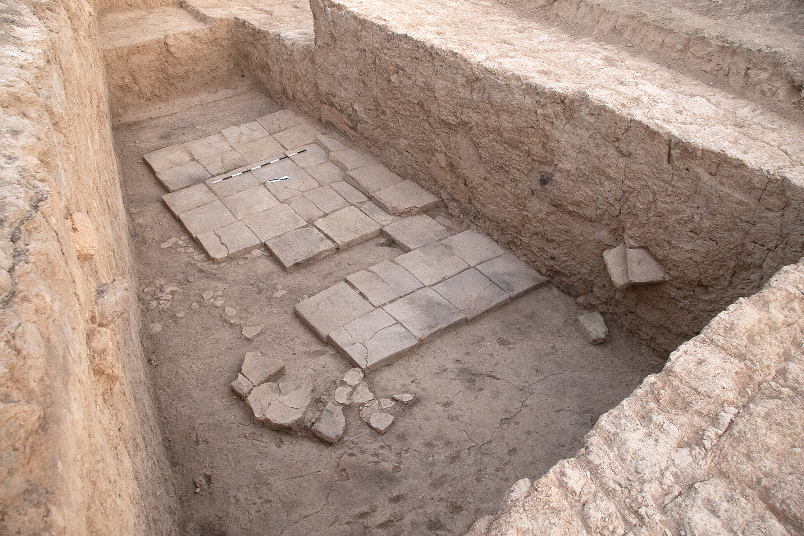
The large MB building first identified in 2017 was encountered in phase 2, below the LB phase 1 occupation (Fig. 6). This structure had walls three mudbricks wide (1.4 m), preserved as high as 1.6 m and coated with gray mud plaster 2–4 cm thick (Fig. 9).Footnote 9 A baked brick surface with 36 bricks, each 40 cm square, formed the northwest part of the floor in area 7. In areas 8 and 9, a smaller similar feature was in association with a jar in situ at its southeast corner. Otherwise, the floors were composed of mud plaster. Evidence of reed matting on the floor was detected in area 8 (Fig. 10).
High Mound North Slope MB building, area 7, looking northwest
Reed matting on floor, area 8, High Mound North Slope MB Building
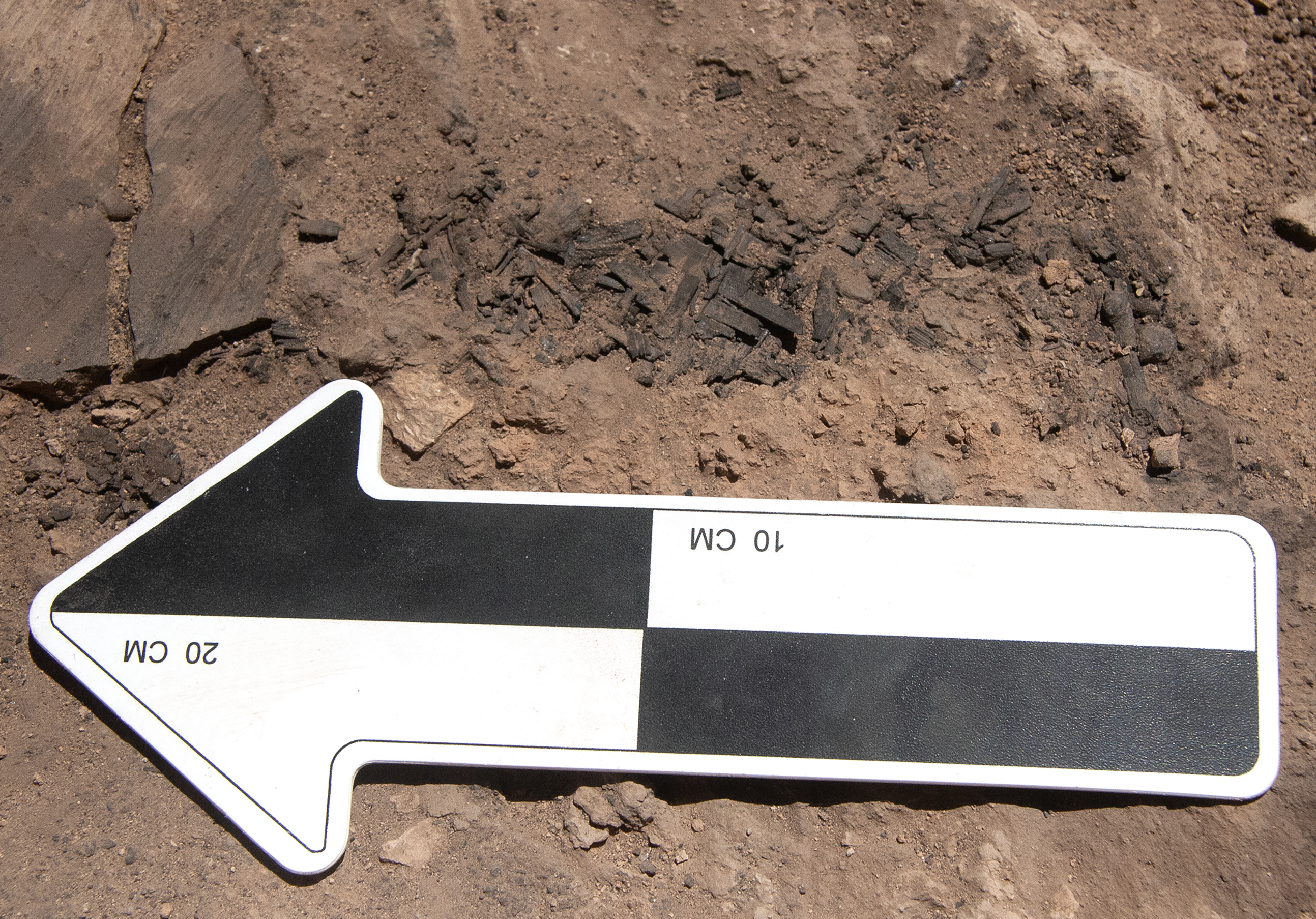
Segments of burned wooden and mud roofing material and other charred debris were noted throughout the building, and the face of the east wall of area 7 displayed evidence of burning. Despite this indication of a conflagration, very little artifactual material was in situ on the floors, apart from sherds from large storage vessels and a complete large bowl (Fig. 7: 1). Perhaps the contents of the building had been rescued prior to the fire or were removed by enemies before they set the building alight. The baked brick floors and thick walls suggest a public or elite character for the edifice.
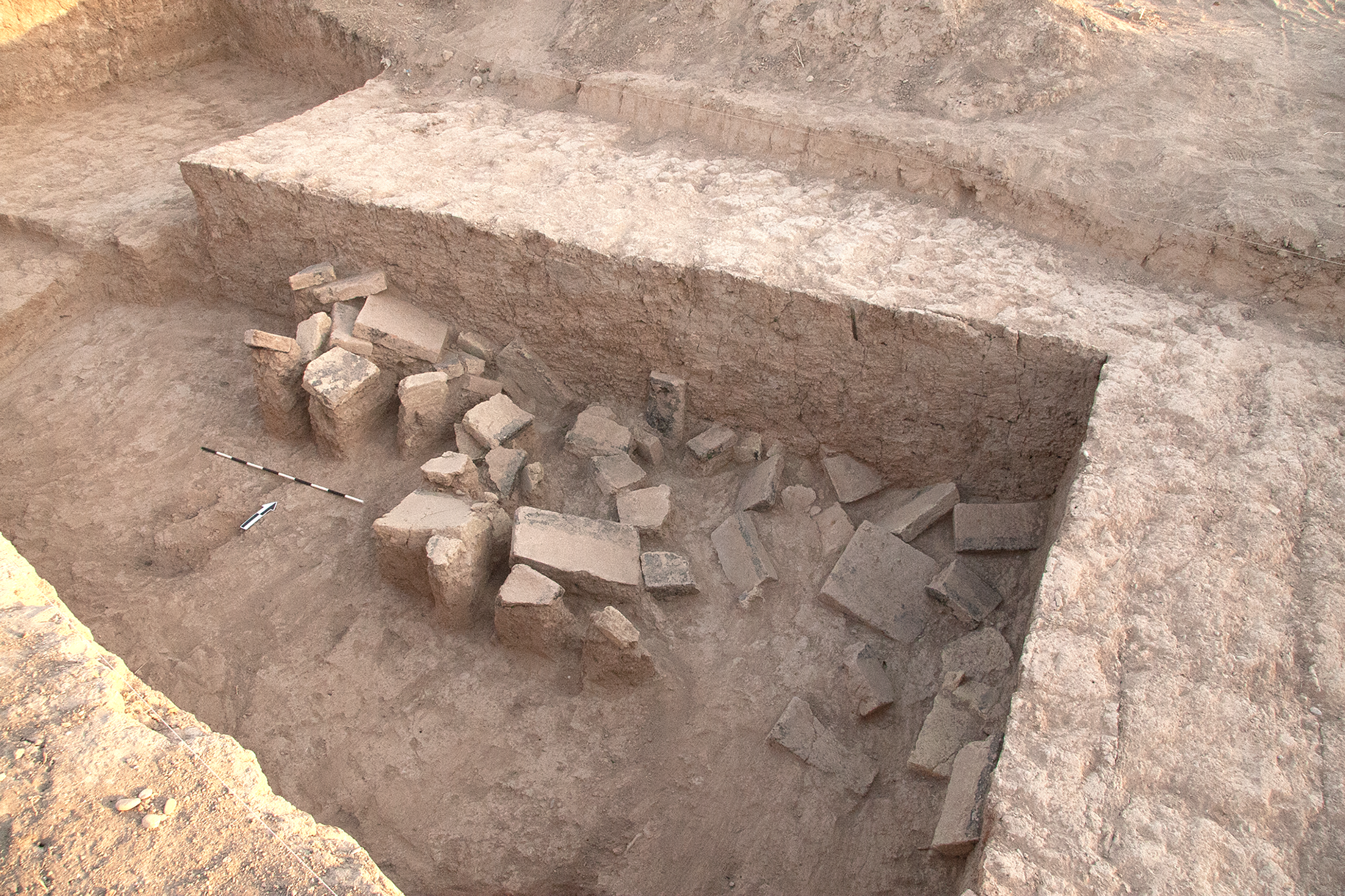
A curious aspect of the debris filling the northeast part of room 7 was a 1.8 m-high tumble of numerous baked bricks and fragments partly coated with bitumen or lined with bitumen mortar (Fig. 11).Footnote 10 The tumble, whose top was c. 2 m above the floor, sloped down from southwest to northeast until c. 20 cm above the floor, with several bricks flat against the north and east walls of the room. At first, it was thought that the bricks fell from an adjacent structure (basin?) to the south, but no evidence of such architecture was detected by the excavations in the southern part of areas 4 or 7. Alternatively, they may be fallen remnants of a floor from an upper story, perhaps a localized surface like that of the northwest part of area 7 noted above (cf. Margueron Reference Margueron1982: 295: figs. 218–219; Parrot Reference Parrot1958: 145–146).
Baked brick tumble, area 7, High Mound North Slope MB Building, looking northwest
LB Industrial Features and MB Large-Scale Architecture, High Mound East (HME)
To continue the investigation of well-preserved LB remains on the high mound, a 10 x 6 m trench (5143/3038) was excavated south of trenches 5133/3044 and 5144/3044 that were excavated in previous seasons on the High Mound East (Schwartz et al. Reference Schwartz, Creekmore, Smith, Weber and Webster2022: fig. 18). Four LB phases were identified, the three latest of which appear to correspond to the phases 1–3 identified in earlier excavations (Schwartz et al. Reference Schwartz, Brinker, Creekmore, Feldman, Smith and Weber2017, Reference Schwartz, Creekmore, Smith, Weber and Webster2022).
Attributable to phase 1 was an infant burial in the eastern part of the trench (5143/3038-015). This feature consisted of a skeleton interred inside a clay receptacle adjacent to a large inverted ceramic jar missing its rim. The body was in a flexed position, with the head facing west. Another burial that might be assigned to phase 1 was an adult pit grave protruding from the south baulk (5143/3038-035). In this burial, the flexed body was oriented east–west on a lime plaster surface, with the head on the west, facing south. A carnelian bead at the back of the neck was the only evidence of grave accompaniments. Note that two pit burials were excavated in this phase to the north in earlier seasons (Schwartz et al. Reference Schwartz, Brinker, Creekmore, Feldman, Smith and Weber2017).
In phase 2, against the north edge of the trench was a lime-plastered baked brick platform or floor one course high and c. 2.2 x 1.3 m in area (3 x 5 bricks, each 40 cm square) sloping down to the east and north (Figs. 12–13). The feature was lined with vertical baked bricks on its north and west edges, while a lime-plastered baked brick drain, c. 0.3 m wide, sloping down to the north appended its eastern edge. A bronze ring and a near-complete button-based goblet with pinched carination similar to examples otherwise mainly attested at Nuzi strata III-II were associated with this feature (Fig. 7: 5; Starr Reference Starr1937: pl. 77H, N, P, S; pl. 78A). This ceramic type is otherwise rare or absent at Kurd Qaburstan.
Baked brick platform and basin, High Mound East, LB phase 2, looking south

High Mound East, trench 5143/3038, MB and LB features; north is at bottom
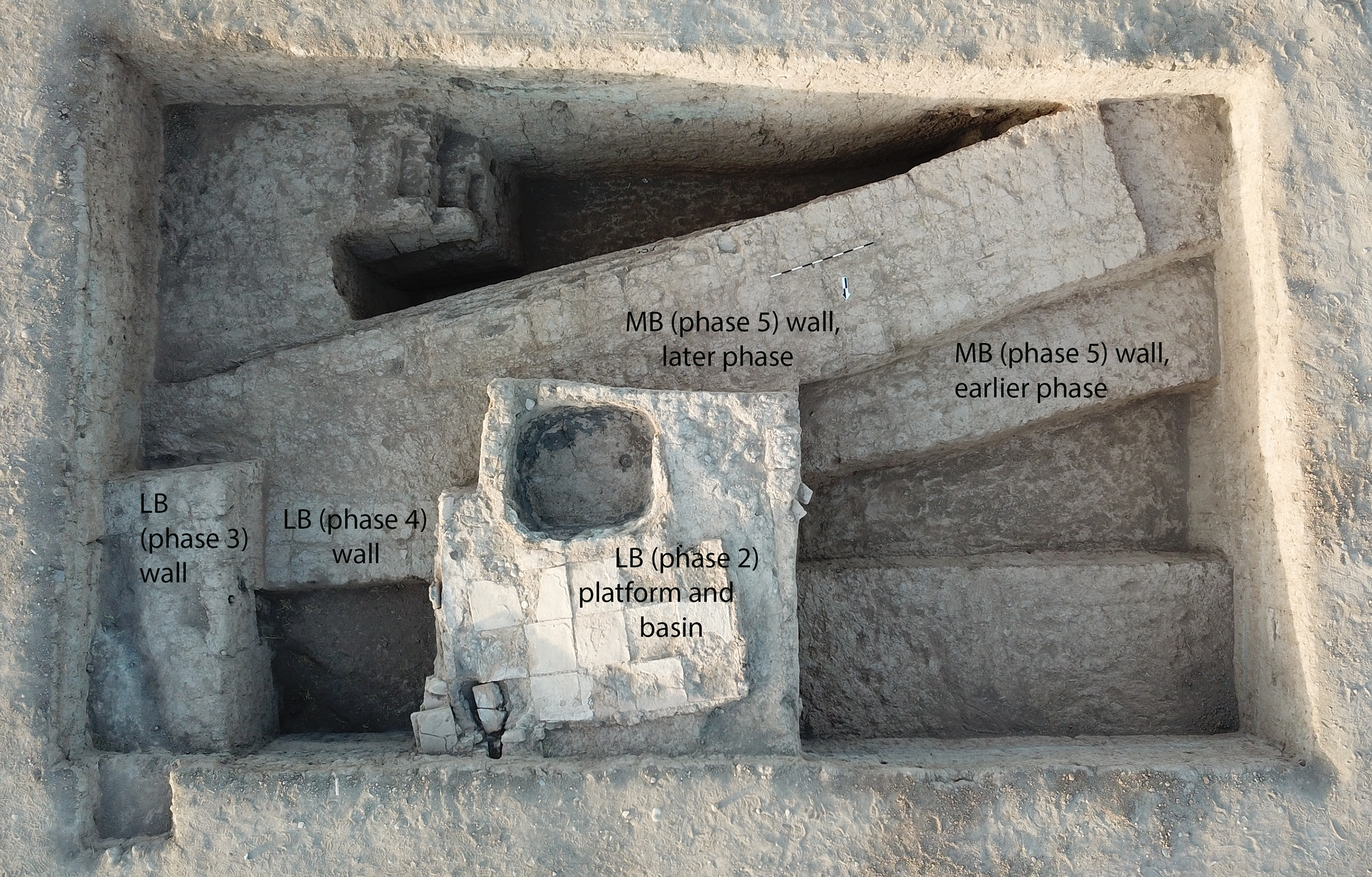
Adjoining the baked brick platform to its south was a lime- and bitumen-plastered oval pit or basin c. 1.4 x 1.1 m in area, whose north and west edges were lined with vertical baked bricks. Debris inside was ashy and contained occasional fragments of slag. To the south of the basin was a large pit with ashy debris and some slag that also yielded one of the rare sherds of Nuzi Ware identified at Kurd Qaburstan (Fig. 7: 6). Although the sloping baked brick surface recalls the features 1 and 5 identified as baths in the phase 3 architecture excavated to the north in 2014 (Schwartz et al. Reference Schwartz, Creekmore, Smith, Weber and Webster2022: fig. 18), this installation is more likely to be industrial in nature, given its association with a basin with burned contents and, perhaps, the pit with ashy contents.
Below this, Phase 3 included mudbrick architecture in the northern part of the trench consisting of a room located south and southeast of the area 5 bath identified in 2014 (Schwartz et al. Reference Schwartz, Brinker, Creekmore, Feldman, Smith and Weber2017: fig. 18).Footnote 11 The eastern part of the room was filled with ashy lenses. In the northwest corner of the trench, a mudbrick wall protruded from the baulk, perhaps an east wall for phase 3 room 3 (Schwartz et al. Reference Schwartz, Brinker, Creekmore, Feldman, Smith and Weber2017: fig. 18). Integrated with the mudbricks in one course of this wall were two baked bricks, a practice also observed in LB remains to the north excavated in previous seasons. No LB architecture was evident in the southern part of the trench in phase 3.
Architectural remains in the earliest LB phase, phase 4, were only minimally documented. In the northeast part of the trench was an east-west wall of two mudbrick rows cutting into the MB architecture below (Fig. 13), part of a structure that had been modified or removed by phase 3 construction. In the west baulk stratigraphic section of the trench, a wall preserved up to five courses was visible, implying the presence of architecture to the west of the trench, as had been the case in phase 3.
MB architecture of substantial scale was identified in phase 5. This consisted of a thick mudbrick wall with two apparent phases of construction, the earlier and wider of the two being five brick rows wide (c. 2.6 m) and the later three rows wide (c. 1.5 m) (Fig. 13). The southern side of this thick wall had a well-preserved mud plaster face and was preserved at least 2 m high; an associated surface was not reached. Evidence of a cross-wall associated with the later phase of the thick wall was found on the west, with burned mudbrick segments in the debris against its upper courses. In the soil south of the thick wall, sherds or other artifacts or ecofacts were very rare. The same was true of the area north of the wall, which had hard brown bricky collapse. This wall appears to have been part of a large building still to be explored.
MB Remains, Lower Town East (LTE), Trench 5462/3190
In the 2017 magnetometric survey results, Andrew Creekmore identified two areas in the Lower Town East with high contrast results possibly suggestive of burned or baked brick architecture or well-preserved mudbrick architecture. In 2022, we opened two 10 x 10 m trenches to investigate each of them.
In the northern trench 5462/3190, the remains of a single MB phase were investigated below the present-day surface. A square baked brick platform or surface was located in the center of the trench, measuring four by four bricks (each 37–38 cm square). To its east and south were clusters of sherds from four or five large storage jars with thick ledge rims and rope appliqué on their bodies.
MB “Palace,” Lower Town East (LTE), Trench 5434/3092
Trench 5434/3092 is the southern of the two excavated trenches with high magnetometric contrasts. After the collection of geophysical data in 2022 discussed above, it became apparent that this trench was located near the eastern edge of Building B, a possible palace (see Fig. 5). As excavated in 2022, trench 5434/3092 yielded evidence from a single Middle Bronze phase below the modern surface (Figs. 14, 15).
MB features, Lower Town East, trench 5434/3092; north is at top

MB features, Lower Town East, trench 5434/3092
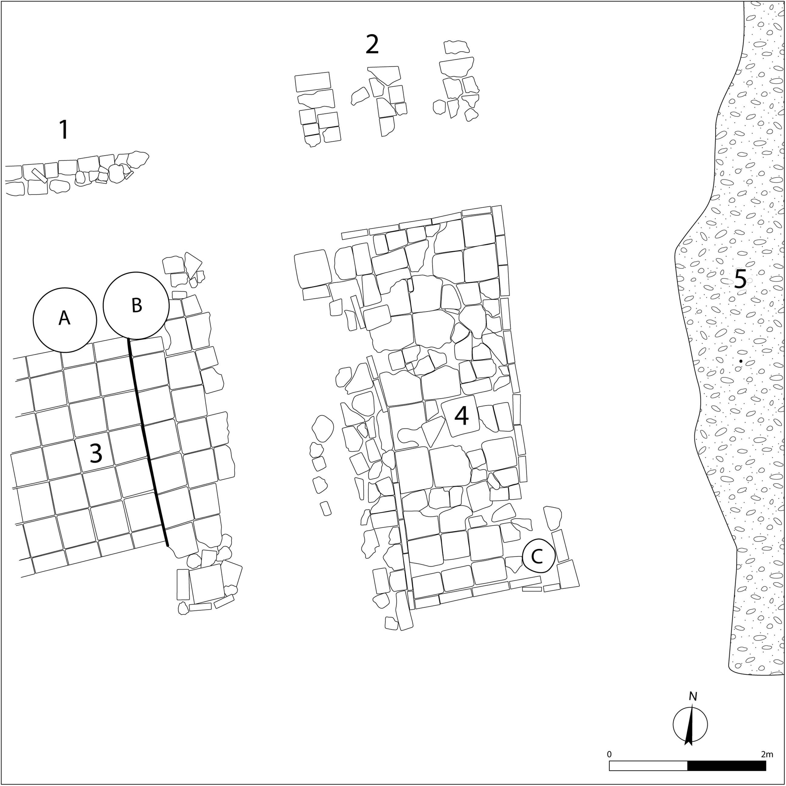
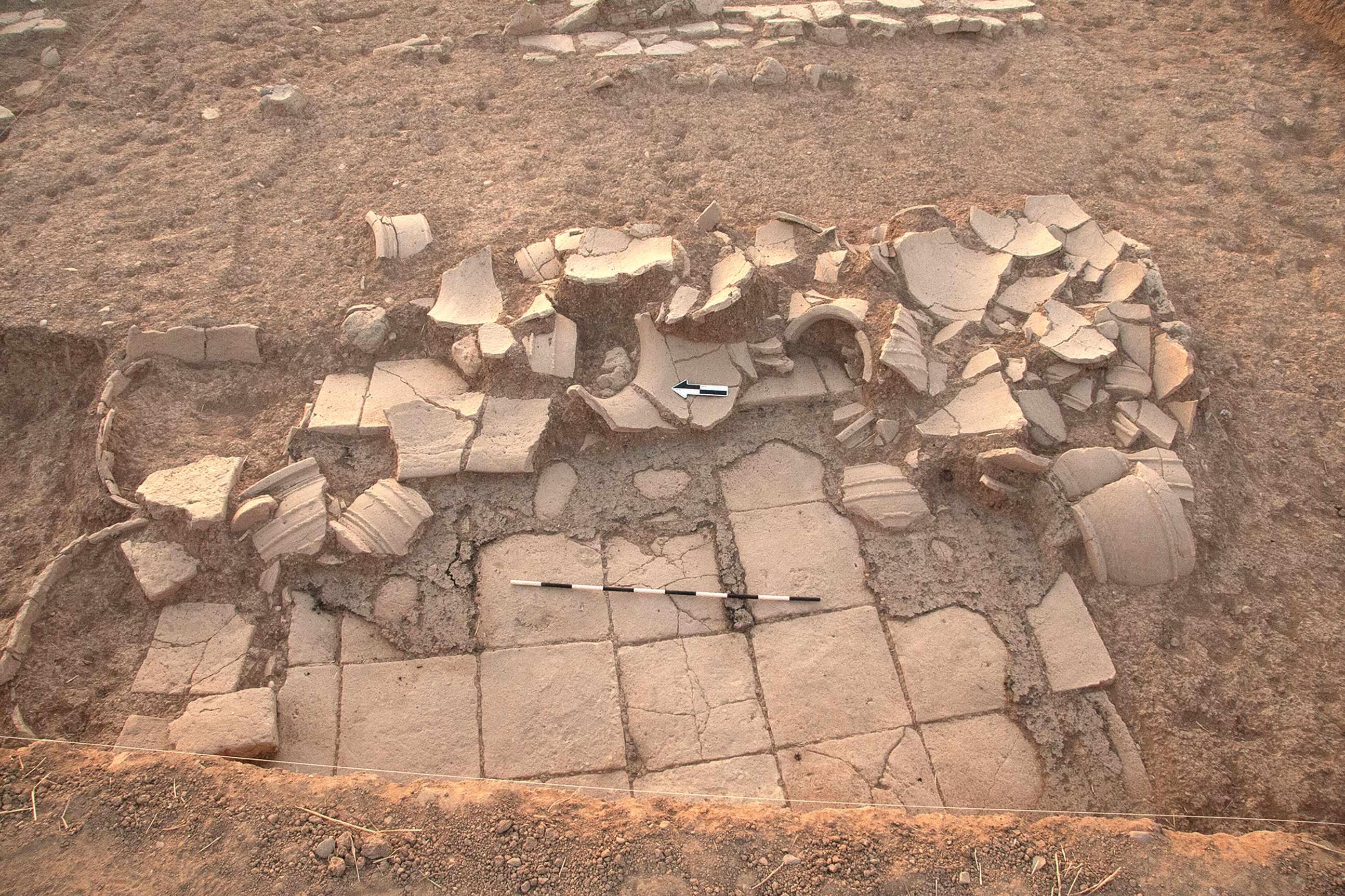
Two main architectural features were identified. In the west was feature 3, a baked brick platform or surface one course high (2.5 x minimum 2.7 m, bricks 42 cm square) coated with bitumen (Fig. 16). Its western extent was one course high and sloped down to the west, while its easternmost three rows were two courses high and sloped down to the east. Numerous sherds from large storage vessels were scattered on top of the baked brick surface, while immediately adjacent to its north were the lower bodies of two large storage jars. The latter vessels had thick ledge rims and appliqué bands, the latter either rope appliqué or plain bands, and perforated bases. It is likely that at least some of the sherds scattered on the platform derived from these two jars.Footnote 12 However, a square baked brick structure at the southeastern corner of feature 3 probably functioned as the base for an additional large vessel. Given its bitumen coating, the baked brick feature 3 must have been used for a function that involved spillage of liquids, ostensibly the substances contained in the three vessels that were part of the structure.Footnote 13
Feature 3, Middle Bronze, trench 5434/3092, looking east
Found inside the western storage jar were four complete or fragmentary baked bricks. One of the fragments (34 x 20 x 8 cm)Footnote 14 had a board game incised on its surface, a procedure that took place at some point after the firing of the brick (Fig. 17). The game is identifiable as the ‘Game of 20 Squares’, whose best-known example derives from the Ur Royal Cemetery but is attested throughout the Bronze and Iron Age Near East (Crist et al. Reference Crist, Dunn-Vaturi and de Voogt2016; Finkel Reference Finkel and Finkel2007). Early second millennium B.C. Mesopotamian examples are documented at Mari, Tell as-Sib in the Hamrin region, and Uruk and Abu Hatab in southern Mesopotamia (de Voogt et al. Reference de Voogt, Dunn-Vaturi and Eerkens2013: fig. 1, table 1). Like the Kurd Qaburstan game, the examples from Mari, which derived from four different rooms in the Zimrilim palace, were incised on baked bricks, most of which were in situ in the baked brick floors or thresholds (Parrot Reference Parrot1958: 12–13, 182–183, 247, 275).Footnote 15
Baked brick with incised board game, Middle Bronze, trench 5434/3092
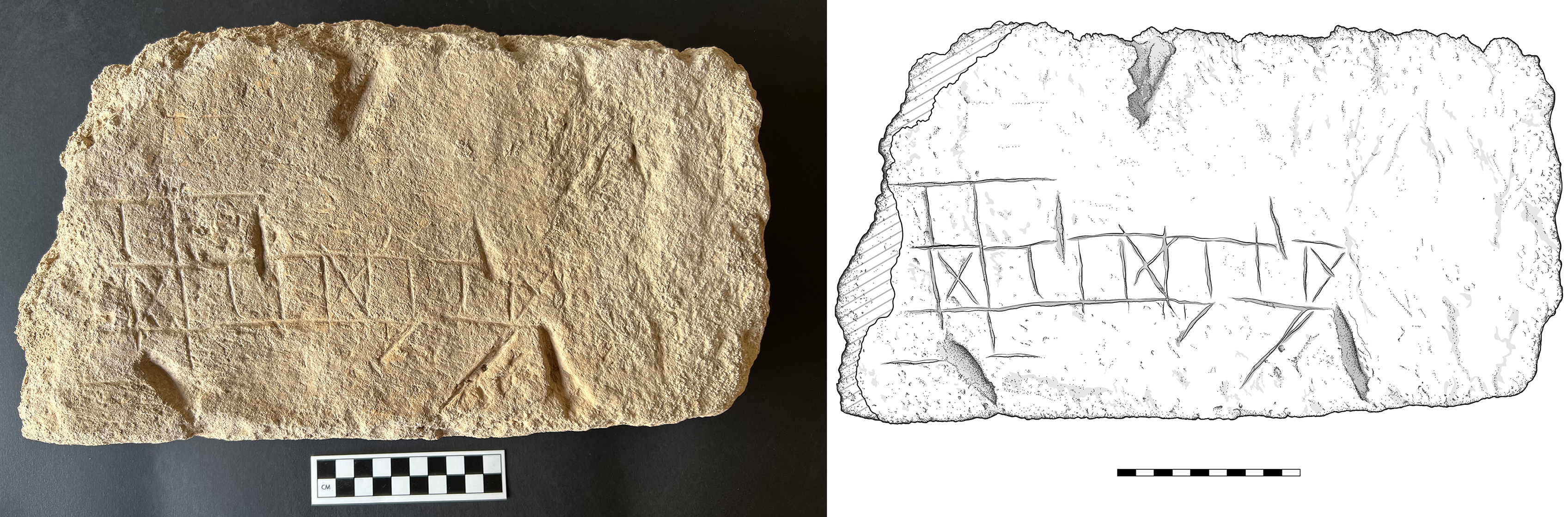
As with other second millennium B.C. examples, the Kurd Qaburstan board is of the ‘head and tail type’ which usually consisted of a ‘head’ of three x four squares and a ‘tail’ of a single row of eight squares extending beyond the middle row of the head (Crist et al. Reference Crist, Dunn-Vaturi and de Voogt2016: 83). As is often the case, the Kurd Qaburstan example has several squares marked with an “X” in the middle row (squares 8, 12 and 16; cf. Crist et al. Reference Crist, Dunn-Vaturi and de Voogt2016: 84, fig. 4.3 for numbering). Although the left end of the head no longer survives, the top and bottom leftmost squares probably were also marked with X’s.Footnote 16 The person who incised the current game extended the top line of the head unnecessarily far to the right. Of uncertain significance are the two diagonal lines incised in the clay below the four rightmost squares of the tail (numbers 13-16). Also of unclear purpose are the five large gouges evident on the surface of the brick, which were made at some point prior to the brick’s recovery in 2022.Footnote 17
North of feature 3 was a narrow wall or feature consisting of two rows, one a row of baked bricks sloping down to the north, and the other a row of large sherds and synthetic basalt segments to its south. It is possible that this construction was the foundation for a mudbrick wall or was the facing of a mudbrick wall to its south. In the former case, the superstructure of the wall was presumably missing due to its proximity to the modern surface and the likelihood of erosion or disturbance. But in the latter case, the mudbrick may not have been discernible due to the homogeneity of the soil in this area, a problem endemic to the Kurd Qaburstan Lower Town (Schwartz et al. Reference Schwartz, Creekmore, Smith, Weber and Webster2022). Indeed, mudbrick architecture in this trench was not identified.
A sunken rectangular structure built of baked bricks in the center of the trench was designated feature 4 (ca. 2.3 x 4.6 m) (Figs. 14, 15, 18). The sides of the feature consisted of square baked bricks 40 x 40 cm positioned vertically in a fashion resembling orthostats, with the western side augmented by a wall represented by two preserved courses of baked brick fragments. Slightly to the west of this wall was a short line of synthetic basalt and baked bricks of unclear function.
Feature 4, Middle Bronze, trench 5434/3092, looking southwest
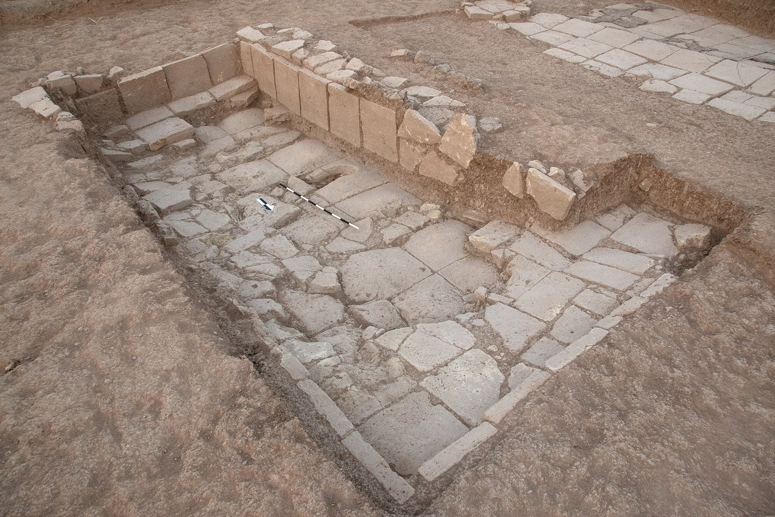
Although the subterranean nature of feature 4 is apparent, no steps or other obvious means of access were ascertained. The floor of the feature sloped down from north to south and was composed of complete and fragmentary baked bricks. In the center of the floor was a large circular indentation probably intended for the installation of a large vessel; the inverted rim of a large storage jar found nearby may have derived from this vessel. In the southeast corner of the structure was a baked brick podium with the lower body of a large storage jar with a perforated base resting on top of it.Footnote 18 Some of the bricks in the floor had a plano-convex shape, with the convex part facing up. Such bricks are known from third millennium B.C. southern Mesopotamia; whether those of feature 4 were extracted from architecture dating to that period or were manufactured for MB use is unknown. One of the plano-convex bricks had a cavity in its center, perhaps indicating an original use as part of a toilet.
The function of the structure is unclear. Partly comparable baked brick semi-subterranean features in the Mari Zimrilim palace were variously interpreted as basins (Parrot Reference Parrot1958: 59; Parrot Reference Parrot1964), grain storage facilities (Parrot Reference Parrot1958: 239), and “piscines” (Parrot Reference Parrot1958: 171).
Three flat baked brick features north of feature 4 sloped up from west to east and might be understood as steps. Against the east baulk of the trench was a sherd- and pebble-paved surface, perhaps a north-south running street.
If the identification of a large-scale building, a possible palace, in the geophysical data is correct, the large storage vessels and specialized features found in trench 5434/3092 might be manifestations of institutional storage activities taking place in that building.
MB ‘Palace’, Lower Town East (LTE), Surface Collection
After the geophysical survey identified a possible palace in this part of the site, a surface collection was conducted in this area to confirm the MB date of the remains and collect more information about the possible nature of the building. The sherds collected were primarily MB in date, although occasional LB block rim sherds were identified.
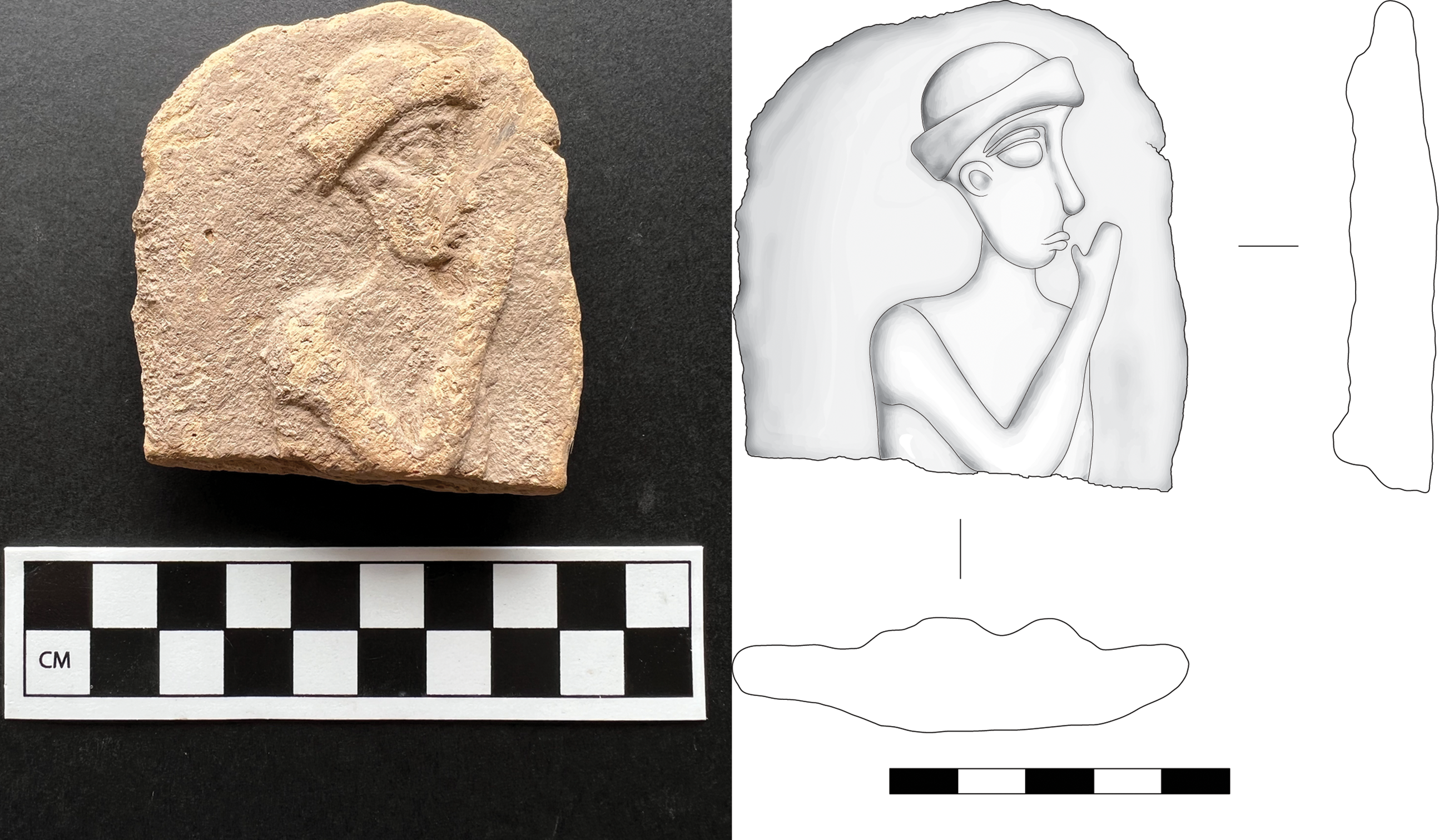
Also found in the surface collection was part of a terracotta MB plaque showing a clean-shaven male figure wearing a brimmed cap (Fig. 19). The figure is represented in profile with the right side facing the viewer and the right forearm raised in a supplicatory gesture. Well-documented in southern Mesopotamian terracotta plaques, this figure is usually interpreted as a worshipper (Barrelet Reference Barrelet1968: 312, 336, pl. 54, 570, pl. 60, 635; Moorey Reference Moorey1975: 84, pl. 20a; Opificius Reference Opificius1961: 230–231). Most of the southern Mesopotamian examples show bearded rather than clean-shaven men. In addition to representations on terracotta, the figure is also attested in southern Mesopotamia on cylinder seals and, most famously, the law code stele of Hammurabi.Footnote 19
Terracotta plaque, MB, surface collection Lower Town East
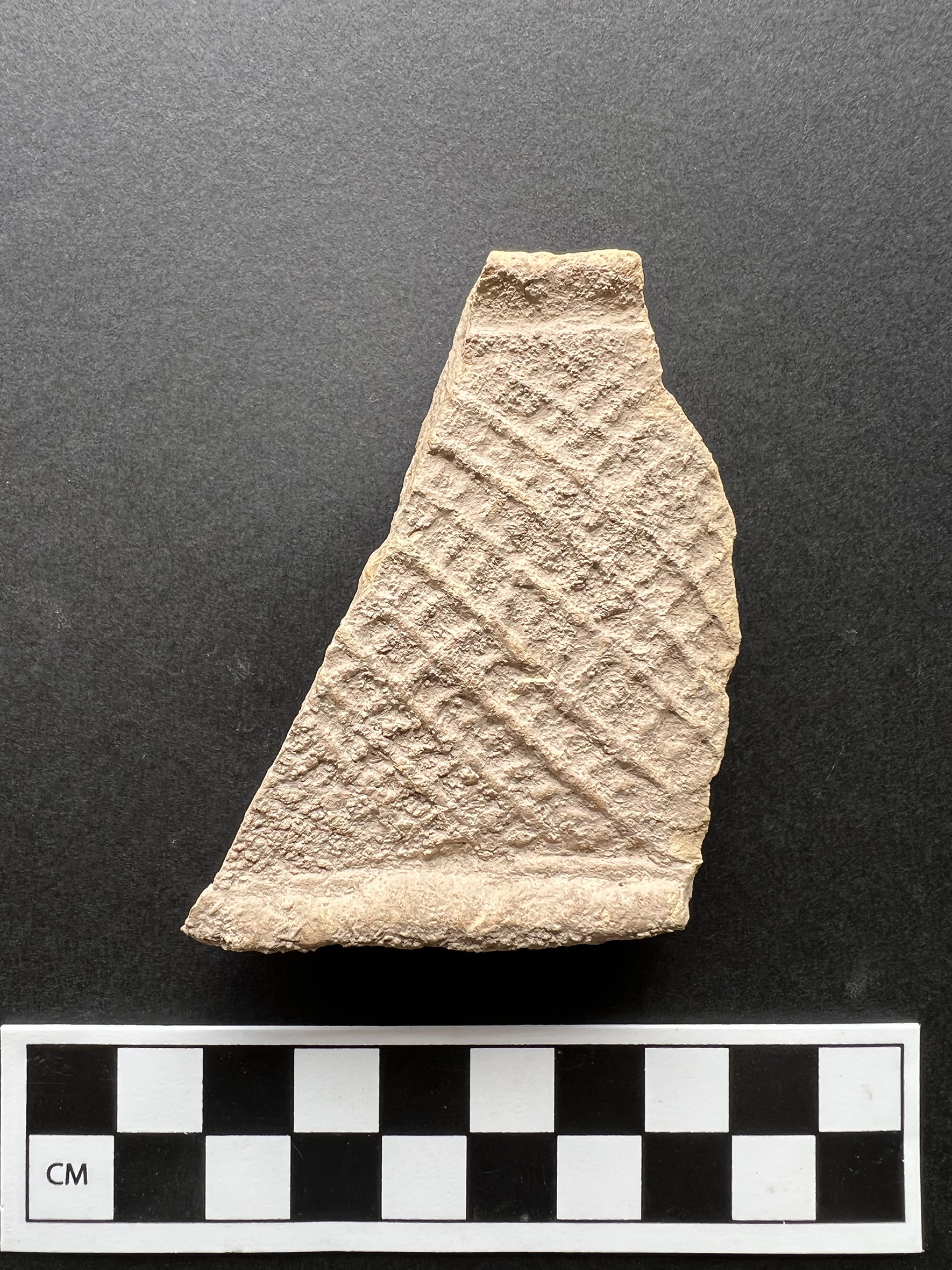
Another surface find from this area was a terracotta model bed fragment (Fig. 20). The mattress, which has a cross-hatched design, is attached to a bar presumably fastened to the bedframe. Relevant comparanda, all of which derive from southern Mesopotamia or Susa, are dated to the early second millennium or late third/early second millennium B.C. (Cholidis Reference Cholidis1992: pl. 22, 20 [Kish]; pl. 24, 41 [Susa]; pl. 28, 71 [Telloh]; pl. 29, 73 [Telloh]; pl. 31, 112; https://www.penn.museum/collections/object_images.php?irn=89032#image3, object 31-43-361 [Ur]).
Terracotta bed model, MB, surface collection Lower Town East
MB Temple, Lower Town East, Trench 5648.96/2873.84
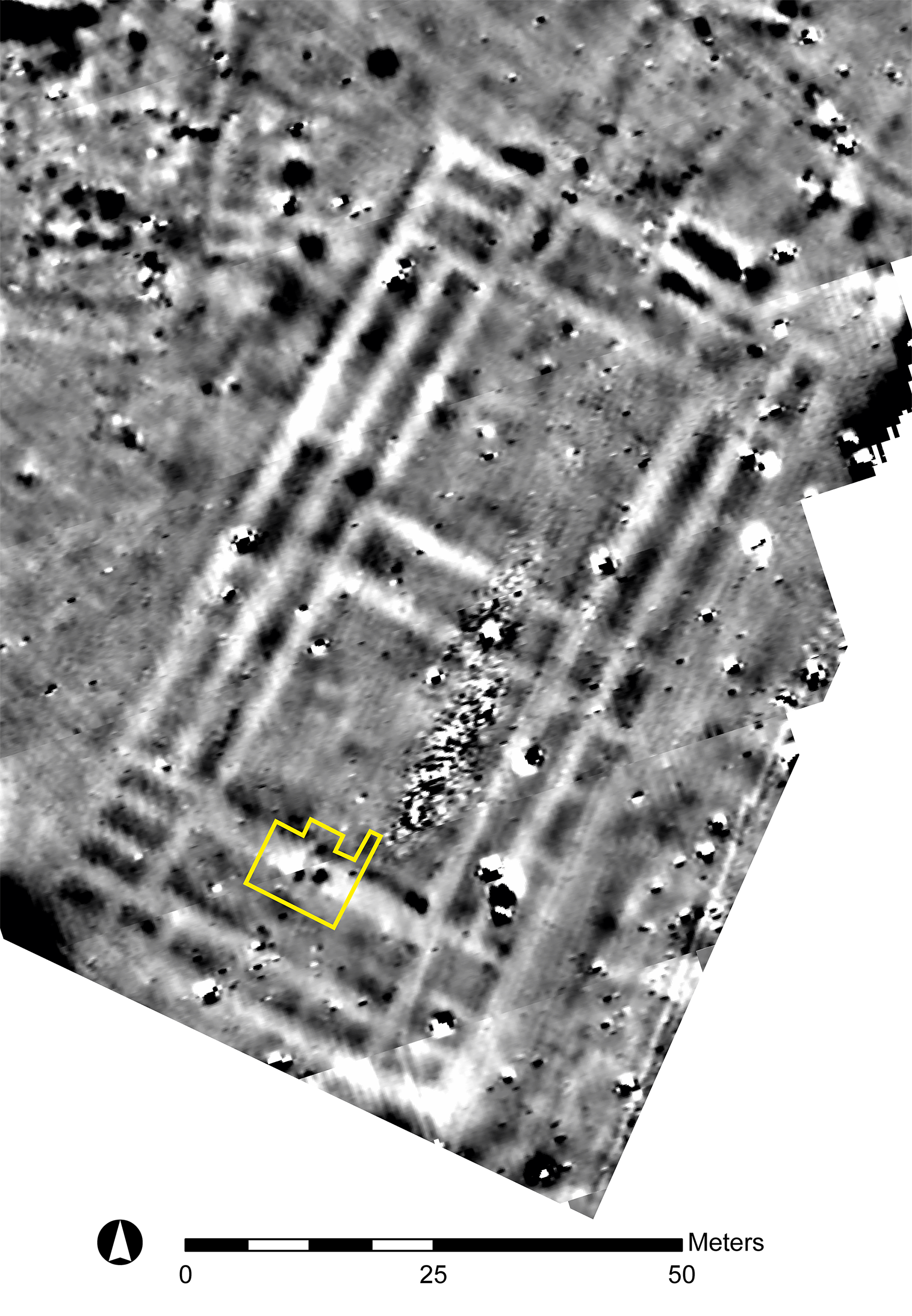
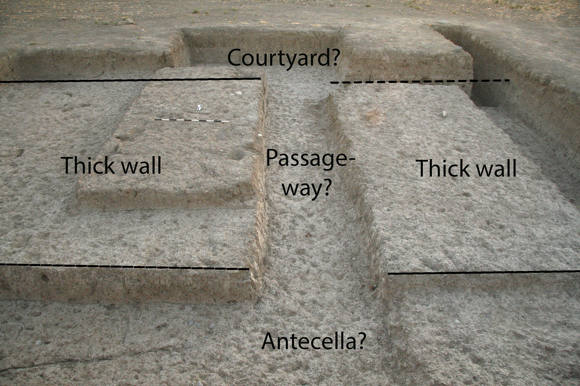
In 2017, Andrew Creekmore had identified a large building interpretable as a temple in the magnetometry results (Fig. 4, Building C), and small-scale investigative soundings were conducted in the same field season (Schwartz et al. Reference Schwartz, Brinker, Creekmore, Feldman, Smith and Weber2017). In 2022, trench 5648.96/2873.84 was opened in the southern part of this building, oriented according to the architecture observed in the magnetometry results (Figs. 21, 22).Footnote 20 The remains below the present-day surface dated to the MB. Excavations here were complicated by the homogeneity of the soil, making it very difficult to recognize mudbrick architecture. However, study of the stratigraphic sections indicated the presence of a thick wall c. 3.75 m wide, bounded on either side by ashy surfaces. Given the geophysical results, we interpret this wall as the south wall of the temple’s southern courtyard. The space north of this wall would therefore be part of the southern courtyard, and the space to the south might be interpretable as an antecella. An apparent narrow passage through the wall, c. 1 m wide, connected the two areas. Artifactual remains were few but included sizeable sherds of large storage vessels with rope appliqué decorations, a large oval tray (Fig. 7: 2), and two bone tool fragments, one a possible awl.
Temple, MB, with location of trench 5648.96/2373.84 indicated on magnetometry plot
Temple, MB, trench 5648.96/2373.84, test trench through wall on east, looking north
Of particular interest were the faunal remains from this trench (see below), which were dominated by bones of young sheep/goat. Such a restriction to a particular age and species suggests a specialized, ritual use that is an accordance with our identification of the building of the temple. Perhaps these remains are evidence of offerings of lambs to the temple deity.
Middle Bronze Age Pottery from the High Mound South Slope: A Typological and Quantitative Study
This section of the report presents the MB pottery excavated in trench 5065/2985 on the High Mound South Slope (Schwartz et al. Reference Schwartz, Creekmore, Smith, Weber and Webster2022: 202–205), studied in 2022 by Lisa Cooper.Footnote 21 Of particular focus is a representative assemblage of pottery from two consecutive occupation phases. Employing a quantitative study, the area was deemed to have the potential to help refine the MB relative ceramic chronology for the Erbil plain, which remains insufficiently understood.
Four occupation phases distinguish trench 5065/2985: phase 1 (Islamic), phase 2 (Achaemenid), and phases 3 and 4 (MB). The later MB phase 3 had possible open-air working surfaces and pebble surfaces, while the earlier MB phase 4 comprised a set of rooms (Schwartz et al. Reference Schwartz, Creekmore, Smith, Weber and Webster2022: fig. 17). Taken together with the remains from trench 5065/2973 to the south excavated in 2014, the High Mound South Slope MB occupation appears non-elite and domestic in character, including the processing and consumption of foodstuffs. What follows here is a presentation of the principal vessel types recognized from phases 3 and 4, with comparison to pottery elsewhere in Kurd Qaburstan and other sites.
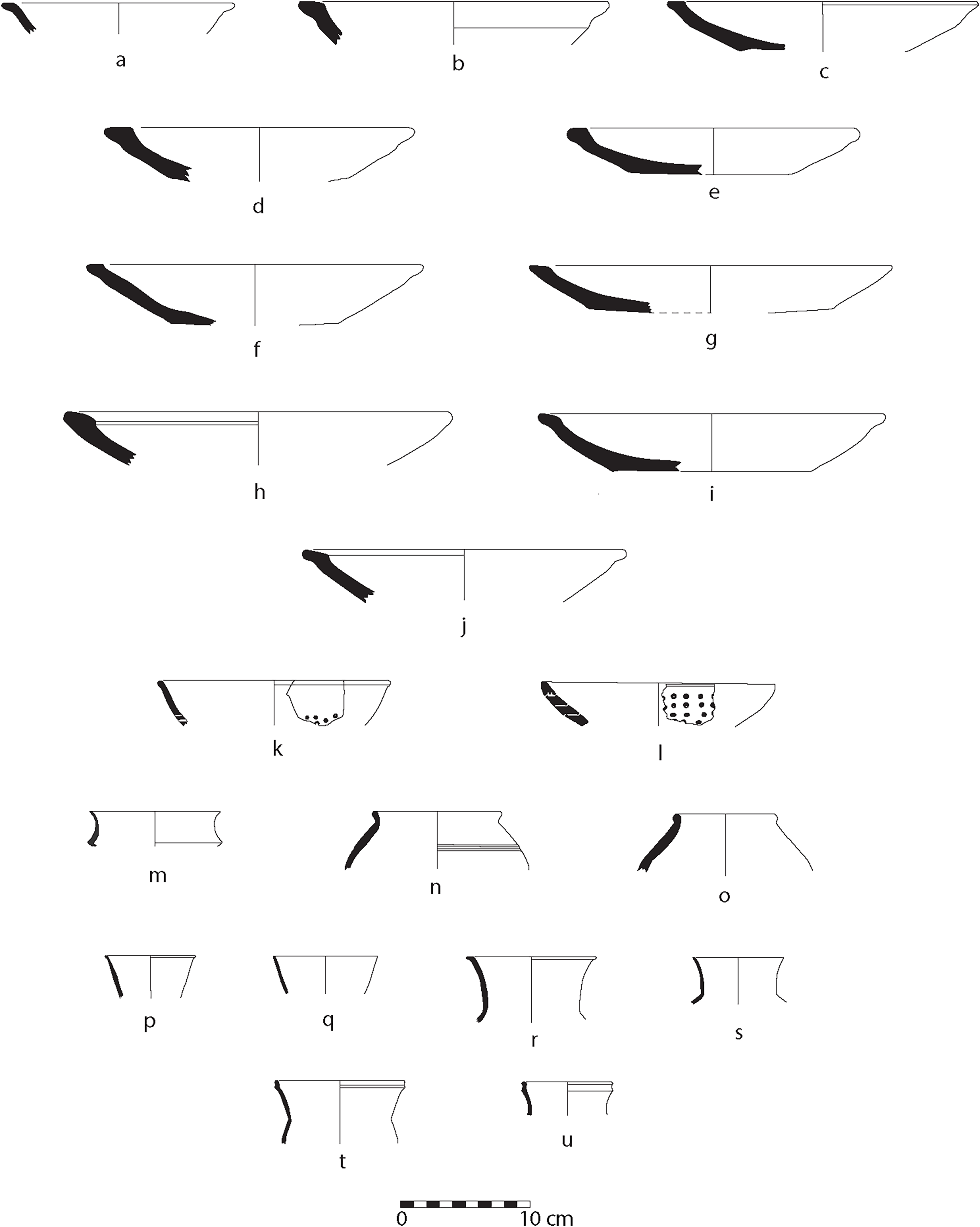
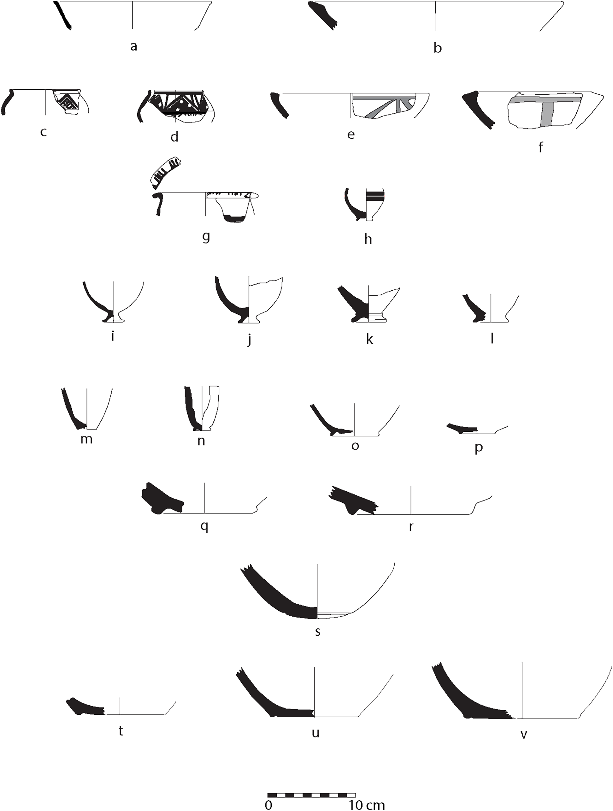
Open bowls: These account for a significant proportion of total vessel types, as with MB pottery elsewhere at the site (e.g., Schwartz et al. Reference Schwartz, Brinker, Creekmore, Feldman, Smith and Weber2017: fig. 25: 1–14). Small non-carinated bowls tend to be light yellow-green to pink brown and largely without vegetal temper but with fine black and white mineral particles. Fine-walled bowls with simple, rounded or tapered rims and low ring bases are well attested (Fig. 23: a–c) (cf. Schwartz Reference Schwartz, Coppini and Oseliniin press: fig. 2: 1; fig. 4: 3; fig. 7: 1–2). Fine concentric striations indicate that the wheel was used, at the very least, to finish the vessels.
MB ceramics, trench 5065/2985
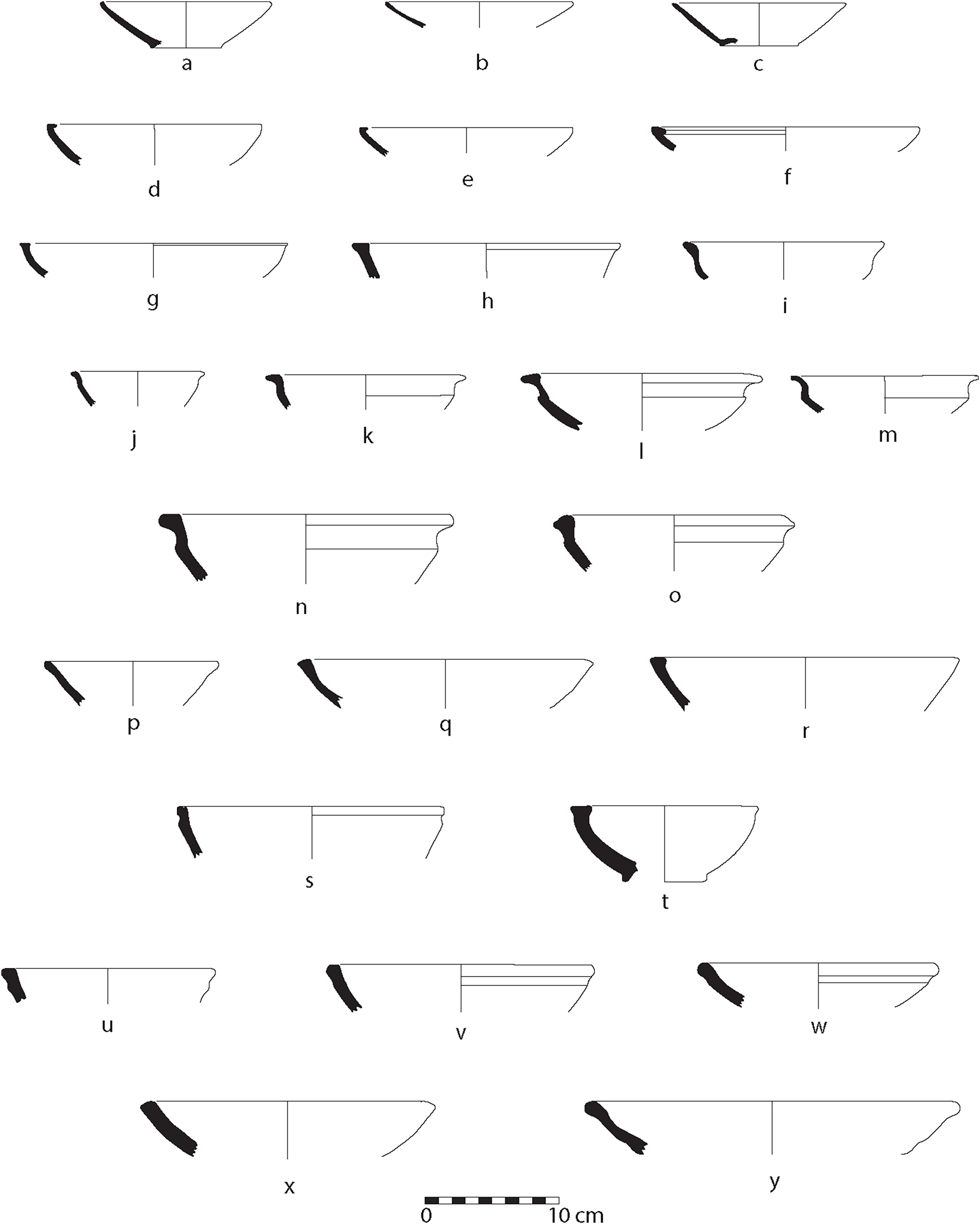
Another typical small bowl has a flat, inverted rim and low ring base (Fig. 23: d–e) (cf. Schwartz Reference Schwartz, Coppini and Oseliniin press: fig. 4: 2; fig. 7: 11). Inverted rims also occur on somewhat larger bowls with similar fabrics and colours (Fig. 23: f). A bowl with a flat rim has an outward ledge and slight protrusion on the interior side (Fig. 23: g–h) (cf. Schwartz Reference Schwartz, Coppini and Oseliniin press: fig. 4: 1; fig. 10: 1–2).
Carinated bowls: Some small bowls have carinations below turned-out rims and are either gently (Fig. 23: i–k) or strongly carinated (Fig. 23: l–m). No vegetal inclusions or mineral particles were evident; colours were light pink, pink-brown or light yellow (cf. Schwartz Reference Schwartz, Coppini and Oseliniin press: fig. 2: 6; fig. 4: 5–7, 11). Similar bowls are attested at Gir-e Gomel on the Navkur plain to the northwest (Morandi Bonacossi et al. Reference Morandi Bonacossi, Ahmad Qasim, Coppini, Gavagnin, Girotto, Iamoni and Tonghini2018: fig. 47: 7).
Larger carinated bowls with outwardly everted rims (Fig. 23: n–o) are pale yellow or pale brown with some vegetal material and sand-sized white and black mineral particles (cf. Schwartz et al. Reference Schwartz, Brinker, Creekmore, Feldman, Smith and Weber2017: fig. 25: 10).
Miscellaneous Bowls: Many bowls have only one or two examples (Fig. 23: p–y). Usually, they have fine black or white mineral particles, underlining their production from local clay. Smaller bowls have little or no vegetal inclusions, whereas larger bowls with thicker walls have moderate quantities. It therefore appears that it is the size of the bowl that dictates the addition of vegetal materials. In general, larger vessels in the assemblage had more vegetal inclusions.
Everted rimmed bowls (Fig. 24: a–j): These shallow bowls have a fairly thick, flat, everted rim and can display a range of everted postures, including an interior edge that angles downwards (cf. Schwartz et al. Reference Schwartz, Brinker, Creekmore, Feldman, Smith and Weber2017: 232 and fig. 25: 1–7; Schwartz et al. Reference Schwartz, Creekmore, Smith, Weber and Webster2022: 207 and fig. 22: 1–4; Schwartz Reference Schwartz, Coppini and Oseliniin press: fig. 2: 7–17; fig. 4: 17–21; fig. 7: 9, 14; fig. 10: 9–19). Small and moderately large shallow bowls may have rims that are flat at the top and protrude outward like a ledge (Fig. 24: a–f). Also attested are fairly large shallow bowls with flat rims that angle downward towards the interior (Fig. 24: g–j).
MB ceramics, trench 5065/2985
Everted rimmed bowls are usually light yellow, pink or light brown, with the same colours on both surfaces and in the core, attesting to well-regulated, consistent firing conditions. Most have sand-sized white and black mineral particles and some vegetal temper. In appearance they appear rather coarse, and one wonders if they were predominantly used in household domestic contexts.Footnote 22
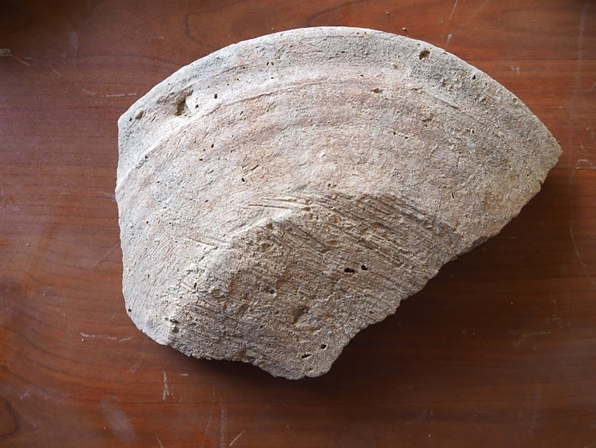
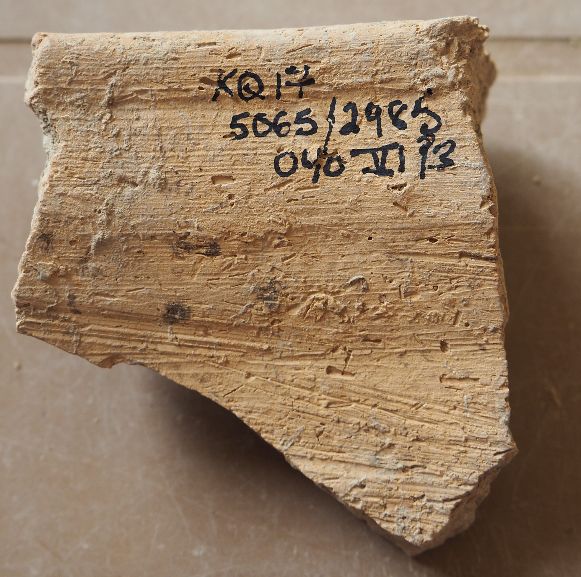
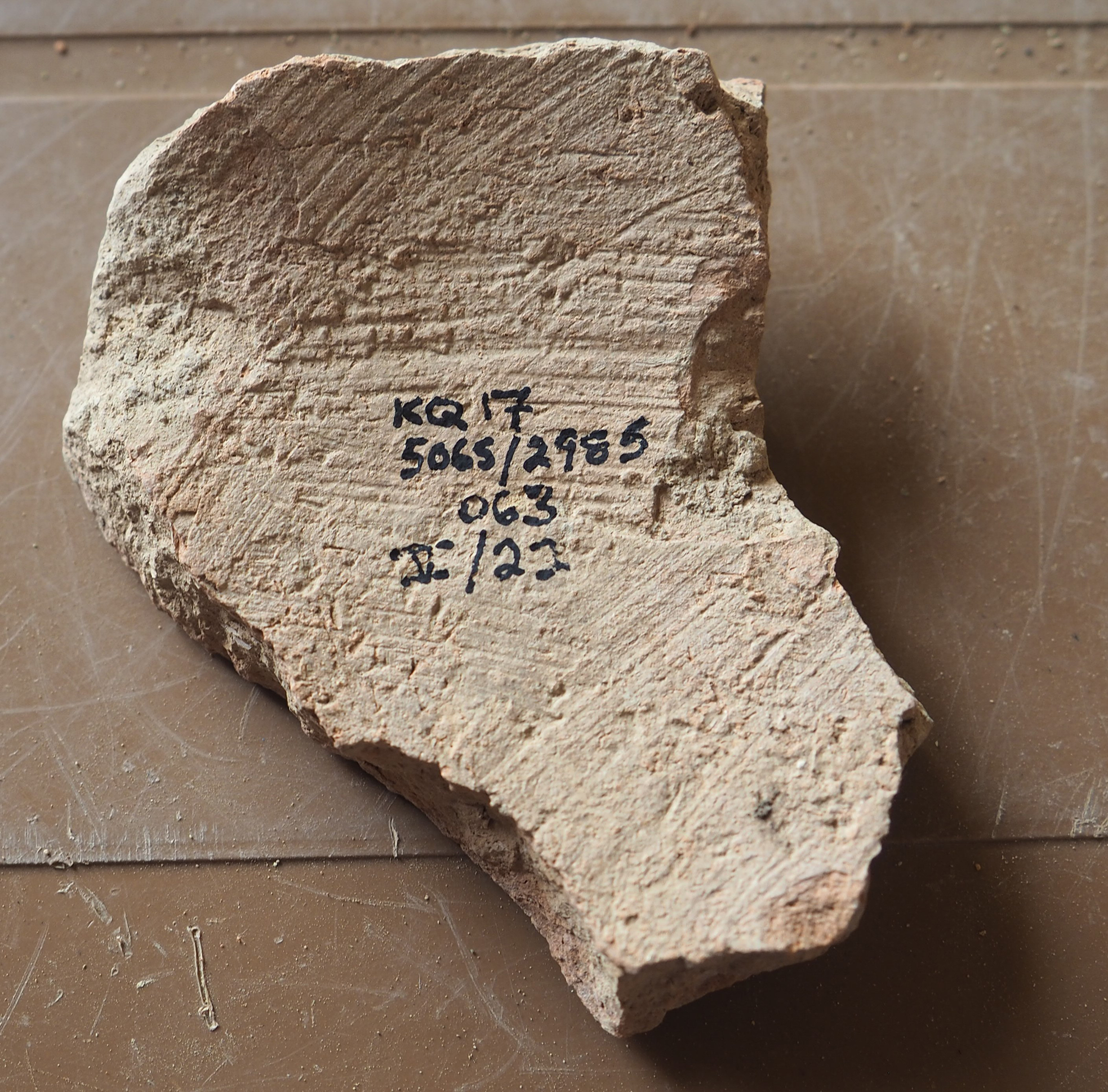
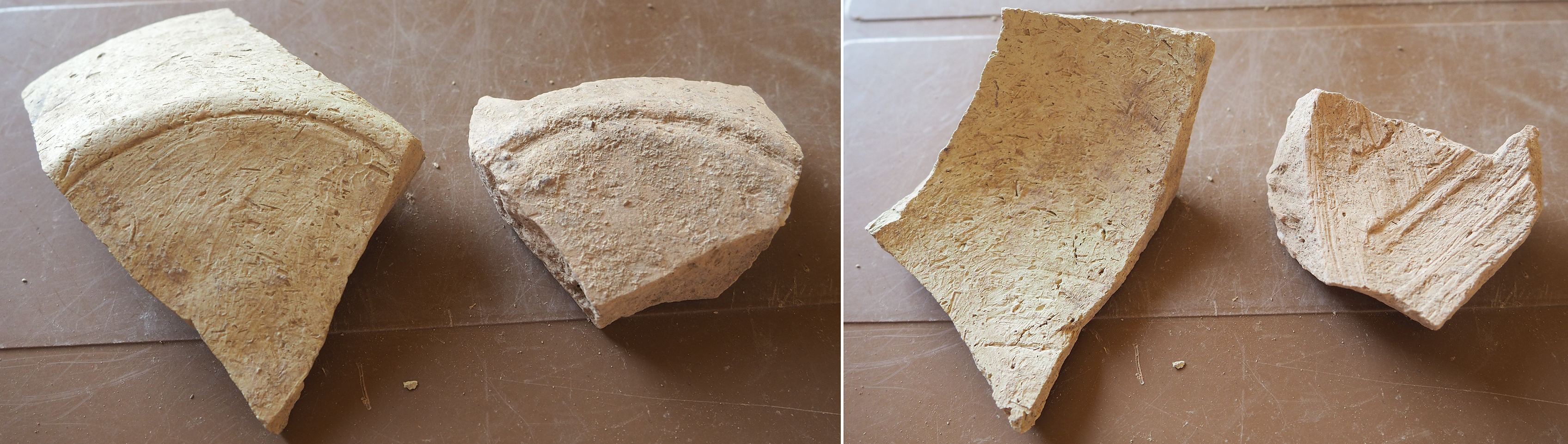
Some of the bases of this bowl type have a channel or ring base and are comparable to others noted elsewhere at the site (cf. Schwartz et al. Reference Schwartz, Brinker, Creekmore, Feldman, Smith and Weber2017: fig. 25: 4; Schwartz Reference Schwartz, Coppini and Oseliniin press: fig. 4: 26; fig. 10: 9). However, the majority of bases from this study are flat and roughly finished on the outside. Similar bowls from Rimah (“Rough-based Shallow Bowls”, Postgate et al. Reference Postgate, Oates and Oates1997: 65, pl. 47–49) have comparable bases. Postgate et al. suggest that these rough bases may have been made by pressing clay into a mould or form composed of rough material such as wood, with no attempt to smooth its rough exterior surface (1997: 65). However, the 5065/2985 bases appear instead to have been scraped or shaved with a tool dragged across the surface, removing excess clay to create a fairly flat base. The scraping marks either extend from one side of the base to the other (Fig. 25), or more frequently, they appear in a circular fashion, suggesting that the base was rotated, perhaps on a wheel, while it was being scraped (Fig. 26). One can envision that the bowl was turned upside down for this stage of the finishing process, perhaps when it had reached a leather-hard stage of dryness.
Scraping marks from one side to the other, and over the edges, on base of an everted rimmed bowl
Circular scraping marks on base of an everted rimmed bowl
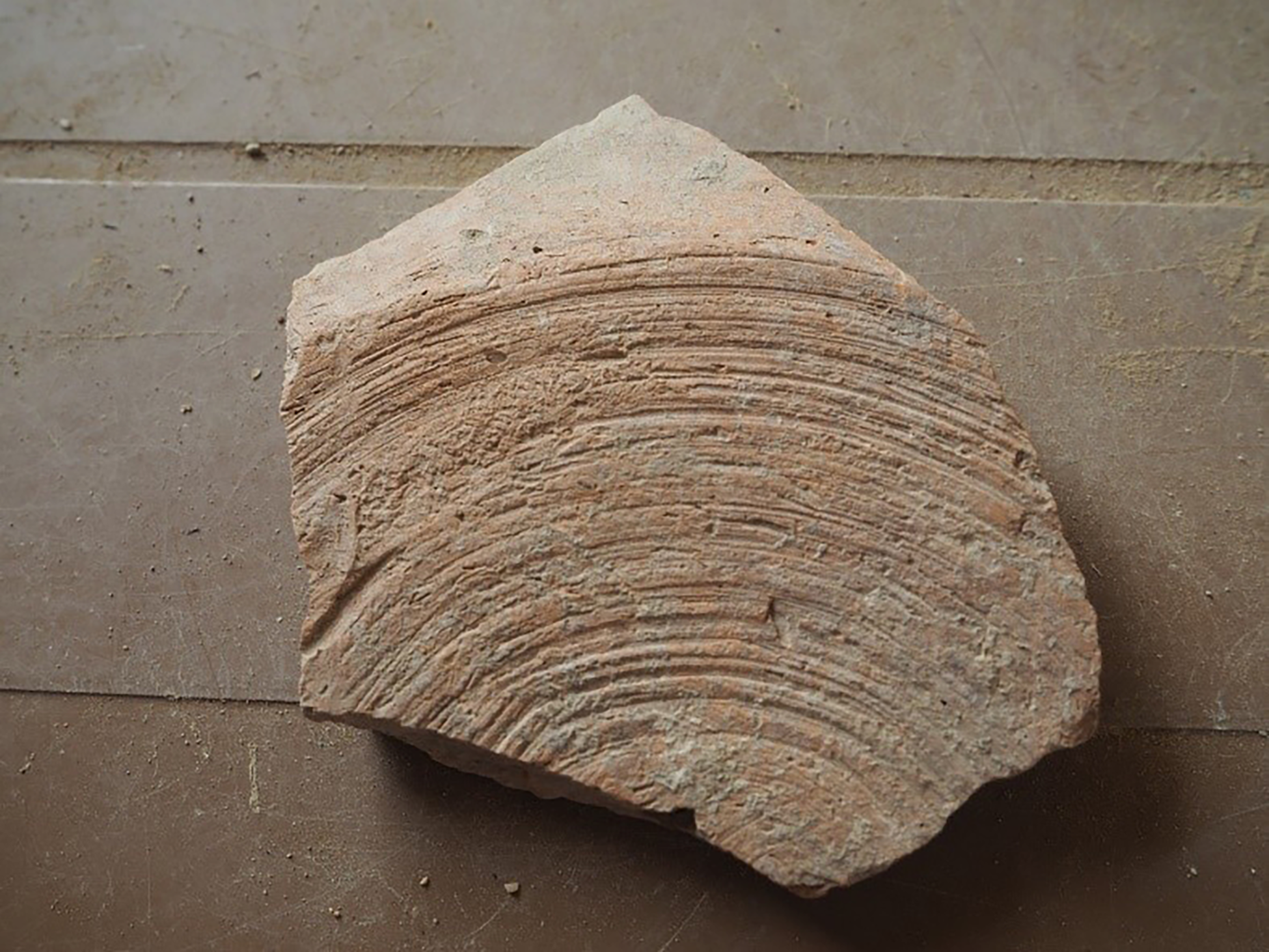
These bowls also display widely-spaced concentric lines or grooves on both the exterior and interior vessel walls (see Fig. 25). Such features are consistent with forming by hand using coils but finished and smoothed on a rotating wheel. Fine, closely spaced concentric lines indicative of throwing and forming on a fast wheel are missing, and the coarse fabrics would have made fast-wheel production challenging.Footnote 23
Colanders: These have an open bowl-like form with a simple or slightly thickened rim (Fig. 24: k-l) (cf. Schwartz Reference Schwartz, Coppini and Oseliniin press: fig. 12: 19).
Deep Open Forms with Ledge Rims (Fig. 27: n–t): Many sherds have thick, out-turned ledge rims, below which are often parallel grooves or bands of comb incisions, raised ridges, incised wavy lines, bands of rope appliqué, or a combination of these decorations. Most of these rims are fragmentary, but some appear to be the rims of large deep bowls (termed ‘kraters’ by Schwartz). On the other hand, some may constitute deeper, more barrel-shaped vessels. At Chagar Bazar, the excavators distinguished separate categories of open, ledge-rimmed vessels including large deep bowls, medium barrels, large barrels, and medium and large wide-mouth jars (McMahon et al. Reference McMahon, Colantoni, Frane and Soltysiak2009: pls. 14–17, 32–36, 55–61).
MB ceramics, trench 5065/2985
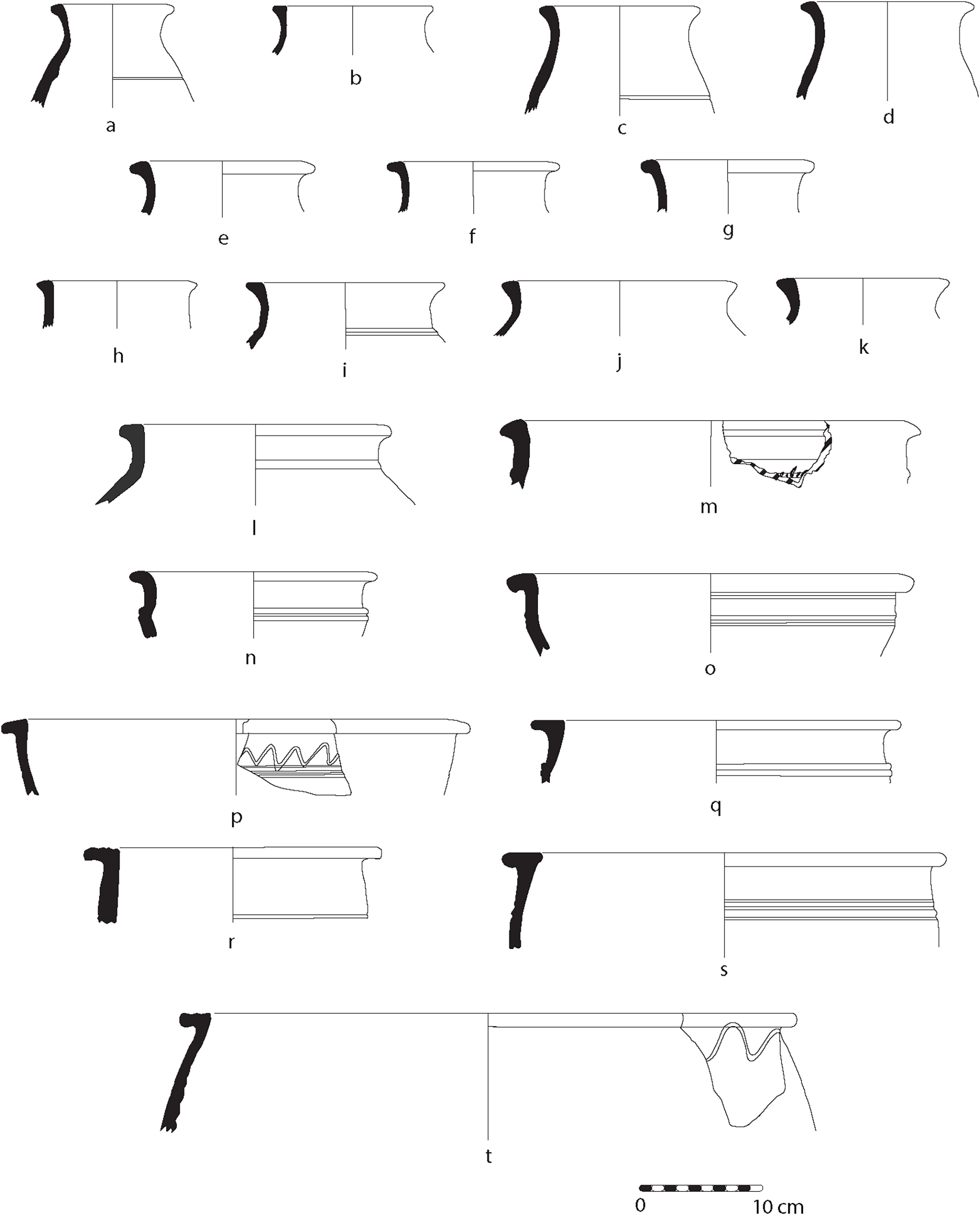
Fig. 27 Long description
Panel a: A diagram showing a large square space in the northwest quadrant of Building B, with rooms built into part of this space. Panel b: A diagram showing additional rooms extending to the south and east. Panel c: A diagram showing the overall dimensions of Building B, approximately 70 meters east-west and 100 meters north-south. Panel d: A diagram showing the thickness of the walls, mostly ranging from 12 meters. Panel e: A diagram showing especially thick walls in the southwest portion of the structure. Panel f: A diagram showing possible benches, engaged columns, or projections. Panel g: A diagram showing interior spaces with higher magnetism. Panel h: A diagram showing the layout of rooms with dimensions from 38 meters by 310 meters. Panel i: A diagram showing the erosion of the eastern edges of the structure. Panel j: A diagram showing the possible function of the courtyard. Panel k: A diagram showing the subdivisions within the courtyard. Panel l: A diagram showing the throne room 65 at Mari. Panel m: A diagram showing the main court of the Middle Bronze Temple of Aur at Assur. Panel n: A diagram showing the acropolis temple at Leilan. Panel o: A diagram showing the Middle Bronze temple at Tell al Rimah. Panel p: A diagram showing roof collapse, ash deposits, or baked brick features. Panel q: A diagram showing the magnetometer data reflecting benches, engaged columns, projections, or other decorative elements. Panel r: A diagram showing the layout of rooms and courtyards. Panel s: A diagram showing the overall structure of Building B. Panel t: A diagram showing the possible later subdivisions within the courtyard.
The open, wide nature of these vessels would have made their contents accessible. Smaller vessels may have been used as serving containers for communally shared food,Footnote 24 while larger ones would have been more stationary, possibly used for storage, out of which liquids or solid foodstuffs could be scooped. In most cases, the vessels have moderate to heavy amounts of vegetal material and are light yellow, reddish-yellow or light brown. They were built up with coils, although fine concentric lines on many of the upper portions suggest that some of the final finishing and smoothing may have been accomplished with a wheel. Rougher, multi-directional scraping has been observed farther down in the interior of many of the vessels (Fig. 28).
Fine concentric lines on upper part of the interior of an open vessel with rougher multi-direction scraping marks farther down
Deep bowls with diameters 20–38 cm (Fig. 27: n–p) may have comb-incised bands, grooves between raised ridges, and wavy lines below the rim. Other ledge-rimmed vessels are too fragmentary to determine their overall shape but exhibit a similar range of ledge-rim shapes and decoration below the rim (Fig. 27: q–s). There are also ledge-rimmed vessels whose diameters exceed 30 cm (Fig. 27: t). In at least two cases, the tops of the rims are ribbed.
Body sherds were sometimes found with thick walls and rope appliqué bands. These probably belong in this category of deep open forms with ledge rims. Oval-shaped rope impressions near the raised rope appliqués (Fig. 29) are, as others have proposed, probably indicative of the manufacturing process, in which the vessels would have been tied around with string and/or knots in order to support them during construction and drying before being fired (Postgate et al. Reference Postgate, Oates and Oates1997: 68; Schwartz 2022: fig. 20: 1).
Thick, raised rope appliqués, as well as smaller rope impressions in between, probably testifying to the production process of this larger vessel

Deep open ledge-rimmed vessels have been abundantly documented both on the High Mound and Lower Town at Kurd Qaburstan, attesting to their frequent use throughout the MB (Schwartz et al. Reference Schwartz, Brinker, Creekmore, Feldman, Smith and Weber2017: fig. 25: 15–17; Schwartz et al. Reference Schwartz, Creekmore, Smith, Weber and Webster2022: fig. 21: 1–5; Schwartz Reference Schwartz, Coppini and Oseliniin press: fig. 2: 20; fig. 5: 1–7; fig. 11: 5–14; cf. also Morandi Bonacossi et al. Reference Morandi Bonacossi, Ahmad Qasim, Coppini, Gavagnin, Girotto, Iamoni and Tonghini2018: fig. 47: 1–3; Postgate et al. Reference Postgate, Oates and Oates1997: 68; pl. 65).
Cups: A small number of rims of small cups are characterized by fine ware and wheel-made production (Fig. 24: m–o). Some shouldered cups have a slightly thickened rim that is gently turned out (Fig. 24: n–o). Tiny black mineral particles could be observed but no vegetal material. Colour is pale red, light yellow or a pale green. Fine, concentric lines on the vessel walls attest to production on a fast wheel. Interestingly, the form, fabric and technology of these cups match those of painted cups of the Khabur Ware tradition represented at Kurd Qaburstan (see below).
Given this observation, one might have thought that the cups had been decorated with paint that had eroded. Evidence from Rimah, however, suggests that a class of undecorated cups existed alongside comparable painted Khabur Ware cups (Postgate et al. Reference Postgate, Oates and Oates1997: pl. 79: 879–881; see also similar vessels from Tell Brak and Tell Leilan: Frane Reference Frane1996: fig. 67: 2, 68: 1; Oates et al. Reference Oates, Oates and McDonald1997: 291–292). At Rimah, they are particularly frequent in the Old Babylonian levels dating to the time of Zimrilim of Mari before giving way almost entirely to painted cups and longer-necked beakers of the later Old Babylonian period (Postgate et al. Reference Postgate, Oates and Oates1997: 52). If this chronological pattern applies to Kurd Qaburstan, the presence of undecorated ‘Khabur Ware’-related cups might also date the MB levels to the time of Zimrilim, c. 18th century B.C.
Fine Ware Goblets: These have thin rims that slope gently outwards and taper to a point (Fig. 24: p–q) (cf. Schwartz Reference Schwartz, Coppini and Oseliniin press, fig. 10: 31–32). Vessels are light yellow or light pink, without visible vegetal or mineral inclusions. Fine concentric lines on both the interior and exterior sides of the rims attest to fast wheel manufacture.
Another fine goblet with similar characteristics has rims that slope or flare outwards and are slightly thickened at the edge, forming an outwards ‘lip’ (Fig. 24: r–s). Also with similar characteristics are fine rims thickened at the rim with a groove below the top of the rim, producing a flanged appearance in profile (Fig. 24: t–u). These vessels would have had fine bases, most probably pedestal-footed bases (Fig. 35: i–j).
Given their fragmentary state, the complete shape of these vessels is uncertain, but they appear to have relatively longer necks than the ‘shoulder goblet’ found elsewhere at Kurd Qaburstan (Schwartz et al. Reference Schwartz, Creekmore, Smith, Weber and Webster2022: 196, n. 11 and fig. 10: 3). We suggest that many of the goblets described here are mostly similar to Straight-Sided Beakers from Rimah (Postgate et al. Reference Postgate, Oates and Oates1997: pl. 67: 671–672) or, if they are shouldered, Undecorated Shouldered Beakers (Postgate et al. Reference Postgate, Oates and Oates1997: pl. 73: 757, 760, 774–775). While deriving from Old Babylonian levels, they are also found in LB contexts at Rimah (Postgate et al. Reference Postgate, Oates and Oates1997: pl. 72). Such a trend is also apparent at Kurd Qaburstan, with ‘thin-walled goblets’ in LB contexts (Schwartz Reference Schwartz, Coppini and Oseliniin press: fig. 16: 19–23) appearing alongside the painted examples of Younger Khabur Ware (Schwartz Reference Schwartz, Coppini and Oseliniin press: fig. 18: 10–13).
Small and medium-sized necked jars with everted rims: Rims are squared or triangular in profile (Fig. 27: a–k) (cf. Schwartz et al. Reference Schwartz, Brinker, Creekmore, Feldman, Smith and Weber2017: fig. 26: 1; Schwartz Reference Schwartz, Coppini and Oseliniin press: fig. 2: 23, 27–28; fig. 5: 8, 13–14; fig. 8: 9–13; fig. 12: 1–6, 8). Vegetal material is moderate, and sand-sized black mineral inclusions are attested, with colour being light yellow or very light brown. Fine concentric lines in the vessel walls attest to the use of a wheel for shaping and finishing. As before, the incomplete nature of the sherds makes it difficult to ascertain the complete forms, but there are possibly comparable shapes at Gomel (Morandi Bonacossi et al. Reference Morandi Bonacossi, Ahmad Qasim, Coppini, Gavagnin, Girotto, Iamoni and Tonghini2018: 94; fig. 23: 1–6 [Gray Ware]; 7–8 [Common Ware]). Comparisons may also be found at Rimah, many with bands of horizontal grooving at the shoulders (Postgate et al. Reference Postgate, Oates and Oates1997: 72 and pl. 88, especially no. 1018). At Tell Rijim, Type D20 appears comparable (Koliński Reference Koliński2000: 39–40, pl. 26 b).
Larger jars (Fig. 27: l–m) have thick everted rims and short necks with parallel grooves and raised ridges (cf. Schwartz et al. Reference Schwartz, Creekmore, Smith, Weber and Webster2022: fig. 20: 1–7). Vegetal inclusions and black and white mineral particles are apparent. As with the smaller jars, traces of the wheel are to be seen in the form of fine concentric rings, especially under the rim. Raised bands below the rim are common, sometimes with rope appliqué bands on the widest bands, as with the deep open forms with ledge rims.
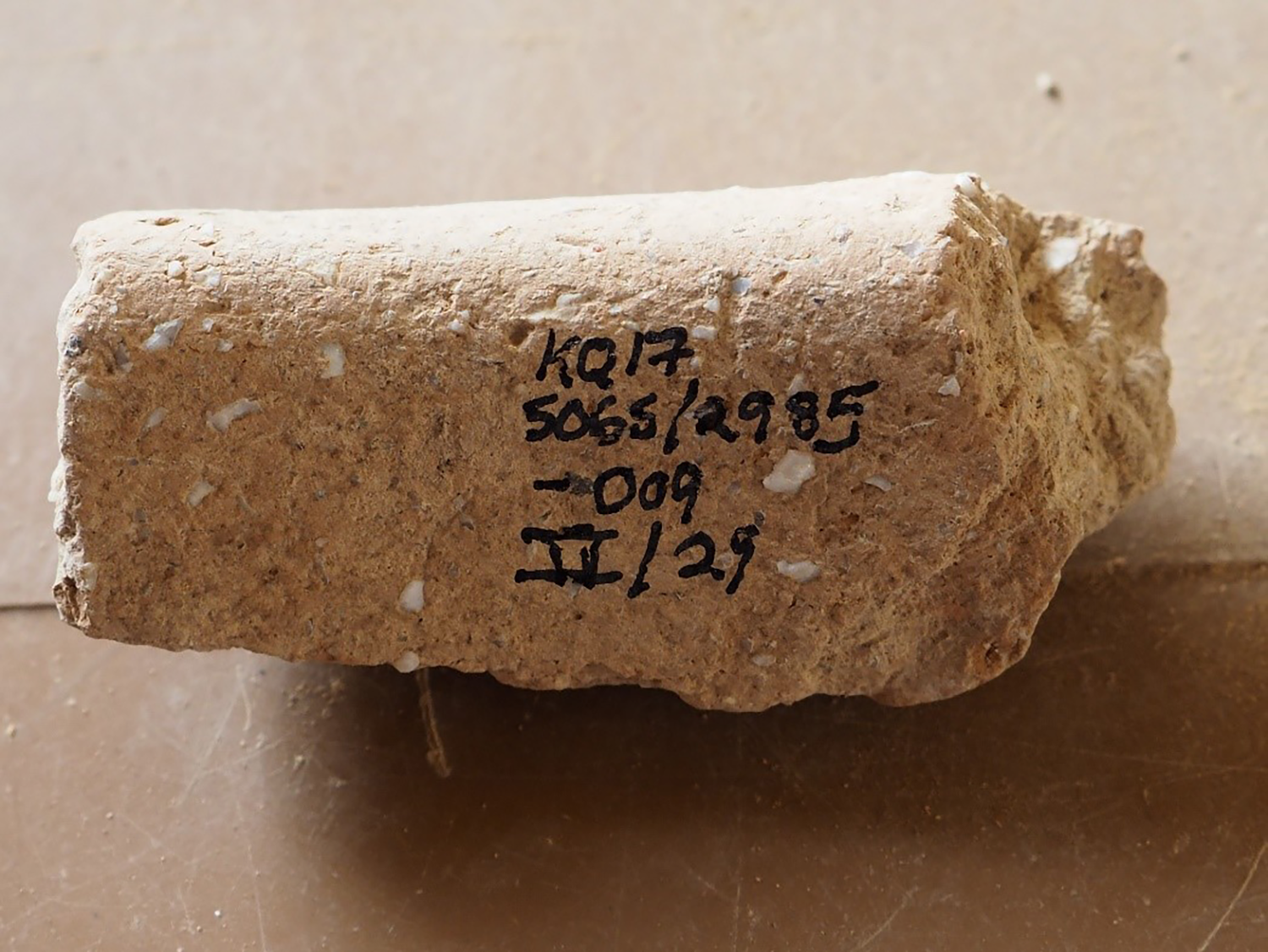
Cooking Pots: Many sherds of Cooking Pot Ware allude to the domestic activities in this part of the site. Regardless of size or shape, cooking pots share similar technological attributes. All are tempered with moderate to heavy amounts of grit-sized, angular-shaped, milky white or grey-coloured mineral temper, possibly shell. The temper is easily visible to the naked eye and is distributed across the clay fabric, making these pieces quite coarse (Fig. 30). The pots are also usually tempered with moderate amounts of vegetal temper and sand-sized black and white mineral particles. Such a similarity in fabric to other wares suggests that the cooking vessels used the same clay material as other vessels and were made locally.
Large, angular pieces of shell temper visible in the rim section of a cooking pot
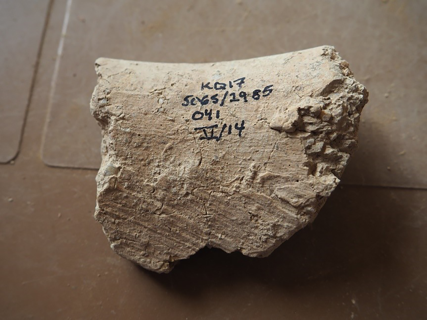
The lack of fine, evenly spaced concentric circles on the body of the cooking pots indicates they were formed without the use of a fast wheel. Nevertheless, finer circular ridges or grooves at the neck and rims of the cooking vessels suggest that some final shaping, finishing and smoothing was carried out on a wheel, namely on the upper sections of the vessels. As for the rest of the vessel, rough scraping in multiple directions was found further down in the interior, indicating the use of a scraping tool (Fig. 31). This is a distinctive feature which is attested on other vessels, especially those of the medium to large-sized open forms with ledge rims, again suggesting that that the cooking vessels were the product of local production.
Rough, multi-directional scraping on the interior of a cooking pot below the neck; dense concentration of angular particles of shell temper on the right
A common cooking pot takes the form of a small to medium-sized globular vessel with a slightly out-turned thickened rim, usually a beaded rim that is rounded or triangular in cross-section, below which is only a very short neck (Fig. 32: a–b). This was a frequently-used cooking vessel type at Kurd Qaburstan (cf. Schwartz et al. Reference Schwartz, Brinker, Creekmore, Feldman, Smith and Weber2017: fig. 26: 14–15). Farther afield, this type appears at Tell Leilan (period of Shamshi-Adad’s rule) and Chagar Bazar (post-Shamshi-Adad’s rule, after 1776 B.C.), although horizontal burnishing appears far more frequently at these sites than at Kurd Qaburstan (Frane Reference Frane1996: fig. 58; McMahon et al. Reference McMahon, Colantoni, Frane and Soltysiak2009: pl. 63).
MB ceramics, trench 5065/2985
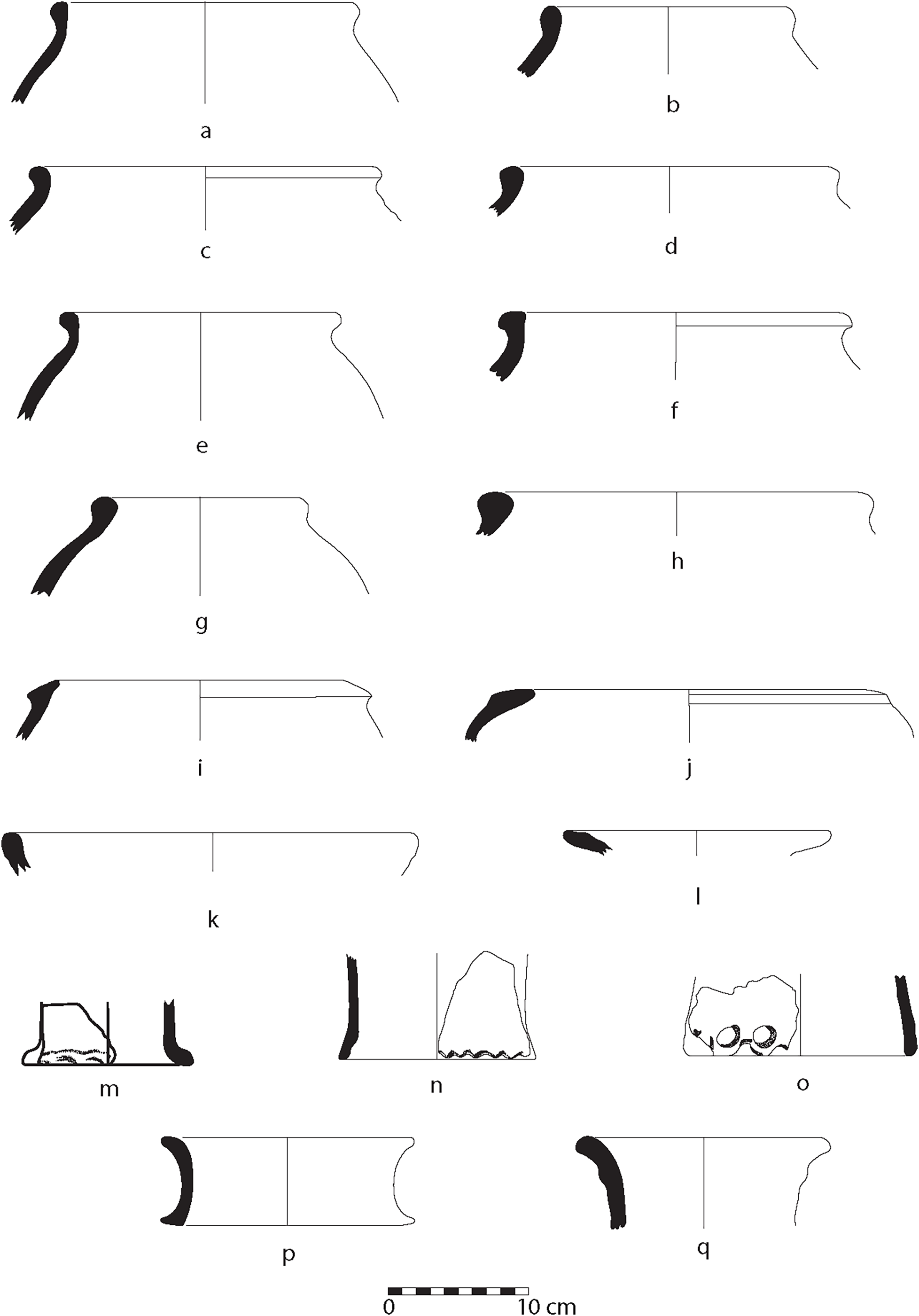
Fig. 32 Long description
Panel a: Illustration of a ceramic pot rim with a slightly out-turned thickened rim and a short neck. Panel b: Illustration of a ceramic pot rim with a rounded beaded rim. Panel c: Illustration of a ceramic pot rim with a slightly out-turned thickened rim and a short neck. Panel d: Illustration of a ceramic pot rim with a rounded beaded rim. Panel e: Illustration of a ceramic pot rim with a slightly out-turned thickened rim and a short neck. Panel f: Illustration of a ceramic pot rim with a rounded beaded rim. Panel g: Illustration of a ceramic pot rim with a slightly out-turned thickened rim and a short neck. Panel h: Illustration of a ceramic pot rim with a rounded beaded rim. Panel i: Illustration of a ceramic pot rim with a slightly out-turned thickened rim and a short neck. Panel j: Illustration of a ceramic pot rim with a rounded beaded rim. Panel k: Illustration of a ceramic pot rim with a slightly out-turned thickened rim and a short neck. Panel l: Illustration of a ceramic pot rim with a rounded beaded rim. Panel m: Illustration of a ceramic pot base with a flat bottom. Panel n: Illustration of a ceramic pot base with a rounded bottom. Panel o: Illustration of a ceramic pot base with a flat bottom and a decorative element. Panel p: Illustration of a ceramic pot base with a rounded bottom. Panel q: Illustration of a ceramic pot rim with a slightly out-turned thickened rim and a short neck.
Other cooking pot rims are thickened, with a variety of everted profiles (Fig. 32: c–g) (cf. Schwartz Reference Schwartz, Coppini and Oseliniin press: fig. 8: 26). With a few vessels, the rims are thick and wide, with a hammerhead appearance (Fig. 32: h) (cf. Schwartz Reference Schwartz, Coppini and Oseliniin press: fig. 12: 28). The shape of the base of these cooking pots is not certain, although a recovered low ring base with shell temper may be associated with this type, as well as a flat base with a slightly pronounced base edge. With both bases, there are no traces of wheel marks, and they appear to have been roughly scraped in different directions on the interior (Fig. 33), these features attesting to the hand-made character of the vessels, at least in their lower sections. In one case, the cooking pot’s exterior shoulder appears to have been lightly burnished (Fig. 32: g). Otherwise, burnishing was not often observed on these vessels.
Multi-directional scraping markings on interior of the flat base of a cooking pot
A somewhat different cooking pot is represented by examples with hole-mouth rims and a long, rounded thickening on the exterior, producing a lip 1–2 cm below the rim edge (Fig. 32: i–j). This type of cooking vessel is also well-attested in the post-Shamshi-Adad levels at Chagar Bazar (McMahon et al. Reference McMahon, Colantoni, Frane and Soltysiak2009: pl. 62). There are also some shell and vegetal tempered bowl forms, both of which are rather poorly shaped and smoothed by hand, which we have also placed in the cooking ware category (Fig. 32: k–l).
None of the cooking vessels show affinities with cooking pot types that become prominent in the Late Bronze Age levels known from other areas of Kurd Qaburstan. Late Bronze pots with short, everted rims, for example, are not present (for these, cf. Schwartz Reference Schwartz, Coppini and Oseliniin press: fig. 18: 3–5; fig. 20:1, 3-4), seemingly underlining the solid Middle Bronze Age date of these vessels.
Piecrust Stands: A very distinctive ceramic type from KQ 5065/2985 is what is often referred to as a ‘piecrust’ potstand, since it has a finger-indented frill around its base (Fig. 32: m–o).Footnote 25 As a secondary use, many of these stands were fitted together, top to bottom, and used as elements in drains. This use was noted in the earlier MB phase 4, where in Area 6 a drain had been sunk into the ground that used these stacked piecrust stands (Schwartz et al. Reference Schwartz, Creekmore, Smith, Weber and Webster2022: 204–205). Such a feature was also noted in the Lower Town North A, where the stands created a horizontal drain (Later MB; Schwartz et al. Reference Schwartz, Brinker, Creekmore, Feldman, Smith and Weber2017: 232).
All nine stand fragments have moderate quantities of vegetal temper, along with sand-sized white or black mineral particles. The stands were produced with clay coils but then finished on a rotative device, attested by well-spaced concentric circles appearing on the walls of several of the stands. The piecrust edge, appearing at the base of the stand, appears to have been made of a long rope of clay that was attached to the stand by pressing it with the fingers and messily attaching it by smearing the clay over the interior and exterior sides, leaving many fingerprints and unsmoothed, raised globs of clay at the join (Fig. 34). The potter’s fingers were then pressed into the exterior side of the edge, forming half-moon-like indents and a slightly out-turned base edge. All of the examples of these piecrust edges are quite rough looking, with no effort to achieve any aesthetic appearance, thereby attesting to the stands’ practical purposes. While none of our piecrust stands are complete, we may reconstruct the top edge to be characterized by a simple rounded rim that flares outwards (Schwartz Reference Schwartz, Coppini and Oseliniin press: fig. 3: 9).
Interior of piecrust stand fragment, showing slight bulge where rope of clay for piecrust edge was messily added onto main section of stand

The number of attestations of piecrust stands from MB levels at Kurd Qaburstan (cf. Schwartz et al. Reference Schwartz, Brinker, Creekmore, Feldman, Smith and Weber2017: fig. 26: 17; Schwartz Reference Schwartz, Coppini and Oseliniin press: fig. 3: 6–9; fig. 6: 3–4; fig. 12: 17–18) confirm that they were well in use during this period, and not, as was previously argued, restricted only to the Late Bronze Age (Schwartz et al. Reference Schwartz, Brinker, Creekmore, Feldman, Smith and Weber2017: 232; now also MB Gomel, cf. Morandi Bonacossi et al. Reference Morandi Bonacossi, Ahmad Qasim, Coppini, Gavagnin, Girotto, Iamoni and Tonghini2018: 126, n. 213 and fig. 47: 4).
Other Potstands: Of other potstands, in only one case is both the base and rim fully preserved (Fig. 32: p). In three examples, a slight swelling on the exterior below a similarly thickened rounded edge matches a complete potstand from elsewhere at Kurd Qaburstan (Fig. 32: q) (Schwartz Reference Schwartz, Coppini and Oseliniin press: fig. 12: 16). Another example is characterized by a strongly out-turned edge (cf. Schwartz Reference Schwartz, Coppini and Oseliniin press: fig. 12: 15). All examples have moderate amounts of vegetal temper, light brown or yellow colour, and indications of coil production, suggesting that they were produced in way comparable to piecrust stands. Potstands without piecrust edges are attested in MB contexts elsewhere at Kurd Qaburstan (Schwartz et al. Reference Schwartz, Creekmore, Smith, Weber and Webster2022: fig. 22: 6) and Rimah (Postgate et al. Reference Postgate, Oates and Oates1997: pl. 95).
Gray Ware (Fig. 35: a–b): Relatively rare in MB Kurd Qaburstan, Gray Ware typically has fine sand inclusions and burnishing. Vessels frequently take the form of bowls (Schwartz Reference Schwartz, Coppini and Oseliniin press: fig. 3: 14–15, fig. 6: 9; fig. 8: 22; fig. 12: 27), a variety of closed forms (Schwartz Reference Schwartz, Coppini and Oseliniin press: fig. 3: 16; fig. 6: 10–12; fig. 8: 23), and occasionally incised decoration that sometimes has a white paste inlay (Schwartz Reference Schwartz, Coppini and Oseliniin press: fig. 3: 16; fig. 6: 11). Grey Ware has been documented in sites of the LoNAP survey (Gavagnin et al. Reference Gavagnin, Iamoni and Palermo2016: fig. 14: 10–11; Coppini Reference Coppini and Salisbury2018: fig. 4), MB excavations at Gomel in the same region (Coppini Reference Coppini and Salisbury2018: fig. 13; Morandi Bonacossi et al. Reference Morandi Bonacossi, Ahmad Qasim, Coppini, Gavagnin, Girotto, Iamoni and Tonghini2018: fig. 19: 4–6, 8–9; fig. 23: 1–6; fig. 26: 4), and elsewhere (Morandi Bonacossi et al. Reference Morandi Bonacossi, Ahmad Qasim, Coppini, Gavagnin, Girotto, Iamoni and Tonghini2018: 88). Our specimens of Gray Ware include a fine out-flaring bowl rim (Fig. 35: a) and a relatively shallow bowl with everted rim akin to others in the everted rim bowl category described above but without chaff temper and with a distinctive pale gray colour (Fig. 35: b). A body sherd characterized by small impressed circles and fine incised lines inlaid with a white paste matches Gray Ware decoration found elsewhere both in the MB and in LB, including at Kurd Qaburstan itself (Schwartz Reference Schwartz, Kopanias and MacGinnis2016: fig. 12: sherd on left).
Khabur Ware and other painted vessels: Eleven vessel fragments were found with painted decoration, most of which can be classified as belonging to Khabur Ware. Three are Khabur Ware cups (Fig. 35: c–d). We prefer here to use the term ‘cup’ as opposed to ‘shouldered beaker’, the latter having a much longer neck and therefore constituting a separate vessel type (see especially Postgate et al. Reference Postgate, Oates and Oates1997: pls. 73–75 for both undecorated and painted versions of the long-necked shouldered beakers). The cups have a similar form, with a wall that angles inwards from the midway point to the top before an everted, thickened rim. Their painted designs feature painted hatched triangles and horizontal bands below (preserved on two of the fragments). The colour of the paint on the three specimens is dark brown, which was applied over a fired clay fabric that is reddish yellow, light yellow or light green in colour. Few to no vegetal inclusions were observed, with very small black and white mineral particles. The vessels appear to have been formed and finished on the wheel, judging by their fairly fine fabric and finely spaced concentric lines on the vessel walls. Good parallels to the cups can be found in several other MB contexts at Kurd Qaburstan (e.g. Schwartz et al. Reference Schwartz, Brinker, Creekmore, Feldman, Smith and Weber2017: fig. 27: 1, 3–4). Clearly, this is a well-known type at the site.
To the north, these vessels have been recovered in the LoNAP survey area (Gavagnin et al. Reference Gavagnin, Iamoni and Palermo2016: fig. 14: 1; Coppini Reference Coppini and Salisbury2018: fig. 3: c–e), and at Gomel (Operation 2, phase 11B, which falls in the Old Babylonian period but not as late as the late 17th to early 16th centuries B.C., which is the date of subsequent phase 10; cf. Morandi Bonacossi et al. Reference Morandi Bonacossi, Ahmad Qasim, Coppini, Gavagnin, Girotto, Iamoni and Tonghini2018: 130, and fig. 48: 4–5, although these do not have hatched triangles). At Rimah, several of the painted Khabur Ware cups from Old Babylonian levels also compare well to our painted cups (Postgate et al. Reference Postgate, Oates and Oates1997: pl. 79, especially 891–896). It is interesting to note the co-occurrence of plain, unpainted cups of the same form at Rimah, also observed at Kurd Qaburstan (see above). Even farther to the west at Tell Leilan, one sees a comparable painted hatched cup from the time of Shamshi-Adad (Frane Reference Frane1996: fig. 68: 5). At Chagar Bazar, good parallels are those predominantly occurring in Phase III and dated after the reign of Shamshi-Adad (late 18th century B.C.) (McMahon et al. Reference McMahon, Colantoni, Frane and Soltysiak2009: pl. 45: 11–14).
Two painted deep bowls feature everted, ledge rims. Dark brown painted stripes are present on the smaller vessel’s rim as well as a horizontal band of paint preserved on its shoulder (Fig. 35: g), while the larger vessel’s rim is painted a solid reddish brown on the top.
Two painted body sherds (not illustrated) may belong to large necked jars, judging by the considerable thickness of their walls. One is characterized by red painted bands, below which are hatched triangles, while the other fragment simply features horizontal bands of red paint, likely occurring on the shoulder of the vessel. At Kurd Qaburstan, these pieces probably parallel tall necked jars with horizontal stripes attested in other MB contexts (e.g. Schwartz et al. Reference Schwartz, Brinker, Creekmore, Feldman, Smith and Weber2017: fig. 27: 5–6). At Chagar Bazar, where Khabur Ware is particularly popular, painted hatched triangles are attested on several of the large, open forms, including ridged barrels and medium, wide-mouth jars (McMahon et al. Reference McMahon, Colantoni, Frane and Soltysiak2009: pl. 39: 8; pl. 59: 2, 4; pl. 60: 5–7).
Of the small painted bottle, the ring base is preserved (about 2 cm), but not the rim (Fig. 35: h). The brown painted decoration consists of two bands on the body of the vessel. Nothing comparable to this form has been recovered from other MB levels at Kurd Qaburstan. At Gomel, however, Grave 21, dated by the excavators to MB II, features a comparable small bottle with painted bands and a ring base (Morandi Bonacossi et al. Reference Morandi Bonacossi, Ahmad Qasim, Coppini, Gavagnin, Girotto, Iamoni and Tonghini2018: 98–99; fig. 26: 3).
Two painted bowl forms feature flat, thickened rims that either slope downward towards the interior of the bowl, or on the exterior (Fig. 35: e–f). Horizontal red or black painted bands are found on and below the rim, with one example also featuring a vertical painted band. These vessels appear to have been formed and finished on a fast wheel. The best parallels come not from among Khabur Ware specimens but from painted bowls found in the Iraqi Middle Euphrates at the MB site of Haradum (Khirbet ed-Diniye), as noted previously by Schwartz (Schwartz Reference Schwartz, Kopanias and MacGinnis2016: 397, and fig. 16: 8).
Bitumen staining: Schwartz observed that many large MB vessels, particularly ledge-rimmed kraters and jars, could have bitumen applied in streaks, bands and design motifs on the interior, exterior, rim or near or on the base (Schwartz et al. Reference Schwartz, Creekmore, Smith, Weber and Webster2022: 207; fig. 20: 1–5; fig. 21: 1; fig. 23; Schwartz Reference Schwartz, Coppini and Oseliniin press: fig. 8: 13; fig. 9: 7–8; fig. 11: 9). Our evidence does not contradict these observations. Several examples of bitumen application occurred on medium-sized jars with everted rims, where the bitumen was on the top of the rim and in streaks or blotches down the neck (for examples of jar rims with bitumen, see Fig. 27: j–k). In addition, bitumen was found on or below the rim of larger open forms with ledge rims (Schwartz’s ‘ledge-rimmed kraters’), as well as over the area of the vessel’s body, including its rope appliqués. The application of bitumen often appears extensively on the interior and exterior of vessels, as in the case of a shell-tempered cooking pot rim with a fully coated interior (Fig. 36). Several fragments of bases demonstrate the application of bitumen on the exterior, sometimes as spots or blotches, but also on the interior, where the bitumen thickly covers the entire inside surface. The majority of these bases are flat or have a channel-groove. Given their thickness and diameters, we suspect that most originated from the jars and open, ledge-rimmed forms described above.
MB ceramics, trench 5065/2985
Exterior of shell-tempered cooking pot (left) and its interior, coated with bitumen (right)
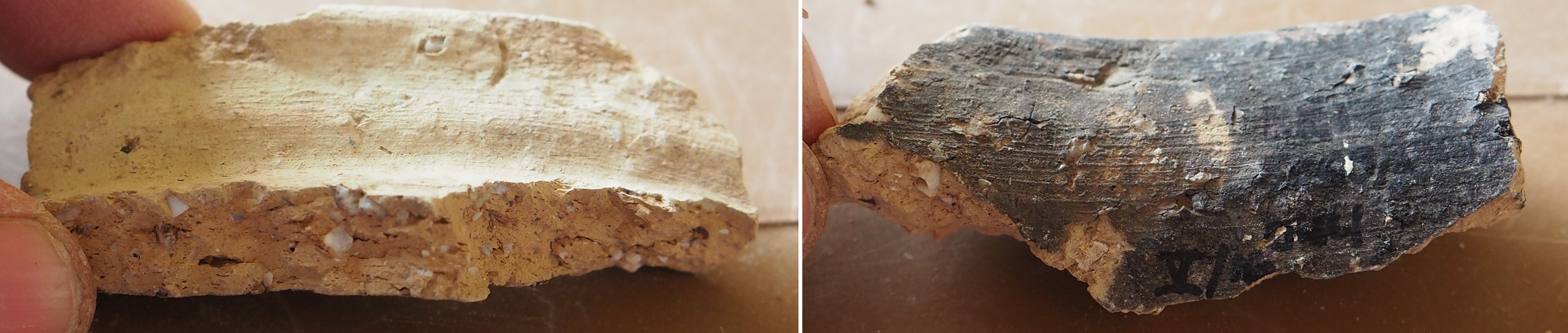
Applications of bitumen fully covering a surface, especially a base, suggest efforts to produce a non-porous, liquid-tight container. On the other hand, simple blotches of bitumen on various parts of a vessel may serve another purpose, perhaps for decoration or identifying the vessel’s contents, owner, or place of production. Neither bowls nor cups exhibit bitumen application, nor do painted vessels.
Bases: The several base types identified attest not only to a wide variety of vessels in MB but also a range of ceramic production techniques. Some fine-ware bases were high-footed, supporting a globular body (Fig. 35: i–j). Although all specimens were broken below the midway point, we suspect that these bases derive from the fine, thin-walled goblets with flaring rims described above (Fig. 24: p–u), given their complementary dimensions, wheel manufacture, temper, and colour. Although lower footed bases were also attested, they supported a larger globular body, perhaps of a cup, than those of the previous type (Fig. 35: k–l). Similarly fine goblet or cup bases with low feet were attested in seven examples. The preserved lower sections of some of these goblets indicate that they were cylindrical, approaching the appearance of tall beakers (Fig. 35: m–n), for which no complete specimens have yet been recovered from MB Kurd Qaburstan.
Wider bases with low ring bases supported larger, wider vessel forms such as bowls or small to medium-sized jars and pots (Fig. 35: o–p). In most cases, they exhibit wheel finishing and fairly fine fabrics with small or no vegetal inclusions. In contrast are thick ring-bases with coarser fabrics, having moderate amounts of vegetal inclusions or grit-sized mineral particles such as shell or quartz, and no evidence of the wheel (Fig. 35: q–r). These probably derived from large necked jars or open, ledge-rimmed vessels.
One final, distinctive and common base is the channel, which has a thick, mostly flat base and a groove accentuating the outer circumference of the base’s circular form (Fig. 35: s–v). The channel groove may have been created to provide additional stability for a simple, flat-standing vessel. Nevertheless, sometimes the channel groove was placed above a rounded base, thereby resulting, inexplicably, in a channel that would not have made contact with the surface upon which the vessel was placed (Fig. 35: s). The groove can be either deep or shallow, formed by a slightly blunt instrument when the clay of the base was still wet (Figs. 37–38). The technology for producing these bases is different from that of a ring-base, which is usually created by adding a separate rope of clay to the exterior of the base and smoothing and modelling it to resemble a protruding foot. With channel grooves, no such additional clay rope was added; the groove was made by a tool impressed into the wet clay of the base.
Exterior (left) and interior (right) of two channel bases
Exterior of base showing deeply grooved channel along outer edge
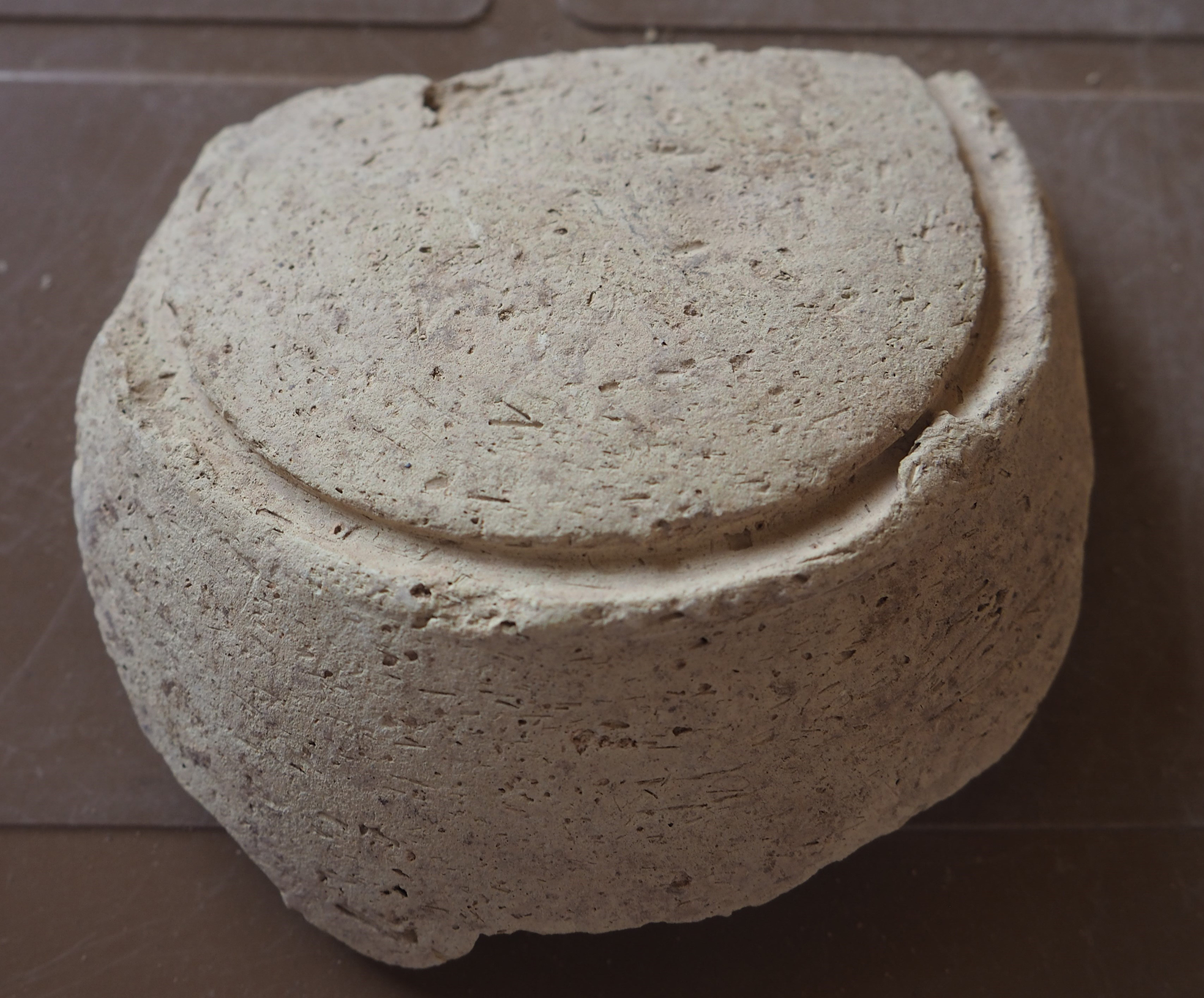
Channel bases tend to be relatively thick, suggesting they belonged to moderate to large vessels. They also appear on bowls (Schwartz Reference Schwartz, Coppini and Oseliniin press: fig. 4: 26). The interiors of the channel bases exhibit numerous deep scraping marks made in many different directions and forming a rough interior (Fig. 37, right). No doubt these interiors were never meant to be seen, which suggests that most of their vessels were tall and relatively closed forms, mainly jars. We noted above that rims of deep, open ledge-rimmed vessels had, in addition to concentric circles suggesting the use of the wheel, multi-directional scraping markings lower in the interior of the vessel. Such markings may attest to the different production methods used for the manufacture of a large vessel, the base and body probably formed with coils by hand. Alternatively, as suggested by at least one channel base, a slab of clay was pressed into a mould to create the base and lower section of the vessel (Fig. 39). Some shaping of the clay would have been done with a fairly coarse shaving or scraping tool, visible by the multi-directional marks made, especially on the interior of the base and walls of the vessel. The neck and rim of the vessel may additionally be built by hand but smoothed and finished on a wheel.
Interior of channel base, apparently pressed in base mould and then finished roughly with scraping tool from side to side

Chronological Developments in Trench 5065/2985
To study chronological developments, all diagnostic ceramics from stratigraphically secure contexts were counted, with ceramic attributes likely to be temporally sensitive presented as relative frequencies for each phase (Fig. 40).Footnote 26 Given the relatively small sample sizes, we remain cautious of the results. However, if the figures are accepted, there are no significant chronological developments from the earlier phase (4) to the later (3). This possibly speaks to a fairly short period of time between the two phases. The possible exception might be shallow everted rimmed bowls, which jumped from 2.8% of the overall earlier MB assemblage to 9.3% of the later. Schwartz’s report (in press: especially figs. 4 and 10) on pottery from two other MB contexts at the site appears to support this trend, with a greater number of everted rimmed bowls illustrated for the later MB phases than the earlier. Of the other vessel categories in Fig. 40, one certainly sees a greater number of piecrust potstands in the earlier MB phase, but this may simply be explained by the fact that parts of a drain made with such stands were excavated in this phase. Piecrust potstands elsewhere at the site continued to be present throughout the MB and extended into the LB, as observed above.
Selected MB ceramic types or attributes and their relative frequencies through the two MB phases (4 and 3) of trench 5065/2985; numbers in parentheses are raw counts

The corpus of pottery studied here is roughly contemporary with other MB pottery at Kurd Qaburstan, both from the High Mound and Lower Town. As noted above, many parallels were found among almost all of the vessel types from the other excavated contexts to substantiate this chronological claim.
Overall Chronological Considerations
It is more challenging to ascertain the specific span of time within the MB during which the contexts were occupied. Our analysis noted, for example, affinities to pottery from Old Babylonian levels at the sites of Tell al-Rimah, Tell Leilan, and Chagar Bazar to the northwest confidently dated to the reign of Shamshi-Adad and immediately afterward, mainly in the 18th century B.C. More locally, Khabur Ware cups with short, everted rims and painted cross-hatched triangles were closely aligned to those from an Old Babylonian phase at the site of Gomel, but not as late at the late 17th century and early 16th century B.C. We might also note certain features unattested in our corpus but present in early LB contexts, such as ‘Younger Khabur Ware’, bowls with vertical rims, and deep bowls, vats, jars and pithoi with squared rims (Schwartz et al. Reference Schwartz, Brinker, Creekmore, Feldman, Smith and Weber2017: fig. 28: 11–14; 16–18; fig. 30: 1, 4–6; 13, 16–17, 19, 22–23; Oselini Reference Oselini, Coppini and Simi2020: 216, and fig. 5: 1, 15, 17; fig. 6: 11, 13, 15). Of particular significance regarding the MB may be the presence of unpainted, fine, long necked goblets, with or without shoulders, as discussed above, while painted versions of these goblets are conspicuously lacking. In contrast, this latter type is abundantly attested in the late Old Babylonian level C6a at Rimah (the Late Old Babylonian ‘kitchen’), which the authors tentatively date to the 17th century B.C. (later MB; Postgate et al. Reference Postgate, Oates and Oates1997: 36 and pl. 75: 808–817), suggesting that our KQ corpus may pre-date this later MB phase. Based on these affinities as well as absences, we would tentatively date our pottery corpus to c. 18th century B.C. or ‘middle’ MB, agreeing with Schwartz’s dating of other MB contexts at the site (Schwartz et al. Reference Schwartz, Creekmore, Smith, Weber and Webster2022: 207). It is hoped that further quantitative analyses of pottery from other well-stratified MB contexts will further refine this dating and pinpoint the time when MB occupation ceased at the site, along with possible reasons for the settlement hiatus that followed.
Zooarchaeological Analysis
Animal bones excavated during the 2022 season, all deriving from MB or LB contexts, were analyzed in Iraq by Jill Weber. The majority of the finds were handpicked from the soil. While systematic flotation was undertaken, the bones from the heavy flots have not yet been analyzed. A total of 1630 bones (NISP) were analyzed, 644 dating to LB, 934 dating to MB, and the remainder of mixed or uncertain age.
Middle Bronze Age
On the High Mound, MB faunal samples, although relatively small, derived from all five excavated trenches: High Mound North Slope trenches 5072/3154, 5074.5/3038, 5083/3154, and 5089/3154, and High Mound East trench 5143/3038. Both the High Mound North Slope and High Mound East contained large-scale buildings. The assemblage consists almost entirely of domestic animals – notably sheep, goat, pig, and cattle, with the addition of a few bones of Equus sp. and Canis sp. Included in the remainder were minimal fragments of wild species: bird, fish, hare (Lepus sp.), deer, and rodent (Table 2).
Relative abundance of main faunal taxa by MB excavation area
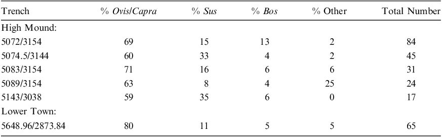
Sheep and goat are the most relatively abundant across all assemblages (59–71%), with twice as many goat (n=14) as sheep (n=7) identified. Around 50% of the sheep and goat failed to reach 18 months of age. The remainder were killed prior to reaching four years of age (note that tooth wear data is most useful here); no older individuals are noted (Fig. 41).Footnote 27
Age data from sheep and/or goat remains from MB contexts on the High Mound, derived from bone fusion (u = unfused, f = fused) and tooth wear, represented as a survivorship curve. See n. 27

Pig composed the next largest group. Individual pigs lived at least until sexual maturity, c. seven to eight months; very few animals lived past 18 months (Fig. 42). Bones of cattle compose small portions (less than 13%) of the assemblages, all of which were bones of the skull or extremity. A total of eight bones from equids were recovered (more specific identifications were not possible). As with cattle, nearly all bones were of the skull or extremity.
Age data from pig remains from all MB contexts, derived from bone fusion (u = unfused, f = fused) and tooth wear, represented as survivorship curve

In High Mound North Slope trench 5089/3154, a lower permanent equid second pre-molar displayed unusual wear on its anterior surface (6.84 mm long, 1.28 mm deep) that was initially examined as potential bit wear. It appears that the tooth moved against a fixed object, or perhaps an object at a fixed distance (i.e. maxillary teeth). Rather than bit wear, it is likely that this pattern is the consequence of a rostral hook on the animal’s upper, permanent 2nd premolar. While this type of wear is not uncommon in domestic equines prior to the adoption of equine dentistry methods that involved rasping away such hooks, it is notable, since additional types of wear found on individual teeth could mimic – or be misconstrued as – wear from a metal bit.Footnote 28
Three bones were recovered from canids, most probably dogs. Bones from additional species included fish (two bones), a fragment of tortoise carapace, and single bones of bird, frog, and a medium-sized carnivore, all from High Mound North Slope trench 5072/3154 (cf. area 7, Fig. 6). Two bones of hare (Lepus sp.) were recovered and a single deer antler piece also from the High Mound North Slope.
Single bones of rodents were found in the High Mound North Slope trenches, and several rodent skeletons were recovered from 5083/3154-043 (area 8 on Fig. 6). This group was found on a burned floor that had been covered by mudbrick collapse. Amid burned bones from sheep, goat, cattle and equid were the remains of a minimum of five rodents belonging to a species of the genus Meriones (jird). Included were one adult and four juveniles, likely a mother and single litter of four. The skeletons were found grouped in a way to suggest a nest. It is unclear whether the jirds and their nest had been present on the floor during human occupation (perhaps in an area not often visited by the occupants), or whether the rodents occupied the fallen roof.
Lower Town East, Temple, Trench 5648.96/2873.84: The assemblage from the ‘temple’ building on the Lower Town East differs from other parts of the MB settlement in the restricted range of bones found. The assemblage is heavily dominated by sheep and goat remains – at 80%, more so than any other area. Two bones – both astragali – have been identified as goat; no sheep have been so discriminated. Discrimination between bones of sheep and goat is difficult for younger animals, given the lack of morphological development of their bones, and many of those recovered from the temple area remain undistinguished between sheep and goat. The ovicaprids from here are also among the youngest on average recovered from the site. Of the bones from which age data could be gleaned, only two were recovered from animals that were over one year of age at death (as indicated by their completed fusion), while all teeth indicated death within the first year (Fig. 43). Although bones were also recovered from non-infant animals, most of those specimens were heavily fragmented and primarily composed of long-bone segments, with no portion of their articular region present to clearly assess age; bone thickness and texture simply indicate that these animals were not infants but could have been subadults. This ‘older’ material was also found in mixed deposits that included bones of cattle, pig, and equid. The very young animals were isolated in more discrete deposits.
Age data from sheep and/or goat remains from MB contexts on the Lower Town East, derived from bone fusion (u = unfused, f = fused) and tooth wear, represented as survivorship curve
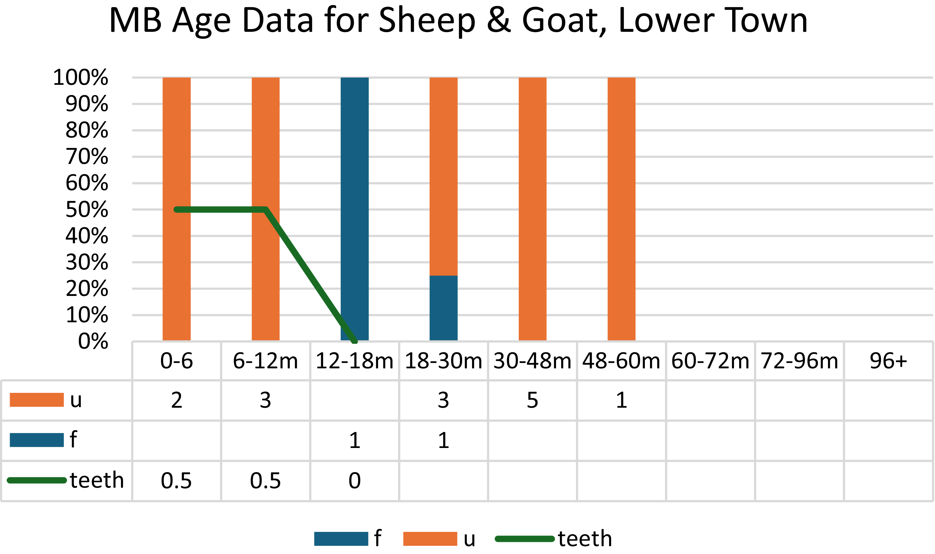
Notable among these bones is a deposit within a ‘passageway’ between two areas of the building (see Fig. 22) from which were recovered neonatal and infant sheep/goat bones from a minimum of three individuals. All parts of the body except carpals, tarsals, and phalanges were recovered among the infant remains. The very small size of the bones, as well as the age information derived from teeth, indicate that these were young infants. Teeth from this deposit included an unerupted, mandibular deciduous fourth premolar, indicating death within the first two months of life. Below these materials in the passageway were teeth of a sheep or goat c. 6–12 months of age at death, as well as single fragments of cattle and pig bones and a gerbil skeleton.
Additional neonatal remains of sheep/goat (one metatarsal and one ulna) were excavated from contexts below the present-day mound surface. It is unclear if these are related to the passageway or derive from additional deposits of very young animals.
In the temple, pig bones were limited to a single deposit of neonatal bones, plus a few other fragments. There is little overlap between pig bones and those of sheep/goat. Large-sized mammals, primarily cattle and equid, were very limited. Of these, one long bone fragment had been intentionally modified during production of a bone implement or pin; it had the typical prismatic shape of the longitudinal sections that had been removed from cattle and equid long bones being prepared for raw material utilization in LB levels at the site (Schwartz et al. Reference Schwartz, Brinker, Creekmore, Feldman, Smith and Weber2017: 245–246); this marks the first find of prismatic debris from MB levels.
Bones from large-sized mammals were not recovered from the contexts with infant and juvenile sheep, goat, or pig.
The disparity in deposition between younger and older animals suggests different uses or purposes for their remains. Among all animals, the greatest range of elements, including skull and axial elements, is found among the youngest animals – neonates and infants; their bones are recovered as whole elements, except where broken in excavation. Very young animals (0–6 months at death) appear to have been deposited whole without any processing and segregated from other animal remains (including other genera) and deposits.
Lower Town East, Trench 5434/3092: Trench 5434/3092 is an area in the possible palace with baked brick structures and storage jars. These work (?) areas are bordered by an exterior zone, possibly a street, composed of pebbles and sherds. Only 71 bone fragments were recovered, the majority of which (n=55) belonged to medium-sized mammals. Sheep and goat (n=7), pig (n=3), and dog (n=1) were identified. Among the large-sized mammal bones were those of cow (n=2) and equid (n=3). Although age data are scant, the animals appeared to be somewhat older than those in the temple area.
Among the fragmented remains were indications of the use of bone as raw material, from both medium- and large-sized mammals. A ‘punch’ or awl fashioned from a medium-sized mammal long bone was found in debris above the west wall of the area 4 sunken baked brick feature (Fig. 15). A second piece of worked bone was found inside the same feature and consisted of a cattle metatarsal ‘blank’, as was standard for preparing long bones for pin production in the LB bone workshop on the High Mound East (Schwartz et al. Reference Schwartz, Brinker, Creekmore, Feldman, Smith and Weber2017: 245–246). This waste, in addition to the prismatic section from the temple, indicates that the bone workshop found in the LB period is a continuation of the use of this raw material for pin production at the site.
The largest concentrations within the assemblage examined were recovered from the area 4 baked brick feature and the eastern, higher part of the area 3 baked brick platform. These bones, and the whole assemblage, were of the same range of animals found in other areas. There is evidence that whole animals (or all parts) entered the area, and long bones remained and were subject to heavy processing. This might indicate attempts to capture grease from the bones, as well as to remove (curate) those useful as raw material.
Overall, it does not seem that rubbish accumulated here. Rather, the location near a street may have facilitated removal of waste, particularly animal carcasses and parts that may have had a strong odor. Despite the scant remains, it seems probable that the area was a clearinghouse for animals/meat/raw material entering the building.
Lower Town East, Trench 5462/3192: This open area contained a baked brick platform along with synthetic basalt objects and a large number of fragmented storage jars. The analyzed sample consisted of just six bones, which were solely from medium-sized mammals, of which only sheep or goat were positively identified. Age data from two bones indicated juvenile animals. While it is currently unclear why there are so few bones in the sample, lower town areas are generally in closer proximity to land used for both formal or informal rubbish-dumps, including streets and areas outside of town. As a result, less rubbish may have accumulated in such areas.
Late Bronze Age
LB contexts were excavated on the High Mound North Slope (domestic remains, trenches 5074.5/3038, 5083/3154, and 5089/3154) and the High Mound East (domestic and industrial remains, trench 5143/3038). Overall, the assemblage is heavily domestic, as was the case in MB, and it was strongly dominated by medium-sized mammals, with 95% consisting of Ovis aries (sheep), Capra hircus (goat), Sus scrofus domesticus (pig), and Bos taurus (cattle). The remaining 5% includes Canis sp. (dog and relatives), Equus sp., roe deer (Capreolus capreolus), a small carnivore, Rana sp. (frog), and rodent (Table 3).
Relative abundance of main faunal taxa by LB excavation area

Excluding 5089/3154, whose sample size (n=12) is too small to be meaningful, sheep and goat made up at least 50% of the main domesticates in each trench, followed by pig (23–32%) and cattle (0–9%). No strong predilection for goat over sheep was visible, in contrast to previous years’ results. Sheep and goat of all ages were recovered, but about 50% of the individuals from the High Mound did not live beyond their third or fourth year (Fig. 44).
Age data from sheep and/or goat remains from LB contexts, derived from bone fusion (u = unfused, f = fused) and tooth wear, represented as survivorship curve

Pig bones were found in relatively large numbers, particularly in High Mound East trench 5143/3038 (32%), with data indicating that individuals from that trench did not live past their third year (Fig. 45, note that all bones recovered whose fusion occurs beyond 3 years of age were unfused). The cattle remains, usually of adults, were primarily concentrated in 5143/3038. Elements are heavily skewed toward bones of the skull and extremities.
Age data from pig remains from LB contexts, derived from bone fusion (u = unfused, f = fused) and tooth wear, represented as survivorship curve
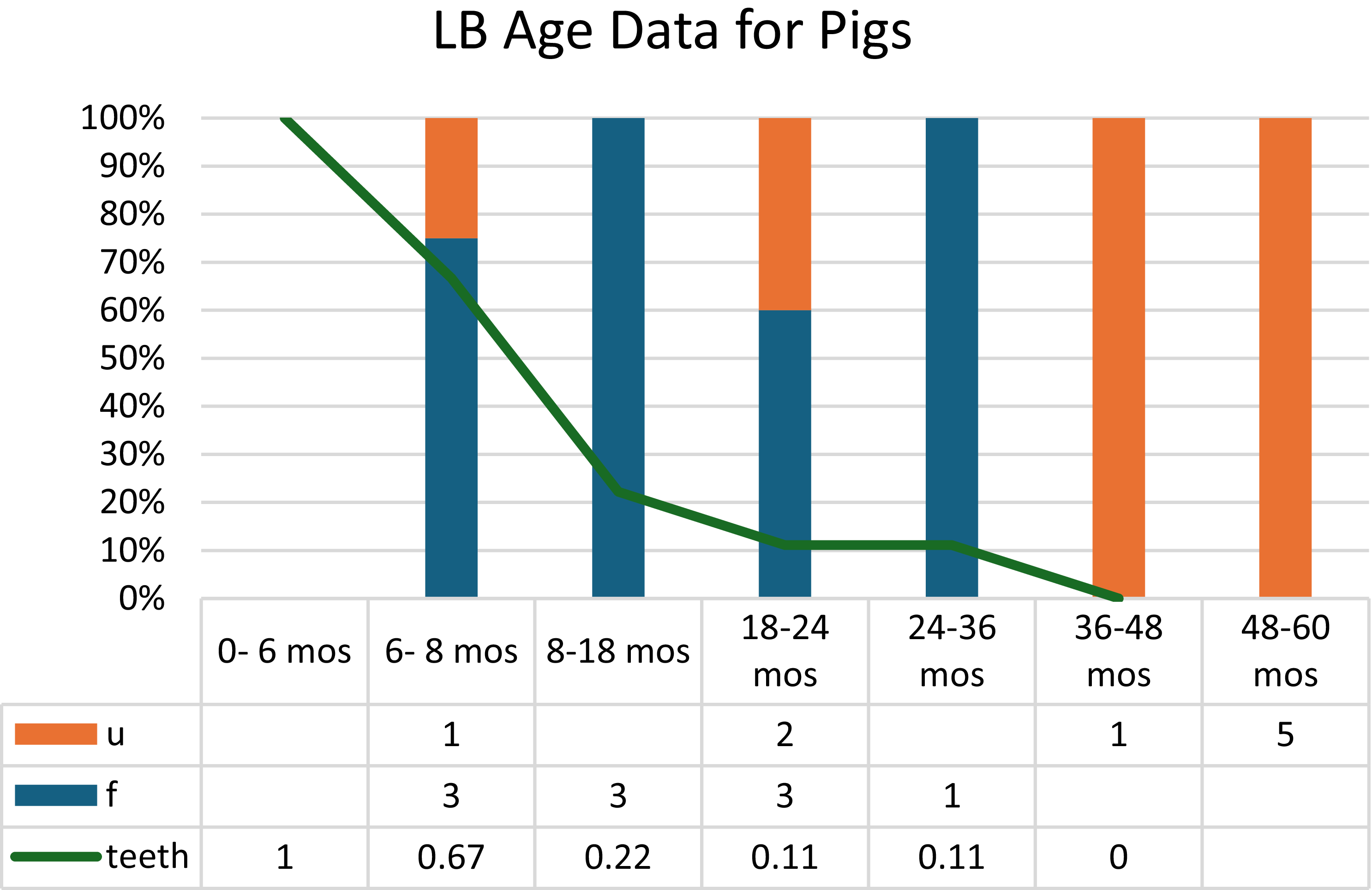
Spatial differences between areas, though strong, are mitigated by varying and small sample sizes. The biggest differences are found between High Mound North Slope trench 5074.5/3038 and the other three trenches. In 5074.5/3038, only sheep, goat and pig were identified, including some juvenile and neonatal individuals. Unlike the other trenches, no cattle, dog, or equid was found, and bones of large-sized animals were almost completely absent.
Aside from the limited range of animals found in 5074.5/3038, another difference was noted in the distribution of elements. While there was a strong bias for bones of the skull and extremities in 5089/3154, 5083/3154, and especially 5143/3038, such a bias was not apparent in 5074.5/3038. Further, in 5089/3154, 5083/3154, and 5143/3038, long bones of sheep, goat, pig, cattle and dog had been heavily processed, but this pattern of fragmentation was less notable in 5074.5/3038.
These similarities and differences between trenches mirror contextual variation. Thus, High Mound East trench 5143/3038 contains industrial-looking installations with baked bricks, a gutter, and a large basin as well as remains of synthetic basalt, slag, and ashy soils. While High Mound North Slope trenches 5089/3154 and 5083/3154 do not have similar installations, they do contain the remains of similar activity – including slag, synthetic basalt and ashy soils, and indications of possible use for food preparation. The activities occurring in this area resulted in faunal waste of predominantly skulls and extremities. These elements were removed or set aside and then discarded without further processing. These parts of the body have little meat, with the exception of the brain and tongue, which can be accessed with splitting of the skull and removal of the mandible. Although skulls and extremities are often associated with skins, no patterned butchery indicative of skin removal was identified. It is possible these areas functioned as ‘clearinghouses’ for whole carcasses moving through the High Mound.
Evidence for the presence of the whole carcass – and the ensuing reduction into parts to be meted out or sent elsewhere – can be found in a fairly complete juvenile goat skeleton in High Mound North Slope trench 5143/3038, as well as in the presence of articulated ‘waste’ such as an axis and other cervical vertebrae of a dog in the same trench. The juvenile goat skeleton contained skull, axial elements (such as vertebrae) and extremities; the limbs had been removed. By contrast, High Mound North Slope trench 5074.5/3038 appeared more domestic in nature and does not seem to have been a movement point for animal carcasses or raw materials.
LB pit graves: Pit graves dating to LB levels on the High Mound sometimes included animal bones. On the High Mound North Slope, grave 5074.5/3144-004 had two left and one right complete patella (knee) bones from a minimum of three sheep or goat. In addition, post-depositionally fragmented remains of a minimum of three femur bones from sheep or goat were also recovered. Pit grave 5083/3154-011 contained bones of the skull and the extremities from sheep and possibly goat. The mostly complete skeleton of a frog (Rana sp.) was also identified. Left and right mandible, astragalus, and phalanx fragments from a single individual, most likely a sheep, were aged at 12-18 months at death.
Excavations in 2017 on the High Mound North Slope had also revealed an LB pit grave (5078/3154-017) containing animal bones. That burial contained human bones of one adult and one child as well as four large baked-clay figurines (Schwartz et al. Reference Schwartz, Creekmore, Smith, Weber and Webster2022: 201). Animal bones were recovered from a minimum of four individual sheep and/or goat. The youngest animal was no more than six months old at death, while the other three were slightly older but still young juveniles. One was identified as a sheep.
On the High Mound East, pit grave 5143/3038-035 contained only a few animal bone fragments, one from a sheep. No animal bones were found in infant grave 5143/3038-015.
Taken together, the pit graves from 2022, along with fortifying material from 2017, indicate that adult human burials on the High Mound were typically accompanied by a select range of animal bones, usually of sheep. The remains are of select parts of animals rather than complete individuals and were in their first or second year of life.
Conclusions
Recovery of bones from an ever-growing diversity of contexts has expanded our understanding of intra-site variation in bone deposits, while also highlighting continuity in aspects of their exploitation. Domestic animals continue to figure prominently in the animal remains from Kurd Qaburstan, with goat, sheep, pig, and cattle by far the dominant animals in MB and LB (Fig. 46). Faunal data from contemporaneous levels at other nearby settlements are scant, but we can note that remains from Bakr Awa in the foothills southeast of Sulaymaniyah are also heavily domestic in MB and LB (Piątkowska-Małecka Reference Piątkowska-Małecka2015). Closer to home at Surezha, just 2 km north of Kurd Qaburstan, the Ubaid and Late Chalcolithic occupations also show a strong reliance on domestic animals that Price et al. (Reference Price, Fisher and Stein2021) relate to wide-scale trends at that time.
Relative abundance of the three main taxa by period
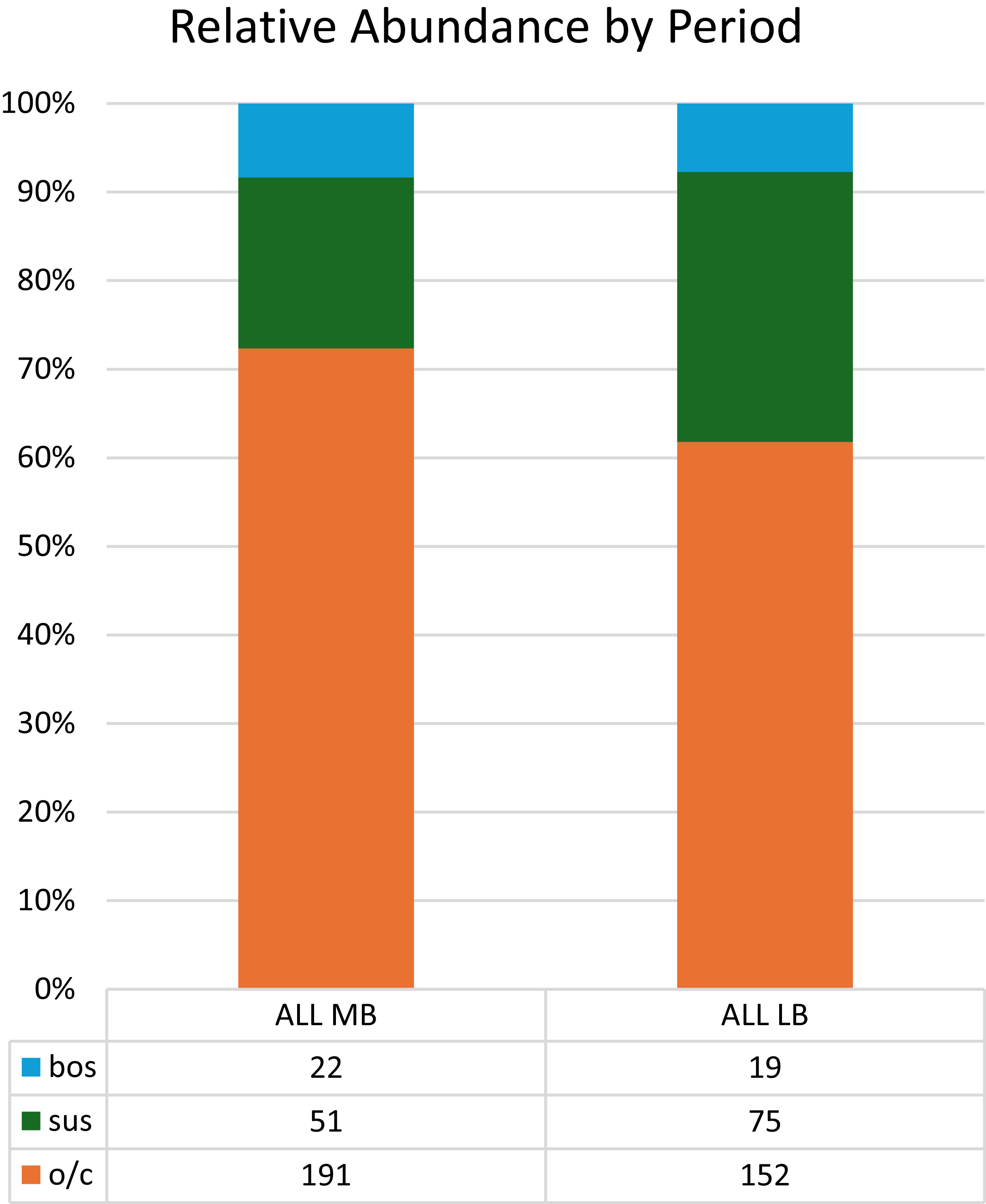
As previously observed, animal bones at Kurd Qaburstan were heavily processed, with few long bones left whole. More data for the use of bone as a raw material were recovered, increasing the evidence for formal tool and pin production focused on large-mammal long bones.
Until the 2022 excavations, very few distinctions had been noted in the range of taxa and ages deposited between areas. The newly-analyzed assemblages from the LB pit burials and the MB temple differ from other, contemporary contexts in their restricted ranges of age and taxa. To date, only sheep have been positively identified from LB burials. These occur as partial skeletons with a select array of limb and skull bones and were usually killed in their first year.
In the MB temple, young sheep and/or goat heavily dominated (80%) the assemblage, with almost all under one year of age at death, including several fetal and neonatal individuals. The neonates and infants (under one year of age) were deposited/discarded whole, while those over one year were processed further. This situation is reminiscent of the tomb findings from EB Umm el-Marra in Syria, where the youngest animals were deposited complete and the older animals as butchered parts (Weber Reference Weber and Schwartz2024: 650). Whole ovicaprids were appropriate gifts for communication and diplomacy in ancient Syro-Mesopotamia (Jacobsen Reference Jacobsen1991; Katz Reference Katz2003), with emphasis placed on unblemished animals (Kramer Reference Kramer1967: 111). The unique presence of very young (unblemished?) animals in association with the temple perhaps indicates a selection intended for ritualized communication and gifting with supernatural entities or temple personnel.
The disposition of pigs in LB urban households remains a question of great interest. Texts from Nuzi indicate that pig’s lard was a commodity to which female members of households had access (Lion Reference Lion and Wilhelm2009). Pig exploitation thus offers insight into a less visible economic activity, one predicated on small-scale pig-keeping ‘in the garden’. Since it was pig’s lard that formed the commodity, facilities for its production must have existed.
Possible evidence for this kind of pig exploitation may be present at Kurd Qaburstan. LB contexts excavated in 2022 include numerous work areas with baked bricks, basins, and channels, adding to previous evidence for craft production focusing on animal bones as raw materials. Given the heavy processing of animal carcasses, it is likely that the skins and fats were also exploited; smashing of bones is a method to access fats and collagen. While we do not know yet what occurred in these spaces, butchering, curating of fat, and rendering into lard or tallow are all possible activities (e.g., Karr et al. Reference Karr, Short, Hannus and Outram2014). Pig bones were among the remains found in these areas along with bones of sheep, goat, cow, and dog; all taxa were heavily processed. Generally, texts suggest that it was sheep’s fat, not pig’s, that was typically utilized (Lion Reference Lion and Wilhelm2009: 274), though many attestations of the use of pig’s fat occur in the texts from Nuzi (Schneider-Ludorff Reference Schneider-Ludorff, Owen and Wilhelm1999: 405, 407), in relatively close proximity to Kurd Qaburstan. Preferential exploitation of pig’s fat over sheep’s fat could explain the large numbers of pig on the high mound, deriving from small herds for women of elite households. This could account for the predominance of goat in this non-arid environment, in which sheep would normally be expected to thrive. The findings from LB pit graves indicate that sheep were preferred for uses that might be ritualized, such as in burials. This use may have further precluded their availability (or suitability?) for fat exploitation. Our LB findings give tantalizing evidence to suggest that pigs, and specifically pig’s lard, were utilized as a commodity, akin to their noted use in Nuzi texts by elite women. Ultimately, lipid and fat analysis will be necessary to assess this economic activity.
Archaeobotanical AnalysisFootnote 29
During the 2022 season, 24 archaeobotanical samples were collected spanning the MB (n = 11) and LB (n = 13) periods, from a range of archaeological contexts representing building collapse, occupational debris, pits, burials, and the contents of jars (Table 4). A total of 189.5 L of sediment was floated, with sediment volume varying between 3 and 14 L per sample, with a mean of 7.9 L. Sediment samples were processed in the field by excavators using a bucket flotation system. A total of 769 ml of light fraction/flot was recovered, with floated assemblages ranging from 0.1–310 ml. Light fractions were transported to the Archaeobotany Laboratory at the University of Connecticut for analysis by Alexia Smith. After modern contaminants had been removed, light fractions were weighed and then sieved using 4 mm, 2 mm, and 1 mm sieves to facilitate sorting. Each size fraction >1 mm was fully sorted. Remains <1 mm were fully scanned and any identifiable plant part removed for further examination.
Archaeological context information for flotation samples examined; HMNS = High Mound North Slope, HME = High Mound East, LTE = Lower Town East; Phase 1 is the most recent, and Phase 5 the oldest
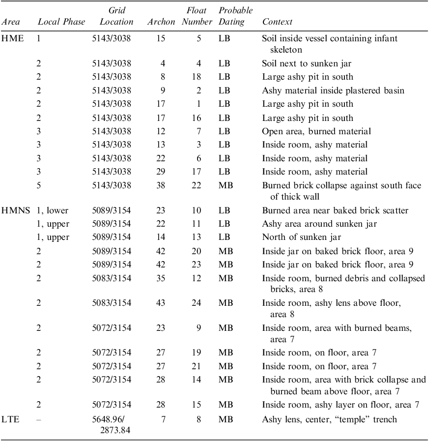
Table 4: Long description
The table presents archaeological context information for flotation samples examined, with columns for Area, Local Phase, Grid Location, Archon, Float Number, Probable Dating, and Context. It includes data for different areas such as HME, HMNS, and LTE, with specific grid locations and phases. Each row provides detailed context information for the samples collected. Row 1: Area, HME; Local Phase, 1; Grid Location, 5143/3038; Archon, 15; Float Number, 5; Probable Dating, LB; Context, Soil inside vessel containing infant skeleton. Row 2: Area, HME; Local Phase, 2; Grid Location, 5143/3038; Archon, 4; Float Number, 4; Probable Dating, LB; Context, Soil next to sunken jar. Row 3: Area, HME; Local Phase, 2; Grid Location, 5143/3038; Archon, 8; Float Number, 18; Probable Dating, LB; Context, Large ashy pit in south. Row 4: Area, HME; Local Phase, 2; Grid Location, 5143/3038; Archon, 9; Float Number, 2; Probable Dating, LB; Context, Ashy material inside plastered basin. Row 5: Area, HME; Local Phase, 2; Grid Location, 5143/3038; Archon, 17; Float Number, 1; Probable Dating, LB; Context, Large ashy pit in south. Row 6: Area, HME; Local Phase, 2; Grid Location, 5143/3038; Archon, 17; Float Number, 16; Probable Dating, LB; Context, Large ashy pit in south. Row 7: Area, HME; Local Phase, 3; Grid Location, 5143/3038; Archon, 12; Float Number, 7; Probable Dating, LB; Context, Open area, burned material. Row 8: Area, HME; Local Phase, 3; Grid Location, 5143/3038; Archon, 13; Float Number, 3; Probable Dating, LB; Context, Inside room, ashy material. Row 9: Area, HME; Local Phase, 3; Grid Location, 5143/3038; Archon, 22; Float Number, 6; Probable Dating, LB; Context, Inside room, ashy material. Row 10: Area, HME; Local Phase, 3; Grid Location, 5143/3038; Archon, 29; Float Number, 17; Probable Dating, LB; Context, Inside room, ashy material. Row 11: Area, HME; Local Phase, 5; Grid Location, 5143/3038; Archon, 38; Float Number, 22; Probable Dating, MB; Context, Burned brick collapse against south face of thick wall. Row 12: Area, HMNS; Local Phase, 1, lower; Grid Location, 5089/3154; Archon, 23; Float Number, 10; Probable Dating, LB; Context, Burned area near baked brick scatter. Row 13: Area, HMNS; Local Phase, 1, upper; Grid Location, 5089/3154; Archon, 22; Float Number, 11; Probable Dating, LB; Context, Ashy area around sunken jar. Row 14: Area, HMNS; Local Phase, 1, upper; Grid Location, 5089/3154; Archon, 14; Float Number, 13; Probable Dating, LB; Context, North of sunken jar. Row 15: Area, HMNS; Local Phase, 2; Grid Location, 5089/3154; Archon, 42; Float Number, 20; Probable Dating, MB; Context, Inside jar on baked brick floor, area 9. Row 16: Area, HMNS; Local Phase, 2; Grid Location, 5089/3154; Archon, 42; Float Number, 23; Probable Dating, MB; Context, Inside jar on baked brick floor, area 9. Row 17: Area, HMNS; Local Phase, 2; Grid Location, 5083/3154; Archon, 35; Float Number, 12; Probable Dating, MB; Context, Inside room, burned debris and collapsed bricks, area 8. Row 18: Area, HMNS; Local Phase, 2; Grid Location, 5083/3154; Archon, 43; Float Number, 24; Probable Dating, MB; Context, Inside room, ashy lens above floor, area 8. Row 19: Area, HMNS; Local Phase, 2; Grid Location, 5072/3154; Archon, 23; Float Number, 9; Probable Dating, MB; Context, Inside room, area with burned beams, area 7. Row 20: Area, HMNS; Local Phase, 2; Grid Location, 5072/3154; Archon, 27; Float Number, 19; Probable Dating, MB; Context, Inside room, on floor, area 7. Row 21: Area, HMNS; Local Phase, 2; Grid Location, 5072/3154; Archon, 27; Float Number, 21; Probable Dating, MB; Context, Inside room, on floor, area 7. Row 22: Area, HMNS; Local Phase, 2; Grid Location, 5072/3154; Archon, 28; Float Number, 14; Probable Dating, MB; Context, Inside room, area with brick collapse and burned beam above floor, area 7. Row 23: Area, HMNS; Local Phase, 2; Grid Location, 5072/3154; Archon, 28; Float Number, 15; Probable Dating, MB; Context, Inside room, ashy layer on floor, area 7. Row 24: Area, LTE; Local Phase, -; Grid Location, 5648.96/2873.84; Archon, 7; Float Number, 8; Probable Dating, MB; Context, Ashy lens, center, temple trench.
All seeds, fragments, and plant parts were identified to the most specific taxonomic rank possible using the reference collection in the Archaeobotany Laboratory at the University of Connecticut, which is rich in flora from Southwest Asia. Various flora, seed identification manuals, and archaeobotanical reports were also used to assist with identifications and provide ecological and ethnobotanical information (e.g., Bor Reference Bor, Townsend, Guest and Al-Rawi1968; Davis Reference Davis1965–1985; Nesbitt Reference Nesbitt2006; Townsend and Guest Reference Townsend and Guest1974; van Zeist and Bakker-Heeres Reference van Zeist and Bakker-Heeres1984 (1986), Reference van Zeist and Bakker-Heeres1985 (1986)). Intact plant parts, such as whole seeds, achenes, nutlets, and spikelet forks were counted as one, as were individual culm, and rachis fragments. Leguminous seeds that had both cotyledons present were also counted as one. Following the approach used by Colledge (Reference Colledge2001: 66) for fragmented cereal grains, the number of apical and embryo fragments were counted and the largest value was used as an estimate for whole grains.
Anthracological Remains
After sorting, wood fragments were separated for anthracological analysis. Lucas Proctor examined wood charcoal from 14 select flotation samples spanning the 2017 and 2022 seasons. The 2017 season samples (see Schwartz et al. Reference Schwartz, Creekmore, Smith, Weber and Webster2022: Tables 2–4) included 1, 26, 29, and 32 dating to the MB (representing debris over brickwork, debris inside a room, a charred area above a floor, and roof collapse) and 4 and 23, 17, and 19 dating to the LB (representing fill of room, an area near a baked brick line, and charred pit fill respectively). Further details of the contexts and associated macrobotanical remains from the 2017 field season are provided in Schwartz et al. Reference Schwartz, Creekmore, Smith, Weber and Webster2022. The 2022 season flotation samples 9, 19, 21, 23, and 24, dating to the MB, and sample 16, dating to the LB, are described in Table 4 and more fully below alongside the non-woody plant remains.
Prior to analysis of individual wood charcoal pieces, >4 mm fragments were counted and weighed. Fragments were then sectioned along their transverse, radial, and tangential axes to reveal intact anatomy as needed for identification, following standard anthracological methodology. Specimens were examined under reflected light and darkfield microscopy and compared to modern reference material available in the University of Connecticut Archaeobotany Laboratory reference collection and published reference guides (e.g., Akkemik and Yaman Reference Akkemik and Yaman2012; Schweingruber Reference Schweingruber1990).
Six of the 14 samples examined contained identifiable >4 mm charcoal fragments (2017 season: samples 1 and 32; 2022 season: samples 16, 19, 23, 24). In total, 216 fragments were analyzed, with all but one identified as Salix/Populus. The remaining fragment (from sample 16) was an indeterminate angiosperm twig. Two additional MB samples thought to represent the remnants of charred structural beams (samples 9 and 21 within 5072/3154, HMNS) also contained large quantities of Salix/Populus wood charcoal. Sample 21 was particularly large, containing 69.79 g of wood fragments, and represented the only pure wood charcoal assemblage recovered via flotation; all remaining samples contained mixtures of seeds and wood. From a wood anatomical perspective, Salix (willow) and Populus (poplar/aspen) have very similar morphology and can be challenging to distinguish in charcoal. Differentiation of the two genera depends on whether rays are homocellular procumbent or heterocellular with procumbent body cells and a single row of square/upright cells on their margins.
Both poplar and willow are common components of riparian woodland vegetation throughout northern Mesopotamia and form major components of wood charcoal assemblages dating to the Middle and Late Bronze Ages throughout the region (Deckers and Pessin Reference Deckers and Pessin2010). Both species provide valuable timber and fodder and can be used to create windbreaks/erosion control for agricultural fields and settlements. Managed poplar coppices are important traditional sources of timber and firewood in the region today, and poplar timber is commonly used as beams for roofing traditional mudbrick buildings throughout Southwest Asia.
Middle Bronze Age Plant Remains
The 11 MB samples were recovered from 78.5 L of sediment, yielding just over 111.9 g and 534 ml of light fraction (Table 5). The light fraction recovered via flotation varied in size from 0.1 to 310 ml (0.06–69.79 g); such variation is common in Southwest Asian settlements of this age, potentially reflecting differences in the spatial abundance of plants within a structure and/or differential exposure to fire that enables macro-remains to preserve. Differences in the original volume of sediment collected also influence the amount, and potentially the type, of charred remains recovered, but the remains are generally assumed to reflect the archaeological context from which they were excavated. This variation is discussed further below. The sole sample from the Lower Town East, representing an ashy lens within the Temple area (sample 8, 5648.96/2873.84), was essentially sterile, containing just a few commonly encountered weed seeds (Table 5). This is common for ashy lenses, likely reflecting high temperatures that burn plant remains completely. Such samples may be better suited to phytolith analysis. Similarly, the sole Phase 5 MB sample collected from the High Mound East (22, 5143/3038), representing collapsed burned brick, was also sterile. While plant remains can preserve in mudbrick, they are often best preserved in phytolith form.
Middle Bronze archaeobotanical remains
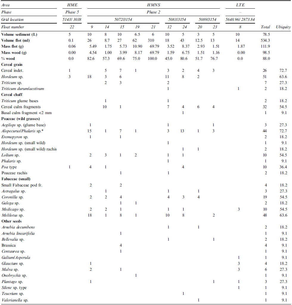
* Caryopses exhibited lateral compression and an angled embryo that seemed consistent with Alopecurus sp.; Phalaris sp. caryopses are similar with subtle differences in shape, so could not be entirely ruled out.
The remaining nine samples came from the large building on the High Mound North Slope and were dominated by wood. As noted above, due to its size and layout, this building is thought to have served a public or elite function. The samples were generally relatively rich, although two samples collected from the interior of a jar (samples 20 and 23) contained only sparse plant remains and likely represent the background noise of plants commonly encountered in the area. Sediment excavated from jars typically represents post-depositional fill unless the vessels experienced sustained charring in antiquity, allowing any organic contents to carbonize. As noted above, evidence of burned wooden and mud roofing material and other charred debris was observed by excavators, indicating that the building had been destroyed. While the structure appears to have been destroyed via a conflagration resulting in excellent catastrophic preservation of wood charcoal, the fire does not appear to have impacted the jars. Additionally, the room appears to have been emptied prior to the fire, so it is possible that if any jars did contain plants, they were also emptied.
Compared with the LB plant remains described below, the paucity of domesticates within the MB samples is notable (small proportions of cereal grain and chaff remnants were present but tend to be common across the site). The relative lack of domesticates is not too surprising, however, given the structural nature of the remains in the High Mound North Slope. In addition to evidence for Salix/Populus beams associated with the roof, large numbers of small culm fragments were observed in the <1 mm fraction of samples 12, 15, 19, 20, 23, and 24 from the High Mound North Slope. Owing to their small size and fragile state, it was not possible to identify them further, and they were very difficult to quantify. They were notably present nonetheless, differing from other samples across the site and likely represent plants used to create a mud and vegetal roof. Isolated >2 mm culm fragments resembling reeds were also preserved.
While the MB remains were dominated by wood, 35 non-woody taxa were recorded, representing mostly small wild grasses and wild legumes (such as Melilotus and Coronilla sp.; note: common names are not provided for genera-level identifications where a wide range of common names exist within the genus). The most common wild grass observed was identified as Alopecurus/Phalaris sp.; caryopses exhibited lateral compression and an angled embryo that seemed most consistent with Alopecurus sp., but given the subtle differences between the two genera and the potential for minor shape modification during charring, Phalaris sp. could not be entirely ruled out (Nesbitt Reference Nesbitt2006). These grasses and small legumes are routinely encountered in the region, and it is possible that they were growing on the roof at the time the High Mound North Slope structure was destroyed, since plants frequently grow on mud and vegetal roofs. In some instances, such growth is encouraged to modify the insulating properties of the roof. Alternatively, the plants may have been incorporated into the roof in ‘straw’ form as part of the construction. It is currently difficult to differentiate between these two interpretations from the flotation samples alone.
While roofs would clearly have been commonplace, detailed archaeological understanding of their construction is somewhat lacking relative to other aspects of construction including mudbrick composition and wall placement. As Friesem et al. (Reference Friesem, Tsartsidou, Karkanas and Shahack-Gross2014) and Kreimerman and Shahack-Gross (Reference Kreimerman and Shahack-Gross2019) note, compared with studies of floors and mudbrick composition, relatively little is known about roofs, and more work is needed to fully document them archaeologically. The association of weedy plant taxa with the roof construction at Kurd Qaburstan, while not surprising, is interesting given the paucity of archaeobotanical reports detailing roofs. The geophysical magnetometer survey mentioned earlier in this report noted higher levels of magnetism within some interior spaces, likely correlating with additional roof collapse, ash deposits, or baked brick features, so additional explorations of roof construction techniques integrating micromorphology with macro- and micro-botanical studies are possible in the future.
Late Bronze Age Plant Remains
The 13 LB samples were recovered from 111 L of sediment, collectively yielding just over 35.2 g and 235 ml of light fraction (Table 6). The floated light fractions varied in size from 2 to 75 ml (0.41–7.11 g). Ten samples were recovered from High Mound East trench 5143/3038, which had industrial and domestic remains. The samples derived from LB Phase 3 (n = 4), Phase 2 (n = 5), and Phase 1 (n=1). Compared with the MB, the LB material contained a wider variety of plant taxa (68 different non-woody taxonomic categories in total), greater proportions of cereal grains and chaff along with other domesticates, and much smaller proportions of wood within flotation samples, indicating the largely domestic nature and mundane preservation of the assemblage. This contrasts notably with the MB remains that reflect catastrophic preservation of architectural remains.
Late Bronze archaeobotanical remains
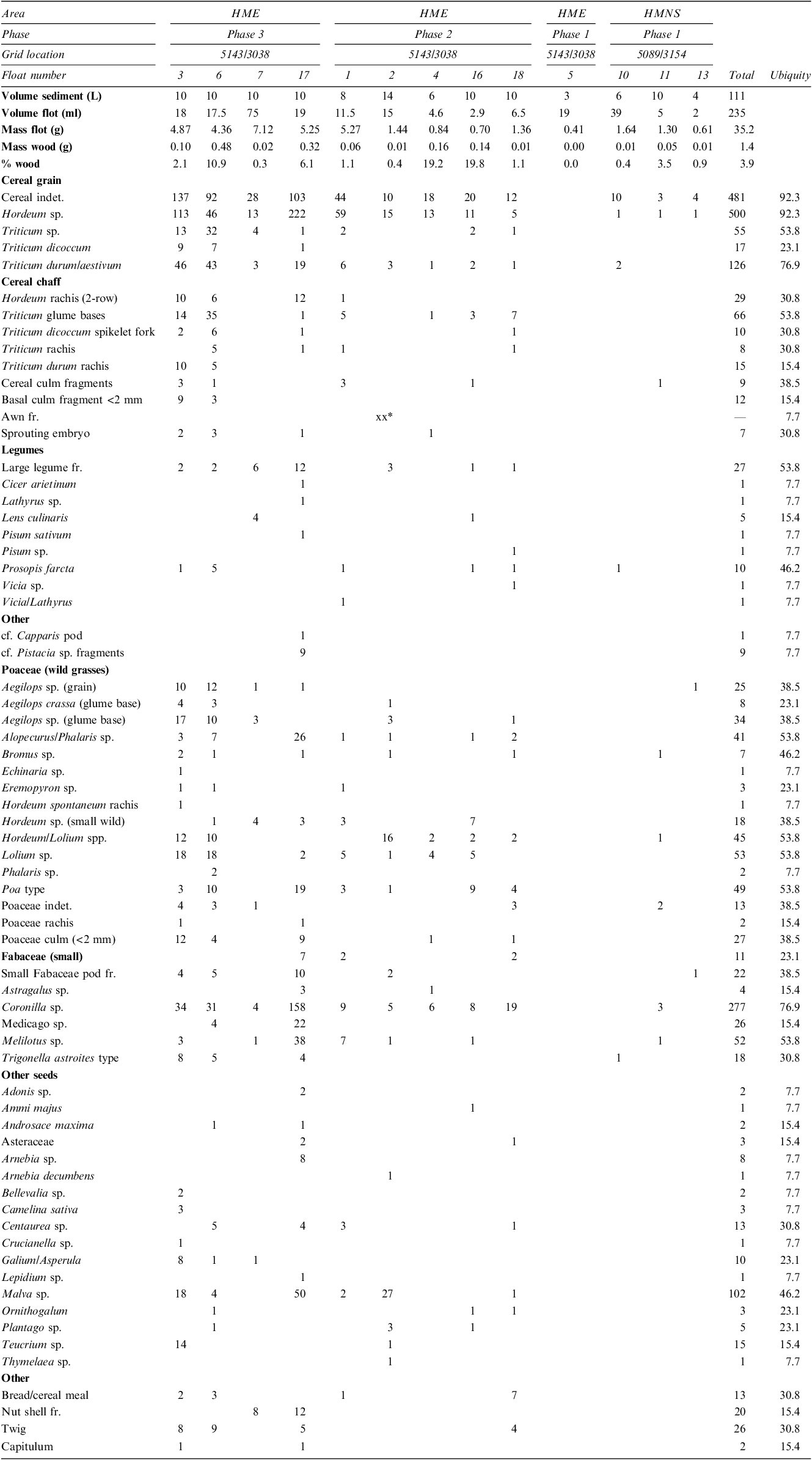
* xx = many friable remains too difficult to quantify (>30).
HME Phase 3: Four Phase 3 samples were recovered from a room filled with ashy lenses in the northeast part of High Mound East trench 5143/3038, located south and southeast of the area 5 bath (Table 6, samples 3, 6, 7, and 17). Of all the archaeobotanical samples examined from the 2022 season, these four samples yielded the most taxonomically diverse plant assemblages, sharing parallels with the Phase 3 samples recovered from debris of room 9 excavated in 2017 within 5138/3051 on the High Mound East (Schwartz et al. Reference Schwartz, Creekmore, Smith, Weber and Webster2022). The four samples were dominated by cereal grains but also included a range of other domesticates and weedy taxa not observed within the MB samples. Many of the grains were too poorly preserved and fragmented to be identified to genus. Of the identifiable grains, Hordeum (barley) was the most abundant and ubiquitous, with lesser amounts of wheat, mirroring trends observed elsewhere across the site during the 2014 and 2017 seasons (Schwartz et al. Reference Schwartz, Brinker, Creekmore, Feldman, Smith and Weber2017, Reference Schwartz, Creekmore, Smith, Weber and Webster2022). Of the wheat grains, Triticum durum/aestivum (durum/bread wheat) was the most abundant, with lesser amounts of emmer, T. dicoccum. It is difficult to differentiate between durum and bread wheat based on the grain alone, but the species can be separated via observations of the rachis fragments (Zohary et al. Reference Zohary, Hopf and Weiss2012: 32). The presence of small numbers of Triticum durum rachis fragments in Phase 3 samples 3 and 6 indicates use of durum wheat during the Late Bronze Age. A single T. aestivum rachis fragment was recovered from an MB ashy pit excavated during the 2014 season, so both taxa are represented at Kurd Qaburstan (Schwartz et al. Reference Schwartz, Brinker, Creekmore, Feldman, Smith and Weber2017: 35). Of the two taxa, durum wheat is the most drought-tolerant. In addition to rachis fragments, hulled wheat glume bases are common within the LB samples, indicating the continued use of emmer.
In addition to the higher density of domesticates and weedy taxa, the same four Phase 3 samples from the High Mound East also contained isolated fragments of bread, cereal meal, and nuts (Table 6, samples 3, 6, 7, and 17). The bread was identified by examining amorphous charred chunks using a scanning electron microscope and comparing the morphology and pore structure to a bread reference collection curated in the Archaeobotany Laboratory at the University of Connecticut. Published identification criteria were also consulted (Arranz-Otaegui et al. Reference Arranz-Otaegui, Gonzalez Carretero, Ramsey, Fuller and Richter2018; González Carretero et al. Reference González Carretero, Wollstonecroft and Fuller2017). During the 2017 season, remnants of flatbread were reported from two samples surrounding a Middle Bronze Age oven (Schwartz et al. Reference Schwartz, Creekmore, Smith, Weber and Webster2022: 224); in recent years, bread finds are becoming more commonplace, including across Iraq (e.g. Carter et al. Reference Carter, Wengrow, Saber, Hamarashi, Shepperson, Roberts, Lewis, Marsh, González Carretero, Sosnowska, D’Amico, Sagan and Lockyear2020; Wengrow et al. Reference Wengrow, Carter, Brereton, Shepperson, Hamarashi, Saber, Bevan, Fuller, Himmelman, Sosnowska and González Carretero2016).
In addition to cereal grains, crop processing debris, and bread, the Phase 3 samples from the northeast part of the trench on the High Mound East contained small numbers of poorly preserved legumes, including Lens culinaris (lentil), Cicer arietinum (chickpea), Lathyrus sp. (grass pea), Pisum sativum (pea), and Vicia sp. (vetch). Relative to cereals, they were found in smaller numbers and were not as ubiquitous, paralleling trends observed in other Phase 3 samples from the site (Schwartz et al. Reference Schwartz, Brinker, Creekmore, Feldman, Smith and Weber2017, Reference Schwartz, Creekmore, Smith, Weber and Webster2022). The relative paucity of legumes relative to cereal remains is a common pattern across Southwest Asia throughout multiple time periods. At nearby Surezha, for example, legumes were also present in small numbers during the Ubaid–Late Chalcolithic periods, with lentil being the best represented (Proctor et al. Reference Proctor, Smith and Stein2022: 8). In general, lentil is also the best represented legume at Kurd Qaburstan, followed by Prosopis farcta (poor woman’s date). Prosopis farcta is commonly encountered across Syria and Iraq (e.g., Charles Reference Charles1998; Helbaek Reference Helbaek and Mallowan1966; Weiss et al. Reference Weiss, Manning, Ristvet, Mori, McCarthy, Quenet, Smith, Bahrani and Weiss2012) and was common in LB levels recovered in earlier seasons at Kurd Qaburstan (Schwartz et al. Reference Schwartz, Brinker, Creekmore, Feldman, Smith and Weber2017: 223). The identification of a single pea and single chickpea in sample 17 marks the first observation of these taxa at Kurd Qaburstan.
The large number of Malva (mallow) seeds in Phase 3 LB sample 17 was notable. Large numbers of Malva were also observed in LB samples from the 2017 season (Schwartz et al. Reference Schwartz, Creekmore, Smith, Weber and Webster2022: 223–224), although many of those appeared to be modern. The seeds from sample 17 were undoubtedly charred. It is unclear what the plant was used for, but they accompany a distinctly domestic assemblage. In addition to having beautiful flowers, many of the plant parts can be consumed by people. The leaves have a spinach flavour, and the seeds have numerous medicinal properties, including as an anti-inflammatory (Razavi et al. Reference Razavi, Zarrini, Molavi and Ghasemi2011).
The weedy taxa in the four Phase 3 samples from the High Mound East include a range of wild grasses and small legumes that are often found in pastures (Table 6). Aegilops (goat grass) was routinely encountered, again paralleling earlier finds at the site (Schwartz et al. Reference Schwartz, Brinker, Creekmore, Feldman, Smith and Weber2017, Reference Schwartz, Creekmore, Smith, Weber and Webster2022). While it can be difficult to distinguish between Aegilops species based on grain alone, species can be separated based on observations of the spikelet bases (Charles and Bogaard Reference Charles, Bogaard, Oates, Oates and McDonald2001: fig. 324). Aegilops crassa spikelets were observed in samples 3 and 6, adding to the range of Aegilops taxa represented at Kurd Qaburstan; Aegilops tauschii spikelet bases were observed during the 2014 season (Schwartz et al. Reference Schwartz, Brinker, Creekmore, Feldman, Smith and Weber2017: 37). Of the small legumes, the relative abundance of Coronilla seeds to other taxa is quite notable. Coronilla often grows in pastures but can also be used as a forage crop (Townsend and Guest Reference Townsend and Guest1974). The use of dung fuel at Kurd Qaburstan was discussed in earlier reports (Schwartz et al. Reference Schwartz, Brinker, Creekmore, Feldman, Smith and Weber2017, Reference Schwartz, Creekmore, Smith, Weber and Webster2022), so it is entirely possible that spent dung fuel contributed in part to these samples with the remains representing animal diet, although an analysis of dung spherulites within the <1 mm fraction of the sample would be needed to positively confirm its use within this Phase 3 room (Smith et al. Reference Smith, Proctor, Hart and Stein2019).
HME Phase 2: The five samples dating to the High Mound East Phase 2 contained far fewer charred plant remains than those from Phase 3 and exhibited a greater level of modern contaminants, indicating possible disturbance, since the sediments they were recovered from lay close to the modern-day surface of the site (Table 6, samples 1, 2, 4, 16, and 18 within 5143/3038). Cereal grains continued to be abundant (barley in particular), accompanied by sporadic finds of chaff, domesticated legumes, small grasses and small legumes. Sample 4, taken close to a sunken jar, was largely sterile. Sample 1, collected from a large ashy pit (south of a baked brick square platform with a lime-plastered drain and a burned lime-plastered pit/basin), contained fragmented cereal grain that appears to have been broken prior to charring, possibly representing some form of bulghur. A similar observation was made for some of the cereal fragments dating to Phase 3, although the association was less defined for the Phase 3 samples. Samples 16 and 18, likewise from the large ashy pit in the south of the trench, also contained cereals with a fair number of wild grasses and legumes. Interestingly, sample 2, collected from ashy material inside the plastered basin, also contained highly friable remnants of awns in the <1 mm fraction. Collectively, the Phase 2 samples are consistent with spent dung fuel but could also represent admixtures of processing debris (either within the fuel or separate from the fuel) and remnants of food preparation. Future analysis of dung spherulites within the samples could help hone the interpretations (Smith et al. Reference Smith, Proctor, Hart and Stein2019).
HME Phase 1: The sole Phase 1 sample from 5143/3038 on the High Mound East came from a baby burial (Table 6, sample 5). This sample contained small amounts of modern contaminants and no charred remains at all and so was deemed sterile, although it is possible that plant remains may be preserved in phytolith form. Across Southwest Asia, baby burials rarely contain intact charred remains.
HMNS Phase 1: Three LB samples came from High Mound North Slope trench 5089/3154, largely representing sediment collected near a baked brick scatter and from around a jar (Tables 4, 6). Given the proximity of Phase 1 levels to the modern surface of the site, these three samples were heavily contaminated with modern rootlets and, in one sample, a mulch-like material. Outside of sporadic poorly preserved cereal grains and isolated weed seeds, these samples were largely sterile.
Archaeobotany Summary
Once the surface layers of the mound had been removed, the preservation of archaeobotanical remains was generally good. Samples collected from surface layers tend to be largely sterile and heavily contaminated with modern rootlets.
The remains from the MB structure from Phase 2 of the High Mound North Slope (Fig. 6) document the catastrophic destruction and preservation of mud and vegetal roof supported by Salix/Populus beams, integrated with reeds and a range of grasses and small legumes. Highly friable culm fragments were noted in the <1 mm fractions of many of the roof samples. Proportions of Alopecurus/Phalaris and Melilotus were also elevated. It is unclear whether these plants formed part of the roof or were growing on top of the roof at the time of its destruction. Either way, the clear association of these plants with the roof is interesting; discussions of roof construction seldom appear in archaeobotanical reports from Southwest Asia.
Collectively, the LB samples, in contrast, reflect a more day-to-day level of preservation, recording domestic use of a range of cereals, legumes, and weedy taxa alongside the production of bread. In High Mound East Phase 1 and High Mound North Slope Phase 1, the samples were largely sterile, but samples from High Mound East Phases 2 and 3 were more productive, yielding a mix of cereal grains, legumes, and weedy taxa. Hordeum (barley) was the most abundant and ubiquitous cereal, followed by Triticum durum/aestivum, and then T. dicoccum (emmer). Legumes were less frequently encountered and tended to be fragmented and poorly preserved but were fairly ubiquitous nonetheless. In decreasing order of occurrence, the larger legumes included Lens culinaris (lentil), Prosopis farcta (poor woman’s date), and isolated finds of Lathyrus (grass pea), Pisum sativum (pea), Cicer arietinum (chickpea), and Vicia (vetch). Four Phase 3 samples from a room on the High Mound East were particularly rich, providing insights into a wide range of plants. Crop processing debris was abundant within these samples, alongside a variety of grasses, small legumes, and other weedy taxa. Proportions of Coronilla and Malva were especially elevated in sample 17. The recovery of bread and cereal meal from the four Phase 3 samples speaks to their domestic nature, but they likely contain admixtures of spent dung fuel and crop processing debris as well.
Conclusions
The 2022 results from Kurd Qaburstan provide new insights on the structure and lifeways of the community in the Middle and Late Bronze periods. In the Middle Bronze Age, the recurrence of large-scale probable public or elite buildings signifies the role of the site as a locus for institutions of political, economic and/or religious power. Relevant architecture includes the burned building on the High Mound North Slope, the thick-walled structure on the High Mound East, and a likely palace and temple on the Lower Town East.
The results of the geophysical survey continue to expand our understanding of the layout, organization, and character of the MB city. Relatively dense residential occupation with a network of streets and neighborhoods is complemented by extensive public buildings of varying functions, as well as a large open area possibly used for gardens, corrals, plazas, or marketplaces. Given our interest in the possibility of heterarchical social relationships in this north Mesopotamian urban center (Schwartz et al. Reference Schwartz, Brinker, Creekmore, Feldman, Smith and Weber2017: 4–5; Stone and Zimansky Reference Stone and Zimansky2004), we can observe that the distance between the Lower Town palace and temple suggests an independence of the two institutions and supports a heterarchical model.
Although an identification with Qabra is yet to be accomplished, the proposition seems increasingly likely given the size and date of the walled Middle Bronze site and the exposure of at least four buildings of public, large-scale character.
In the Late Bronze Age, the nature of the community changed significantly. The size of the settlement was drastically reduced and largely confined to the 11-hectare high mound, with no evidence of public architecture. Instead, the remains thus far encountered are of small-scale domestic architecture or structures associated with craft production or other industrial concerns.
Complementing the results on architecture and urban layout is ongoing research on the production of pottery and the interaction between the human inhabitants of Kurd Qaburstan and the animals and plants in their environment. Details on ceramic technical manufacture, specialized uses of different species, and the nature of the plant and animal economy help to fill out our picture of life at this second millennium B.C. north Mesopotamian center.
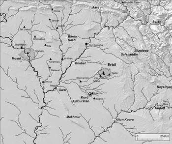
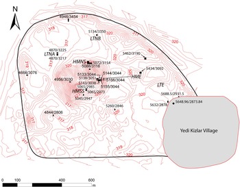
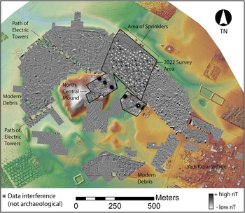
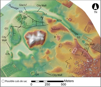
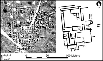
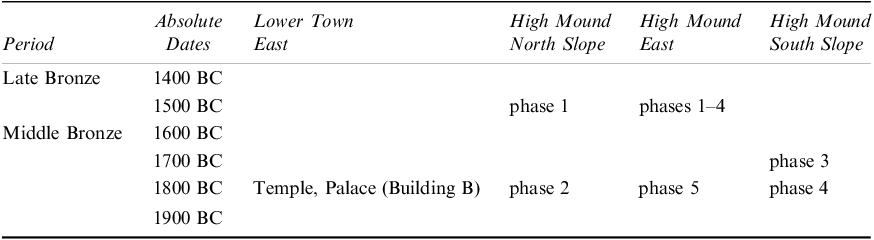
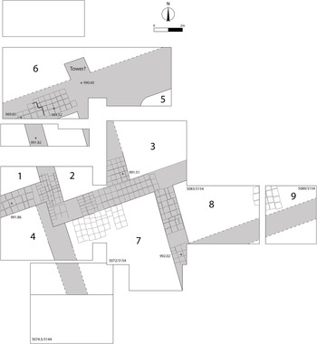
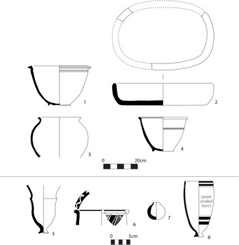

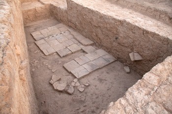
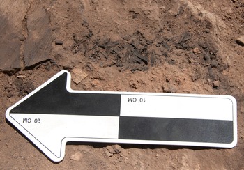

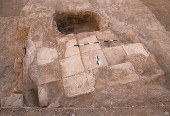
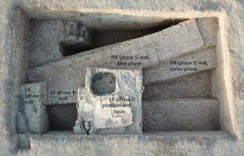
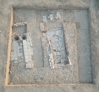
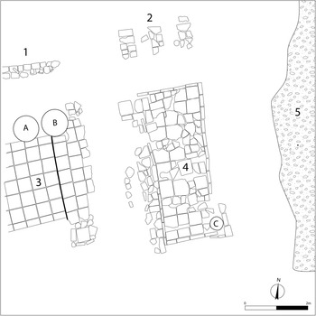
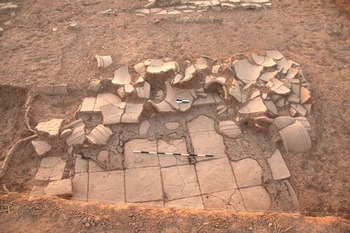
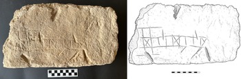
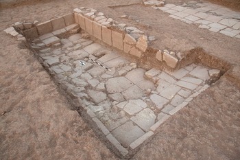
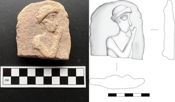
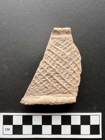
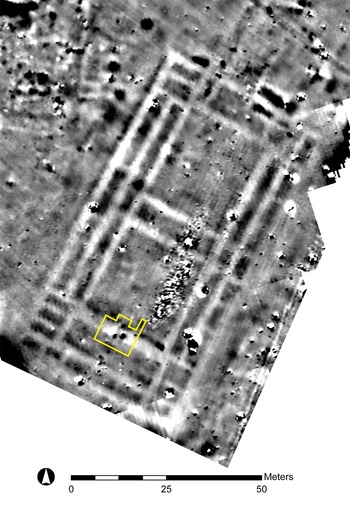
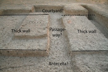
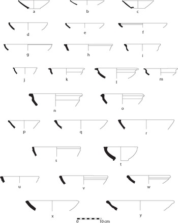
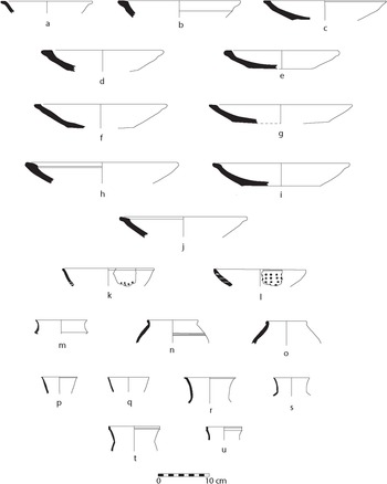
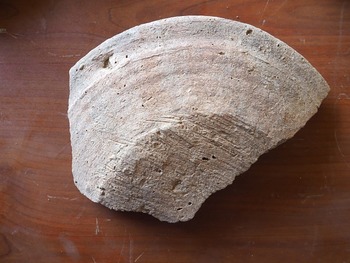
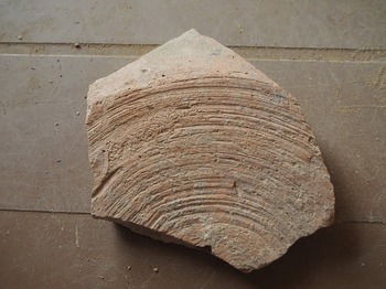
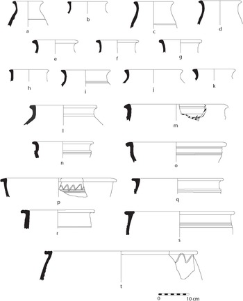
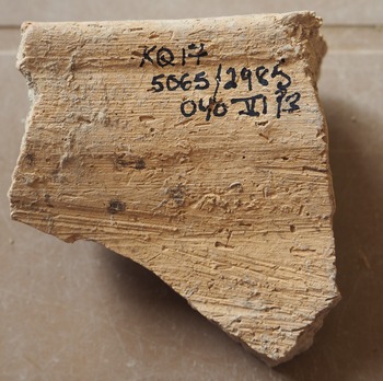
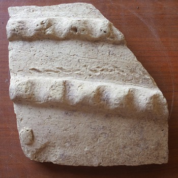
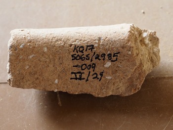
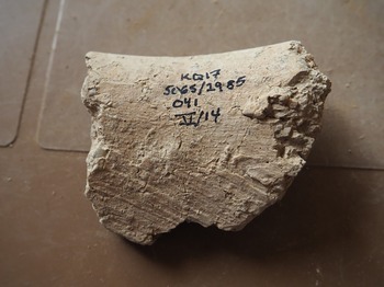

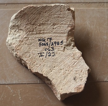

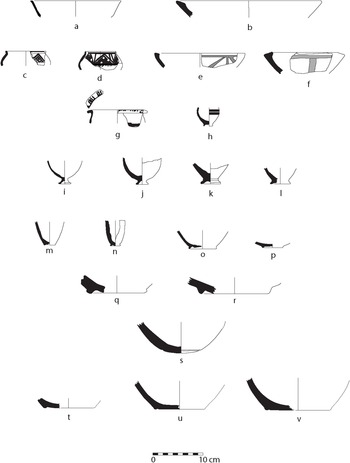
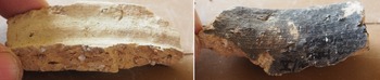
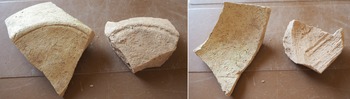


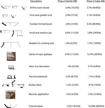
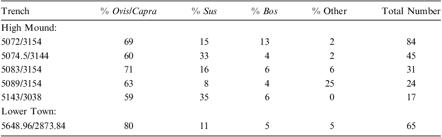
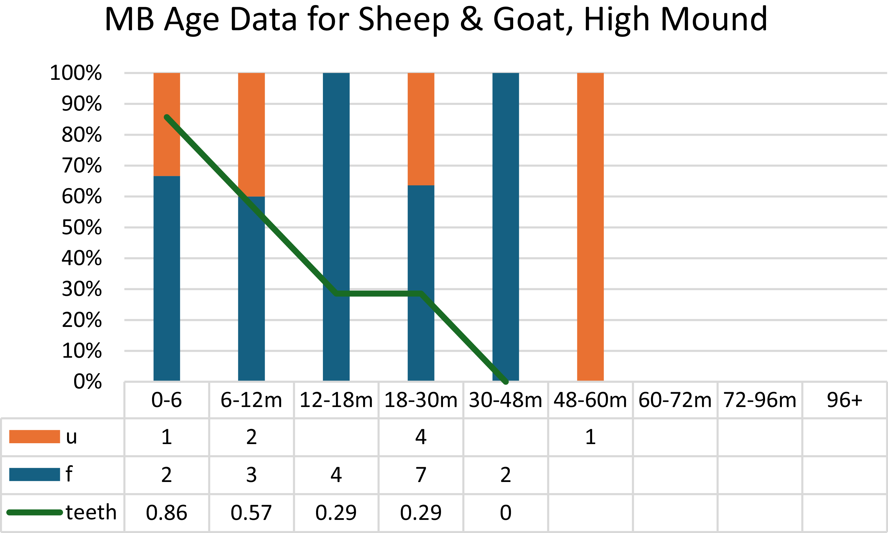
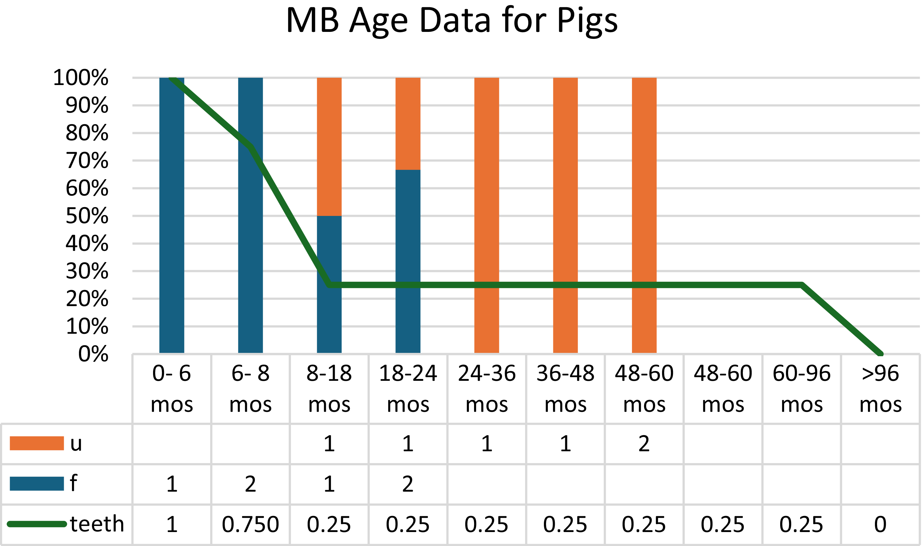
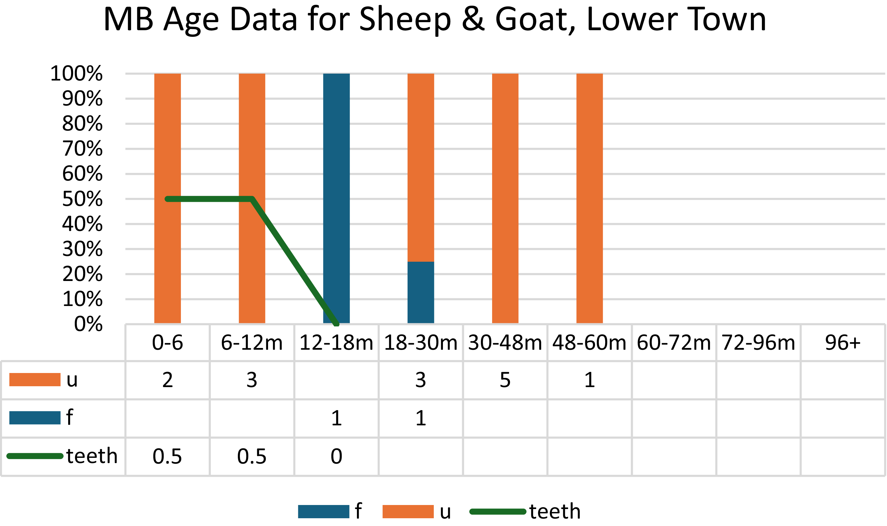

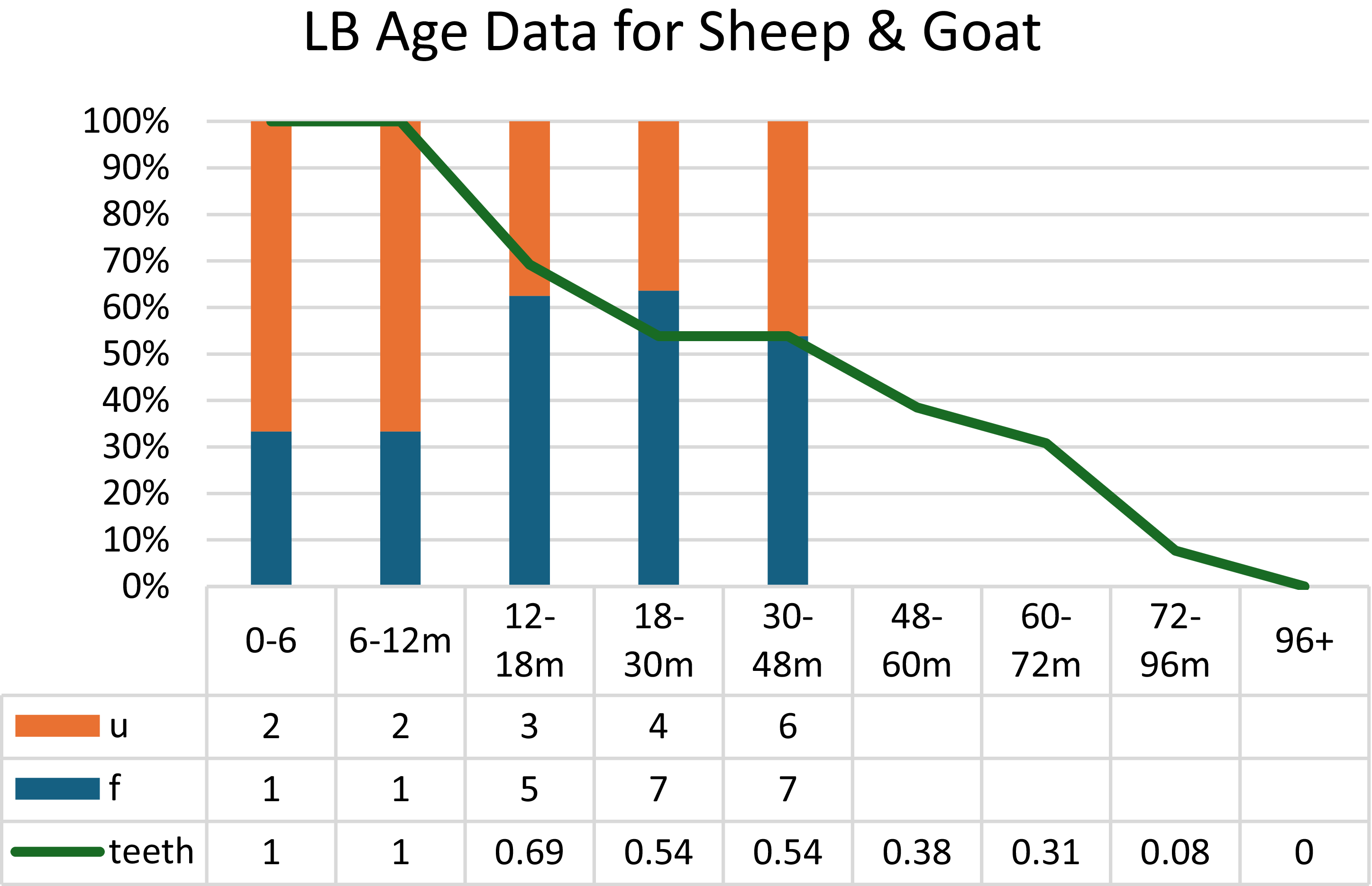
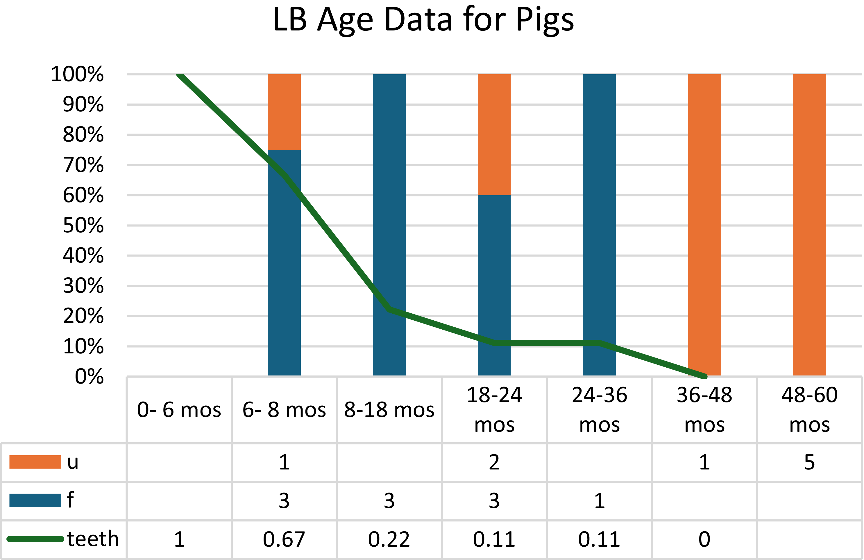
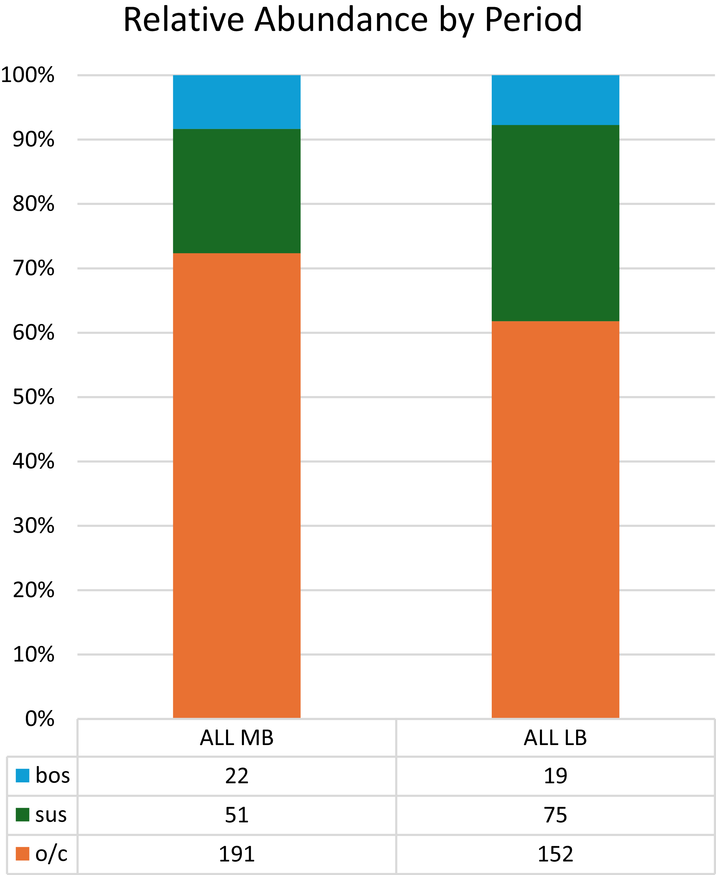
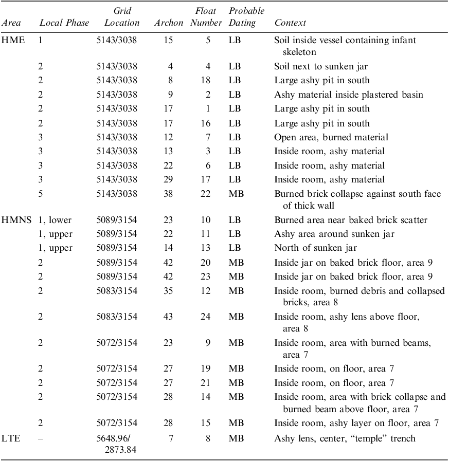
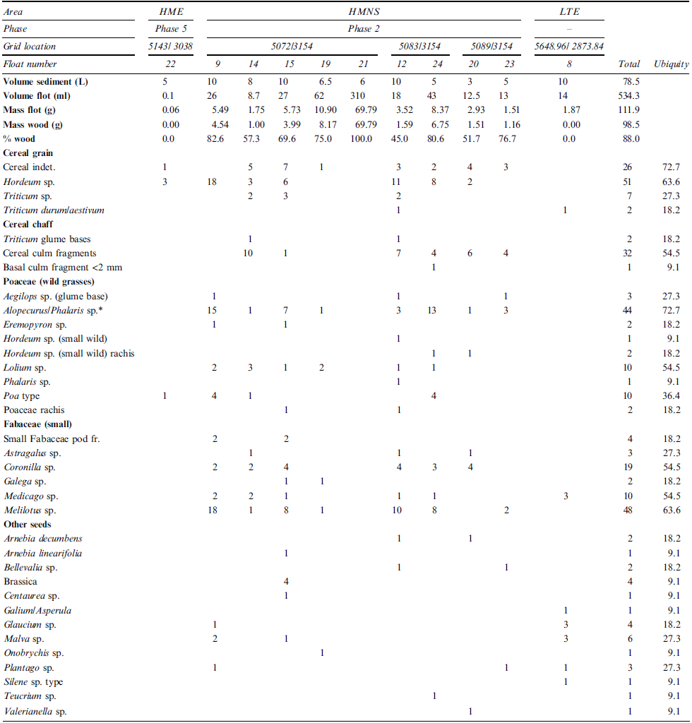
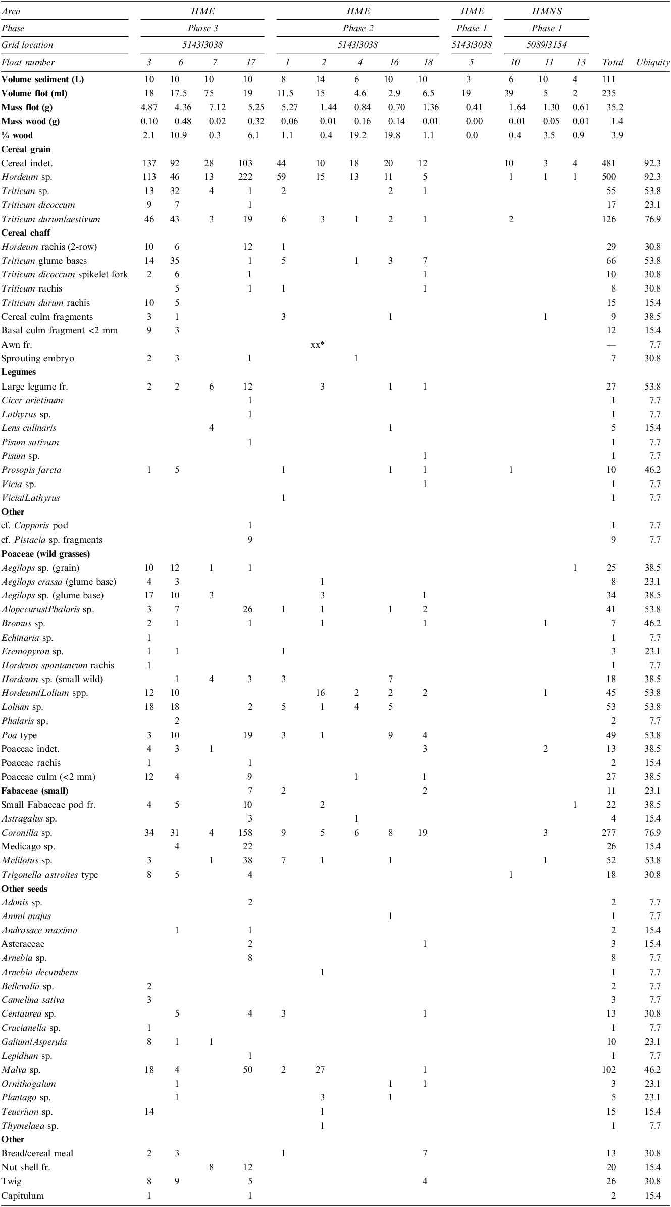

 Open access

