

Introduction
When Per Schei, geologist on the Second Norwegian Arctic Expedition in the Fram (1898-1902), reported on the results of his research in Ellesmere Island to the Royal Geographical Society (Reference ScheiSchei, 1903, p.64-65) he stated:
“After examining the unglaciated parts of the region with the view to discovering whether they may possibly have been subjected to glaciation at some earlier period, I arrived at results of a negative character. I nowhere observed roches moutonées, neither did I observe stria or scourings. Nay, further, I did not perceive any loose materials that could with any degree of likelihood be ascribed to the effects of glacier ice. Moreover, in several places I noticed marine terraces at a great height above the sea, running immediately in front of the existing glaciers, and in such a position that it is scarcely conceivable they could have been formed with the sea at its corresponding elevation if there had existed glaciation of even the same intensity as that which now obtains, to say nothing of a greater intensity. I believe I may venture to say, that in those regions the existing glaciation represents a maximum, such as has never been attained before …”
Schei”s conclusion with regard to the absence of evidence for more widespread glaciation is all the more remarkable because Fram’s first winter was spent in a small bay off Rice Strait, inside Pim Island at the northern end of Smith Sound (Figs 1 and 2), where glacially smoothed and scupltured Precambrian bedrock is present on all sides, and marginal drainage channels are prominent features of the landscape. In addition, perched boulders and far-travelled erratics of Palaeozoic and Proterozoic sedimentary rocks are abundant around Rice Strait, at the northern end of the region under discussion here.
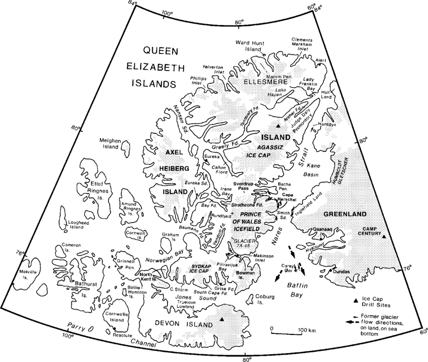
Queen Elizabeth Islands and northwestern Greenland, showing localities mentioned.
Landsat image of Smith Sound and southern Kane Basin. Arrows indicate flow direction of Smith Sound Ice Stream, as well as former directions of ice flow in bays and fiords tributary to Kane Basin. Note development of the North Water polynya on 4 April 1973 (image E-10255-18054, spectral band 7).

In contrast to Schei’s conclusions, T. C. Reference ChamberlinChamberlin (1895, p. 219) commented, after a visit to the Carey Islands (Carey Øer, Fig. 1), 225 km south of Rice Strait in northern Baffin Bay, with the Peary Auxiliary Expedition in 1894:
“They are very notably abraded by glacial action coming from the north. Striae are still preserved upon them at heights of 500 feet above the sea. There also occur upon them erratics of limestone, sandstone, shale and quartzite wholly unlike anything that occurs in the islands themselves. So far as I know, no rock of similar kind occurs in Greenland to the eastward. These erratics appear to have come from the region beyond Smiths sound to the north . . . It appears, therefore, that while a very notable southerly movement from the far north took place ... and reached at least to the Cary islands, there was no corresponding movement from the east.”
Chamberlin’s initial report was followed by a map which depicted the coalescence of ice sheets over Nares Strait and the southward flow of ice across the Carey Islands (Reference ChamberlinChamberlin, 1913).
In 1974 and 1976, the plateaus of all the major islands within the Carey Islands were examined. The general shape of the islands suggests overriding from the north-northwest, and striae are well preserved. Erratics, including shell fragments dredged from the sea bottom, are abundant on the plateaus (> 100 m a.s.l.). In places, because of the sharp contacts between diabase intrusives and the gneissic country rock on the plateau of Nordvestø (the largest island), the southward displacement of boulders of one rock type onto the other could be seen clearly. (Reference BlakeBlake, 1977a; cf. Reference Bendix-Almgreen, Fristrup and NicholsBendix-Almgreen and others, 1967). More recently, shaped bedrock landforms on the sea bottom have been described to the southwest, east and north-northwest of the Carey Islands (Reference Blake, Jackson and CurrieBlake and others, 1996). However, as with the Carey Islands themselves, whether or not glacier ice from Smith Sound extended this far south during the Last Glacial Maximum is still uncertain (cf. Reference Funder and HansenFunder and Hansen, 1996). In a recent review, Reference KellyKelly and others (1999) place the Late Weichselian ice margin well to the east, close to Dundas (Fig. 1), and to the north the limit is placed at the southern entrance to Smith Sound, albeit with a question mark.
The spectacular glacial sculpture in the environs of Cape Herschel and Pim Island was described briefly in a report written after the first field season (Reference BlakeBlake, 1977b), although no chronological data were then available. Following that visit, the succeeding 12 seasons, and 1998, were devoted to studying the glacial history of east-central Ellesmere Island and adjacent Greenland (e.g. Reference Blake, Robertsson, Ringberg, Miller and BrunnbergBlake, 1992a; Reference Blake, Robertsson, Ringberg, Miller and BrunnbergBlake and others, 1992). The purpose of the present paper is to illustrate some of the glacial features, and to discuss their significance in terms of the history of the last glaciation and the massive southward flow of wet-based ice through Smith Sound. This concentrated flow has been named the “Smith Sound Ice Stream” (Reference Blake, Robertsson, Ringberg, Miller and BrunnbergBlake, 1992b). Ice stream is used here as defined by Reference SwithinbankSwithinbank (1954, p. 185), “an outlet glacier of an inland ice sheet where there is no exposed rock to define its marginal limits” (cf. Reference MathewsMathews, 1991).
Setting
East-central Ellesmere Island is dominated by the Prince of Wales Icefield (Figs 1 and 2). The highest domes of the icefield rise above 2000 m; ice thicknesses along the crest are < 500 m for the most part, although a maximum of 800 m has been recorded (Reference KoernerKoerner, 1977). The icefield is characterized by the presence of many nunataks, and numerous independent, smaller ice caps also occur in the region. Outlet glaciers from the Prince of Wales Icefield drain eastward to the sea, and interspersed between these glaciers along Smith Sound is a narrow coastal fringe of ice-free land, East-central Ellesmere Island is dominated by the Prince of Wales Icefield (Figs 1 and 2). The highest domes of the icefield rise above 2000 m; ice thicknesses along the crest are < 500 m for the most part, although a maximum of 800 m has been recorded (Reference KoernerKoerner, 1977). The icefield is characterized by the presence of many nunataks, and numerous independent, smaller ice caps also occur in the region. Outlet glaciers from the Prince of Wales Icefield drain eastward to the sea, and interspersed between these glaciers along Smith Sound is a narrow coastal fringe of ice-free land, <East-central Ellesmere Island is dominated by the Prince of Wales Icefield (Figs 1 and 2). The highest domes of the icefield rise above 2000 m; ice thicknesses along the crest are < 500 m for the most part, although a maximum of 800 m has been recorded (Reference KoernerKoerner, 1977). The icefield is characterized by the presence of many nunataks, and numerous independent, smaller ice caps also occur in the region. Outlet glaciers from the Prince of Wales Icefield drain eastward to the sea, and interspersed between these glaciers along Smith Sound is a narrow coastal fringe of ice-free land, <5km wide, which is the subject of this paper. On the Greenland side of Nares Strait, outlet glaciers from the Greenland ice cap drain westward to the southern part of Smith Sound and south-westward to the northernmost part of Baffin Bay.
Within the ice-free coastal zone along Ellesmere Island, the Cape Herschel peninsula reaches 285 ma.s.l. and juts eastward into Smith Sound. Some 15 km north of Cape Herschel, Pim Island forms even more of an obstruction against overriding glacier ice, as it rises to 550 m a.s.l. and extends farther eastward at the northern entrance to Smith Sound. Both Cape Herschel and Pim Island are developed in Precambrian orthopyroxene granites, gneissic in places (Reference FrischFrisch, 1984). Similar rocks make up the opposing coast of Smith Sound (Reference Escher and PulvertaftEscher and Pulvertaft, 1995), but the upper slopes of the coastal hills in Inglefield Land are made up of varicoloured sandstones, shales and stromatolitic dolomites of the Smith Sound Group (Reference DawesDawes, 1997). Smith Sound itself is characterized by depths of over 500 m from Pim Island southward, whereas Kane Basin to the north is the shallowest part of Nares Strait, with much of its area < 200 m deep (Reference Pelletier and GarlandPelletier, 1966; Reference MonahanMonahan 1980).
Field Observations
Pim Island and the adjacent coast of Johan Peninsula (on Ellesmere Island proper), the Gape Herschel peninsula, and the outermost coast of Inglefield Land on the Greenland side of Smith Sound are all characterized by intense glacial scouring. Much of this area is bare rock; i.e. shaped rock bosses with clearly defined stoss and lee sides, together with striated and polished surfaces (Figs 3–6). In fact, Pim Island and Gape Herschel are themselves gigantic asymmetrically shaped rock bosses, more rounded on the north, with highest points nearer their southern coasts and with higher cliffs on their south (lee) sides. This landscape of areal scour (cf. Reference Sugden, Brown and WatersSugden, 1974, 1978) is dotted with small lakes and ponds, and on both Pim Island and Gape Herschel the ponds and lakes are concentrated within the southern half of the plateaus. Through-valleys, excavated along lines of structural weakness, are also present on both sides of the main trough (Smith Sound); for instance, Rice Strait separates Pim Island from northern Johan Peninsula of Ellesmere Island, and Elison Pass separates Cape Herschel from southern Johan Peninsula (Fig. 2).
View eastward across glacially sculptured bedrock on summit plateau of Pim Island, from highest point at 550 m a.s.l. Scale of3+m high rock boss in foreground is given by man below the plucked lee side (22 July 1977, GSC-203242).

Detail of striated and polished granite surface near highest point of Pim Island (550 m a.s.l.). Direction of ice flow is away from observer (toward the south). Note absence of differential weathering at contacts with the aplite dyke (22 July 1977, GSC-203243).

View south-eastward of glacially sculptured bedrock at ~160 m a.s.l. on peninsula leading to Cache Point, Inglefield Land (cf. Fig 2). The former direction of ice flow was NNE to SSW, roughly parallel with the coast of Smith Sound (11 June 1984, GSC-205033).

Sculptured red granite boss on Cape Herschel plateau at ~ 26.5m a.s.l. View southward, in direction of former ice flow, with Cape Isabella in the distance (22 July 1981, GSC-1998-035B).

To the west of Pim Island, higher on Johan Peninsula, the plateau remnant north of the largest outlet glacier, Leffert Glacier (Fig. 2), supports a small ice cap (summit elevation, 1220 m). Polished and sculptured outcrops are lacking adjacent to this ice cap, and the surface (840 m a.s.l.) is characterized by deep weathering (cf. Reference WattsWatts, 1981a, Reference Wattsb). A similar situation was encountered on the plateau (600 m a.s.l.) overlooking Alfred Newton Glacier, so clearly these plateaus lie outside the limit affected by the Smith Sound Ice Stream. They presumably supported a cover of cold-based ice, part of the Innuitian ice sheet. At Makinson Inlet, some 200 km to the south, the granite of 430 m high Bowman Island in mid-inlet is rounded and smoothed by intense glacial action, as well as by water under hydraulic pressure, as P forms are present (cf. Reference DahlDahl, 1965). However, the plateau to the north of the inlet is devoid of glacial features and instead has several incipient tors (Reference BlakeBlake, 1978), implying a cover of cold-based ice adjacent to a fiord, i.e. selective linear erosion. Adjacent to Bowman Island, water depths exceed 500 m (Reference SadlerSadler, 1973).
Till characteristics
The till in many places is a discontinuous veneer lying in topographically low spots on the polished and striated bedrock. Boulder-sized erratics are abundant, and a considerable number of these boulders are perched.
Sand: silt: clay ratios have been determined for samples from sites along both sides of Smith Sound, but particular attention has been paid to the Cape Herschel plateau (200— 285 m a.s.l.). The coarse (> 30 cm, minimum B axis) fraction of the till was studied in a 900 m2 area typical of the plateau surface by R. J. H. Richardson (Reference Richardson and BlakeRichardson and Blake, 1989). Of 221 clasts counted, the granitic bedrock accounted for 62%. These local clasts tended to be angular, reflecting the active glacial quarrying that has occurred. In a 4 m2 sub-area Richardson measured 458 clasts < 30 cm and > 3 cm, and in this group sedimentary clasts, such as dolomite (including stromatolites) and sandstone, accounted for 41 % of the total, whereas locally derived clasts accounted for only 31%. The higher percentage of sedimentary clasts in this finer fraction reflects the decrease in clast size which has occurred during long-distance transport, for the nearest known outcrops of sedimentary rocks (sandstones) are 35 km to the northwest. Rare erratics of marble derived from the basement to the northwest also occur; they must have travelled > 60 km to have reached Cape Herschel. The < 2 mm fraction of 46 surface-till grab samples on the Cape Herschel plateau has a mean sand: silt: clay ratio of 61:26:13. The uniform grain- size distribution of the fine matrix indicates thorough mixing and supports the idea of long transport. The high percentage of sand in the matrix is also consistent with comminution of all available rock types, especially soft sandstones (Reference ChristieChristie, 1983). Much of the clay fraction is reworked marine sediments, as attested to by the presence in the till, all over the Cape Herschel plateau, of thousands of marine pelecypod fragments, dredged from the sea bottom by glacier ice flowing into Smith Sound from the north and northwest (Fig. 1). Such erratic shell fragments are abundant over the plateau of Pim Island as well, up to > 500 m a.s.l.
Glacial sculpture and striae
The sculptured bedrock surfaces, knobs and bosses which are widespread on the plateau surfaces of the Cape Herschel peninsula, as well as on Pim Island and on Johan Peninsula along the west side of Rice Strait, are exceptionally well developed, as are the glacial features along the Greenland coast of Smith Sound (Figs 3-6). A special effort was made to locate striated sites around the edges of shallow, saucershaped depressions, in the centre of which a thin veneer of till (a few centimetres thick at most) was present. As it seems highly unlikely that any significant amount of till could have been moved out of such depressions since deglaciation, it was thought that the striae and polish represented accurately the excellence of preservation, even though these features had been exposed to the atmosphere, and hence had been subject to weathering, for some 8000 years.
Reference WattsWatts (1981a, p. 391) has commented on the nature of granite outcrops on Pim Island, and especially on Cape Herschel, as follows:
“The condition of the outcrop surfaces in this area immediately following glaciation to a large extent has determined the type of incipient weathering observed in the granite. Many features of glacial erosion on exposures remain intact with virtually no breakdown whatsoever. Preliminary breakdown of the outcrop surface has taken place primarily along joint systems and around original breaks in the glacially smoothed surface as, for example, around chattermarks ... Although glacial polishing appears to hinder direct surface disintegration, flaking has resulted from rock breakdown undercutting surface areas”.
As to micropitting, and the destruction of polished and striated surfaces, an experiment into atmospheric corrosivity was conducted at many sites in the Canadian Arctic Archipelago and in mainland Canada over a one-year period, from 1978-79 (Reference BieferBiefer, 1980). The corrosion rate of mild steel wire (on nylon bolts) at Cape Herschel was far higher than at most other sites in the Canadian Arctic Archipelago, a phenomenon tentatively attributed to localized concentrations of atmospheric chloride. Any exposed rock surfaces would have been subject to the same corrosive chemical effects. In the case of Cape Herschel, this is undoubtedly the result, in large part, of the proximity of the open water of the North Water polynya, allowing southerly winds to sweep moisture across the peninsula on a year- round basis, i.e. there is increased “time-of-wetness” (Reference BieferBiefer, 1980). That the rock surfaces are as intact as they are reflects the high degree of polish and provides an indication of the relatively short span of time they have been exposed (cf. Reference DykeDyke, 1978; Reference Hättestrand and StroevenHättestrand and Stroeven, 1996).
Age of Striated Surfaces
Several approaches have been tried to determine when the striated surfaces along Smith Sound were created, especially those above the limit of Holocene marine submergence. First, a program of coring high-level lakes (250-830 m a.s.l.) was initiated to determine if there were old, i.e. pre-Last Glacial Maximum, organic sediments preserved in any of the lake basins. This proved not to be the case (cf. Reference BlakeBlake, 1987), although pre-Holocene organic sediments have since been recovered from lakes on Baffin Island (cf. Reference Wolfe and HärtlingWolfe and Hartling, 1996). Alternatively, if such sediments are present, the hydraulic coring unit was unable to penetrate deep enough, or to push through till underlying Holocene organic sediments, to recover older datable material. Similarly, on top of the largest of the Carey Islands, basal peat was of early Holocene rather than interstadial age (Reference Brassard and BlakeBrassard and Blake, 1978).
A second approach has been to determine the 14C age of numerous marine shell fragments in till, as well as intact valves in pre-Holocene marine sediments in coastal sections. The finite ages obtained suggest the youngest shells may be of mid-Wisconsinan age (Reference Blake, Robertsson, Ringberg, Miller and BrunnbergBlake, 1992b). Because so little contamination with modern carbon is enough to make an infinitely old sample appear to be finite (e.g. Reference Olsson and BlakeOlsson and Blake, 1962; Reference PossnertPossnert, 1991; Reference ThomsenThomsen 1995), radiocarbon ages in the 25 000-50 000 year range on shells have been dismissed by many workers, or they have been treated as indicating minimum values. Yet because we also have several finite, pre-Holocene 14C ages on terrestrial materials beneath till adjacent to Glacier 7A-45 (Fig. 1) on the west side of the Prince of Wales Icefield (Reference Blake, Robertsson, Ringberg, Miller and BrunnbergBlake, 1992b), including five on individual sedge rhizomes and moss stems that range between ~20 and 35.5 kyr, it is reasonable to assume that ice-free conditions developed during a series of interstadials in the Smith Sound region as well. Such a scenario would match the data on interstadials from the Greenland ice sheet (Reference JohnsenJohnsen and others, 1992).
Third, whitish calcareous precipitates are present in places on the bedrock, and typically they are composed of both calcite and aragonite (ratios between 60:40 and 80:20). Two sites have been dated: a sample from the top surface of sculptured granite outcrops on the Cape Herschel plateau, at 220 m a.s.l., is 1070 ± 9014 Cyr old (GSC-4000; δ13C, +12.0‰). A second sample, collected at 420 m from the surface of gneissic bedrock on Bache Peninsula (Fig. 2), yielded a 14C age of 2010 ±50 BP (GSC-3692; δ13C, +8.7‰; both in Reference BlakeBlake, 1988). At first it was thought that these precipitates might have been deposited subglacially, at the time the Smith Sound Ice Stream was operative. However, their young age, unusual δ13C values, and the fact that the deposits are not themselves striated indicate that this is not the case (cf. Reference Lemmens, Lorrain and HarenLemmens and others, 1983). Nor can they be equated with the calcrete crusts described by Reference SwettSwett (1974) from East Greenland. They may correspond, in part, to the “white deposits” described by Reference Sharp, Tison and FierensSharp and others (1990) as translucent calcite deposits, pustular in form, which tend to occur in lee situations with respect to bedrock obstacles. Reference Sharp, Tison and FierensSharp and others (1990) also reported that the white deposits are characterized by heavy carbon isotope ratios, with peak values reaching +8‰. In eastern Ellesmere Island, if the age determinations are correct, these deposits may relate to the presence of thin, late-Holocene carapace ice caps. Such ice caps, which are common in the region today at higher elevations, may have formed in the late, colder part of the Holocene, but during the warming of the last two centuries (cf. Reference Koerner and FisherKoerner and Fisher, 1990; Reference Douglas, Smol and BlakeDouglas and others, 1994) these relatively thin, lowlevel ice masses have melted away. The fact that the calcareous precipitates are late Holocene, not interstadial, in age suggests that the fast-moving ice of the Smith Sound Ice Stream, and the tributary glaciers feeding into it, removed all older calcareous deposits in late-Wisconsinan time.
Another recent approach to the age problem has been to determine the time of surface exposure of glacially polished bedrock and erratics by measuring the amount of cosmogenic 36Cl accumulated in situ (Reference Zreda, England, Phillips and ElmoreZreda and others, 1994, Reference Zreda, Phillips and Elmore1995). The first set of mean ages, including some from Pim Island, indicates that ice sheets were coalescent over Nares Strait until 8 to 11 kyr. These ages correspond reasonably well to the earliest Holocene G results from organic lake-bottom sediments on Pim Island (Reference BlakeBlake, 1987, 1992a), as well as with the oldest 14G ages on Holocene marine shells throughout Nares Strait (Reference Kelly and BennikeKelly and Bennike, 1992; Reference EnglandEngland, 1998).
In addition, the general chronological pattern indicates the disappearance of massive amounts of glacier ice in northernmost Baffin Bay and the Nares Strait system following the Last Glacial Maximum. The oldest available ages (uncorrected) are close to 1100014 CyrBP on foraminifera above till-like sediment at the base of a core northeast of the Garey Islands (at 76°48.3' N, 71°51.5' W in 823 m of water; Reference Blake, Jackson and CurrieBlake and others, 1996). At the latitude of Gape Herschel (Fig. 1), 215 km to the north, the oldest shells indicate incursion of the sea at 900014 Cyr BP, but the heads of the three largest fiords, such asjokel Fiord (Fig. 2), 120–140 km to the west and northwest of Gape Herschel, did not become ice-free until 450014 Cyr BP. The massive loss of ice required to accommodate this amount of thinning and frontal recession fits well with the evidence of extreme summer melting in earliest Holocene time derived from a surface-to-bedrock core on the Agassiz Ice Cap, 270 km north of Cape Herschel (Fig. 1; Reference Koerner and FisherKoerner and Fisher, 1990).
Finally, the amount of Holocene emergence that has occurred at Cape Herschel (Reference Blake, Robertsson, Ringberg, Miller and BrunnbergBlake, 1992a, Reference Blake1993), amounting to > 110 m and perhaps as much as 130 m, is impressive indeed. The fact that this amount of emergence has occurred in the environs of Cape Herschel, despite the proximity and considerable load of tidal outlet glaciers and the Prince of Wales Icefield, can be explained most simply by the presence of much thicker ice at the Last Glacial Maximum.
Conclusions
The spectacular glacial sculpturing along the outer coasts of Smith Sound defines the strong north-to-south flow pattern of the former Smith Sound Ice Stream. This outlet enabled ice from the coalesced Innuitian and Greenland ice sheets to reach northernmost Baffin Bay. An ice stream that filled Smith Sound was necessary in order to force ice over Pim Island (550 m high, and with offshore water depths exceeding 500 m). Had there been more activity merely among the present-day outlet glaciers flowing into Kane Basin and Smith Sound, they would have flowed around, not over, obstacles such as Pim Island and Gape Herschel. The same is true in southern Inglefield Land, Greenland, where strong southerly flow occurred along the coast, and ice pushed inland over the coastal hills (Reference Blake, Robertsson, Ringberg, Miller and BrunnbergBlake and others, 1992). As discussed in Reference Blake, Robertsson, Ringberg, Miller and BrunnbergBlake (1992a), the thickness of ice in the Smith Sound Ice Stream at the latitude of Pim Island was at least 1100 m, as that amount is needed to fill the sound and reach the top of Pim Island, and a value of 1500 m would not seem unreasonable. Reference ReehReeh (1984) proposed an elevation of 1300 m for the saddle over Kane Basin between the Greenland ice sheet and the Innuitian ice sheet, assuming an ice margin (ice-sheet—ice-shelf transition) to the south at the 200 m depth contour. If the 600 m depth contour is used, the elevation of the saddle would be 1900 m. In the first case the ice margin would have been somewhere in Smith Sound, and in the latter case the Carey Islands would have been inundated and the ice margin would have been as far south as the shelf edge, south of 76° N. The first alternative does not seem to allow for the Smith Sound Ice Stream, whose existence would have prevented the formation of a re-entrant of open water from developing through Smith Sound (cf. Funder and Hansen 1996; Reference KellyKelly and others, 1999).
Determining the time when the sculpturing was accomplished is not simple, but progress has been made on several fronts. Cosmogenic dating to determine the length of time that a given striated surface or erratic boulder has been exposed at the surface is the technique that holds the greatest promise. At present it appears the following factors: 1) evidence from the ages of basal organic sediments in lake basins; 2) the apparent interstadial ages of some shells in till; 3) the Holocene age of calcareous precipitates on sculptured outcrops; 4) the first results of cosmogenic dating using 36Cl; 5) the general chronological pattern of glacier-ice thinning and recession; combined with 6) the Holocene emergence at Gape Herschel are concordant in indicating a significant cover of glacial ice over Kane Basin and Smith Sound at the last, or late-Wisconsinan (Weichselian), glacial maximum.
Acknowledgements
Generous logistical support in the field, 1977–89 and in 1998, was provided by the Polar Continental Shelf Project. The revisit in 1998 was made possible by J. P. Smol, Queen’s University, and M. S.V. Douglas, University of Toronto, with Natural Sciences and Engineering Research Council funding. Assistance was provided by many individuals, but special thanks go to R. J. H. Richardson, now with the Alberta Geological Survey, for help and discussions in the field and office for many years. R. P. Beukens, IsoTrace Laboratory, University of Toronto, processed most of the 14C ages referred to. Geological Survey of Ganada (GSG) staff provided help as follows: base camp facilities, 1977 (T. Frisch), shell mineralogy (A. C. Roberts), 14C dating (R. N. McNeely), grain-size analyses (P.J. Lindsay), photographs (R. G. Kelly), drafting (T. Barry), typing (S. Parnham) and manuscript review and discussion (D. A. Hodgson and R.M. Koerner). Journal reviewers, G. D. Clark, University of Sheffield, and an anonymous person, provided numerous helpful comments. This paper is GSC Contribution No. 1998059 and Cape Herschel Project Contribution No. 63.


