





Introduction
Farming systems have seen an increasing shift to conservation agriculture, involving the use of minimum tillage (e.g., knife point or disk seeding system) to sow the crop, to leave at least 30% of the soil surface undisturbed and covered with crop residue (Busari et al. Reference Busari, Kukal, Kaur, Bhatt and Dulazi2015; Smith et al. Reference Smith, Ryan, Menalled, Hatfield and Sauer2011). However, the occurrence of multiple, interacting soil constraints, such as soil acidity, compaction, topsoil water repellence, nutrient and organic matter stratification, or the proliferation of weeds, occasionally necessitates the use of strategic tillage techniques that involve a greater degree of mechanical soil disturbance (Azam et al. Reference Azam, Rahman, Wickramarachchi, de Sousa and Gricharm2023; Hall et al. Reference Hall, Davies, Bell and Edwards2020; Mia et al. Reference Mia, Azam, Nouraei and Borger2023). Soil inversion is one such technique that involves burying the topsoil to a depth of 15 to 40 cm while placing subsoil on the surface. While this tactic can alleviate soil constraints (Azam et al. Reference Azam, Rahman, Wickramarachchi, de Sousa and Gricharm2023; Davies et al. Reference Davies, Armstrong, Macdonald, Condon, Petersen, Pratley and Kirkegaard2019) it is also recommended as a weed management technique (Mohler Reference Mohler1993). Prior research has indicated that soil inversion can bury 50% to 99% of the weed seed and eliminate up to 99% of the emerged weeds (Colbach et al. Reference Colbach, Roger-Estrade, Chauvel and Caneill2000; Douglas and Peltzer Reference Douglas and Peltzer2004; Mohler et al. Reference Mohler, Frisch and McCulloch2006; Roger-Estrade et al. Reference Roger-Estrade, Colbach, Leterme, Richard and Caneill2001; Roper et al. Reference Roper, Davies, Blackwell, Hall, Bakker, Jongepier and Ward2015; Scanlan and Davies Reference Scanlan and Davies2019).
Soil inversion provides effective initial weed control by burying weed seeds, but a subsequent inversion event can return a portion of the buried seeds to the soil surface (Colbach et al. Reference Colbach, Roger-Estrade, Chauvel and Caneill2000; Mohler et al. Reference Mohler, Frisch and McCulloch2006). Renton and Flower (Reference Renton and Flower2015) proposed soil inversion every 4 to 8 yr for optimal weed control and management of resistant populations. However, this recommendation may not be useful if weed seeds at depth retain viability. Recent research on 24 agronomic weed species in Australia demonstrated that seeds of some grass species, including Australian fingergrass (Chloris truncata R. Br.), ripgut brome (Bromus diandrus Roth.), and hare barley [Hordeum murinum L. ssp. leporinum (Link) Arcang.], lose viability within 1 to 4 yr when buried at depths of 2 or 10 cm. By comparison, broadleaf weed species such as Afghan melon (Citrullus amarus Schrad.), southern threecornerjack (Emex australis Steinh.), and prostrate knotweed (Polygonum aviculare L.) will have a small proportion of the seedbank persist for more than 4 yr at 10 cm (Gill et al. Reference Gill, Borger and Chauhan2021). For all species, the seedbank degraded faster on the soil surface than when seeds were buried (Gill et al. Reference Gill, Borger and Chauhan2021). It is well established that burial inhibits weed seedling emergence, with the extent of inhibition influenced by seed morphology and soil properties (Benvenuti and Mazzoncini Reference Benvenuti and Mazzoncini2021; Mohler and Galford Reference Mohler and Galford1997). Burial also reduces exposure to granivores and physical degradation (Spafford Jacob et al. Reference Spafford Jacob, Minkey, Gallagher and Borger2006). Prior research has indicated that seeds buried at depth may retain viability for prolonged periods of up to 13 (Dawson and Bruns Reference Dawson and Bruns1975), 17 (Burnside et al. Reference Burnside, Wilson, Weisberg and Hubbard1996), or even 120 yr (Telewski and Zeevaart Reference Telewski and Zeevaart2002). The findings of Gill et al. (Reference Gill, Borger and Chauhan2021) suggests that soil inversion every 4 yr will excavate buried viable seeds. However, there is limited research on seedbank persistence when seeds are buried at depths greater than 10 to 20 cm.
Conservation agriculture is widely practiced in the Mediterranean, rainfed, winter annual grain cropping systems in Western Australia (WA) (Mia et al. Reference Mia, Azam, Nouraei and Borger2023). These systems employ no mechanical cultivation for seedbed preparation or weed control before seeding and minimal soil disturbance at crop sowing (Mia et al. Reference Mia, Azam, Nouraei and Borger2023). Therefore, a large proportion of the weed seeds shed at harvest remain at or near the soil surface (i.e., in the top 0 to 1 cm of soil) (Mia et al. Reference Mia, Azam, Nouraei and Borger2023). In these systems, it is necessary to occasionally practice strategic tillage operations like soil inversion to overcome the soil constraints induced by conservation agriculture (Davies et al. Reference Davies, Armstrong, Macdonald, Condon, Petersen, Pratley and Kirkegaard2019). Therefore, growers need to understand both the depth of weed seed burial from soil inversion and the duration of weed seed viability at depth in order to be aware of potential problems that may occur if viable seeds are returned to the surface via subsequent inversion events. To determine the length of time weed seeds remain viable after burial, this research surveyed sites across the Western Australian wheatbelt that had previously undergone soil inversion assessed through seedling emergence assays from soil samples. We hypothesized that grass weed seedlings would only emerge from soil samples taken from sites inverted within the past 4 yr, whereas broadleaf weed seedlings would also emerge from sites where inversion occurred more than 4 yr ago. These results will provide critical insight into the longevity of weed seeds buried at depth by soil inversion, enabling growers to better time and manage strategic tillage events for long-term, sustainable weed control in conservation agriculture systems.
Materials and Methods
Site Selection and Soil Sampling
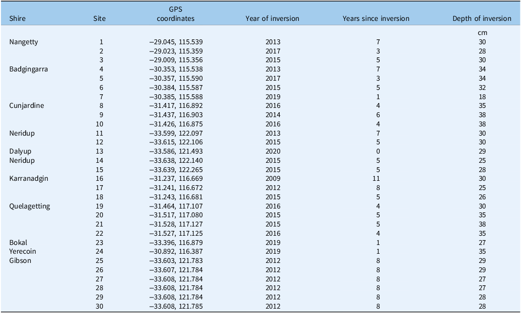
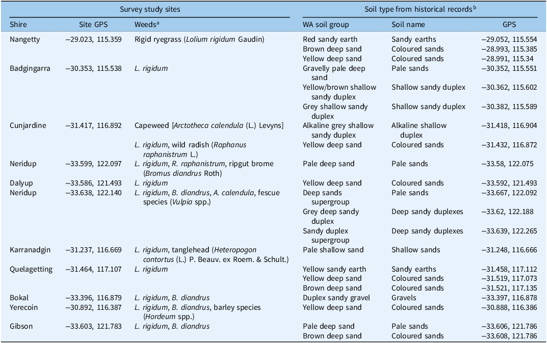
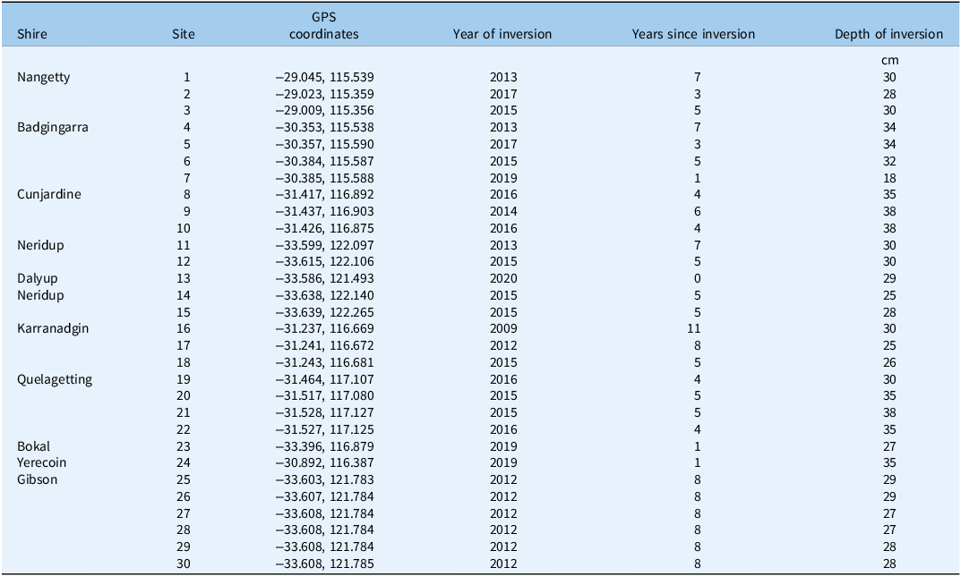
Eleven study sites were identified throughout the wheatbelt (i.e., broadscale grain-cropping and pasture region) (Table 1). Within each study site, multiple subsites were selected that had previously been subjected to a single soil inversion, resulting in a total of 30 sampled sites in the survey (Table 2; Figure 1). There were four criteria for selecting sites. First, sites were included if a single moldboard plowing event had been performed primarily for weed management, with no subsequent mechanical soil disturbance (i.e., no other form of deep tillage was implemented). Post-inversion, the only soil disturbance at each site occurred during annual crop sowing using a no-till seeding system, which would disturb the top 7 to 10 cm of soil (Mia et al. Reference Mia, Azam, Nouraei and Borger2023). Sites where inversion was performed primarily for soil amelioration (e.g., burying water-repellent layers or incorporating amendments) rather than for weed control were excluded, to ensure a buried weed seedbank was present for assessment. These potential sites were verified through grower interviews to gather knowledge on both the purpose of soil inversion and the presence of weed populations within the current cropping systems (Table 1). Second, sites were selected to have variable dates for the year of inversion. Because the research aimed to determine the seedbank persistence at depth, sites were selected where soil inversion was performed 1 to 11 yr before the survey. Third, sites were selected across northern, central, and southern areas of the WA wheatbelt to capture regional variability. Fourth, only sandy-textured sites were included. Seedbank persistence and seedling emergence can differ markedly between sandy and clay soils (Benvenuti and Mazzoncini Reference Benvenuti and Mazzoncini2021). In southwestern WA, sandy soils are more common than other soil types, and soil inversion is mainly used on these soils (Davies et al. Reference Davies, Armstrong, Macdonald, Condon, Petersen, Pratley and Kirkegaard2019; Hall et al. Reference Hall, Davies, Bell and Edwards2020; van Gool Reference van Gool2016). Given the small proportion of non-sandy soils, it would have been difficult to identify an equal number of sites with loam or clay soils that had been subject to inversion. Therefore, to avoid a soil type bias in the data, sites with non-sandy soils were excluded. Once potential sites were identified, the soil type was remotely assessed before visiting a property, using an existing database managed by the Department of Primary Industries and Regional Development (DPIRD) that contains 71,887 historical records of soil types in WA (Geospatial Data Hub 2023). The nearest available records in the database for each property were used to determine the soil type (Table 1).
The location of each of the 11 study sites, including shire name, GPS location (WGS84), and winter annual weeds on the property at the time of the survey.

a Some grass species were only identified at the genus level, as accurate identification at the species level is not possible until panicle emergence.
b Soil type from historical soil analysis records (Geospatial Data Hub 2023) is included for each site with soil type classified by Western Australian soil group (Galloway et al. Reference Galloway, van Gool, Stuart-Street, Griffin, Pathan and Schoknecht2024) or by its soil name (van Gool Reference van Gool2016), and GPS for the soil type record. GPS of the historical sample indicates how close the sample was to the study site, but can also be used to find the full historical sample record (containing further details of the soil type) within Geospatial Data Hub (2023).
Details of the 30 sampling sites selected for this study, including shire name for each property, site number, GPS location (WGS84), year in which the inversion was performed, interval between the inversion and the current study, and working depth for the inversion.
A map of the 30 soil sampling sites (red dots) in the Western Australian wheatbelt region (indicated by the diagonal yellow lines), with selected major towns included. The wheatbelt region was defined in a 2012 assessment of land use conducted by the Department of Primary Industries and Regional Development (DPIRD). Where multiple sites were overlaid, sufficient separation was applied to allow each site to be viewed (to allow readers to easily discern the number of sites in the northern, central, and southern wheatbelt). Exact GPS locations of each site are listed in Table 2. (Image courtesy of Elvyn Wise, DPIRD.).

Southern WA has a Mediterranean climate, and sampling occurred in the winter/spring annual cropping season. Therefore, only winter/spring annual weed species were present at the time of sampling; summer annual species were absent (Table 1). Further, herbicides would have been applied before and during the cropping season, minimizing in-field weed populations and potentially removing some species. Therefore, the weeds observed at sampling do not reflect the total potential weed seedbank and were only assessed to confirm the likelihood of a buried seedbank.
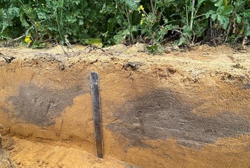
At each subsite on the farm, a record was made of location, year of inversion, depth of inversion (Table 2), reason for inversion, and current standing crops. Depth of inversion is influenced by operational parameters (implement type, number of plow boards, use of skimmers or trashboards, speed and depth of operation) (Saunders et al. Reference Saunders, Ucgul and Godwin2021; Ucgul et al. Reference Ucgul, Saunders and Fielke2017) and soil conditions (i.e., soil type, bulk density, moisture) (Mia et al. Reference Mia, Azam, Nouraei and Borger2023). However, as the inversion was a historical event, growers could not reliably recall these details. Therefore, to assess the depth of inversion at each site, a soil pit (1-m long by 0.5-m wide by 0.5-m deep) was excavated perpendicular to the direction of moldboard plowing. In the sandy soils of WA, the topsoil (A1 horizon) typically exhibits a darker color due to its higher organic matter content, whereas the underlying subsoil (B1 horizon) is generally lighter in color (i.e., pale gray or yellow; Table 1) (van Gool Reference van Gool2016). Because the soil had not been disturbed beyond seeding depth since the original soil inversion event, it was easy to visually assess where the topsoil was buried, allowing clear assessment of the depth to which the moldboard plow had operated (Figure 2). A ruler placed against the side of the pit could then be used to assess the depth of soil burial, based on the topsoil placement.
The site at Yerecoin, WA (i.e., site 24, Table 2), was subject to soil inversion in 2019 and assessed for working depth in 2020 by visual assessment of the placement of topsoil, i.e., the darker gray soil from the A1 topsoil horizon placed at depth within the yellow B1 subsoil horizon.

The soil pit was also used to confirm the spacing of the individual moldboard plow bodies (i.e., plow boards) and the corresponding placement of inverted topsoil layers. Once the inversion lines were determined, five random sampling points were selected along two adjacent lines of inverted soil. At each point, soil samples were collected using a 1-m-long coring tube (0.04-m internal diameter) to a total depth of 40 cm, separated into 10-cm increments (i.e., 0 to 10 cm, 10 to 20 cm, 20 to 30 cm, and 30 to 40 cm). Samples from the same depth across the five sampling points were bulked to form one composite sample per depth for each site and placed in a plastic bag. Soil samples were collected from 30 sites between June 2020 and October 2020. Note that this period is winter to early spring in WA, and seeds are shed during late spring/early summer for winter annual weeds, or summer/early autumn for summer annual weeds. No weed species shed seeds directly before June, and so all seeds were exposed to field-based afterripening before collection.
Soil type was not classified at each site, as an accurate assessment requires soil sampling to a greater depth than was performed in the current survey. The extent of the soil assessment was to confirm that the soil type was a sand (i.e., less than 10% clay and silt) and had a similar color to that predicted by historical samples from the historical soil sampling database (Galloway et al. Reference Galloway, van Gool, Stuart-Street, Griffin, Pathan and Schoknecht2024; Table 1). This was to confirm each site was a standard soil type for the property, as recorded in the database (Geospatial Data Hub 2023).
Weed Seedling Emergence
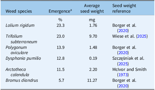
Soil samples from the field were initially air-dried (i.e., bags left open until the sample was dry) and then stored with the sample bag closed in a dark room refrigerated to 4 C to minimize emergence. After all samples were collected, weed emergence trays (15-cm long, 30-cm wide, and 8-cm deep) were filled with sterilized potting mix to within 2 cm of the top. The soil samples were then spread evenly over the potting mix to fill the top 2 cm of each tray. Soil samples were inspected for any seedlings that might have emerged between collection of the samples and placement in the trays, but very few were noted. The layer of sampled soil in the trays was 2 cm to ensure that all weed seeds would be placed at a depth of 0 to 2 cm. Previous studies report that while burial depth impacts emergence, a depth of 2 cm does not inhibit emergence (i.e., compared with emergence from the soil surface at a depth of 0 cm) for most species (Benvenuti and Mazzoncini Reference Benvenuti and Mazzoncini2021). It may reduce total emergence for species with very small seeds, but any potential impact of burial depth on emergence is lower for sandy soil than for heavier soil types (Benvenuti and Mazzoncini Reference Benvenuti and Mazzoncini2021). Seed weight of each species in the current study was recorded (Table 3) so that influence of seed size on emergence from a maximum depth of 2 cm could be considered in the discussion. Weed presence was evaluated through seedling emergence rather than by sifting the soil to extract weed seeds, as some species in WA have seeds that cannot be visually distinguished from sand, for example, buttongrass [Dactyloctenium radulans (R. Br.) P. Beauv.] (Asaduzzaman et al. Reference Asaduzzaman, Koetz and Rahman2019). For each depth sample from each site, soil was distributed over two trays, resulting in a total of 240 trays (30 sites by 4 depths by 2 trays). Trays were arranged in a randomized design in a screenhouse (i.e., an area screened from insects where trays were exposed to natural temperature and light fluctuations) at the DPIRD, Northam, WA (−31.6508, 116.6979). This site is in the center of the wheatbelt region from which the soil samples were collected. The natural temperature and light fluctuations at this site are suitable to trigger emergence of viable seeds from those species that might occur in the samples. Note that individual trays were not considered true replications, because the soil from each sampling point and depth was bulked before placement. Trays received automatic overhead irrigation as necessary to ensure soil remained moist for optimal emergence (generally twice daily, depending on the weather). As soil remained moist, surface crusting was not an issue. Trays were assessed weekly for a year, and emerged seedlings were counted and removed.
Emergence of weed species, as a percent of total emergence, and the reported average seed weight (from the literature) with corresponding reference.
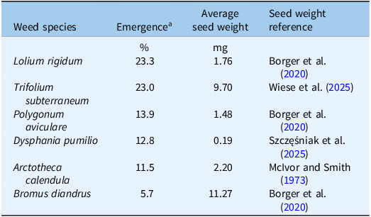
a Note that emergence as a percent does not equal 100%, as species with a density of ≤2% were excluded from the dataset.
Seedling emergence data for each site were summed across species to calculate total emergence and were expressed as the number of seedlings per 100,000 cm3 of soil, that is, the number of seedlings in a rectangular prism of 100 cm by 100 cm by 10 cm depth. This soil volume was used because samples were originally taken over depth increments of 10 cm, and seedling emergence from each depth increment was expressed as seedlings per square meter that would occur in the field (i.e., 1 m2 of soil to a depth of 10 cm). Data were then analyzed using a general ANOVA (Genstat 24th ed., https://vsni.co.uk/software/genstat/), using depth as the treatment and site as the replication (i.e., Genstat input code as TREATMENT Depth, BLOCK Site/Depth/Tray). A square-root transformation was performed to ensure a normal distribution of the residuals. Means are presented as both transformed and back-transformed data. Due to the abundance of zero values, we were unable to analyze the response of individual species.
To assess the relationship between number of years since inversion and total seedling emergence, we used an exponential regression model (Genstat 24th ed.). Seedling data from the 0- to 10-cm-depth increment were omitted from the analysis because the soil at this depth would have new seed added annually from existing weeds shedding onto the site. It was not the purpose of the analysis to compare total seed production from the existing weed population, but rather to determine how long buried seeds remained viable at depths greater than 10 cm. For the remaining depth increments (10 to 40 cm), the number of seedlings was averaged over sites with the same number of years since inversion was performed. The regression compared seedling number to the number of years since inversion.
Results and Discussion
Characteristics of the Sites
The surveyed sites were predominantly under cereal production at the time of soil sampling. Wheat (Triticum aestivum L.) (11 sites) and barley (Hordeum vulgare L.) (9 sites) were the most common crops, followed by lupins (Lupinus angustifolius L.) (5 sites), canola (Brassica napus L.) (4 sites), and pasture (1 site). The timing of soil inversion ranged from 2020 (0 yr ago) to 2009 (11 yr ago) (Table 2). The depth of inversion varied between 18 and 38 cm. However, only one site had a working depth of less than 20 cm (i.e., 18 cm). Of the remaining sites, 19 had a working depth between 21 to 30 cm, and 10 sites between 31 and 40 cm. While the primary motivation of soil inversion was weed control, a secondary motivation at 28 of the sites was burial of water-repellent surface soil. Only two sites, Badgingarra and Yerecoin, were inverted solely for weed control purposes.
Weed Emergence
In the field sites at the time of soil sampling, rigid ryegrass (Lolium rigidum Gaudin) was the most frequently observed weed species, followed by B. diandrus (Table 1). Within the trays of soil samples, a total of 16 species emerged, representing both summer and winter annual weeds. The most prevalent species were L. rigidum, subterranean clover (Trifolium subterraneum L.), P. aviculare, clammy goosefoot [Dysphania pumilio (R. Br.) Mosyakin & Clemants], capeweed [Arctotheca calendula (L.) Levyns], and B. diandrus (Table 3). However, species’ distribution was not uniform across sites. Lolium rigidum and T. subterraneum were widespread species, accounting for 23.3% and 23.0% of weed emergence from the trays, respectively. Lolium rigidum is the most common weed in Australian cropping systems (Ouzman et al. Reference Ouzman, Llewellyn and Azeem2025). This is mainly because it has been deliberately established as a pasture species, although its use in pasture is declining due to its detrimental impact in crop rotations and the reduction of the sheep (Ovis aries) industry in southern Australia (Bajwa et al. Reference Bajwa, Latif, Borger, Iqbal, Asaduzzaman, Wu and Walsh2021). Trifolium subterraneum cultivars are also pasture species, and have been bred for long-term dormancy to increase persistence in permanent and ley pasture within cropping rotations (Nichols et al. Reference Nichols, Loi, Nutt, Evans, Craig, Pengelly, Dear, Lloyd, Revell, Nair, Ewing, Howieson, Auricht, Howie and Sandral2007). By comparison, the next most common species, P. aviculare and D. pumilio, only accounted for 13.9% and 12.8% of emergence, respectively. Other species, including stinkgrass [Eragrostis cilianensis (All.) Vign. ex Janchen], southern crabgrass [Digitaria ciliaris (Retz.) Koeler or Digitaria sanguinalis (L.) Scop.], C. amarus, Siberian pygmyweed [Crassula sieberiana (Schult.) Druce], redstem stork’s bill [Erodium cicutarium (L.) L’Hér. ex Aiton], nightshade species (Solanum spp.), Hordeum spp., puncturevine (Tribulus terrestris L.), lanceleaf sage (Salvia reflexa Hornem.), and bird’s-foot species (Ornithopus spp.) were recorded at very low densities (i.e., less than 2% of total weed emergence) and only at one or two sites and were, therefore, removed from the dataset before further analysis.
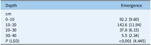
Weed emergence varied with soil sampling depth. Mean weed emergence was highest in samples collected from 10- to 20-cm depth, followed by those from 0- to 10-cm depth (Table 4). Significantly lower emergence occurred in samples from depths greater than 20 cm. A large proportion of viable weed seeds at 0 to 10 cm was expected, as fresh seeds are shed annually onto the soil surface and incorporated to a depth of 10 cm during the crop sowing operation (Mia et al. Reference Mia, Azam, Nouraei and Borger2023). It was not the purpose of this research to assess crop rotations or pesticide regimes to determine seedbank replenishment or the weed population dynamics. Sites were selected to ensure that no disturbance beyond crop sowing to 10-cm depth occurred following the inversion, to ensure that the weed population dynamics and topsoil seedbank replenishment in the 1 to 11 yr since the inversion event did not affect the number of viable seeds at depths beyond 10 cm. Borger et al. (Reference Borger, Mwenda, Collins, Davies, Peerzada and van Burgel2024) found that a soil inversion buried the majority of L. rigidum or B. diandrus seeds at a depth of 10 to 20 cm, with no seeds placed beyond 20 cm. This contrasts with the current findings, where most sites had some seedlings emerge in those samples from depths greater than 20 cm. Fewer seedlings emerged from samples taken at 30 to 40 cm than at 20 to 30 cm, likely because only 10 sites had inversion depths beyond 30 cm.
Average weed emergence from soil at 10-cm intervals, over a depth of 0 to 40 cm (with seedling emergence from each 10-cm depth converted to seedlings m−2 in the soil at the field collection sites). a
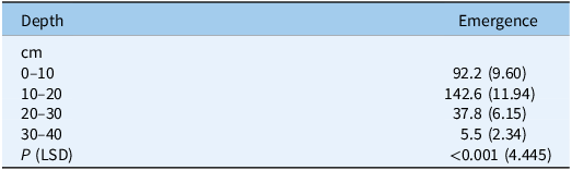
a Data were subject to a square-root transformation, and means are presented as back-transformed data, with the transformed values in parentheses. The least significant difference (LSD) should be applied to the transformed data.
Previous studies indicate that soil inversion can place weed seeds predominantly near the furrow base (i.e., at the maximum depth of working), concentrated in the center of the plowed layer, or distributed throughout the disturbed zone, depending on initial position of seeds in the soil profile, soil type, speed of operation, plow characteristics, and soil throw (Roger-Estrade et al. Reference Roger-Estrade, Colbach, Leterme, Richard and Caneill2001). Aside from assessing the soil type as sand, other factors influencing seed placement during a soil inversion operation were not investigated in this study. However, sites were selected that had not been exposed to disturbance via soil amelioration before or after the recorded soil inversion event, so the seeds were at or near the soil surface at the time of inversion. Roger-Estrade et al. (Reference Roger-Estrade, Colbach, Leterme, Richard and Caneill2001) used a model to highlight that where the initial seedbank has 100% of seeds on the soil surface, an inversion without a skim coulter should evenly distribute the seedbank over the entire working depth. Soil inversion with a skim coulter should result in the largest proportion of the seedbank being placed at the base of the furrow. However, their model was field tested in France, in soil types that included an Orthic luvisol and Eutric cambisol (22% and 39% clay, respectively), with soil type from the World Reference Base for Soil Resources (IUSS Working Group WRB 2015). Likewise, Swanton et al. (Reference Swanton, Shrestha, Knezavic, Roy and Ball-Coelho2000) found that moldboard plowing in a sandy soil (Brunisolic luvisol, 7.5% clay and 85% sand) in Canada placed 71% of weed seeds at the base of the furrow (i.e., 10 to 15 cm, which was the maximum working depth). This was compared to no-till with 90% of the seedbank at 0 to 5 cm, or chisel plowing with 66% of seeds at 5 to 10 cm (Swanton et al. Reference Swanton, Shrestha, Knezavic, Roy and Ball-Coelho2000). Scanlan and Davies (Reference Scanlan and Davies2019) highlighted that during inversion of a sandy soil (Cambic arenosol, 7% clay and 93% sand) in WA, 62% of topsoil (0 to 10 cm) was placed at a depth of 10 to 20 cm, with only 21% of topsoil placed at depths of 20 to 30 cm. The maximum working depth in the study was 30 cm, so the weed seeds were being placed in the center of the plowed layer.
Internationally, most agricultural soil types are loams or heavier textures, in contrast to the sandy soils common to southern Australia (Spokas et al. Reference Spokas, Forcella, Archer and Reicosky2007; van Gool Reference van Gool2016). As a result, most data on seed burial have been generated from heavier soil types, but soil type is known to have a significant impact on seed burial (Roger-Estrade et al. Reference Roger-Estrade, Colbach, Leterme, Richard and Caneill2001; Spokas et al. Reference Spokas, Forcella, Archer and Reicosky2007; Swanton et al. Reference Swanton, Shrestha, Knezavic, Roy and Ball-Coelho2000). Overall, the current research supports the previous findings of Scanlan and Davies (Reference Scanlan and Davies2019) that in sandy soils, a substantial portion of surface weed seeds are not buried to the full working depth during a soil inversion.
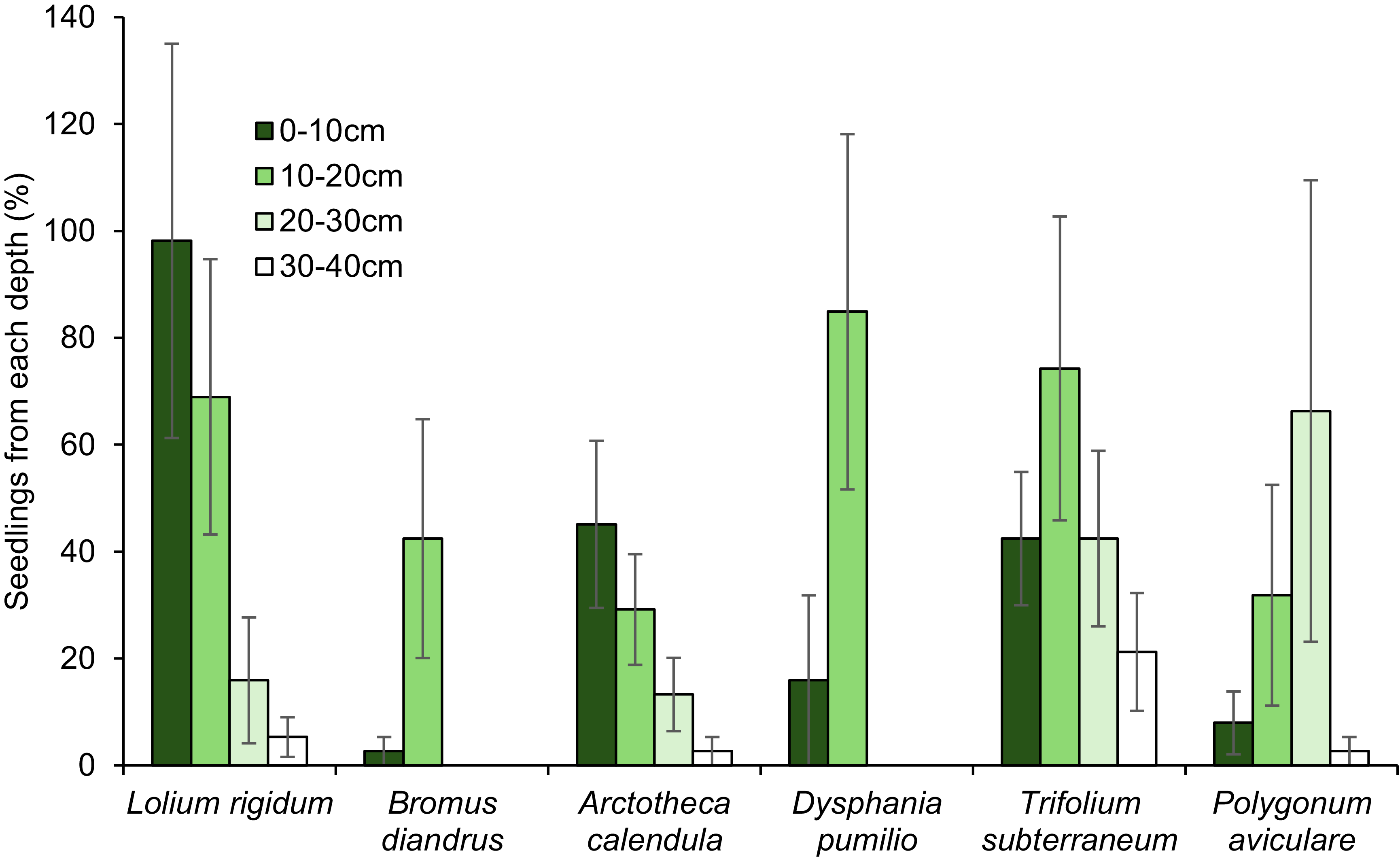
Of the six most common species, B. diandrus and D. pumilio had 0 seedlings emerge from samples taken beyond a depth of 20 cm, despite both species being present at sites where the depth of inversion exceeded 20 cm. By comparison, T. subterraneum and P. aviculare had 69.0% and 63.7% of the total seedling emergence, respectively, from samples collected below 20 cm (Figure 3). Of the other species, L. rigidum and A. calendula had 21.2% and 15.9% of seedlings, respectively, emerging from samples taken at depths greater than 20 cm. These findings align with previous reports indicating both T. subterraneum and P. aviculare exhibit long-term dormancy (Costea and Tardif Reference Costea and Tardif2005; Nichols et al. Reference Nichols, Loi, Nutt, Evans, Craig, Pengelly, Dear, Lloyd, Revell, Nair, Ewing, Howieson, Auricht, Howie and Sandral2007).
Percent emergence of the six most common weed species over all sites, from depths of 0 to 40 cm. Vertical bars indicate the SE of 30 samples.

Seedling Emergence and the Number of Years since Soil Inversion
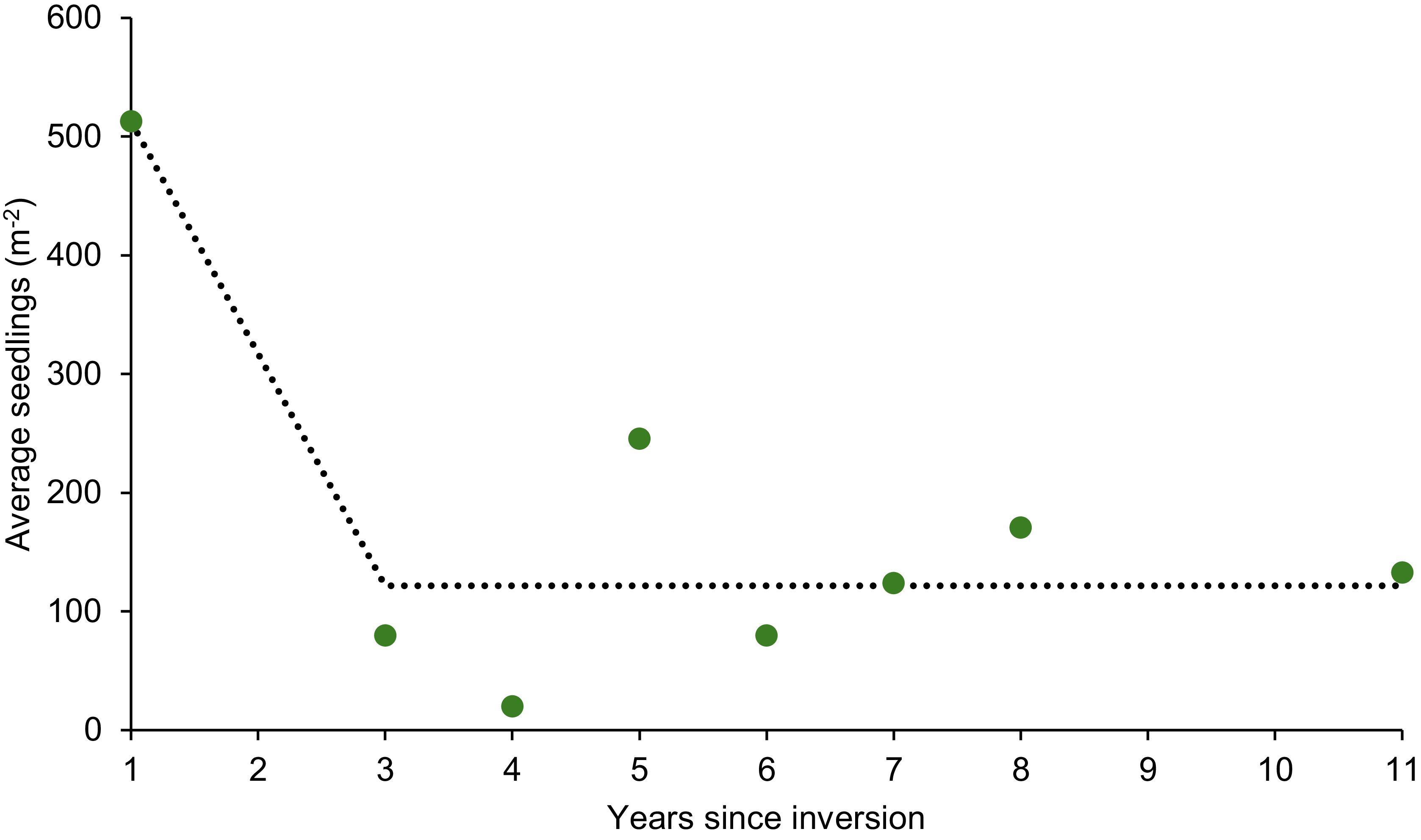
There was a significant exponential relationship between seedling number and the number of years since the soil inversion event (Figure 4). Seedling emergence, averaged across the 10- to 20-cm, 20- to 30-cm and 30- to 40-cm soil depths, was highest (513 plants m−2) at sites where soil inversion had occurred within the previous year. By comparison, sites where inversion occurred 3 to 11 yr before the sampling had lower seedling densities, ranging from 19.9 to 245.4 plants m−2. After the first year, there was no significant decline in the number of seedlings emerging from samples. In the sites where inversion occurred 3 to 8 yr before the survey, there were multiple species emerging. At the site where inversion had occurred 11 yr before the survey, P. aviculare was the only species to emerge in the current study. Prior studies have suggested that the P. aviculare seedbank requires 9 yr for a 95% decline in loam soils or up to 20 yr to decline in a clay soil, although a site was recorded where viable seeds were retrieved after 60 yr (Costea and Tardif Reference Costea and Tardif2005). In general, seeds of most weed species have short-term seedbanks (1 to 3 yr) when located on or near the soil surface, due to higher exposure to germination triggers, microbial degradation, or seed predation (Chauhan et al. Reference Chauhan, Gill and Preston2006; Mohler and Galford Reference Mohler and Galford1997; Spafford Jacob et al. Reference Spafford Jacob, Minkey, Gallagher and Borger2006). However, burial at depth substantially increases seedbank persistence (Benvenuti and Mazzoncini Reference Benvenuti and Mazzoncini2021; Costea and Tardif Reference Costea and Tardif2005; Mia et al. Reference Mia, Azam, Nouraei and Borger2023).
The emergence of weed seedlings averaged over depth increments of 10–20 cm, 20–30 cm, and 30–40 cm and averaged over sites with a similar number of years since inversion (1 to 11 yr), regressed against the number of years since inversion. The dotted line indicates the regression equation y = 121.6 + 755,212 × 0.00051 x (R2: 73.2, P: 0.016).

Bromus diandrus was the only species in the current study for which seedlings emerged exclusively from sites where the soil inversion event had occurred within the previous 2 yr, and not from older sites. However, B. diandrus seeds were only found at depths of 0 to 10 cm or 10 to 20 cm. Previous research has shown that B. diandrus seedlings can establish from depths up to 20 cm, although the resulting seedlings may have reduced vigor (Mia et al. Reference Mia, Azam, Nouraei and Borger2023). Therefore, if B. diandrus seeds are not buried at a depth greater than 20 cm, soil inversion is unlikely to prevent emergence or extend seedbank persistence beyond 3 to 4 yr typically observed for this species in agronomic systems (Kleemann and Gill Reference Kleemann and Gill2006). Benvenuti and Mazzoncini (Reference Benvenuti and Mazzoncini2021) noted that the emergence of species with larger seeds was less inhibited by burial. Among the six dominant species recorded in the current study, B. diandrus had the largest seed, consistent with its reduced emergence inhibition (11.27 mg; Table 3). Unlike B. diandrus, T. subterranean had the second-largest seed (9.7 mg) and was persistent at depth. However, this species has been deliberately selected for short- and long-term seedbank persistence by historical breeding programs prior to T. subterranean cultivars being sown in wheatbelt pasture systems (Nichols et al. Reference Nichols, Loi, Nutt, Evans, Craig, Pengelly, Dear, Lloyd, Revell, Nair, Ewing, Howieson, Auricht, Howie and Sandral2007). All other species had a seed weight of 2 mg or less and would be expected to have emergence inhibited by burial.
In the current study, the burial depth in the seedling emergence assay may impact emergence of some species. Benvenuti and Mazzoncini (Reference Benvenuti and Mazzoncini2021) found that Canadian horseweed [Erigeron canadensis L.; syn.: Conyza canadensis (L.) Cronquist] had 50% emergence inhibition in sand at a depth of 2.4 cm. However, the other 11 weed species in their study needed depths of 4.2 to 6.6 cm to experience 50% emergence inhibition. Erigeron canadensis also had the smallest seed size, at 0.00007 mg per seed (1,000-seed weight of 0.07 mg), while other species had seed weights of 0.00048 to 0.00923 mg. Therefore, all species in the research by Benvenuti and Mazzoncini (Reference Benvenuti and Mazzoncini2021) had smaller seeds than the six most common species in the current study. By comparison, the species in this study with the smallest seed, D. pumilio, had a seed weight of 0.19 mg (Table 3). It is possible that some of those species removed from the dataset due to low emergence had seeds small enough to suffer some inhibition of germination at depth. For example, E. cilianensis has an average seed weight of 0.0000903 mg in southern WA (D Nicholson, DPIRD, personal communication, 2025). Like E. canadensis, E. cilianensis seeds at 2 cm may have suffered inhibition to germination, but in the current study, most seed would be at a shallower depth than 2 cm (i.e., buried between 0 to 2 cm within the 2-cm layer of soil). Therefore, this method is unlikely to have substantially inhibited the emergence of small-seeded species. There was also a longer storage time for some samples than others (up to 4 mo over the survey period). Air-drying the soil before storage should have minimized emergence, but storage at a cool temperature in the dark may have induced dormancy, which has been documented for L. rigidum (Goggin et al. Reference Goggin, Powles and Steadman2012). However, the emergence assay was likely conducted over a sufficient period to allow seeds to cycle out of dormancy.
Soil inversion has been highlighted as a weed management technique (Mia et al. Reference Mia, Azam, Nouraei and Borger2023; Renton and Flower Reference Renton and Flower2015). However, the current research confirms that, once buried, seeds of multiple grass and broadleaf species could retain viability for at least 8 yr. While multiple studies have highlighted the long-term persistence of P. aviculare or T. subterranean, grass species such as L. rigidum have a short-lived seedbank (3 to 4 yr) when seeds are at or near the soil surface (Bajwa et al. Reference Bajwa, Latif, Borger, Iqbal, Asaduzzaman, Wu and Walsh2021; Costea and Tardif Reference Costea and Tardif2005; Nichols et al. Reference Nichols, Loi, Nutt, Evans, Craig, Pengelly, Dear, Lloyd, Revell, Nair, Ewing, Howieson, Auricht, Howie and Sandral2007). Because L. rigidum seedlings could emerge in the current study after 8 yr of burial, these results reinforce that burial at depths greater than 10 cm prolongs seed longevity. The exception was B. diandrus, as this larger-seeded weed species could emerge and reinfest the cropping system in the 1 to 2 yr following burial (Borger et al. Reference Borger, Mwenda, Collins, Davies, Peerzada and van Burgel2024). Other authors have suggested that applying soil inversion every 4 to 8 yr could slow the development of herbicide resistance (Renton and Flower Reference Renton and Flower2015) by redistributing the seedbank. However, the current results suggest that some seeds buried at depth would retain viability after this time span, and seeds at depths of 10 to 20 cm may be redistributed to the surface layers by subsequent strategic tillage events (Roger-Estrade et al. Reference Roger-Estrade, Colbach, Leterme, Richard and Caneill2001; Scanlan and Davies Reference Scanlan and Davies2019). Further research is required to determine what proportion of the seedbank remains viable at depth, in comparison to total seed on the soil surface and surface seedbank replenishment. Research is also required to determine how much seed might be returned to the surface from future strategic tillage operations. However, growers should consider the movement and potential return of the buried seedbank if they are utilizing soil inversion to delay the development of or manage herbicide-resistant weeds.
Acknowledgments
The authors are grateful to the growers who allowed soil sampling on their properties, Dave Nicholson and Nerys Wilkins (DPIRD) for technical assistance, Andrew van Burgel (DPIRD) for statistical support, and Geoff Anderson and Arslan Peerzada for reviewing the paper.
Funding
The research was funded by the DPIRD “Royalties for Regions’ Science Partnership Project.”
Competing interests
The authors declare no conflicts of interest.


 Open access

