

Introduction
The garrison at Bu Njem was founded in AD 201 and abandoned between AD 259–263 (Rebuffat Reference Rebuffat1989, 156). The site lies 192 km east of a larger military base at Gheriat-el-Garbia (Reddé Reference Reddé and Guédon2018, 151). Bu Njem's extraordinary preservation and its ostraca (Marichal Reference Marichal1992) have earned the site an important role in the archaeology of Roman frontiers. Epigraphic evidence shows the fort was built by a vexillatio of Legio III Augusta (Rebuffat Reference Rebuffat1989, 155), whose mother base was located at over 1,000 km away at Lambaesis, in modern day Algeria. In AD 238 Legio III Augusta was dissolved as punishment for its participation in the revolt of Gordian I. Bu Njem was subsequently occupied by a detachment of auxiliaries with a decurion in charge (Rebuffat Reference Rebuffat1989, 155). The legion is attested epigraphically at Bu Njem again soon after its reconstitution in AD 253 and its detachment remained at Bu Njem until the site's abandonment (Rebuffat Reference Rebuffat1989, 156).
Thanks to desert conditions, the preservation of the site at the time of its excavation proved extraordinary on the scale of the entirety of the Roman empire. In places the archaeology stood up to the ceiling level. The site was excavated by a mission led by Rebuffat between 1967 and 1980 with the objective of establishing the fort layout and tracing the extent of the extramural settlement (Rebuffat Reference Rebuffat1989, 157). The excavation uncovered the principia building, the commanding officer's house, granaries, ramparts, bath house, parts of the barracks and a small number of features in the extramural settlement (Rebuffat Reference Rebuffat1989). Revealed during several excavation campaigns was a dossier of 146 pieces of correspondence written on sherds of pottery. This provides a rare insight into the operations of a frontier post. The archive presents a partial and somewhat haphazard selection of documents. Yet, in terms of its size and content, the dossier can only be compared to a handful of other military archives from across the entire Roman empire. The Bu Njem ostraca include information on daily activities of soldiers, assignments within and outside the camp, letters revealing information regarding circulation of personnel, civilians and goods, names of soldiers indicating their origin, and material to study Punic influences on the Latin used in the region (Adams Reference Adams1999; Cooley Reference Cooley2012; Marichal Reference Marichal1979, Reference Marichal1992). Subsequent research on Bu Njem has largely focused on studying the organisation of the fort, or, in the context of the ostraca and inscriptions, on the linguistic and literary perspectives on the texts (Adams Reference Adams1999; Rebuffat Reference Rebuffat1995). This results in an opportunity to integrate the textual data with archaeological spatial data and to incorporate the extramural settlement into the interpretation of the fort. Work on the linguistic aspects of the texts has brought to the fore the multicultural and multilingual identities of the inhabitants of Bu Njem (Cooley Reference Cooley2012, 274–284; Rebuffat Reference Rebuffat1975b). In terms of archaeological evidence, existing work opens the opportunity to study the garrison as an extended military community in its interconnected social, cultural, and economic settings. Since the completion of the excavations at Bu Njem, there have been significant advances in research on the Garamantes, trade in the Sahara and the understanding of socio-economic relations on North African frontiers. Through building on the achievements of previous work and revisiting archival material it is possible to further the understanding of the garrison, its town and of its people. Equally, the rich case study of Bu Njem is of value to advancing work on the wider regional picture (Mattingly Reference Mattingly1995).
The primary sources of data discussed here consist of yearly excavation reports and research notes published in Libya Antiqua (Rebuffat Reference Rebuffat1967, Reference Rebuffat1970a, Reference Rebuffat1970b, Reference Rebuffat1975a, Reference Rebuffat1977a). The publications cover yearly interim excavation reports (Rebuffat Reference Rebuffat1967, Reference Rebuffat1970a, Reference Rebuffat1970b, Reference Rebuffat1975a, Reference Rebuffat1977a), aspects of the epigraphy (Adams Reference Adams1999; Rebuffat Reference Rebuffat1973a, Reference Rebuffat1973b, Reference Rebuffat1995; Speidel Reference Speidel1988), Libyan language graffiti (Rebuffat Reference Rebuffat1975b), as well as the significance of Bu Njem in the context of prevailing interpretations of the frontier at the time (Mackensen Reference Mackensen2008; Rebuffat Reference Rebuffat1989). There has never been a final overall study of the site and no monograph. Additional materials for the research presented here were gathered at the Centre Camille Jullian in Aix-en-Provence. These consist of excavation plans, photographs, recordings of graffiti from the fort and the extramural settlement, notes, and newspaper clippings.
Major research focus in relation to military communities has long been on Europe, neglecting the arid zones, especially North Africa. In the Middle East, pioneering work on the garrison town of Dura-Europos (James Reference James2019), Syria provides a contemporary parallel. This study is part of a larger project. My objective is to offer a major geographic corrective through a study of under-exploited archival datasets surviving for second to third century CE sites: forts and settlements at Gholaia (Libya), Gemellae and Ad Maiores (Algeria). These provide rich datasets and offer opportunity to study soldiers and local groups together at the southernmost fringe of the Empire as distinct types of communities (Goldsworthy et al. Reference Goldsworthy1999; James Reference James, Baker, Jundi and Witcher1999). This article focuses on the Bu Njem military base and its settlement in the context of both textual sources and spatial archaeology, which have not been studied in tandem, to contribute a view on the urban character of the site, activities in the base and passage through the fort in relation to the extramural settlement, trade and long-distance connectivity.
Recent work on the Libyan frontiers
Research since the publication of Bu Njem has advanced the understanding of Rome's North African frontier and of the variation across its sectors, including in the Libyan area of the frontier. At the time of Bu Njem's excavation, Rebuffat (Reference Rebuffat1975a, Reference Rebuffat1977a) saw it as operating alongside a chain of smaller military outposts protecting caravan routes. Subsequent surveys between Bu Njem and Gheriat el-Garbia (Barker et al. Reference Barker1996; Mackensen Reference Mackensen2009; Reddé Reference Reddé and Guédon2018, 151) challenged the identification of intermediary sites between the two bases as military outposts. Instead, the surveys provided evidence that the sites in question were native settlements. With distances between confirmed military outposts exceeding 100 km, rather than protected militarised routes as originally thought, the army's presence in the area reflected monitoring general circulation on trackways (Reddé Reference Reddé and Guédon2018, 156). A limited militarisation of the frontier is also suggested by present knowledge regarding the size of Bu Njem's garrison. The first assessment of the size of the garrison (Rebuffat Reference Rebuffat1989, 161–163) preceded discoveries of joint stabling and accommodation blocks on other frontiers (Hodgson et al. Reference Hodgson, Freeman, Bennett and Fiema2002; Sommer Reference Sommer and Czysz1995). Subsequently, Mackensen (Reference Mackensen2008, 301) proposed a theoretical maximum strength of 250–300 men for the period when Gholaia was occupied by vexillatio Golensis, decreasing Rebuffat's original estimates by 40 percent, while Reddé (Reference Reddé and Guédon2018, 156) later estimated that at the moment of Bu Njem's installation the unit was 192 strong. Daily strength reports might suggest that the number of men on duty could have been more modest still. A series of records from mid-third century AD (O. Bu Njem 5, 16, 19, 27, 57) recording a mixed sub-unit including riders, recruits and the unfit for service accounts for between 42–73 men (Marichal Reference Marichal1992, 72–75). Mackensen (Reference Mackensen2008, 302–303) sees this contingent as corresponding with the barracks in the front of the base (praetentura) with a second group, whose strength reports do not survive, in the accommodation behind the central range. If the figured is roughly doubled, Bu Njem's actual strength at points in time could be less than 150, including those who in practice were on outpost duties (Marichal Reference Marichal1992), or unfit for service (Marichal Reference Marichal1992). Similarly to the situation at Dura-Europos (James Reference James2019), significant numbers of men were absent as they were outposted at other sites. On analogy with Dura, is it possible some of the locations known from Bu Njem's rapports journaliers could represent civilian sites?
With a small force the garrison had limited ability to control the area, prompting the question whether such control was needed, or intended given the lack of evidence for tensions in the vicinity during that period (Reddé Reference Reddé and Guédon2018, 154). Beyond patrols attested in the ostraca (Marichal Reference Marichal1992, 106–114), routine activity of the garrison consisted of responding to small local aggressions and overseeing trading activities. Such routine events are likely the subject of graffiti on the walls of the principia (headquarters) building. One scene depicts a group of men carrying shields walking away from the fort, representing either training, or a detachment on the move. Another scene shows a group of men in non-Roman head dress holding spears and moving together, perhaps a representation of one such hostile group.Footnote 1 Routine patrols, tackling bandit groups, and deterring small aggressions were likely as much action as Bu Njem witnessed. This level of danger would have been expected in most frontier areas in pacified contexts (James Reference James2011, 21). The frontier was not intended to be managed in the way envisaged by early research, which tended to focus on the frontier's defensive capabilities against then poorly understood peoples from beyond the frontier (Trousset Reference Trousset1974). Past emphasis on defence is echoed in research on Bu Njem in the focus on the monumental ramparts and gates (Welsby Reference Welsby and Bidwell1988, 72), in contrast for example, with a lesser focus on the finds assemblage. In practice, the fort defences might not have been obvious from the narrow surrounding streets, but likely towered over the settlement when seen from a distance. This is perhaps not the impression given by a much-celebrated graffito of the façade of Bu Njem as it floats in an empty space.
Perhaps the largest source of new information on the frontier in the region is provided by the recent publication of the 2009–2010 campaign at Bu Njem's contemporary, Gheriat-el-Garbia (Mackensen Reference Mackensen2021). This has provided a breadth of new evidence regarding this important legionary vexillation base. The new evidence suggests occupation of the fort until AD 275/280, with a phase of late antique reoccupation, from AD 390/400 until the middle of the fifth century AD. Geophysical prospection and laser scanning provided new information regarding the topography of the base and the temple plateau (Mackensen Reference Mackensen2021). Modern finds recording methods paired with a revised chronology for pottery provide a wealth of information regarding the supply to the garrison, particularly the analysis of amphorae and red slip ware (Mackensen Reference Mackensen2021). Gheriat-el-Garbia is unusual in that it has been subject to modern excavation.
New insights into the army's presence in the region have been accompanied by expansion of work on communities beyond the frontier. Among the reasons for undertaking a significant excavation campaign in Bu Njem in the 1970s was the site's position as a waypoint on several transportation routes, including between the Giofra oases and Misurata and on a route to Tripoli via Ghirza and Beni Ulid (Rebuffat Reference Rebuffat1970a, Reference Rebuffat1970c). At the time of Rebuffat's excavation, little was known about the Garamantes with subsequent major projects bringing to light the significance of the Garamantian civilisation, and of its economic power as the context for Rome's interest in the region (Mattingly Reference Mattingly2019). Recent studies of material culture have emphasised the flow of goods from the Roman Empire in the direction of the Garamantes and explored the evidence for reciprocal trade, including in organic materials (Mattingly et al. Reference Mattingly and Mattingly2017; Wilson Reference Wilson2012, Reference Wilson, Mattingly, Leitch, Duckworth, Sterry and Cole2017a). The findings indicate the importance of trade, and relationships between Roman authorities and local communities both on the frontier and beyond it. These recent advances to research on trade in the Sahara in the period provide context for the development of Rome's interest in the southern regions of Tripolitania, suggesting the role of Bu Njem in the empire's effort to tap into profits to be made along trade routes associated with the Garamantes (Guédon Reference Guédon2019, 117), and in the context of its location on the edge of an agricultural zone (Reddé Reference Reddé and Guédon2018, 156). To realise this potential, the Severan frontier moved south with a series of forts established near oases, Bu Njem being accompanied by installations at Gheriat-el-Garbia and Ghadames, all situated at the end of routes leaving from north Fazzan (Wilson Reference Wilson, Tallet and Sauzeau2018, 227). The pushing forwards of frontiers under Septimius Severus is also seen in Britain and in the Middle East, with Bu Njem fitting into this policy context.
As Bu Njem was a major terminus for caravans at the end of a dry stretch, the military played an important role overseeing the caravan movement (Mattingly et al. Reference Mattingly, Sterry and Mattingly2020, 191; Wilson Reference Wilson, Sterry and Mattingly2020, 425). Valuable in this context is reference to a statio camellariorum on the duty rosters (O. Bu Njem 26.6), read in the context of provision of water and services to passing caravans (Marichal Reference Marichal1992, 121). Beyond keeping an eye on the movement and safety of travellers, the question remains whether the statio was also involved in tax income generation. This was originally the view proposed by Marichal (Reference Marichal1979, 451, Reference Marichal1992, 112) using a parallel with Egyptian evidence to suggest a military role in the collection of portorium. Recent readings have highlighted that statio does not systematically designate a customs post and assignments ad fiscum in the ostraca might better cover this meaning, casting doubt on the role of the forts in the generation of tax (O.Bu Njem 26.6, Guédon Reference Guédon2019, 173). An alternative solution proposes that rather than collecting the tax on entry to Bu Njem, the garrison supplied the traders with documentation stipulating the tax to be paid on arrival to the destination market, parallel to reports from the Red Sea region (Wilson Reference Wilson, Wilson and Bowman2017b, 618–619). This is a useful proposal considering there is no direct evidence for customs extraction on the Saharan borders. A tax on imports from outside the provinces seems to have been the norm across the empire (Wilson Reference Wilson, Wilson and Bowman2017b, 618). Moving the focus away from the direct vicinity of the fort, it seems possible the frontier forts like Bu Njem were bases for detachments engaged in tax-related missions elsewhere (assignment ad fiscum, O. Bu Njem 26.6), either through direct engagement in tax generation as envisaged by Marichal, or through providing security for the collected revenue.Footnote 2 Engagement of the garrison in civilian administration is evidenced in involvement in population census (ad cens[um, O. Bu Njem 37.2) (Marichal Reference Marichal1992, 152–153), whose ultimate purpose was to serve for tax assessment purposes.
The question remains as to where the ostraca's statio was located. In Wilson's scenario forts would be obvious check points. In instances when the ostraca record Gholaia's soldiers as sent to posts away from the garrison, these are precisely identified by their toponyms (Guédon Reference Guédon2019, 173; Marichal Reference Marichal1992, 106–108). Guédon (Reference Guédon2019, 178) suggested that the references to the statio relate to a place within Bu Njem, as home assignments do not have a toponym, and therefore may indicate a place within the garrison settlement for reception of caravans, or a place within the fort in relation to reception of supplies for the garrison. The suggestion made here is that many caravans would be kept outside the fort enclosure, but under military surveillance, with only the caravans bringing supplies for the garrison brought inside the fort. In this set up the statio itself would be located either within the extramural settlement, or in the immediate hinterland of the walled town. Such a distributed system would likely require surveillance posts at key points in the garrison town and the military base to control access and flow. The reference to statio camellariorum is accompanied by several more generic references to cum camellos, cum camellis (O. Bu Njem 3.7, O. Bu Njem 4.8, O Bu Njem, 42.1), or ad kamellos (O. Bu Njem 9.8). The references could also potentially designate a catch term for several locations within the fort and the garrison town where soldiers oversaw caravans.
The scale of what, how and who was involved in trade exchange at Bu Njem has also become clearer in recent years. With references to Lepcis Magna and to ships in the military correspondence, there is confirmation of trade going both north and south through Bu Njem (O. Bu Njem 89, 97, 98, 104; Leitch Reference Leitch, Botte and Leitch2014; Marichal Reference Marichal1992, 104). Ceramic evidence points to the transport of supplies in the form of oil from Jbel Garian (Schimmer Reference Schimmer2012), and salt and wine supplied from Tunisia (Guédon Reference Guédon2019; Rebuffat Reference Rebuffat1997). A study of the passage of Garamantian convoys with textiles (O. Bu Njem 73) through the fort recorded on the ostraca, advanced the possibility of long-distance imports of textiles passing through the site (Guédon et al. Reference Guédon, Mattingly, Leitch and Duckworth2017). O. Bu Njem 73 does not provide the identity of the carrier or otherwise associate them with Garamantes. Other ostraca refer to the arrival of Garamantes with barley (O. Bu Njem 72), possibly in the context of supplying goods to the garrison (Guédon Reference Guédon2019, 176; Marichal Reference Marichal1979, 448; Mattingly Reference Mattingly1986, 59). The site provides further examples of goods from the fort and the settlement, including murex shells recovered from the principia building, most likely intended for consumption (Leitch Reference Leitch, Botte and Leitch2014, 118). Given the distance these needed to travel while still fresh and their discard in the principia building, the sea snails were likely for the consumption by high-ranking military personnel. Ostrich eggs are also attested with several recovered from the fort and the extramural settlement including a complete example from the Bátiment a l‘oeuf d'autruche (Rebuffat Reference Rebuffat1977a, 50). Graffiti from commercial structures within the settlement, representing ships and another one depicting a lighthouse, provide further confirmation of conscious connectivity with the Mediterranean.Footnote 3 Such evidence indicates that the garrison functioned in a permeable frontier across which people, animals, commodities and ideas moved regularly.
The garrison and the extramural settlement
These developments suggest that Bu Njem was an outward-looking point of contact; a military hub, but also an exchange centre with a significant civilian and para-military presence in the form of the extramural community (involving servants, slaves, shopkeepers, women and families of the military personnel) and local civilian communities further afield. A role as a regional centre of administrative authority might be a possibility given that the nearest cities were located on the coast and a number of other oasis settlements in the frontier zone were assigned an urban rank with administrative functions (Sterry and Mattingly Reference Sterry, Mattingly, Sterry and Mattingly2020, 345), serving as centres for tax collection, law and local governance (Sterry and Mattingly Reference Sterry, Mattingly, Sterry and Mattingly2020, 347). A similar model was advanced for military bases in northern Britain in the early period of territorial consolidation, where forts limited the development of local civil authority (Millett Reference Millett1990, 75, 100). Research has further indicated that major military bases in the north Sahara region were built in proximity to established oasis settlements, and this possibility exists at Bu Njem (Mattingly et al. Reference Mattingly, Sterry and Mattingly2020, 224, 227). At times the introduction of the army as a new source of authority resulted in the transfer of the function of policing and administering justice from the hands of the local leaders onto the military authorities, changing how the local communities organised themselves (Guédon Reference Guédon2019, 270). Whether such processes could have been at play at Bu Njem is unknown as is the legal status of the garrison town, with no known inscriptions associated with it and no information in the ostraca. A potential civic administration role of Bu Njem is plausible in the context of the anomalous large principia building, structurally and functionally parallel to a forum. The building covered 1224 m² (Rebuffat Reference Rebuffat1989, 160), equivalent to 13 percent of the area of the fort. By comparison, Severan forts in Europe normally have a principia building of much more modest proportions (Johnson Reference Johnson1983, 287–291).Footnote 4 In contrast, the size of Bu Njem's headquarter compares well with that of its nearest contemporary neighbour, Gheriat-el-Garbia. At 1400 m² the principia building occupies 16 percent of the area of the base (2,25 ha) (Mackensen Reference Mackensen2011, 266). Could this be a regional specificity? Beyond a number of temples, no public buildings are known from the Bu Njem garrison town, despite the French excavation team targeting the question of potential existence of an orthogonal grid and civic structures (Wilson Reference Wilson, Sterry and Mattingly2020, 425). This may be significant if in addition to being a community centre for the military, the fort also represented an administrative and governance space for a regional community, with the walled garrison town providing additional commercial and religious foci. Dura-Europos provides a near contemporary parallel, with documentary evidence of military officers acting as judges in civilian cases (James Reference James2019). Unlike Bu Njem, Dura-Europos held an extensive ‘Roman palace’, which offered very large spaces for potential joint military and civilian gatherings, such as trials, and for political gatherings such as sacrifices to the imperial cult (James Reference James2019). In the context of Bu Njem, its extensive principia as the symbol and the seat of military power and a temple to the emperor, most likely provided such focus for political and religious events. We have no direct evidence for how elements of the correspondence on the ostraca suggest diplomatic activities. O. Bu Njem 71 records the arrival of Garamantes with litterae for the praepositus of the garrison, with recent interpretations suggesting it is possible the letters could have been sent by the Garamantes themselves (Guédon Reference Guédon2019, 168). Elsewhere, O. Bu Njem 28 records Bu Njem's soldiers being missus cum Garamantibus, most likely serving as escort of a diplomatic delegation sent to the Garamantes (Guédon Reference Guédon2019, 168). Frontier policies were decided on in the imperial capital, but the negotiation of frontier relations needed to implement them took place within the regional military zone.
Bu Njem was distinctly urban-like with its principia building resembling a forum centrally placed within the settlement and the fort's intramural facilities including baths, temples, street grid and the use of Latin. These replicated an urban experience specifically for citizen soldiers of Legio III Augusta,Footnote 5 whose mother base at Lambaesis was accompanied by a canabae, and where a second separate urban area existed (Janon Reference Janon1973), which was listed by Ptolemy as a city (Ptolemy, Geography, 4,3). Proximity to the unit likely shaped the experiences of the garrison town too: the rhythm of life of its community; its make-up; its economy with the military as important service consumers; its culture through the influence of military culture; and its temporality through seasonality of cycles of military activity, including cycles of movements of detachments as we have seen in the examples of graffiti. The influence of the garrison also involved a military hierarchy of power, at the heart of the spatial conception of a fort. At Bu Njem this is seen in the presence of guards (O. Bu Njem 13, 15, 22, 39), monitoring of passage of civilian Garamantian convoys arriving through the settlement into the fort (O. Bu Njem 71–73, for the discussion regarding the language signifying entrance to the fort see Marichal Reference Marichal1992); and more than likely, the presence of soldiers in the garrison settlement.
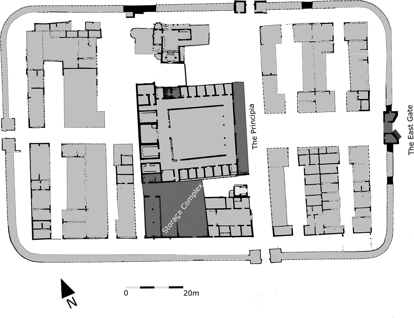
With very few garrison settlements in the region having been subject to archaeological prospection, the 14 ha Bu Njem settlement provides a rare insight into a garrison in the context of its extramural community. The excavation plan alongside satellite imagery (Figure 1), indicate the main gate to the military base (East Gate) served as the beginning of an axis, which culminated with a large rectangular structure at the eastern extremity of the settlement, aligned with the fort's East Gate (Figure 1:1). This likely represents a gate to the walled town, with the sand dunes perhaps concealing traces of a road. The rectangular structure was directly adjacent to a commercial complex (Bâtiment aux Niches Figure 1:2), one of a number identified in the garrison town (Rebuffat Reference Rebuffat1970b, 133–5). Having entered the interior of the base through the East Gate, the tentative route transformed into the fort's via principalis, leading past the principia building and an affiliated storage complex (Figure 2). The route would have turned 90 degrees at the groma and then led out of the fort through its South Gate. Satellite imagery shows traces of what could be a road leading out of the South Gate in the south-east direction (Figure 1:3), although it is unclear why having left the base the route turned again. While a limited portion of the layout of the settlement is known, at least one of its thoroughfares led via the fort.
Satellite image of Bu Njem with the outline of the settlement after Lenne, 1969. Key: 1. Tentative gate to the town, 2. Bâtiment-aux-Niches, 3. Road leading out of the fort. Google Earth, image © Maxar Technologies 2006.

Bu Njem, plan of the fort with discussed features picked out in dark gray. Base drawing of the fort after Lenne in Rebuffat Reference Rebuffat1989: 157, Figure 1.
That the fort was intertwined with the urban fabric of the town is further suggested by Rebuffat's survey of the settlement. The 1972 excavation identified building walls pressing up against the eastern and southern wall of the fort (Rebuffat Reference Rebuffat1977a, 50), although the question remains as to whether or notthese were in fact contemporary with the use of the fort. The proximity of structures would certainly minimise the defensive benefit of the ramparts. While the structures in the town represent organic urban growth with a multitude of divisions over the relatively short life span of the settlement, the wall of the garrison town is consistent in tracing the contour of the hill, perhaps signalling military oversight. On the north-eastern side of the settlement there is evidence for two phases of enclosures build against the settlement wall, one comprising of a 20 m long extension wall (Rebuffat Reference Rebuffat1977a, 50–51). Another irregular semi-circular extension is present in the north western corner of the settlement (Rebuffat Reference Rebuffat1977a, 50). Given the lower quality and fragility of the wall (Rebuffat Reference Rebuffat1977a), these might suggest individual agency of inhabitants in extending properties. The peripheral location and the size of the enclosures hint that they might have served in relation to camels and caravan movement (Guédon Reference Guédon2019, 178), or as locations for temporary keeping of herds, grazed in the hinterland of the garrison town. With the extensions suggesting their roles as stock enclosures, caravan stops, or property boundaries it seems that the town walls would only be appropriate for low level security purposes, fit for containment and surveillance of caravans and movement of people. Within the settlement, vaulted commercial structures (Bâtiment-aux-Niches) with counters suggest that the extramural community depended on more than provision of goods and services to the small garrison. Both the fort and the settlement became an important stopping point on long distance trade routes (Wilson Reference Wilson2012).
Study of textual material revealed the variety of cultural identities of the inhabitants of and travellers through Bu Njem (Cooley Reference Cooley2012, 274–84), but the community's composition, including the role of women, remains obscure. Only limited information regarding one known necropolis to the south west of the garrison town is available (Rebuffat Reference Rebuffat1970a, 31). The exception are two tombstones recording an adult woman and a young girlFootnote 6 as well as a funerary inscription commemorating a one-year-old child (IRT921). Much has changed in our outlook on extramural settlements since the excavation of Bu Njem, including a shift in thinking of fort walls as permeable to non-combatants as daily routine on military sites (Allison Reference Allison2013; James Reference James, James and Millett2001; Van Driel-Murray Reference Van Driel-Murray and Avebury1995). A joint approach to the fort and the extramural settlement is needed to understand Bu Njem in the context of its role in trade networks, as a connection point and as a local centre of authority. Such an approach is needed to understand Bu Njem as a place with multiple living communities, both military and civilian, whether they were separate, or integrated.
The garrison and the ostraca
An element of such a joint approach is identifying activity areas within the military enclosure relevant to understanding the military base as a point of contact. The concern for control of passage alluded to in the ostraca recording civilian convoys (Guédon Reference Guédon2019, 171–173) is further visible in Bu Njem's duty rosters listing guard locations (O. Bu Njem 13, 15, 22, 32), some of which can be identified on the ground. Beyond the exceptional texts, Bu Njem consists of a complex archaeological record that enables identifying some of such security-sensitive places. Information from the ostraca can be set against an analysis of visibility lines between buildings, key access points and features such as benches and obstacles to movement. These allow identifying points of presence and considering how these guided movement through the fort. The points of presence proposed below are associated with three key forms of activity; control of storage, differentiated control of access to areas in the base, and the management of the fort's key roads. Surveillance provided differentiated access to the fort's various areas and in this sense the frontier was actualised through the act of passage through that militarised space.
The East Gate
While we have no excavation in areas between the tentative gate to the settlement and the fort, the East Gate of the fort was subject to excavation (Figure 3). This was the main entrance to the base with the only double portal gate (Welsby Reference Welsby and Bidwell1988, 75). Garrison rosters, given their grammatical error of using nominative where accusative should be used, refer to guard at a gate (O. Bu Njem 13,15, 22 ad porta). The rosters are partial, and as seems to have been the general military practice, it is likely that all four gates were picketed (Fink Reference Fink1971, 13–16). To the left of the doorway outside the gate there was a 50 cm tall bench built against the entire length of the façade of the southern tower of the gate (Rebuffat Reference Rebuffat1967, 75). Considering its position immediately outside the perimeter of the base, its use is likely related to control of access into the military enclosure. Control of entry is consistent with the language of the ostraca recording entry of civilian convoys into the base, which we shall return to later. The position of the bench against the south wall of the tower gate hints at a locus for activity right at the entrance into the area of direct military control. The density of the extramural settlement could explain interest in control of access, but what could be the purpose of such a bench? One possibility is the bench belonged to a space for non-military parties wishing to enter the fort to sell goods to the base, in accordance with the ostraca, or to deal with Roman administration, for example petitioners waiting to see the commander.
The East Gate. After Rebuffat Reference Rebuffat1967: Fig. 5.

The principia building
The East Gate provided access to the via praetoria, with the headquarters’ building (principia) as its key structure (Figure 4). The façade of the principia building is fronted with an extending wall on its south end. The extension wall (4 m long) frames an L shaped outdoor bench (Rebuffat Reference Rebuffat1975a, Figure 1). On the opposite end of the façade of the building the French team encountered another projecting wall in a parallel position, although its course was not excavated (Figure 4). The two parallel extension walls are comparable in their location to forehalls known from the European context, and might suggest that the space, whether roofed or unroofed, could perform parallel functions; providing shade and protection from the elements, albeit sand and wind, rather than rain. Occupying the crossroads of the fort, an important circulation space, the majority of known forehalls are interpreted as shelter for activity spaces associated with the granary and the front of the principia building (Hodgson Reference Hodgson2003, 180–182; Rushworth and Croom Reference Rushworth and Croom2016, 288–289). Best comparison is provided by the forehall at Wallsend, in use between the mid-Antonine period and the early fourth century (Hodgson Reference Hodgson2003, 180). While most of the group of over 30 structures come from the British and German frontier, one of the better-preserved examples comes from Lambaesis (Rushworth and Croom Reference Rushworth and Croom2016, 289), the headquarters of Bu Njem's legionary contingent. The Bu Njem arrangement may be related to a post at the entrance to the principia building for inspections, issue of documentation, or control of movement on the via principalis, but the roles could be many. The space in front of the principia was at least 10 m wide. The extent of excavations at Bu Njem recorded on documentation does not rule out the existence of a covered forehall spanning the central T-junction of the fort (see the plan in Rebuffat Reference Rebuffat1975a). The available space could accommodate a forehall (Figure 4) slightly narrower than that at Saalburg (Baatz and Herrmann Reference Baatz and Herrmann2002; Schallmayer Reference Schallmayer1997).Footnote 7 The situation at Bu Njem could compare well with a small forehall across the via principalis at Dura Europos, which was also furnished with benches against its walls (James Reference James2019).
Potential extent of a putative forehall. Base drawing after Lenne in Rebuffat Reference Rebuffat1989: 157, Fig. 1 Drawing by S. James.

If there was not a roofed structure, and instead the space remained an open area, with the use of canopies, as is presumed was the case at the station in Gasr Zerzi (Rebuffat Reference Rebuffat1970b, 136–7), the space would temporarily increase shaded area and personnel capacity on site. Other uses of forts’ central spaces are known from other parts of the empire, traceable through a high resolution analysis of small finds (Allison Reference Allison2013, 150, 210, 278) and coin distribution (Birley Reference Birley2010). Although its forms and roles are not known well enough, the space was clearly an important functional area.
Inside the principia building there is a further set of features that indicate control of circulation. The principia building (Figure 5) was a two-storey building as evidenced through a staircase in the northern range of rooms (Rebuffat Reference Rebuffat1970a, 15). A limited access to the upper storey is conveyed by the presence of a short bench in a small (3.6 m × 2.5 m) square antechamber (Figure 6, room 2) to the staircase (Figure 6, room 1), looking directly onto the courtyard. Prolonged presence of more than one individual in the antechamber is indicated by deposits of ash and finds of clay lamps (Rebuffat Reference Rebuffat1970a, 16) as well as two game boards scratched on the bench. Rebuffat (Reference Rebuffat1970b, 108) suggested that the board with a pattern of squares 13 × 10 resembles the tabulae lusoriae. Considering their location, the boards were incised ad hoc. The secluded location of the boards, invisible from the courtyard, may indicate their incision was not legitimate either.
Plan of the principia building after Rebuffat Reference Rebuffat1975a: Fig. 1.

Staircase and an antechamber with a bench in the northern range of the principia building. 1. Staircase 2. Antechamber. Image adapted from Rebuffat Reference Rebuffat1975a: Fig. 1.

The unobstructed view onto the courtyard and the board games suggest interpretation as a waiting area, a location for controlling access into the upper storey and keeping the courtyard under surveillance.
The granary-storage complex
The granary-storage complex was a connected series of activity spaces encompassing the granary, a walled structure immediately to the south of the granary, and a room within the principia's western range that opened onto the granary. The complex was enclosed to the south by the back of the temple of the genius gholensis creating an open space which was accessible from the via principalis (Figure 2).
The two granaries were supported by characteristic buttresses (Rebuffat Reference Rebuffat1977a, 44). A depression in the sand between the granaries and the commanding officer's house (the praetorium) was originally seen as a walled courtyard (Rebuffat Reference Rebuffat1977a, 44), and later reinterpreted as a building of an unknown function based on discovery of further walls (Rebuffat Reference Rebuffat1989, 161). The structure, either as an open space or a roofed building, likely performed an ancillary function to the granary. This interpretation is supported by 1.6 m wide thresholds to both the western granary and the walled structure, suitable for loading large cargo. The structure was not fully excavated (Rebuffat Reference Rebuffat1977a, 44). This enclosed complex offered protection from windblown sand, which may explain why the western granary, instead of opening on the via sagularis, which would have been easier in terms of access, opens onto the more awkward, enclosed side between the granary and the principia building. Another rationale for the openings of the granary and the walled structure to be situated on the opposing ends of the block could be to minimise congestion.
A further feature of the complex is what is identified here as a sentry room (Figure 7). This was located in the western range of the principia building, directly overlooking the granaries, with the doors of both nearly fully aligned (Rebuffat Reference Rebuffat1977a, Figure 5). The room (room 4, Figure 7) cannot have been used in connection with the interior of the principia building as it does not open onto its courtyard and is only accessible from the open space located outside the granary. Original access between room 4 and room 3 was blocked, severing room 4 from the circulation in the principia building (Rebuffat Reference Rebuffat1970b, 113). Room 4 was furnished with a masonry table and bench. The table is near a partition wall dividing the room in two, and is reminiscent of the better preserved sloping desk in the principia's ‘scriptorium’. The table consisted of a raised masonry feature with stone slabs supported by iron studs (Rebuffat Reference Rebuffat1970b, 114). The bench in room 4 has no functional relation with the table, and instead provides a line of sight onto the passage between the principia building and the granaries. Prolonged presence is suggested by graffiti, including one of a gladiator (Rebuffat Reference Rebuffat1989, 162, Figure 5), or a soldier and a larger graffito of a line of soldiers on the western side of the partition wall, above the table (Rebuffat Reference Rebuffat1970b, 115), confirming that the partition and the table were added during the use of the building as a principia. The unskilled hand, its theme and location within the principia building may indicate the agency of a soldier. The opening onto the granary and the bench are original features, but the partition, the adjoining desk and the blockage of the door all belong to the same slightly later phase of the military use of the building (Rebuffat Reference Rebuffat1970b, 114–115). The table and the blockage of the original passage leading to room 3 suggest that room 4 could have been a guard post since its inception, perhaps commissioned as an office for a granary clerk at the time of the modifications, providing desk space and excluding the room from the circulation in the principia building. The ‘sentry room’ arrangement is not unique. The Severan phase at Wallsend again provides a parallel for Bu Njem. Here two small, boxroom chambers were added at the corners off the granaries, likely corresponding with monitoring of reception and issuance of supplies (Rushworth and Croom Reference Rushworth and Croom2016, 72). Other recently discovered guard chambers include one at the corner of the House of the Prefect at Dura-Europos, which too overlooked an internal gate (James Reference James2019). The Bu Njem rosters represent only a slim selection of the documents produced by the unit and do not provide a direct correlation with an assignment at the garrison granary. Yet, the preservation of Roman military documents as a class of evidence is so low that often where evidence does exist, only one instance recording a particular type of assignment is available across the empire (Fink Reference Fink1971). Evidence of references to granaries on military duty rosters come from Dura-Europos with two references of assignments of guards to horreum (P. Dur. 361.17; P. Dur. 363.3), interpreted as the garrison granary (James Reference James2019, 125). In a desert post storage as a necessity would be of concern in terms of its security, especially food provisions, which could justify supervision. The set up would also be a good fit for a location for reception and record keeping of supplies.
Putative sentry room and a clerk's office in the southern range of the principia building. Image adapted from Rebuffat Reference Rebuffat1975a: Figure 1.

Interpretation
Outdoor benches and short indoor benches providing direct vistas onto circulation spaces are interpreted here as signposting activity locations and as likely areas under surveillance. In the context of Italian cities outdoor benches have been interpreted as locations of leisurely activities, correlated with commercial spaces and as waiting areas for clients visiting their patrons (Hartnett Reference Hartnett2008; Viitanen and Ynnilä Reference Viitanen, Ynnilä and Ikäheimo2012, 146). As the military commander was the patron for his soldiers and a local source of authority, there is possibility for a parallel use of spaces by the east gate and outside the principia building as a reception or waiting area for non-military parties. Given the security sensitive locations near the gate to the fort and the principia building, and proximity to the ostraca's sentry posts, it is unlikely the benches discussed here were associated only with leisure, and rather they served as a means of controlling access and providing waiting and activity spaces in areas where people could be easily observed. The benches associated with the fort's gate, the front of the principia building, and the staircase antechamber certainly were not for the use of guards. This is suggested by the canon of military representations of soldiers arising from notions of military masculinity (James Reference James, Baker, Jundi and Witcher1999). Soldiers usually are depicted standing, except for representations on horseback, on ships, or wagons. The exception to that rule are military clerks, who would sit down to write. The context of room 4 in the principia building, overseeing the access to granary and the desk-like feature in the chamber might suggest that this was an office of such a clerk. References to guards in the Bu Njem ostraca suggest that the presence of guards in the spaces altered the accessibility of buildings through providing points of authority and gaze. In addition to rosters attesting the presence of guards at gates (ad porta) and guarding the standards at the regimental headquarters’ (ad signum, O. Bu Njem 13, 15, 19, 32) which with little doubt can be associated with the fort itself, other potential entries include a non-specified watch guard adseruator (O. Bu Njem 28) and adseruo (O. Bu Njem 14) (Marichal Reference Marichal1992, 79), providing further evidence of surveillance within the fort spaces.
Beyond duty rosters, military correspondence informed the praepositus about the garrison's daily traffic including the movements of soldiers, civilians and caravans (Marichal Reference Marichal1992, 99–106), although the extent of this surveillance is subject to discussion (Guédon Reference Guédon2019, 170–172; Rebuffat Reference Rebuffat and Moatti2004, 157–158). In contrast to the routine crossing of the fort perimeter by military personnel, the entry of civilians into the base as unusual occurrence warranted reporting on (O. Bu Njem 71–72, Guédon Reference Guédon2019, 171). As names of the individuals bringing cargo are not specified on the ostraca recording the passage of civilians, it has been suggested that the traders were free to offer their goods to the garrison (Guédon Reference Guédon2019, 174). It is more than likely that not all parties whose arrival at the check points was noted were permitted entrance into the highly security sensitive military enclosure. The language of the ostraca's introire, conveying specifically entrance through the garrison gate, suggests that the Garamantian convoy with barley (O. Bu Njem 72) entered the fort (Guédon Reference Guédon2019, 171). In contrast, the text recording the arrival of a cloth seller utilised a more ambiguous verb and did not record the identity of the arriving party (O. Bu Njem 73, superuenire). This lack of precision has been interpreted as signposting lack of the necessity to record the precise identity of the arrival as the convoy was likely passing through Bu Njem, but remained outside the fort enclosure (Guédon Reference Guédon2019, 175).
Surveillance of passage into the base attested in the ostraca is consistent with the proposal made here regarding a tentative reception, or waiting area furnished with a bench by the exterior of the East Gate. The bench was located against the north facing wall, likely to maximise shade coverage in afternoons, which are the hottest part of the day in summer months. The shadow cast by the remaining stone courses of the tower is visible in an aerial photograph (Figure 8). The outdoor bench in front of the principia building was also positioned against a north facing wall and benefitted from shade. The benches formalised otherwise ephemeral activity and beyond the concern for heat, windblown sand seems to have been an additional issue. In his dedication in the fort's bathhouse Q. Avidius Quintianus (IRT 918, 919) refers to the hardships of the desert, specifically the southern winds. A bench protected by a wall from the south offered shelter from the heat and windblown sand. Problems with sand are indicated by at least two additions of raised features in the fort, here interpreted as sandscreens, one in the principia courtyard near the main entrance (Rebuffat Reference Rebuffat1989, 165), and one blocking the passage between the pair of barracks in the south-west raetentura.
Aerial photograph of Bu Njem showing the shadows cast by the remaining courses of the walls. Photograph of UNESCO Libyan Valleys project (Barker et al. Reference Barker1996).

Access from the East Gate through the fort lead to the fort's central range, with an activity area framed by an L-shaped bench in front of the principia building. Rather than primarily a military assembly area, as earlier discussed roofed forehalls are sometimes viewed (Hodgson Reference Hodgson2003, 180–182), the feature at Bu Njem is interpreted here primarily in the context of monitoring of the circulation on the fort's key crossroad, providing a location sheltered from the sand and the wind for the benefit of those conducting business at the entrance to the principia building, and in context of control of access into the principia building itself. Given the intertwining of the garrison with the garrison town, the sheltered central junction would provide meeting space for organised military and civilian contact, that could easily be monitored through various lines of sight and presence in and around the principia building. Interpretation favouring control of militarised space is further supported through the identification of a secondary waiting room inside the principia building, controlling access into its upper storey.
An adjacent zone of supply-related activity consisted of a granary, an adjacent storage structure, a guard chamber overlooking the two buildings, and the open space in front of it. Its primary function is likely to be that of issuance of supplies. The tentative guard chamber near the granaries is an anomaly, rather than a common occurrence in Roman forts. At Wallsend the addition of two small rooms has been correlated with the increased administrative oversight as a result of keeping separate accounts for both the infantry and the cavalry contingents in the base (Rushworth and Croom Reference Rushworth and Croom2016, 72). One can only wonder if the alterations to the sentry room at Bu Njem can be related to such increased accounting pressure resulting from the changed occupation of Bu Njem from a single legionary vexillation to a mixture of two units. In addition to monitoring the issuance of supplies, the features may also represent part of a reception system of deliveries in the context of entry of supplies into the fort, facilitating the unloading and processing of cargo. We know that Severan frontier forts and their surrounding settlements were markets within their regional trade systems (Barker Reference Barker2002, 494; Wilson Reference Wilson, Wilson and Bowman2017b, 195). The military acquired some of the foodstuffs from the vicinity of the garrison as records of transactions indicate that local Libyan producers brought small quantities of their agricultural surplus of grain and oil (O. Bu Njem 76–78, 88 interpretation in Marichal Reference Marichal1979, 448; Marichal Reference Marichal1992, 100–104; Rebuffat Reference Rebuffat1977b, 409). Some could have been offered freely by the producers to sell to the garrison (Mattingly Reference Mattingly1986, 59), whilst others were either purchased, or requisitioned by the military. This is certain in the context of a delivery of oil (O. Bu Njem 75) sent by a procurator, likely purchased, or requisitioned from an oasis further away from Bu Njem (Marichal Reference Marichal1992, 100–104). It is worth observing that none of the texts in question specifically mention that these were monetary transactions, perhaps raising question whether some of the records could pertain to taxation in kind, rather than purchase. The ostraca suggest that the passage of garrison supply convoys through the fort was a frequent occurrence, with soldiers signing the entry of passengers and goods allowed access inside the perimeter of the base (Guédon Reference Guédon2019, 176; Marichal Reference Marichal1992, 103). Unless providing supplies for the fort, or in-kind tax, the question remains why was it necessary, or desirable, for caravans to pass through the fort rather than under its surveillance in the town?
This question brings us back to the statio camellariorum (O. Bu Njem 26.6). Statio is a generic term denoting guard post, leaving its precise function open to interpretation (France and Nelis-Clément Reference France, Nelis-Clément, France and Nelis-Clément2014, 12–15). Its three potential roles as places where military oversight would not be unexpected have been raised: places where local farmers sold produce to the military (Rebuffat Reference Rebuffat1977b, 408; Rebuffat Reference Rebuffat, Alföldi and Dobson2000, 240) a place for provision of water for the caravans (Marichal Reference Marichal1992, 112), a customs post (Marichal Reference Marichal1992, 112), and most recently, a tax assessment point (Wilson Reference Wilson, Wilson and Bowman2017b, 618–619). Military control of water in a point of passage of caravans was an important aspect of military presence in the area and the statio is understood to fulfil the role of a caravanserail (Guédon Reference Guédon2019, 178; Marichal Reference Marichal1992, 112), in a location near the garrison, but not within the garrison itself (Guédon Reference Guédon2019, 175). Enclosures on the edge of the garrison town have been suggested as possible caravan stop areas (Rebuffat Reference Rebuffat1979, 232). In their basic form as stops in the desert these consist of a building within a walled enclosure (Guédon Reference Guédon2019, 176). In the context of a thriving settlement, water points would offer business opportunities of providing food and services to the convoys for the civilian population. Conveniently, the Bâtiment aux Niches is adjoining the wall structure tentatively interpreted as the gate into the town (Figure 1). If, as it seems that not all groups took the same route, and perhaps only those dealing directly with supplying the army and depositing goods at the military stores would enter the military enclosure (Guédon Reference Guédon2019, 175), then is it possible that no one place performed all the functions linked to the statio, and that instead several places performed some of the roles? The survey of the archaeology of the fort shows there is much we still do not know. The areas within the fort discussed here are problematic to interpret, but they likely represent the most security sensitive locations of Bu Njem. The ostraca do not preserve documents recording the exit of parties out of the fortress, which may be a matter of haphazard preservation (Marichal Reference Marichal1992, 109).
Conclusion
I have tried to show that examination of legacy excavation material can aid our understanding of Bu Njem, particularly its urban character. As shown by other works in Libyan Studies (Ray and Nikolaus Reference Ray and Nikolaus2019), archival data provides research opportunities at a time when fieldwork is not an option with many archaeological sites inaccessible, damaged through conflict or industrial expansion. The study of fort architecture has historically tended to be based on morphology of structures (Allison Reference Allison2013, 16–18). Thinking in terms of activities through pathways, lines of sight, features, and graffiti shed light on the contextual particularities of the use of spaces. The principia building fit within a flow of traffic through Bu Njem's extramural settlement and into the military base. The existence of several zones of activity within the principia building, the storage complex and the entrance into the military base suited towards control of movement, reception of goods for storage and daily management of activities in the open spaces in the garrison, provide a glimpse into the workings of a military outpost in the pre-desert. The findings indicate that further to existing work on the ostraca (Guédon Reference Guédon2019, 170–175), control of access and of circulation featured visibly in the life of the garrison. The tentative locations for sentries and administrative activities fit within the role of the fort and its garrison town as a stopping point on trade routes, with the intramural locations interpreted particularly in the context of reception of supplies for the garrison.
Activities in the fort need to be viewed in the context of the extra-mural settlement to understand them. Scarcity of high-resolution excavation from extramural settlements in the region reflects the frontier research agenda at the time of the excavations of major sites, like Bu Njem. Studies from the period focused on fortifications and composition of garrison units. Increasing the understanding of cultural, social and economic complexities of extended military communities contributes to revising legacy approaches to the frontiers, bringing closer the archaeologies of Roman armies and local communities. A good example is a graffito from the Bâtiment-aux-Niches representing a ship being loaded with cargo with a figure of victoria above it, indicating that the inhabitants of Bu Njem garrison town displayed an awareness of the military base playing part in a long distance, trans-Mediterranean socio-economic network, signalling the role of this connectedness for the identity of a community relying on cross-frontier commerce. Given the small number of troops present and the rapid growth of the settlement, Bu Njem was largely an urban centre with a military-run logistic and administrative core, controlling movement along trade routes and waterpoints, managing supplies, and likely maintaining diplomatic relations with communities further south.
Control of circulation and access implied by sentry points illustrates that power can be written into the spatial culture of a place. The frontier was realised through people's experience of it as they came into contact with military power. This power influenced the military and the adjacent civilian communities. Papyri from other military sites evidence the presence of soldiers in garrison towns, which is also certain at Bu Njem. Roster of a unit in Egypt refers to soldiers supervising at the weight (ad pondera macelli) (PSI XIII 1307, col ii,13 see Fink Reference Fink1971, 200), indicating presence in commercial spaces, likely in a nearby town. Elsewhere reports from Dura-Europos may refer to supervising grain stores in the city by a centurion through a duty ad frum(entum), (P. Dur. 101 xvi, 17; P.Dur.101 ix 6, see Fink Reference Fink1971, 52). At Dura-Europos, soldiers were stationed at city gates as key access points in the town (James Reference James2019, 277–8; Welles et al. Reference Welles1959, 383). Could this have been the case at the town gates of Bu Njem, perhaps to be identified as the rectangular structure discussed here? By comparison with Dura-Europos (porta aquaria in P. Dur. 106,13) and Oxyrynchus evidence (P. Oxy I.43), it does not seem plausible that the garrison would have left the town gates unguarded. If the fort gate was not the first point of surveillance on arrival at Bu Njem, could more sentries be expected within the town? It is proposed that ostraca's statio camellariorum (O. Bu Njem 26.6) represents one of several locations within the military base and the town, and perhaps also their vicinity, that were subject to increased military oversight as part of Bu Njem's role in the monitoring of trade routes. Considering Bu Njem as a patch work of military controlled spaces with different degrees of security is a proposed way forward for a more holistic interpretation of the archaeology of the fort, the garrison town and beyond. The military base was a military-controlled nucleus within the larger walled settlement, rather than an entirely separate entity.
Acknowledgements
I would like to thank Simon James, Stéphanie Guédon, David Mattingly, Victoria Leitch, Alan Rushworth and David Breeze for their support, encouragement and input. I would also like to thank the team at CCJ, particularly Véronique Blanc-Bijon for their hospitality as well as the BILNAS library for allowing access to their holdings. Sincere thanks are owed to BILNAS and the British Academy for funding this research. I also thank the reviewers for their kind and helpful feedback. Any mistakes are my own.


 Open access