

1. Introduction
The ability to provide directions that others can follow is an essential component of wayfinding, or navigating through physical space.Footnote 1 When one is unfamiliar with a location or route, wayfinding is facilitated by what we here refer to as direction-giving: one speaker imparting directional information to another. In a typical direction-giving scenario, the direction-seeker requests instructions from a person thought to be familiar with a destination and thus able to provide information on how to reach that location.
Given the ubiquity of this speech act in daily life, direction-giving has been widely studied in psychology and linguistics across languages and communities (e.g., Collett and O'Shea Reference Collett and O'Shea1976, Allen Reference Allen2000, Hölscher et al. Reference Hölscher, Tenbrink and Wiener2011, Galati et al. Reference Galati, Michael, Mello, Greenauer and Avraamides2013, Bennardo Reference Bennardo2014, inter alia). Linguistic features of direction-giving expose the internal organization of the spatial systems of those who facilitate wayfinding through the language features that they use in addressing the direction-seeker. In this way, direction-giving may vary widely among direction-givers, even when they describe how to reach the same destination from the same geographic location as a starting point. Consider the responses in (1) of three different people who were asked the same question on the same day in the same community: Can you tell me how to get to Tim Hortons?
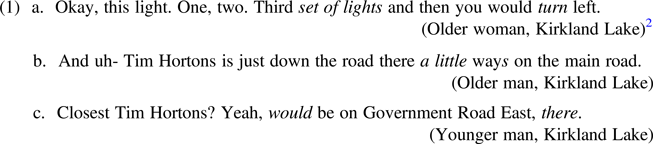
Notable linguistic features in (1) include lexical choice (use of the phrase ‘set of lights’ for ‘traffic lights’), verb choice (‘turn’), adverbial modification (‘a little’), a non-standard adverbial suffix (-s), aspectual modality (‘would’ in place of ‘is’), and discourse-pragmatic use of ‘there’. The variation present across linguistic systems in these few examples suggests that there are a wide range of variables involved in direction-giving and may indicate that this speech act is variable for Canadians, despite Canadian English having been traditionally characterised as homogenous (e.g., Labov et al. Reference Labov, Ash and Boberg2006: 217).
Because direction-giving is a speech act that extends over a stretch of discourse and involves interaction between participants, it offers a naturally-bound unit in which to examine multiple variables within the same general pragmatic context or semantic function. The differences observed in (1) may be idiolectal, but they may also be attributable to the social or identity affiliations of individual speakers. Previous research has demonstrated that individuals of differing genders and places of residence can and do vary in the nature of the linguistic features in their direction-giving. The most consistent finding is that gender plays an important role in how speakers give directions (e.g., Ward et al. Reference Ward, Newcombe and Overton1986, Pearson and Lee Reference Pearson and Samuel Lee1992, Lawton Reference Lawton2001, Napoleon Reference Napoleon2007, Ewald Reference Ewald2012) and that there is extensive individual variation (e.g., Kato and Takeuchi Reference Kato and Takeuchi2003). There is also some indication that country or region is implicated. For example, Mark and Gould (Reference Mark, Gould, Duchan, Bruder and Hewitt1995: 397) suggested that cardinal directions are used at higher frequencies by people in the Midwest than in other regions of the United States (see also Lawton Reference Lawton2001).
Despite this existing research, direction-giving has never been examined using quantitative variationist methods in Canadian English. While the aim of variationist sociolinguistics is generally to explore how the social reality of speakers impacts their use of language, examining direction-giving in particular may offer new insight into how the social characteristics of individuals are reflected in a speech act that exists specifically and primarily as a means of imparting wayfinding instructions from one person to another.
2. Direction-giving
Direction-giving has been extensively studied in cognitive psychology and linguistics. An individual's mental acts of spatializing have been found to determine the nature of linguistic features used in their direction-giving and other descriptions related to their physical and spatial awareness. For example, Linde and Labov (Reference Linde and Labov1975) demonstrated that the translation of spatial representation into speech acts is governed by a subset of cognition used for, among other things, describing apartment layouts. Direction-giving is known to be highly systematic: Allen (Reference Allen2000) reported that one's ability to provide and follow route directions depends on correct spatiotemporal ordering, ease of interpretability, and pertinent focus of the information presented in the directions. Each of these factors affects a person's ability to formulate a mental representation of directions, either before or after giving or receiving them verbally. Allen (Reference Allen2000: 352) described this representation as “basically a mental or situation model consisting of a sequence of actions-in-context.” Direction-giving is also strongly governed by the pragmatic requirements and goals of the speech act itself: Galati et al. (Reference Galati, Michael, Mello, Greenauer and Avraamides2013: 156) explained that mental models of route-following actions required to reach a destination are collaboratively constructed by both direction-giver and direction-seeker, who “adapt their strategies in ways maximizing the efficiency of communication.” In this process, pragmatic acts such as intention-signaling and communicating one's goal are integral not only to constructing mental models in discourse between participants but also to agreeing upon shared knowledge and understanding initial requests for aid in wayfinding (Golding et al. Reference Golding, Graesser and Hauselt1996). Overall, direction-giving has been shown to abide by a general principle of cognitive economy dictating that speakers aim to communicate directions with the most efficiency and the least effort, thus “optimally exploiting the available perceptual information while taking account of the requirements of the task” (Hölscher et al. 2011: 245).
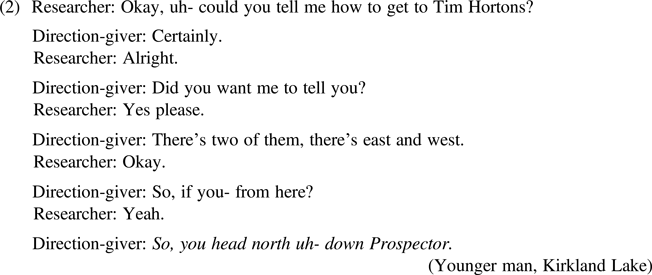
Given the importance of informational exchange in direction-giving, this has been studied as a speech act in which the function being carried out takes precedence over any other type of variation, suggesting that all individuals follow the same pragmatic ‘rules’. For example, directional utterances typically follow a sequentially organized structure of question-and-answer pairs whereby the direction-seeker poses a question regarding the route to some location and the direction-giver responds in kind. Psathas (Reference Psathas1986: 232), focusing on the answer component of these turn pairs, notes that direction-giving comprises two types of sequences: ‘how to get there’ and ‘where you are’. This is evident in the exchange in (2) where one segment seeks information about the wayfinder's starting point (From here?) and the other instructs the hearer on how to reach some location (So you head north uh- down Prospector). Direction-givers use these segments in order to spatially situate themselves and their interlocutors and to provide a wayfinding description based on a shared perspective.
Despite the pragmatic uniformity of turn-taking in direction-giving exchanges, different cognitive strategies have been found to influence the particular linguistic features used. In cognitive linguistics, considerable research has focused on varying preferences for frames of reference across languages (e.g., Levinson Reference Levinson2003 and many others). Research by Hund and Padgitt (Reference Hund and Padgitt2010) and Hund et al. (Reference Hund, Schmettow and Noordzij2012) describes two types of direction-giving strategies that depend on the cognitive preferences of individual speakers. The first, called ‘orientation’ strategies, correspond to a relative frame of reference. The second, called ‘route’ strategies, correspond to an absolute frame of reference. Orientation strategies involve directing and anchoring one's self in reference to a mental map and cardinal points, and rendering directions as if from this bird's-eye perspective (for example, Go north two blocks, then travel west on Main Street). Route strategies instead involve directing one's self in reference to the immediate environment (for example, Turn left at the school, and then go straight until you see the pond on your right side). Orientation strategies utilize global reference points: for example, the use of cardinal directions (e.g., north, south, east, west) and reference to proper street names (e.g., Main Street, Prospector). Route strategies include reference to locations and features of the environment situated with reference to the wayfinder through deictic expressions: relative directions (e.g., left, right), prepositions (e.g., behind, above, past), and generic street names (e.g., that street, the next road). The language of direction-giving may thus vary based on the cognitive and spatial perspective an individual speaker prefers. Elements of each strategy can be (and frequently are) combined in a single direction-giving utterance (e.g., Go south, then turn left at the bank). However, and despite their ability to use and parse combinations of route and orientation strategies, individual speakers may still exhibit an overall preference for one set of strategies or another.
Gender effects are also widely cited as determining direction-giving. Multiple studies (e.g., Lawton and Kallai Reference Lawton and Kallai2002, Hund and Padgitt Reference Hund and Padgitt2010: 563) have found that men are more likely to use orientation strategies while women are more likely to use route strategies. Men have in some cases been found to use a higher proportion of cardinal directions in their direction-giving than women (Ward at al. 1986, Lawton Reference Lawton2001). However, not all of the findings in the literature agree with such a partitioned view of gender. In studies by Harrell et al. (Reference Andrew and Hall-Hoffarth2000) and Lawton (Reference Lawton2001), women have been found to use a higher frequency of reference to landmarks than men. Hund and Minarik (Reference Hund and Minarik2006) found that neither men nor women outperformed each other on wayfinding tasks involving cardinal directions or landmarks, and also suggested that no significant difference exists for directional preferences among men and women. Ewald (Reference Ewald2010: 2556) also found no significant difference between men's and women's use of landmarks in direction-giving and found few significant differences between men and women as direction-givers overall, noting that relative and cardinal directions were in use by men and women at similar frequencies. Additionally, Brown et al. (Reference Brown, Lahar and Mosley1998) reported no significant difference due to gender or age in the strategies employed in direction-giving, and Sing and Kalingga (Reference Sing and Kalingga2011) found that women used a higher proportion of both cardinal directions (an orientation strategy) and landmarks (a route strategy) than did men, suggesting that no one set of strategies is favoured by any particular gender.
Aside from possible effects of social factors, previous direction-giving research has also demonstrated that place, including multiple elements of geographic locality, may affect how direction-giving is achieved. The first conception of place is a tangible one: how the spatial layout of a given community may determine the performance of direction-giving. Space in terms of physical arrangement of the landscape has been examined in multiple previous studies, with research into direction-giving via map reading demonstrating that increased ‘route complexity’ (the degree to which one's route to a destination is variegated in physical space rather than consisting of straight lines) led to an increased amount of both cardinal direction and landmark use in maps drawn for wayfinders (Harrell et al. Reference Andrew and Hall-Hoffarth2000). Importantly, Lawton (Reference Lawton2001) also discovered a parallel between the directions used by speakers and the layout of their geographical region: people in areas with more grid-like roads used a higher proportion of cardinal directions than those in less grid-like communities. This suggests that speakers take advantage of the direction-giving strategies better suited to describing their environment – for those in a community whose paths and roadways correspond to cardinal points on a map, orientation strategies may be more frequently used, while route strategies may be preferred where cardinal directionality corresponds less directly to the community's layout.
The second conception of place that may be relevant in direction-giving is the intangible one. This is sense of place in terms of one's degree of ideological connection to one's place of residence or place of origin. If place is relevant to a speaker's identity, they may choose to express this affiliation linguistically through use of features that reflect their meaningful or relevant geographical allegiance. This type of local affiliation has been found to be predictive of linguistic variation in a wealth of previous sociolinguistic research (e.g., Ito and Preston Reference Ito and Preston1998, Johnstone et al. Reference Johnstone, Andrus and Danielson2006, Knee and Van Herk Reference Knee and Van Herk2013, Carmichael Reference Carmichael2014, Sneller Reference Sneller2019, and many others). Most of this research has focused on determining how alignment or distancing from place as part of a speaker's identity is achieved through phonological variation, though some (e.g., Hazen Reference Hazen2002) have focused on morphosyntactic variation. In Ontario, Canada, a growing body of research is demonstrating variation in regional varieties of English (e.g., Tagliamonte Reference Tagliamonte, Green and Meyer2014, Tagliamonte and Denis Reference Tagliamonte and Denis2014, Tagliamonte and Jankowski Reference Tagliamonte and Jankowski2018). Recently, Schlegl (Reference Schlegl2019) and Bigelow (Reference Bigelow2019) have suggested that speakers in Northern Ontario who align their identities with ideological aspects of Northernness (e.g., outdoorsiness, toughness, and rural masculinity) use specific linguistic variants (e.g., negative concord, or monophthongal /o/) to signal their Northern identity. Based on these results, it is reasonable to suppose that regional differences based on speakers’ regional identity affiliations may emerge in direction-giving.
Given the state of knowledge about direction-giving described above and the recent insights from Ontario dialects, this article undertakes a sociolinguistic study of direction-giving across Ontario. Broad social characteristics such as age and gender of speaker will be considered, in order to test the relative importance of these factors in conditioning the variable linguistic features of direction-giving. In addition, the relatively broad coverage of location and landscape in this study (five communities across 850 kilometers) enables us to test the effect of place, both tangibly (through consideration of the physical features of the community such as size and layout) and intangibly (through investigating regional affiliation and rurality compared to urbanity).
If direction-giving is a purely pragmatic act for speakers of Ontario English, then the importance of physical factors of the environment should prevail, with layout of the community playing a stronger role in determining which direction-giving features are chosen by speakers in this data. However, if the pragmatically governed and goal-oriented act of direction-giving is a medium for identity expression for speakers, then we expect that social factors will be relevant in explaining the distribution of linguistic features in direction-giving.
3. Methodology
In this section, we detail the data used in this study and the factors contributing to the data analysis.
3.1 The Tim Hortons corpus
The study is based on what we will refer to as the Tim Hortons Corpus (THC), which was collected by a team of fieldworkers between May 16 and June 31, 2016 in various communities across Ontario, Canada. The corpus is so named because of its reliance on the existence of Tim Hortons, a ubiquitous Canadian fast food restaurant chain, as a common destination for directions sought from participants. The communities in which data gathering took place are listed in Table 1, and a map of these locations within Ontario is shown in Figure 1.
Locations of Ontario communities (Google Maps 2019)


In Table 1 and all following visualizations of cross-community distributions within this article, communities are ordered latitudinally, from those located furthest south (Toronto) to furthest north (Kapuskasing). These locales were chosen as data-gathering sites to enable a comparison across community types, from a large urban center (Toronto) to smaller towns both incrementally further northward and increasingly remote from the main financial/industrial center of the province, across different socioeconomic compositions and economic bases (whether mixed economies, mining towns, or communities formed around logging and paper pulp processing). This comparison is essential not only to investigating whether rural or Northern and urban or Southern communities differ in direction-giving, but also to examining the possibility of diffusion of linguistic features from a larger urban center to smaller, outlying rural communities (see also Tagliamonte Reference Tagliamonte, Green and Meyer2014).
In each community, fieldworkers approached people in public places with a greeting and a request: Hello, can I ask you a question? Once the local status of the individual was established and the person had consented to participate in the study, the fieldworker asked, “Can you tell me how get to Tim Hortons?” Although fieldworkers were instructed in how to phrase the question, there were some minor variations. Regardless, participants were aware that a request for directions was being made. Tim Hortons was chosen as the standard destination for direction-giving in this study because virtually every city and town in Ontario contains at least one of these fast food restaurant franchise locations.
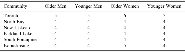
Individuals were selected based on a sample design of at least 16 speakers per community, balanced by age and gender and divided among older and younger individuals, as shown in Table 2. This yielded a total of 102 individuals. To ensure coverage of regional differences, each participant was asked to confirm their localness to the community. Age and gender were assessed visually and coded as ‘older’ or ‘younger’ (either above or below 35 years of age) and ‘man’ or ‘woman’ based on the speaker's adherence to cultural gender norms (dress, mannerisms, grooming, etc.).Footnote 3 The data-gathering process was purposefully designed to be unobtrusive, given the nature of the brief encounters in this street-based data collection, and the fact that participants who were stopped to provide directions were usually already on their way to some destination, with little time to spare. For this same reason, self-report data on other social characteristics (e.g., ethnicity) was not collected. The response of each individual to the request for directions to Tim Hortons was audio recorded with permission and later transcribed, and text transcriptions were used as the basis for analysis.
Tim Hortons sample design
3.2 Linguistic variables and coding
The THC comprises over 12,000 words. The distribution of words in the corpus is in line with other large corpora of vernacular speech from Ontario such as the Toronto English Archive (TEA) (Tagliamonte Reference Tagliamonte2003–2006), with top-ranked words by frequency being you, to, a, the, and and. However, the THC is distinguished by a heightened use of proper nouns such as Tims, a common nickname for Tim Hortons (N = 331), relative directions such as right (N = 196) and left (N = 128), and other words typical of direction-giving and description of physical places such as there (N = 138) and lights (N = 61) as in ‘traffic lights’, etc. Selection of variables for analysis was based on previous research on direction-giving (e.g., comparison between route strategies which use relative directions such as left, right and orientation strategies which use cardinal directions such as north, south). The presence and frequency of linguistic features that were unique to the data motivated the choice of some features (e.g., turning verbs) as potential determinants of community differences.
The quantitative analysis presented here, like all variationist sociolinguistic analyses, takes as foundational the concept of the ‘variable’. This is classically described as a linguistic feature that can be expressed in multiple ways – ‘different ways of saying the same thing’. The definition and study of the sociolinguistic variable has been subject to considerable debate in the history of the field (see Lavandera Reference Lavandera1978, and the response to Lavandera in Labov Reference Labov1978, as well as later work by Cheshire Reference Cheshire1987, among others). However, though the field has expanded to encompass all types of linguistic phenomena including discourse-pragmatic variation, this construct endures as the foundational means to study variation. Direction-giving is no exception. Though a speaker may choose to utter directions using a variety of different structural, lexical, or phonological forms, certain regularities (e.g., the use of consistently variable forms or lexical items) appear, which make the study of direction-giving not only ideal for sociolinguistic scrutiny but also for cross-variety comparison.
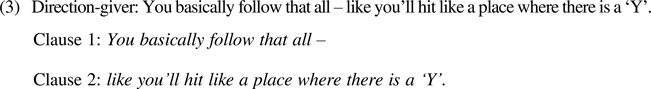
In order to extract the linguistic features from direction-giving utterances, the data were divided into clause-level strings which we will refer to as ‘clauses’. Canonical clause boundaries, including points of speaker reformulation, were considered to be relevant breaks for segmentation. For example, the utterance in (3) was divided into two clauses, with the boundary point being the beginning of the reformulation (following all).
Each clause within an individual's total direction-giving data was considered to be a context in which direction-giving could occur, and thus a potential site of variation, since any given phrase used could potentially contain one or more of the variables of interest detailed below. Each clause was coded for age, gender, and locality, the last of which was categorized by community (Toronto, North Bay, New Liskeard, Kirkland Lake, South Porcupine, or Kapuskasing) and by region (Toronto or Northern Ontario).
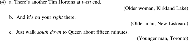
The primary linguistic variable under consideration is direction type. This variable compares the use of cardinal directions (e.g., north, south, west, east, southwest, northeast, etc.), as in (4a), with the use of relative directions (e.g., left, right, up, down, or straight), as in (4b), or the use of a combination of cardinal and relative directions in a single phrase (e.g., north up, west down, etc.), as in (4c).
In comparing use of cardinal and relative directions by speakers of different ages, genders, and localities, this variable allows us to specifically test the findings in the literature regarding whether gender, age or place correlate with use of route strategies (relative directions) or orientation strategies (cardinal directions).
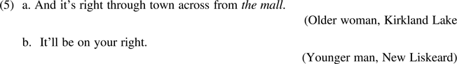
The second linguistic variable is reference to landmarks. A landmark constitutes a feature of the environment that is objectively fixed in one position in space, such as a specific building, park, monument, or natural feature of the land (e.g., a named body of water). Because of the fixed positions of landmarks in physical space, reference to them constitutes an orientation strategy. Any clause containing reference to a landmark, as in (5a), was compared to those with no reference to landmarks, as in (5b).
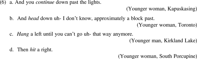
The choice of directional verb is highly variable. Accordingly, the main verb indicating movement (if present) of each clause was coded for two factors. The first encodes the type of verb of movement: each distinct lexical verb denoting straightforward movement to or from a location (e.g., go, head, walk, continue, etc.) was coded separately. Some of these variants are shown in (6a–b). The second encodes different distinct turning verbs (e.g., hit, turn, hang, etc.), as in (6c–d). Some lexical verbs in the data have multiple uses: for example, take can be used to denote movement along a particular path toward a destination (e.g., Take the highway to the store) as well as to denote turning in a certain direction (e.g., Take a left). Where verbs had the same surface form but different meanings, each one was coded as a separate variant within its semantic functional group (either movement or turning).
The fourth variable codes types of reference to roadways: proper street names, as in (7a), or generic street or road names, as in (7b). Reference to proper street names constitutes an orientation strategy, since these names exist independent of the location of the speaker. Reference to generic street names instead constitutes a route strategy, since the denotation of ‘this street’, ‘that road’, or ‘the next alley’ (etc.) changes based on the physical position of the speaker.
The speech of the fieldworkers, as well as openings and closings in the direction-giving discourse and other extraneous comments by participants as in (8a), were not included in the analysis. Discourse-pragmatic markers and non-lexical sounds (such as uh/um, hesitations, and false starts) were transcribed faithfully and included, as in (8b–c).
Clauses varied greatly in terms of content. While some contained multiple tokens of the variables under investigation, as in (9a), others had only one or two, as in (9b), or even none. In this data, no token included multiple instances of the same variable. Example (9a) includes one instance of verb of motion (take), one combined relative and cardinal direction (east down), and one proper street name (Bloor). However, (9b) contains only verb of motion (turn) and one relative direction (left).
4. Results
The results are based on a distributional analysis of the 715 clauses of the THC corpus, each of which was coded for age, gender, community, region, and for occurrence(s) (or lack thereof) of direction type, landmark reference, use of movement and turning verbs, and street name reference. We supplement these results with a study of turning verbs in the Ontario Dialects Project data (Tagliamonte Reference Tagliamonte2013–2018).
4.1 Direction type
Recall that direction type is the most prominent linguistic feature previously examined in studies of direction-giving. Directional words occurred in 360 of 715 clauses in the THC data, making directional words (whether cardinal or relative) the most frequently used of the linguistic strategies we studied.
Figure 2 displays bar plots which illustrate the counts of cardinal directions, relative directions, and a combination of both types of directions across regions. The left facet of Figure 2 shows the counts for direction type in Toronto (N = 191), while the right facet shows the counts in all Northern Ontario communities combined: North Bay, New Liskeard, Kirkland Lake, South Porcupine, and Kapuskasing (N = 270). Cardinal directions were used much more frequently in Toronto than in Northern Ontario.
Type of direction by region (Counts only, Total N = 360)
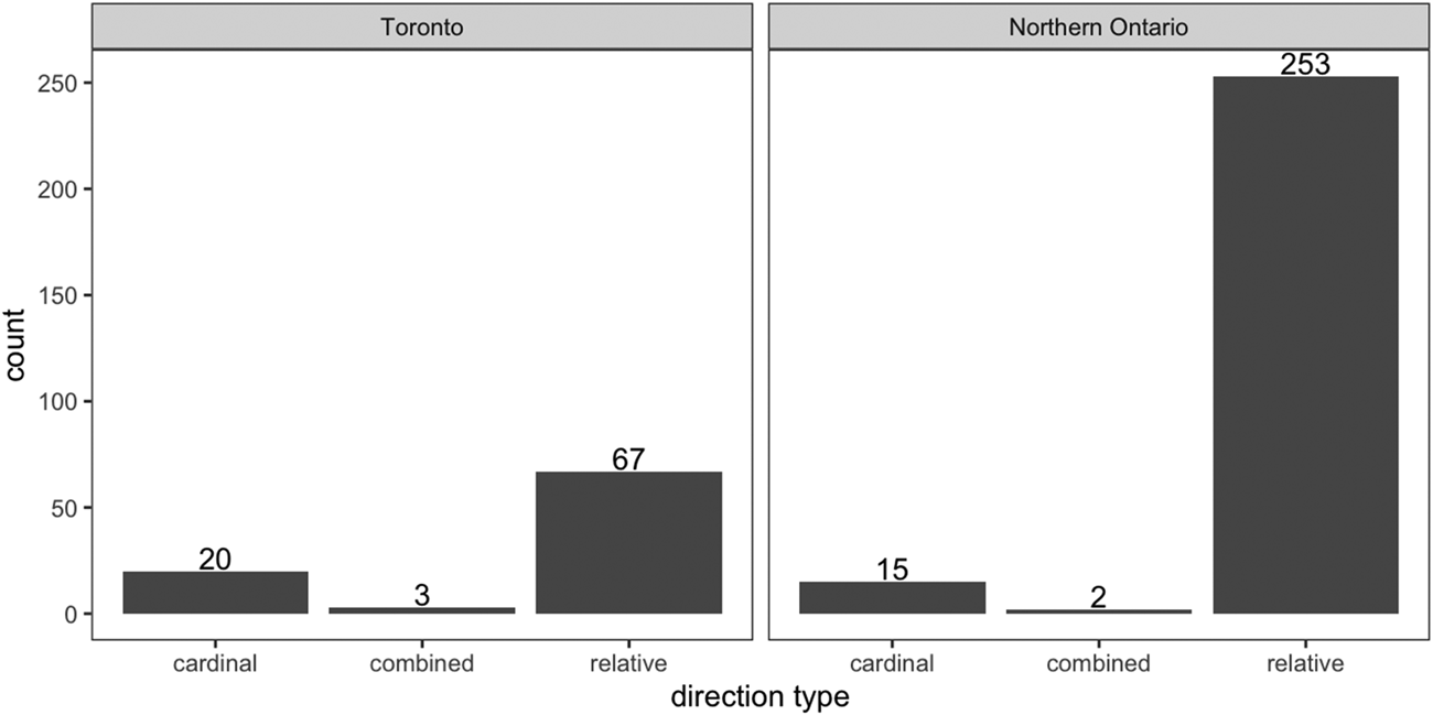
Figure 3 displays a breakdown of directional use in individual communities by frequency. In most of these communities, relative directions were (or were nearly) the sole variant used. Toronto and Kirkland Lake were exceptions, with speakers in these communities having used relative directions around 75% of the time, cardinal directions around 20% of the time, and a combination of relative and cardinal directions around 3 to 4% of the time.
Type of direction by community (Frequencies only, Total N = 360)
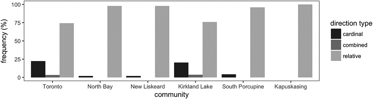
While both relative and cardinal directions could be used in a single utterance (e.g., Go south down Bloor), this occurred only in the two communities (Toronto and Kirkland Lake) where cardinal directions already constituted a non-negligible percentage of overall directional use in direction-giving. In other words, speakers were unlikely to combine cardinal and relative directions where they did not also use cardinal directions frequently on their own.
The samples drawn from each community were stratified by age and gender as part of the sample design in order to test their influence as potential determinants of direction types. Tables 3 and 4 show crosstabulations of direction type by age and gender in Toronto and Northern Ontario respectively. Though the number of participants present in some age and gender subgroupings is low, these distributions allow us to make some inferences about how speakers facilitate wayfinding by direction type.
Cross-tabulation of direction type by speaker age and gender in Toronto

Cross-tabulation of direction type by speaker age and gender in Northern Ontario

In Toronto, men used more relative directions than women, while women used more cardinal directions than men. Women's use of direction types was similar regardless of their age, but older and younger men differed in that older men used double the rate of cardinal directions than younger men. This means that the minority variant (cardinal directions) was in use mostly by women of both age groups and slightly less frequently by older men, with younger men lagging behind. In Northern Ontario, each sub-group had nearly identical usage rates for each directional variant except for younger men, who used at least twice the rate of cardinal directions as any other age or gender group. In both regions direction-giving clauses containing both cardinal and relative directions were rare, but where they were present, they were used exclusively by younger speakers.
4.2 Landmarks
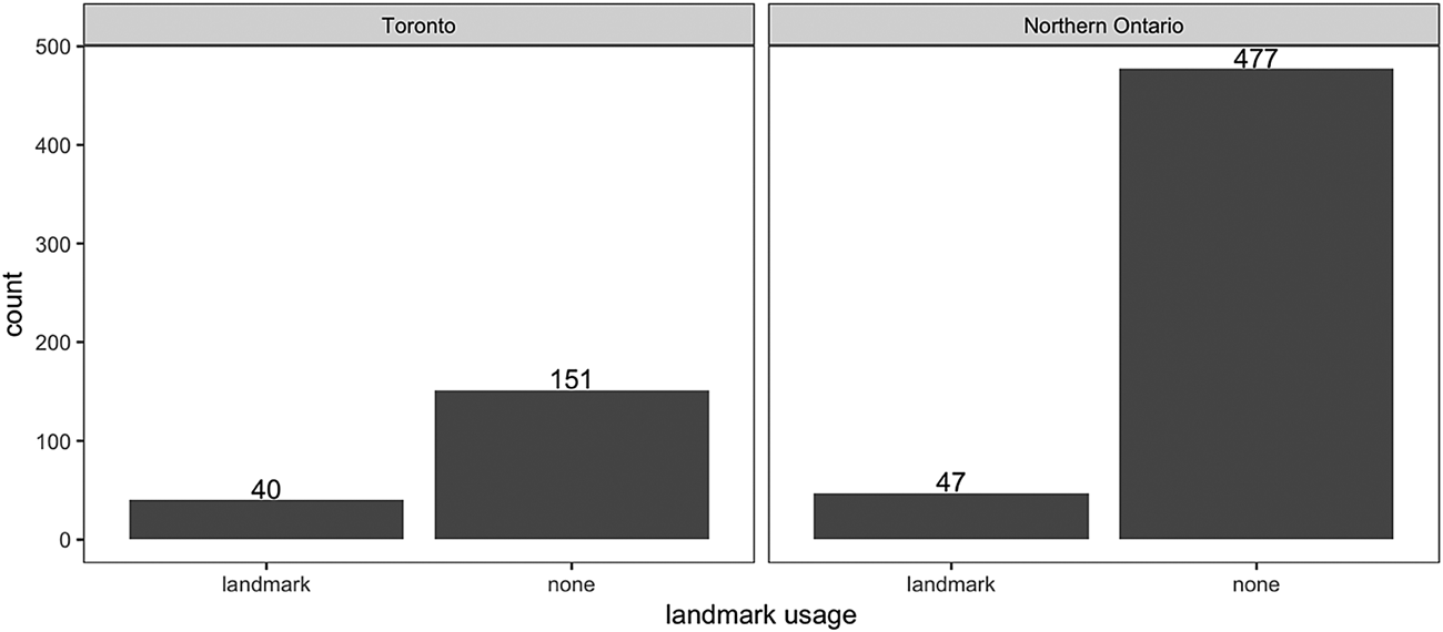
Figures 4 and 5 display the use of landmarks in direction-giving. Figure 4 shows raw counts contrasting regions: Toronto (Southern Ontario) vs Northern Ontario. Figure 5 displays the relative frequency of landmark use in each community. Unfortunately, the low frequency of landmark use overall (87 tokens across all communities) and the similarly low frequency of many of the remaining linguistic variables and variants present in this analysis prohibits cross-tabulations of the data by age and gender.
Landmark use by region (Counts only, Total N = 715)
Landmark use by community (Frequencies only, Total N = 715)
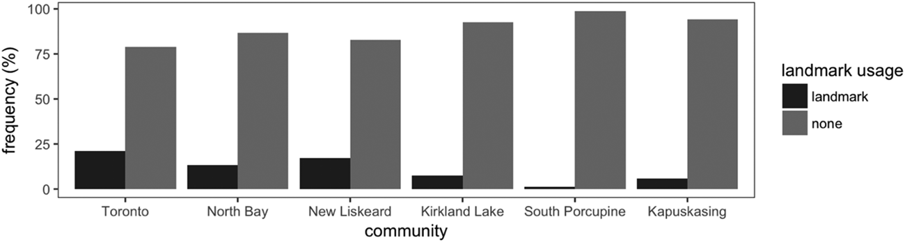
However, it is possible to use Figures 4 and 5 to assess the impact of place on the use of landmarks (an orientation strategy). In Toronto, the use of landmarks was nearly twice as high as in Northern Ontario. When all communities are viewed separately as in Figure 5, contrasts become visible. Although Toronto is the place where landmarks were used most often, there is a gradient pattern among Northern communities whereby North Bay and New Liskeard (the two southernmost of the Northern communities) patterned with Toronto in their usage rates of landmark reference, while direction-giving in more northerly communities featured fewer landmarks.
4.3 Verbs
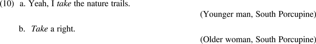
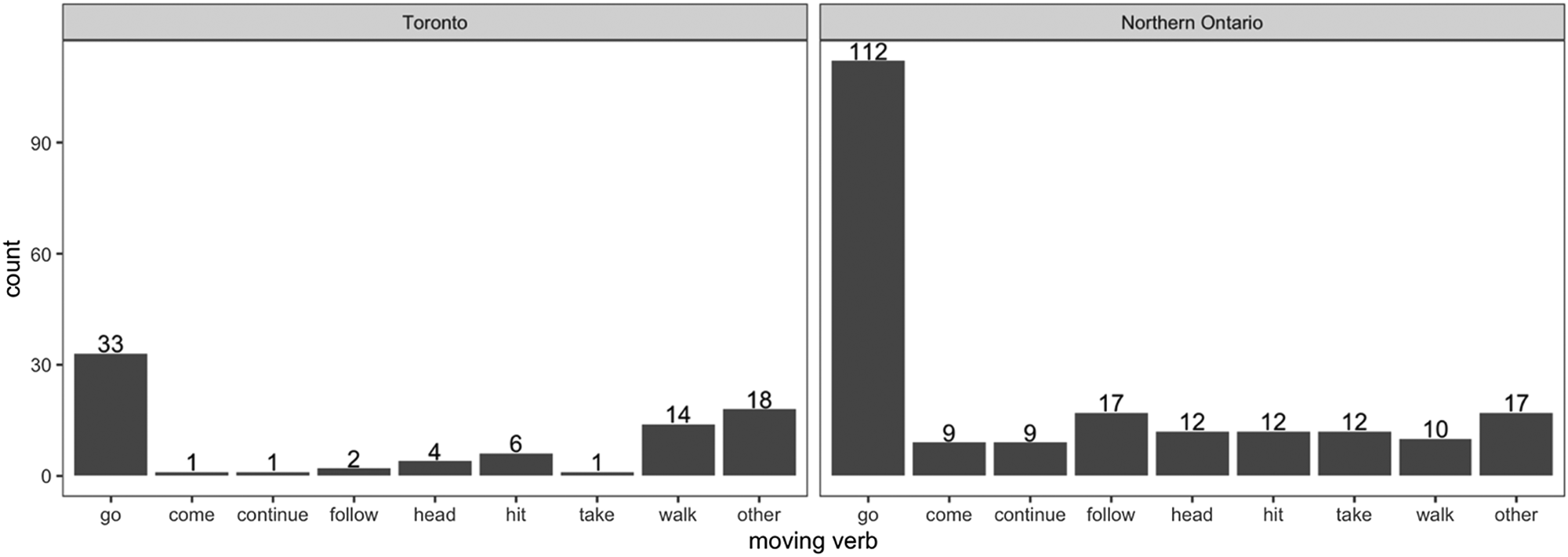
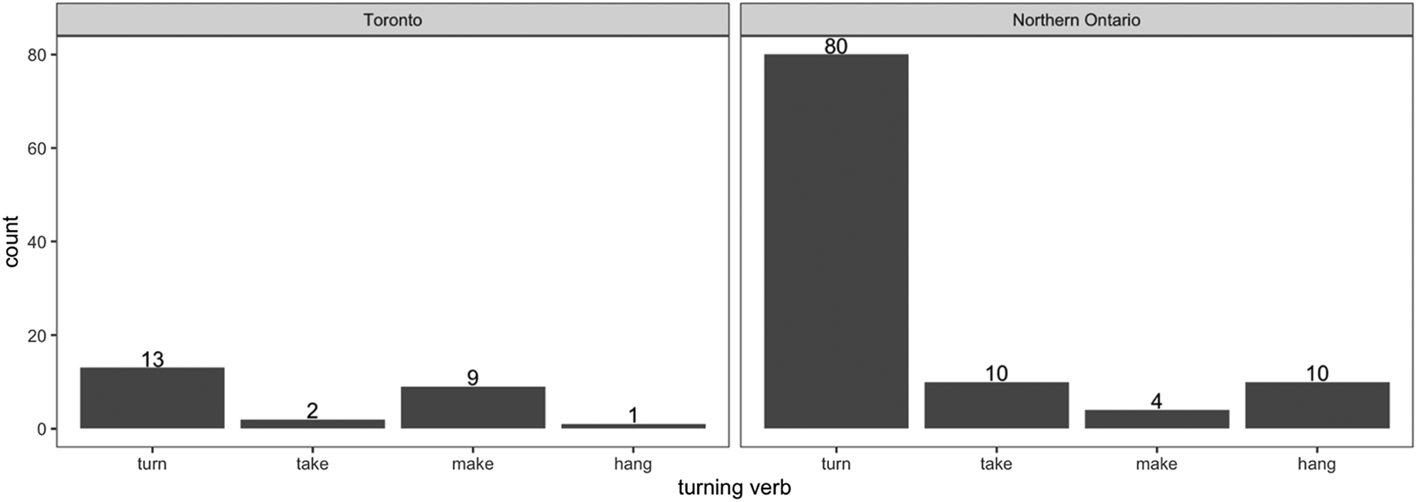
Verb choice in direction-giving is to our knowledge a novel linguistic variable whose use is specific to this pragmatic context. As explained above, these verbs were grouped into two types: ‘moving verbs’ indicating movement toward a fixed point, and ‘turning verbs’ indicating a change in direction during movement. Moving verbs included go, come, continue, follow, head, hit, and walk, while turning verbs included turn, make and hang. Moving verbs with less than ten tokens are grouped together under the label ‘other’ in these distributions – this category includes additional variants do, enter, merge, keep, get, drive, leave, catch, bring, run, pass, cross, pull, make (indicating movement toward), and park. Also included among variants of both moving and turning verbs was the surface form take, which can have either a moving or turning meaning. Instances of take indicating simple movement, as in (10a), were included within the moving verbs category while instances of take indicating turns, as in (10b), were included within the turning verbs category.
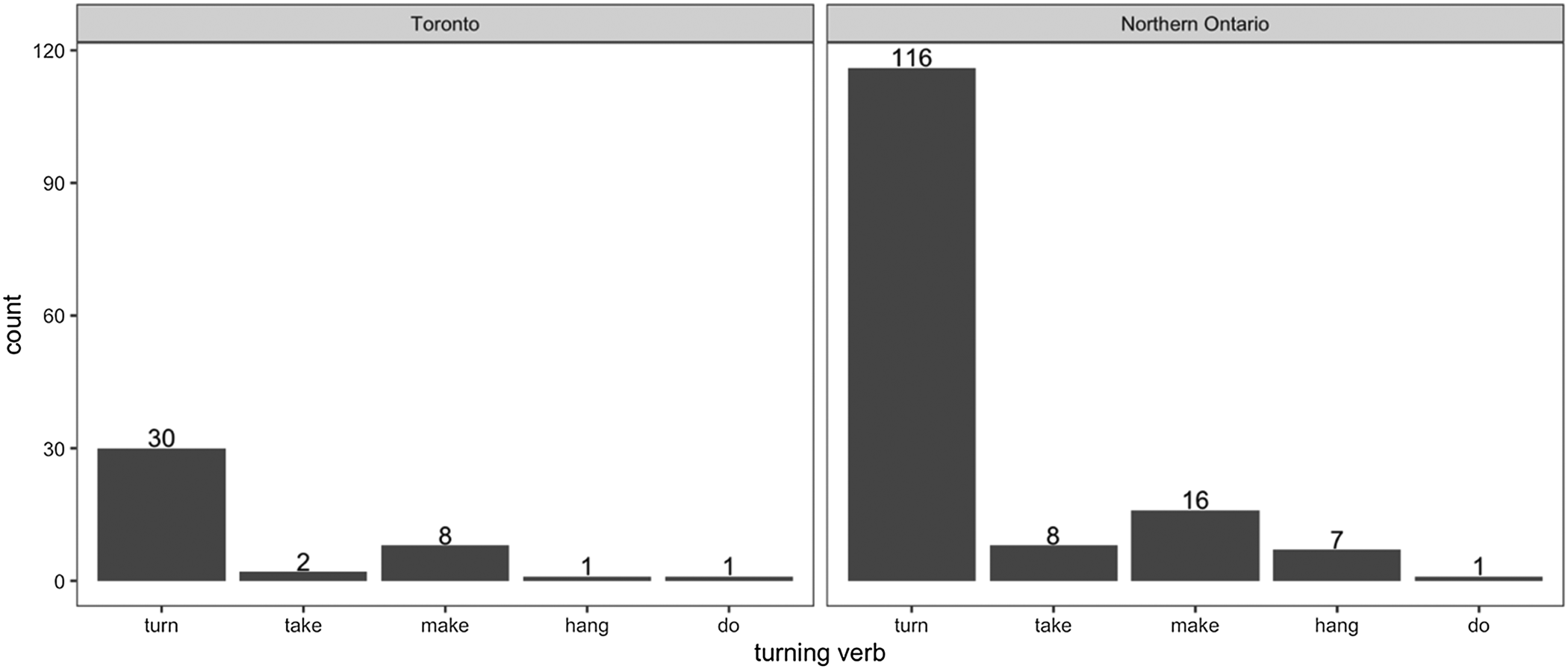
Figures 6 and 7 display the results for moving and turning verbs. Figure 6 shows that the verb go is overwhelmingly the most frequent in both regions, although each of the minority variants was present to some degree. Despite low frequencies of turning verbs in the data, regional differences emerge. In Northern Ontario, use of turn far surpassed any of the other variants, while in Toronto make was nearly as frequent as turn. In Northern Ontario, turning verbs take and hang were fairly robust while in Toronto these were virtually absent. While there are too few tokens of minority verb variants to allow cross-tabulation of the data here, it is notable that all ten tokens of hang in Northern Ontario were produced by men: two by older men and eight by younger men, and the single token of hang use in Toronto was also by a younger man. General cross-tabulation of social and geographic factors by verb (not shown) indicate that age and gender do not influence the choice of verb, with the exception of hang.
‘Moving’ verb use by region (Counts only, Total N = 290)
‘Turning’ verb use by region (Counts only, Total N = 129)
4.4 Street names
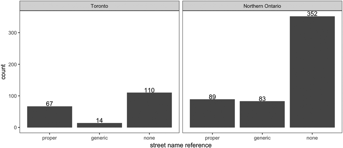
Figures 8 and 9 display the counts for use of street names. These figures make visible the fact that Northern Ontario speakers made nearly equivalent use of generic street names as they did proper street names in giving directions, while speakers in Toronto made much more frequent reference to proper than to generic street names.
Use of street names by region (Counts only, Total N = 715)
Use of street names by community (Frequencies only, Total N = 715)
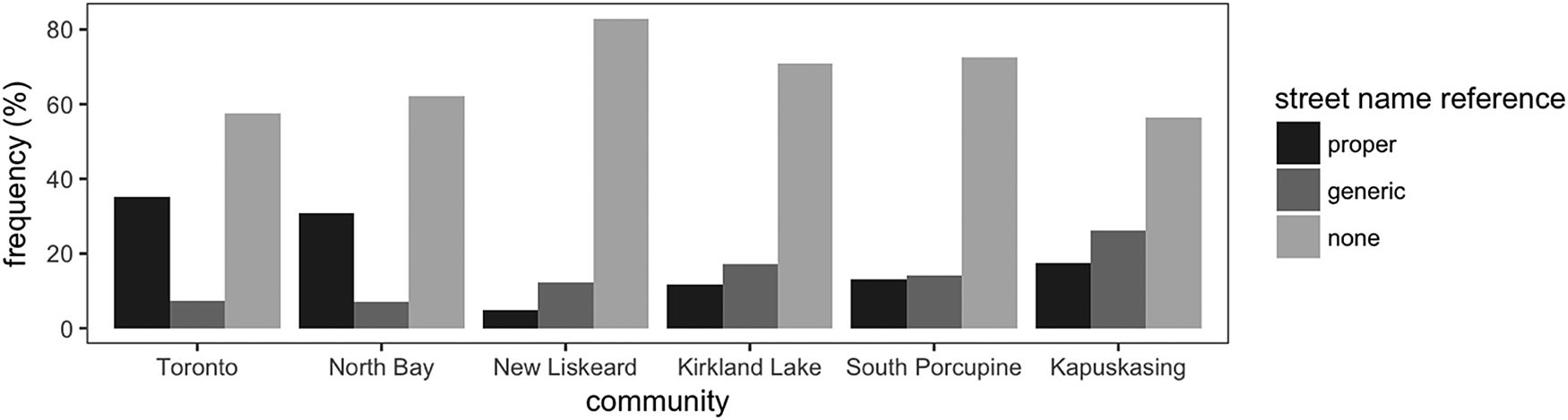
Figure 9 shows that while generic street name reference comprised approximately 7% of the utterances in Toronto, in Kapuskasing, this was a notable 26% – the highest rate among all communities. There is a stepwise increase in generic street name use from south to north. In contrast, proper street name reference was highest in the two largest (by area and population) and most southerly communities, Toronto and North Bay.
4.5 Comparison with Ontario dialects Project Data
Analyses of the THC are based on data collected from 102 individuals over several weeks and hundreds of kilometers. Still, the token counts are well below most contemporary variationist studies and cell sizes, particularly for social factors, rendering interpretation of these trends suggestive at best. One way to mitigate this problem and to lend support to our interpretations is to test these findings in comparable corpora of vernacular speech from the same region. However, such comparisons are complicated by the fact that the particular variables within this analysis (e.g., cardinal directions, reference to landmarks) are pre-disposed to direction-giving speech acts, which may be relatively infrequent in sociolinguistic interview data which are not designed to elicit direction-giving. To this end, we targeted the feature that was most amenable to quantitative study in a larger corpus: turning verbs.
All verbs of turning were extracted from the Ontario Dialects Project (ODP) data (Tagliamonte Reference Tagliamonte2013–2018, Reference Tagliamonte, Green and Meyer2014), a data set that comprises over 11 million words of spoken conversation from individuals in over 20 communities across Ontario, with the individuals who make up these materials having been born between the late 1800s and the early 2000s. In this data set, we found only 191 tokens of turning verbs. This highlights the extreme rarity of these verbs in general and the fact that turning verb tokens drawn from the THC capture a sample that is likely more representative of this discourse-pragmatic context than its small numbers suggest. Moreover, analyzing the turning verbs in the ODP may offer insight as to whether the regional demarcation (between turning verbs in Toronto and Northern Ontario) suggested by the THC data holds in the much larger corpus and, further, whether the same social patterns are present.
Figure 10 displays results for turning verbs by count frequency within the larger ODP data set. One low-frequency variant was present in this larger data set that was not present in the THC sample: do in use as a turning verb, as in Do a turn. Otherwise, regional patterns of turning verb usage in the ODP, as in Figure 10 below, are quite similar to the regional patterns in Figure 7 for the THC. It is not surprising that both Toronto and Northern Ontario are parallel with respect to the standard turning verb turn. Relative usage rates among the informal, vernacular variants, however, exhibit a notable pattern: in both the THC sample and the larger ODP data, speakers in Toronto were more likely to use make if they did not employ turn. The other low frequency turning verbs (take, hang, do) were not frequent choices in either data set. Similarly, in both the THC and the ODP, speakers in Northern Ontario employed a wider range of low-frequency variants than did speakers in Toronto, using both take and hang as well as make. We suggest that the parallelism of these patterns is an indication of how well the THC data set mirrors the trends found in province-wide usage.
‘Turning’ verb usage by region within ODP data (Counts only, Total N = 191)
5. Discussion
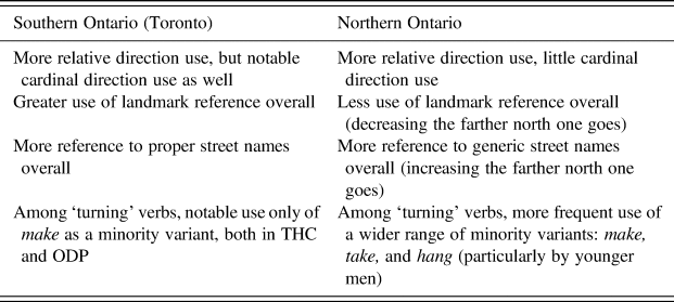
In this article, we have introduced novel data from across Ontario in order to characterise direction-giving across a broad geographic region and to determine what linguistic features differentiate speakers of different social groups. The results are based on a number of salient linguistic variables typical of this highly circumscribed pragmatic context. We used quantitative variationist methods, taking into account the social characteristics of individuals (gender, age) as well as geographic location (region, community) and landscape. The primary goal was to determine which of these factors are relevant in explaining how speakers give directions across Ontario. Analyzing multiple features has been fruitful in mitigating the problem of small token counts in the data by using the corroborating perspectives of similarity and difference across variables as well as the comparative perspective of one of the variables (turning verbs) with the Ontario Dialects Project data. Regional comparisons are summarized in Table 5.
Summary of regional distinctions in direction-giving
With respect to the main aim of this article, these results indicate that direction-giving, when examined as a sociolinguistic variable, can reveal a speaker's social characteristics, including place in terms of locality. There were broad regional differences in the distributions of nearly all variables, suggesting a difference in how speakers from rural Northern Ontario and speakers from the large urban center of Toronto give directions.
5.1 Cognitive economy and geography
Recall that Hölscher et al. (2011) found that directions are generally formulated by the direction-giver in order to facilitate ease of wayfinding for the recipient. Therefore, in order to be maximally useful, the speech act should obey a principle of cognitive economy: directions should be delivered in the most efficient way of communicating wayfinding information. Given this finding, the results of our analysis can aid in connecting social and geographic characteristics with differing rationales of cognitive economy – it seems that what constitutes the most useful set of direction-giving strategies varies by region. Hund and Padgitt's (Reference Hund and Padgitt2010) exposition of direction-giving strategies provided a rubric for us to test in the data. This builds on research on cognitive frames of reference and contrasts two main strategies. Orientation strategies involve reference to objective points and directions (e.g., landmarks, cardinal directions, proper street names, etc.) that remain fixed in their geographic position or title regardless of the particular location of the wayfinder or direction-giver. Route strategies involve reference to points that have no fixed meaning and are relative to the position of an individual speaker (relative directions, generic street names, etc.). In Ontario, relative directions are overall much more frequent than cardinal directions. This high frequency of relative directions overall means that Ontarians are more likely to adopt a first-person, route perspective approach when giving directions than they are to use cardinal directions in reference to points on a mental map. This is consistent with the idea that route strategies are viewed by direction-givers as in general more co-operative, since the direction-giver only has to imagine themself conducting the journey in order to relay directions. Further, route strategies do not require the direction-receiver to have objective familiarity with the area and its cardinal points in order to successfully complete their journey. These results are unsurprising given that the popularity of route strategies for North American direction-givers has been noted in previous research. In Linde and Labov's (Reference Linde and Labov1975) study, nearly all speakers describing the layouts of their apartments took a route perspective approach in beginning from the front door rather than using the orientation strategies involved in describing the apartment from a bird's eye view. Taylor and Tversky (Reference Taylor and Tversky1996) also demonstrated that a sample of Americans asked to describe an environment for listeners were more likely to use route strategies and relative descriptors, and more recently Padgitt and Hund (Reference Padgitt and Hund2012) found that, in experimentation, use of route strategies made for directions that were rated more useful by wayfinders than directions using orientation strategies.
Our results also suggest that the geographic characteristics of the environment impact direction-giving. In Toronto, the rate of cardinal directions far surpassed the rate found in every other locale. Speakers in Toronto may have used a disproportionate number of cardinal directions because the city is so large that they anticipate that a wayfinder may need to refer to a map (for which cardinal directions are useful indicators) to reach an unknown location. In contrast, in the much smaller Northern Ontario communities, direction-givers might presume that individuals are aware of all locations in town, reducing their need to rely on cardinal points or maps to navigate. Taken together, these observations highlight and confirm the conclusion of previous research (e.g., Lawton Reference Lawton2001) claiming that residents of communities with comparatively more grid-like layouts tend to use higher rates of cardinal directions than do residents of less grid-like communities. These findings also suggest that despite a community's spatial orientation or the cardinal orientation of the location to which the direction-giving is focused, certain places, such as large grid-based cities, may predispose speakers to greater use of cardinal directions if only because these are viewed as more co-operative in such places.
Given these findings as well as the perspective afforded by Table 5, it seems that cognitive economy cannot be the sole strategy involved in direction-giving. A number of other results show differentiation by place. Moreover, areal characteristics of a community seem to be highly implicated as well. Consider the street maps for each community, shown in Figure 11. Our main finding is that cardinal directions are a much more frequent choice in direction-giving for speakers in Toronto than for speakers in Northern Ontario generally. Yet when the results for each community are examined separately, we discover anomalies to that generalization. First, cardinal directions were entirely absent from directions given by residents of Kapuskasing. Observation of the layout of Kapuskasing in Figure 11 reveals that it has the least grid-like arrangement of any of the six communities. Second, speakers in Kirkland Lake had a higher rate of cardinal direction usage than in Toronto. As it happens, the two Tim Hortons locations in Kirkland Lake are positioned on opposite sides of the community on the same road: one west of downtown on Government Road, and one east of downtown on Government Road. Most cardinal directions used by speakers in Kirkland Lake made reference to ‘Government Road’, the main roadway dividing the municipality in half latitudinally. Direction-givers referred to Tim Hortons locations by using the east and west cardinal points to differentiate the two. This suggests that the areal layout of Kirkland Lake along a salient east/west orientation with Tim Hortons restaurants placed at either end led to a heightened use of cardinal directions in this community, compared to the other locales. Similarly, the radiating street layout of Kapuskasing led to a heightened use of relative directions in that community, where street layouts did not correspond to simple cardinal points.
Street layouts of communities featured in this analysis (Google Maps 2019)

Another prominent physical feature of a community that undoubtedly contributes to direction-giving is population size. The two most populated places, Toronto and North Bay, have by far the highest rates of proper street name reference and landmark reference. These results suggest that the larger a community is, the more likely one is to use an orientation strategy (e.g., proper street name reference, landmark reference) in direction-giving. Once again, speakers in Kapuskasing stand out, referencing proper street names much more often than do speakers in most other Northern Ontario communities. The same reason as above may apply in explaining this anomaly: Kapuskasing's unique radial streets. Wayfinding in a town with such a layout is much more difficult without referencing proper street names, since cardinal points do not match up with the directionality of its streets. These observations suggest that both population size and street layout of a community are intertwined factors in the way that speakers gave directions.
5.2 Social factors
Region, community, and layout all have an important impact on direction-giving, but what place is there for social factors? We have discovered that in this data, these are less relevant than cognitive strategies and physical geography in determining how directions are given. However, at least some of the variables examined in the THC exhibit social and/or regional differences. Importantly, these findings offer evidence to refute previous claims on a possible gender bias in direction-giving with respect to direction type. As summarized earlier, a pervasive claim in the existing literature (e.g., Ward et al. Reference Ward, Newcombe and Overton1986, Pearson and Lee Reference Pearson and Samuel Lee1992, Lawton Reference Lawton2001, Napoleon Reference Napoleon2007) is that men prefer orientation strategies in direction-giving and women prefer route strategies. In Ontario, use of cardinal directions (an orientation strategy) vs. relative directions (a route strategy) were only marginally distinguished by the gender or age of the speaker. In fact, in Toronto, men preferred relative directions (with younger men having the highest rates of usage) while women displayed a high frequency of use of cardinal directions – the opposite finding from previous claims. In contrast, in Northern Ontario, men (again, particularly younger men) preferred cardinal directions and used fewer relative directions than did any other group of speakers. This result shows that rather than being a speech act governed solely by cognitive economy or pragmatics, direction-giving embodies linguistic variation and change just as any other register of the vernacular. The same familiar principles apply – that is, men use more vernacular features, as per Labov's Second Principle of linguistic change (Labov Reference Labov2001: 274). Only through examination of social factors such as age, gender, and place along with direction type is it possible to disentangle the many linguistic choices in direction-giving strategies.
5.3 Lexis
Lexical variation among turning verbs showed evidence of regional distinction and possibly linguistic change in progress. The turning verb hang was used exclusively by men, and particularly by younger men in Northern Ontario. These differences may simply be the result of the fact that we sampled a minor sub-register of the varieties under investigation and are simply tapping into extant dialect differences. Indeed, the lack of a gender difference for most vernacular variants found in this study corroborates the findings found in other studies of Ontario dialects (e.g., Jankowski and Tagliamonte Reference Jankowski and Tagliamonte2019, and Jankowski and Tagliamonte, Reference Jankowski, Tagliamonte, Ziegler, Edler, Kleczkowski and Oberdorferto appear) and suggests that more studies of Ontario communities may expose additional dialect differences. However, more in-depth study of these specific variables with respect to local affiliation is necessary in order to fully understand these results.
6. Conclusions, implications, and future research
This study of social and geographic patterns of direction-giving in Ontario highlights the value of studying direction-giving from multiple perspectives. Speakers throughout Ontario exhibited a preference for route strategies as opposed to orientation strategies, suggesting that there may be an overall tendency toward a relative frame of reference for Canadian English speakers in Ontario and perhaps more generally in the country. Place in terms of population size and community was implicated in the distributions of multiple variables, with findings demonstrating, among other things, that speakers in larger and more grid-like communities use more cardinal directions than do speakers in smaller and less grid-like places and that speakers from Northern Ontario communities exhibit linguistic direction-giving behaviours distinct from speakers in the Southern Ontario city of Toronto.
While this study is limited by the nature and extent of the data, the findings are provocative in a number of ways. They suggest that direction-giving is a bona fide site for sociolinguistic and dialectal variation and that it comprises a wide array of linguistic variables that are ripe for further study (e.g., direction type, landmark usage, street name reference, etc.). We hope that this study encourages researchers to document the direction-giving features of other locales and community types to facilitate broader comparison. Finally, this research shows that Northern Ontario is a distinct linguistic region compared to the large urban center of Toronto, adding to the increasing body of research on Canadian dialects of English.


