


Introduction
In the years on either side of the new millennium, attacks on significant Middle Eastern cultural heritage increased dramatically in number, with the intentional destruction of sites, monuments and even entire landscapes. Simultaneously, the impact of such attacks has become progressively more severe and spectacular with the increasing power of weapons and the greater influence of the media (Matthiae Reference Matthiae2015). The fundamental reason for this escalation is that cultural heritage, archaeology, monuments and architecture in general are not simply material objects; they are also symbols that have a transcendent character in terms of human history, customs, identity and diversity (Bevan Reference Bevan2016); such symbolic significance is increasingly at odds with some political and religious ideologies.
In Iraq, there have been intensified episodes of looting, for example at the Baghdad Museum during the Second Gulf War in 2003 (Fales Reference Fales2006). After the establishment of the modern Caliphate in the region in June 2014, a deliberate and systematic programme of vandalism razed countless religious and cultural sites. An Islamic State of Iraq and Syria (ISIS) video prominently featured the smashing of statues and artefacts at the Mosul Museum and the destruction of anthropomorphic masks at Hatra, along with the demolition of monuments at archaeological sites, including Nimrud and Nineveh. The reasons for such brutality have been addressed by many scholars from a variety of perspectives, and a lively debate continues (e.g. Harmanşah Reference Harmanşah2015; Smith et al. Reference Smith, Burke, Leiuen and Jackson2016; Jones Reference Jones2018; Shahab & Isakhan Reference Shahab and Isakhan2018). Two prominent aspects of the aims and methods of ISIS, however, are the erasure of places of worship of the monotheistic religions, particularly Islamic mosques, shrines and tombs, and the destruction of pre-Islamic art and archaeology (Melčák & Beránek Reference Melčák and Beránek2017).
In December 2014, soon after the military occupation by ISIS, a joint Iraqi-Italian project involving the present authors started recording, evaluating and monitoring the damage and destruction inflicted on a series of sensitive archaeological contexts in northern Iraq, using satellite-based remote sensing (Bianchi et al. Reference Bianchi, Petit and Bonaccossi2017). The current article presents work undertaken on Nineveh, best known as the imperial capital of the Neo-Assyrian Empire under King Sennacherib (705–681 BC), who remodelled the city and its defences and built a royal citadel there; today the site lies within the modern city of Mosul. Our project formed part of wider Iraqi and international efforts to observe and document such damage; other well-informed reports published during the course of our work appeared on the American School of Oriental Research (ASOR) website between 2014 and 2018 (see Cultural Heritage Initiatives 2016), the Oriental Institute in Prague (2021) website in 2021 and the Gates of Nineveh website (Jones Reference Jones2020).
Between 2014 and 2020, we completed two years of remote monitoring, followed by a ground-based survey of archaeologically sensitive sites and monuments at Nineveh. An Iraqi-Italian team also carried out a systematic inspection of the entire circuit of the great defensive walls using ground-based survey and drone-based observation and recording, along with visits to other key locations within the vast Neo-Assyrian compound. The results of all this work have been combined to generate a new topographic map of the ancient city and its defensive and hydraulic systems, as well as an inventory of damage and destruction of varying severity at hundreds of individual locations. The datasets, drone Orthophotos, Digital Surface Models (DSMs) and interpretation files of archaeological damage are available, open access, on Zenodo (https://zenodo.org/record/5731520#.Ye8Pri9aZqs).
Satellite-based assessment of ISIS-inflicted damage
The first phase of the initiative, from December 2014 to November 2016, produced a geo-database of archaeological and cultural heritage sites in the five Iraqi governorates once entirely or partly under the control of ISIS (Figure 1). An assessment and monitoring of visible damage across time in selected sample areas was also made by matching and analysing high-resolution satellite imagery taken before and after the ISIS occupation (Hritz Reference Hritz2014).
Iraqi governorates and selected archaeological sites, listed in collaboration with the Iraqi authorities and analysed by monitoring site transformations through remote sensing (sites listed in Table 1) (figure by S. Campana).
List of the main cities and sites under investigation in northern Iraq.

Satellite image coverage extended to approximately 1380km2, within which 997 areas of particular archaeological interest were identified and mapped. Remote-sensing datasets and related GIS and site records were shared to serve as the core of an updated Iraqi Archaeological Map, implemented by the Iraqi State Board of Antiquities and Heritage (SBAH). In addition to the remote-sensing datasets, the summary of the results presented here also draws on information from both local and international sources (Bianchi et al. Reference Bianchi, Petit and Bonaccossi2017; see also Table 1).
Contrary to expectations shaped by media coverage, our survey revealed a low incidence of sites that appeared to have been looted for the acquisition and smuggling of antiquities, reflecting the results of other assessments for northern Iraq more generally (e.g. Casana & Laugier Reference Casana and Laugier2017). The worst examples of destruction, dictated by propaganda motives, were concentrated in urban areas. Mosul was the prime target of this activity and various assessments have focused on this city (e.g. Melčák & Beránek Reference Melčák and Beránek2017; Nováček et al. Reference Nováček, Melčák, Starková and Beránek2017; Isakhan & Meskell Reference Isakhan and Meskell2019). The ancient site of Nineveh, located within eastern Mosul, has received less detailed attention, and hence this present article concentrates on damage and destruction of the great Neo-Assyrian capital.
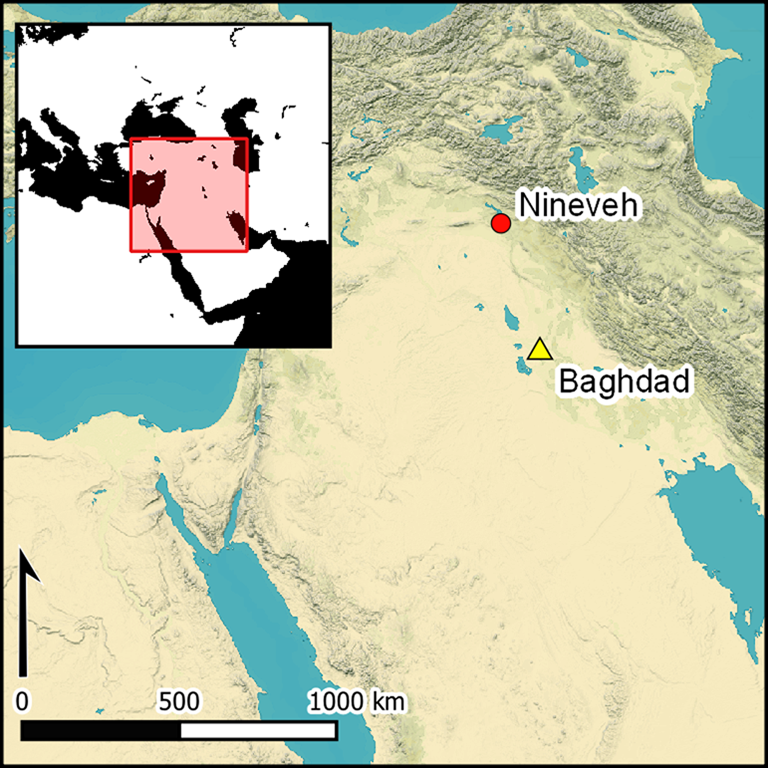
Nineveh was built on the eastern banks of the Tigris River, its southern parts traversed from west to east by the tributary river Khosr. Its extensive urban area of about 750ha, which is surrounded by an imposing system of defensive walls some 12km in length, is dominated by two prominent mounds: Tell Kuyunjik, which covers over 40ha and rises approximately 30m above the surrounding plain, and the smaller Tell Nebi Yunus (Figure 2).
Satellite image of Nineveh (WorldView-2 imagery acquired 15 November 2013) (left) and analysis of pre-ISIS damage and destruction (right) (figure by S. Campana).

Continuously occupied from the seventh millennium BC until well into the first millennium AD, Nineveh achieved great status when it became the imperial capital of the Neo-Assyrian Empire under King Sennacherib (705–681 BC). The king famously promoted a colossal project of urban renovation and expansion, including the diversion of the Tigris and Khosr Rivers into artificial channels, the construction in mudbrick and dressed stone of a double city wall with 18 monumental gates, the building of a ceremonial avenue paved in stone, and the construction of a new palatial residence as a royal citadel on the mound of Kuyunjik, which Sennacherib himself called the ‘Palace without Rival’ (known in the archaeological literature as the South-Western Palace; Nadali Reference Nadali2015). Today, Nineveh is entirely surrounded by the city of Mosul and the central part of the compound (Figures 2 & 3) is incorporated into the fabric of the modern city. The pressure of urban development on the archaeological area is therefore great.
Satellite imagery
Our satellite imagery analysis (Bianchi et al. Reference Bianchi, Petit and Bonaccossi2017) was based on the WorldView archive collections, comparing panchromatic and multispectral images captured on 15 November 2013 before the occupation by ISIS (WorldView-2) with images taken on 29 August 2015 (WorldView-2) and in November 2016 (WorldView-3). It is important here to emphasise the intrinsic ambiguity of the concept of ‘damage’ in relation to its identification via remote sensing, and the need to measure it appropriately (Cunliffe Reference Cunliffe2014a). Most damage assessments in the Fertile Crescent and beyond have studied large landscapes (usually a state or several states, or even larger regions, such as, for instance, by the Endangered Archaeology in the Middle East and North Africa (EAMENA) project; Rayne et al. Reference Rayne2017) using a procedure based on the presence or absence of anthropogenic traces. For the latter, scholars have developed various methods of damage analysis (e.g. Cunliffe Reference Cunliffe2014b; Casana & Laugier Reference Casana and Laugier2017; Danti et al. Reference Danti, Branting and Penacho2017; Rayne et al. Reference Rayne2017; Marchetti et al. Reference Marchetti2019; Zaina Reference Zaina2019; Angiuli et al. Reference Angiuli2020). The city of Nineveh, however, takes the form of a single, large, continuous archaeological site, within which almost any location could be considered of potential archaeological interest; any intrusive activity might therefore damage unknown archaeological stratigraphy in terms of depth, extent and intrinsic character.
From the outset, our damage assessment was conceived as an appraisal of what happened at Nineveh during the ISIS occupation. Our method was therefore based initially on the systematic horizontal mapping of any damage detectable on the 2013 satellite imagery, which defined the situation prior to the ISIS occupation. The relatively limited resolution of the satellite imagery—and the intentionally rapid strategy of analysis—did not permit the mapping of ‘vertical’ damage. Assessment of a few sample locations, carefully selected later in the process, confirmed that drone-based, low-level photogrammetry combined with observation in the field would have allowed this to be achieved systematically, had time permitted. Nevertheless, our team attempted to record the scale of the damage according to a deductive procedure based on the principles of aerial photographic interpretation, by reducing the range of the observed damage to the categories of ‘minor’, ‘moderate’, ‘severe’ and ‘not identifiable’. Each subsequent set of images (from 2015, 2016 and from drone-based surveys in 2018 and 2020) was then compared with all the previous data to create a layer of mapping that records only that damage clearly inflicted during the ISIS occupation.
In 2013, the area within the city walls already showed evidence of serious damage. The full extent of the ancient city was calculated to be approximately 1067ha, and the 2013 imagery shows surface damage of various types across some 375ha—around 35 per cent of the city. The most serious losses were due predominantly to the urbanisation of the central part of the city and to bulldozing or other forms of levelling for a variety of purposes within the peripheral areas. The threat to the preservation of Nineveh caused by its proximity to the expanding suburbs of Mosul had already been highlighted in previous decades when the SBAH, local authorities and international bodies initiated projects to oppose, or at least partially arrest, this trend. Account must also be taken of damage associated with a dense internal network of unpaved roads and modern agriculture, the impact of which—though difficult to quantify—is of central importance for the first metre of stratigraphy across most of the non-urbanised areas of the site, with the exception of Tell Kuyunjik and of the embankment that still surrounds much of the city walls (Figure 2).
Under the ISIS occupation, known damage to the city of Nineveh includes that caused by the infamous bombing of the religious buildings on Tell Nebi Yunus in August 2014, bulldozing in 2015, the defacement of parts of the city walls and gates, and attacks on the colossal sculptures at the Nergal Gate and the interior of Sennacherib's palace in 2015. The later satellite imagery (2015 and 2016), however, demonstrates that the worst damage to the integrity of the site, and hence its future cultural appreciation, was from construction projects already completed or still in progress by the end of the ISIS occupation—principally the building of a two-lane highway and the clearance of extensive areas for private housing (Figure 3).
Categories of damage detected and dated by comparing the results of satellite imagery from 2015 and the latter part of 2016 (figure by S. Campana).

The impact of surface disturbance (or ‘land consumption’) during the two years of ISIS occupation amounted to a total of 85ha, of which 3.5ha (4 per cent) is related to vandalism and 78ha (91 per cent) to new settlement or infrastructure schemes. These activities were facilitated by the complete abrogation of the heritage protection acts during the ISIS administration, both at Nineveh and elsewhere (Casana & Laugier Reference Casana and Laugier2017). The relatively limited amount of deliberate ideological destruction by ISIS at Nineveh should nevertheless not be underestimated, as these assaults were directed predominantly at specific monuments and features of outstanding cultural and archaeological value; the destruction of such features across 3.5ha of the city represents a loss of enormous significance. Finally, 11 enormous rectangular anomalies, orientated roughly east–west and measuring between 50 and 110m in length, 15 and 50m in width and up to 6.5–7m in depth, were identified in the satellite data in the northern part of the city (Figure 4: right). Despite much speculation by our team, the correct interpretation of these features was not established until they were later examined during ground-based survey, as described below.
Left) Map of damage identified by drone survey, visualised by categories; top/bottom right) detail (A–K) of the ISIS excavation of underground silos/granaries (figure by S. Campana).

A common form of damage recorded in conflict situations is looting for monetary gain (Cunliffe Reference Cunliffe2014a; Casana & Laugier Reference Casana and Laugier2017). Illegal excavations of this kind can usually be recognised on satellite images by the presence within known archaeological sites of large numbers of holes, the vast majority appearing as dark, sub-circular areas (1–3m across) with a surrounding ring probably representing upcast material. The size, shape and close grouping of such anomalies mark out patterns of organised looting. Rather surprisingly, there is no such evidence for looting at Nineveh on any of the satellite imagery that we analysed, although a few ‘tunnels’ potentially associated with these activities were identified by ASOR's Cultural Heritage Initiatives (2016: 84).
Ground-based assessment
In November 2018, on-site fieldwork, which formed part of a training course for SBAH personnel, sought evidence of illegal ground disturbance complementing the war-related damage previously detected by remote sensing. The course provided instruction in basic theoretical and technical tools for drone-based photogrammetry, and in systems for documenting the archaeological heritage in the sensitive post-ISIS conditions of Mosul. Because of the enormous area involved, work was restricted to the inner compound of Nineveh, using drone photography and targeted ground-based survey based on the initial interpretation of the satellite imagery. Direct observation on the ground was essential to confirm or revise our preliminary interpretations of the satellite data.
Drone-based survey
Low-level aerial survey by drone was chosen for its capacity to record the entire urban layout of Nineveh at high speed, extremely high resolution, and low cost; we used a consumer-quality drone: a DJI Phantom 4 Pro. Much of the survey was undertaken in November 2018, while Tell Nebi Yunus and the southern and largely agricultural northern parts of the compound were covered in February 2020. Data were collected over five days for the entire urban area, including the surviving part of the eastern external fortification system, covering a total area of approximately 812ha (Figure 5). Processing allowed the creation of a detailed DSM of the city's topography, capable of producing high-resolution orthomosaics to aid detailed inspection and monitoring of the condition of each individual context.
Left: Digital Surface Model processed from drone-based photogrammetry (yellow tones for higher land, green for lower land); right: orthophoto map processed from the photogrammetric images (figure by S. Campana).

The improvement in ground resolution for the drone (approximately 20mm) compared with that of the satellite imagery (0.5m for Worldview-2 and 0.3m for Worldview-3) was substantial and resulted in a greater ability to identify and characterise the damage recorded on the satellite imagery. Moreover, the high-resolution DSM significantly increased our capacity to interpret the evidence on site with greater confidence. Data analysis was carried out using both the DSM and the orthomosaics from the drone photography.
Each instance of damage or destruction was mapped in GIS using digital polygons associated with a table of attributes that characterised the features concerned. These included the type and degree of damage, reliability of interpretation, field observations and extent in square metres. Analysis of the orthophoto map and DSM identified further instances of damage, increasing the total affected area to approximately 90ha, or 12 per cent of the walled city. As expected, the distribution of the various types of damage proved more complex than initially suggested by the satellite imagery. The categories identified included levelling, new construction work, neglect (e.g. piles of debris, soil and/or waste), entrenchment (for military purposes), bombing, underground silos (see below), vandalism, erosion and generic excavation.
Figure 6 shows the distribution and quantitative correlation between the satellite evidence and that acquired by drone. Alongside vandalism of the city walls, gates and Sennacherib's palace (Figure 7j), serious deterioration of the archaeological area caused by urban development, neglect and damage directly related to the conflict is evident.
Types of damage identified by satellite (blue) and by drone survey (green), measured in hectares (figure by S. Campana).

Representative examples of the main types of damage, shown in each case as drone-based air photography (left) and Digital Surface Model (right): a) new constructions; b) bombing; c) new constructions; d) entrenchment; e) erosion; f) excavation (marked by arrows); g) levelling; h) underground silo; i) neglect (examples marked by arrows); j) vandalism (marked by arrows) (figure by S. Campana).

Urban development over the past century has profoundly affected conservation efforts at Nineveh and, in places, has obliterated archaeological deposits in the central part of the ancient city. Before the occupation by ISIS, however, both the northern and southern parts were still barely inhabited, remaining mostly undeveloped. Analysis of the satellite images now reveals numerous new buildings and related activities covering an area of approximately 78ha; to this figure, we must now add a further 50ha of damage and destruction mapped by the drone-based survey, making a total of 128ha within the city walls. Thus, over the last five years, damage and destruction have affected as much as 17 per cent of the archaeological area—a depressing rate of attrition that, if it were to continue unabated, would lead to the total destruction of the city's archaeological resources within 20 years. The time span of the images analysed in the present study make the reality of the unrelenting process of urbanisation clear: it starts with the mechanical levelling of the land, followed by the creation of boundaries around building plots of a similar size, and ends with the gradual construction of individual housing units.
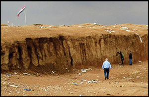
Among the most striking and irreparable instances of damage encountered during the survey are a series of ‘underground silos’. These structures correspond to the large, distinctive anomalies identified on the satellite imagery that we were initially unable to assign to a specific interpretative category. Drone reconnaissance, site inspection and testimony from local SBAH officials eventually identified these anomalies as huge, rectangular trenches dug by ISIS and used to store grain reserves and other materials (Figures 4 & 7–8). The total area affected by these silos was 1.2ha; in some cases, they reached a depth of 8m, irreversibly compromising the archaeological stratigraphy. Based on the photogrammetric surveys, the construction of the silos removed an estimated 50 000m3 of subsurface deposits. Further details are provided in the section below detailing the ground-based survey.
Nineveh, November 2018: top) view of Trench B, one of the so-called ‘granaries’ excavated by ISIS, looking west (note the accumulation of various types of rubbish); centre and bottom) orthophotomosaic of the west section, demonstrating the complexity of the archaeological stratigraphy removed by the creation of the granaries (photographs by the authors; figure by S. Campana).

Neglect represents another serious problem, revealed in particular by the scattering of enormous quantities of debris and waste in open-air rubbish dumps, covering 33.2ha in total. In these cases, however, the damage to the underlying archaeological deposits is unlikely to be serious; observations on the ground showed that there was no apparent disturbance to the original ground surface at these locations; instead, accumulations of earth and building materials (mostly rubble from the devasted city of Mosul) conceal the archaeological deposits and degrade the landscape.
A further aspect of deterioration through neglect—visible clearly only on the drone imagery—is surface erosion, which has become a serious problem along the entire length of the embankment of the eastern flank of the city walls. An attempt to measure this phenomenon by mapping the most evident erosion channels suggests that these affected at least 3ha of the embankment's surface (the embankment itself covers approximately 40ha).
Damage from military action, caused both by ISIS and during the subsequent liberation of Mosul, is mainly attributable to bombing and to the digging of entrenchments for the installation of anti-aircraft guns and other military equipment. Although the extent of the damage is limited to approximately 1ha, in most cases it affects the embankment and therefore further increases the erosion and deterioration of this important feature of the city.
Ground-based survey
Guided by the drone-based imagery, the entire circuit of the city walls was examined on the ground, proceeding clockwise in teams of four or five persons, moving along the top, inner and outer slopes of the walls. Every anomaly previously identified on the remote-sensing data was assessed and mapped on the ground.
Within the city walls, the most striking instances of damage were the 11 huge excavations identified by local people as ‘granaries’ (‘underground silos’ in the drone-based interpretation layer). Consistently orientated approximately west–east, they were all located within the northern sector of the ancient city, in three groups, with a single outlier further to the south-west (labelled A–C, D–H, I–J and K in Figure 4). Ground inspection showed that they had originally been covered by plastic sheeting and probably a layer of soil. In building these structures, ISIS has irrevocably destroyed a large portion of the unexcavated city, down to the natural geological substratum. Figure 8 illustrates the extent of the destruction, which removed an estimated 50 000m3 of stratified archaeological deposits, along with an incalculable quantity of ancient artefacts, the present whereabouts of which remain unknown.
Trenches A, B and C each measure approximately 80–100m in length and 30m in width. Two complete sections, documented by photogrammetry, demonstrate that a densely built-up area was destroyed, including a monumental, approximately 4.5m-wide mudbrick wall running north–south between Trenches B and C. In addition to mudbrick structures, the section of Trench B revealed brick-paved floors, pits, two wells, and massive fills containing pottery. Scattered on the disturbed surface, among recent debris, were Palaeolithic stone tools, numerous Neo-Assyrian and possibly later pottery sherds, fragments of Assyrian stone vessels, grinding stones and a large fragment of a gypsum doorsill.
Trenches D–H were slightly smaller and were cut into the inner slope of the main mudbrick wall of Sennacherib's defences. Here too, the destruction of archaeological deposits was substantial, especially in Trenches D and E, where, at the top, the sections showed thick lenses of flat, angular limestone flakes—probably from dressing blocks of stone for the outer face of the city wall. Two sections were recorded by photogrammetry; that for Trench H shows evidence of a substantial mudbrick construction.
Trenches I and J were dug in another important archaeological area approximately 200m north-west of Trenches D–H. These trenches destroyed a low, wide mound, exposing mudbrick walls, fired bricks set in bitumen, terracotta pipe fragments, gypsum slabs (perhaps doorsills), complete vessels and other artefacts. The architectural elements seem to be attributable to a large-scale conflagration, possibly linked to the destruction of the city in 612 BC (Gadd Reference Gadd1923; but see Taylor et al. Reference Taylor2010). Before this event, the local settlement seems to have developed in at least two consecutive phases of construction.
Trench K was an isolated excavation located north of the bend of the Khosr River and affecting an area of intensive settlement and building activity, with architectural features similar to those described above—in this case, including three or four buildings. Visible in the northern section, 0.5m below the surface, was a 20m length of paving made from large, fired bricks—perhaps part of a courtyard.
Finally, features identified by ASOR as tunnels, possibly intended for looting, were inspected. At Tell Kuyunjik, the presence of a dense network of recent tunnels (Figure 9) was confirmed. These were probably excavated by ISIS to facilitate (and conceal) the movement of materials and people. There was, however, no evidence to support any relationship with looting. Nevertheless, similar tunnels across the whole of Nineveh deserve further investigation and mapping; indeed, the use of tunnels has a long history in Mosul, at least in Nebi Yunus and Kuyunjik, where, since Layard's excavations in the mid-nineteenth century, this has been an established method of bypassing the massive Parthian and Sasanian occupation levels and speeding up the exploration of the Neo-Assyrian remains (Rassam Reference Rassam1897).
Tunnels surveyed at Tell Kuyunjik in November 2018 (photographs by the authors; figure by S. Campana).

Discussion
Our archaeological impact assessment of ISIS-inflicted damage at Nineveh is based primarily on satellite images and aerial photographs showing two major types of damage: that designed to destroy or erase highly visible and archaeologically sensitive parts of the city or compromise structures and infrastructure serving the interests of mass tourism, and that caused by neglect or war, which appears to have had a much lower impact. The intentional damage was clearly aimed at the obliteration of pre-Islamic structures with a strongly evocative, monumental or iconic character—in particular the city walls, the entrance gates and Sennacherib's ‘Palace without Rival’. There was also serious damage to local religious buildings, notably Nebi Yunus, along with many other structures within the citadel of Mosul. These deliberate acts of destruction have seriously mutilated the site, compromising its identity and power to communicate with future generations, especially the general public who may be less accustomed than specialists to imagining historical scenarios in the absence of their monumental elements. Intentional damage of this kind is therefore extremely serious and, in many cases, irreversible.
A further category of damage is associated with structures and infrastructure built by ISIS without considering the archaeological implications. The massive underground ‘silos’ were all created between September 2015 and November 2016, removing vast quantities of soil and compromising a chronological sequence extending from the Palaeolithic to the destruction of the city in 612 BC. In quantitative terms, this clearly represents the most serious instance of archaeologically damaging ‘development’ recorded by the project team.
While accepting that the accumulation of debris inside the city and immediately outside the great embankment is a long-term phenomenon that pre-dates the ISIS occupation, the survey team could not establish where the soil (and finds) removed from the silos was eventually deposited. Analysis of the satellite and aerial imagery does not reveal any likely deposits in the immediate surroundings. Since the creation of the silos involved the wholesale removal of substantial archaeological deposits, it is difficult to exclude the possibility of large-scale looting at the time that they were built.
Further surface losses within the archaeological area are attested by the expansion of built-up areas and the development of new ones. This is clearly the result of an attempt by ISIS at orderly and consistent planning within the pre-existing urban layout. In addition, between 2015 and 2016, a two-lane highway, approximately 2km long, was constructed across the southern part of the city. All these activities have had a significant and highly destructive impact on the survival and conservation of stratified archaeological deposits within the ancient city, which is further exacerbated by the absence of any documentation or other attention to the archaeological evidence.
The restoration of control by the national authority in July 2017 re-established the role of the SBAH, which has resumed active surveillance, monitoring the conservation of Nineveh with the greatest possible efficiency. The drone- and ground-based surveys of 2018 and 2020 have made it possible to observe and record in detail what happened over the previous two years, clarifying the extent and variety of damage inflicted during the ISIS occupation. Land consumption, particularly for new housing and related facilities, has continued at a rapid rate following the ISIS occupation, albeit now under the supervision of the SBAH. Other evidence of neglect and degradation attest a growing city in serious difficulty amid the problems and uncertainties of resuming civilian life. Particularly concerning is the disposal of waste and wartime rubble both inside the city and immediately beyond the embankment, making use of every available surface depression and cavity, including those left by the ISIS ‘silos’.
Conclusion
As part of international efforts to monitor and assess the impact of damage inflicted by ISIS across northern Iraq, and to assist in the resumption of cultural heritage protection measures, we have undertaken a project combining remote and ground-based surveys of the Assyrian city of Nineveh. The results demonstrate that, during the two-year occupation, strategic parts of the site were deliberately targeted for destruction, but a much larger area, covering tens of hectares, was destroyed by construction work and rubbish dumping. The site had already been affected by development and erosion prior to the ISIS occupation—and these processes continue following the end of the occupation—but the unchecked construction and dumping activity under ISIS has inflicted particularly extensive damage to the site. Now that government control has been re-established, there is an urgent need for a master plan for the conservation of Nineveh, to avoid its transformation into an open and polluted landfill site, and to prevent its absorption into the expanding city of Mosul. Such a plan should set out immediate actions for reclamation and restoration, starting with the careful filling of the numerous holes and trenches scattered around the site and continuing with a long-term programme of restoration, maintenance and enhancement of the city's remaining archaeological and cultural assets. As far as possible, Nineveh should be returned to its former identity as a communal space, within which the enduring and extraordinary history of the ancient city can be appreciated and celebrated, while supporting the daily livelihoods of its long-suffering local communities.
Acknowledgements
The work presented here owes thanks to international and Italian agencies, associations and academic institutions not only for financial support (see funding statement) but also for help in many other respects. Particular thanks are offered to the State Board of Antiquities and Heritage (Baghdad and Nineveh Office) in Iraq for scientific collaboration, constant support and valuable advice. We would like to thank the peer reviewers for their thoughtful comments and efforts towards improving our manuscript. Sections 1 and 2 were written by SC, SB, MV, AB; section 3.1 by SC and MS; section 3.2 by SB and MV; and sections 4 and 5 by SC, SB and MV. Open access datasets published on Zenodo: https://zenodo.org/record/5731520#.Ye8Pri9aZqs.
Funding statement
This research benefited from the financial support of the Ministry of Cultural Heritage (MIBAC) and Ministry of Foreign Affairs and International Cooperation (MAECI) in Italy, the International Alliance for the Protection of Heritage in Conflict Areas (ALIPH), the International Association for Mediterranean and Oriental Studies (ISMEO) and the Universities of Siena and Padua. The generosity and support of these institutions are greatly appreciated.


 Open access