




Introduction
The Balkans is a key region for understanding the emergence and development of early copper-ore mining and metallurgy in Eurasia (e.g. Renfrew Reference Renfrew1969; Jovanović & Ottaway Reference Jovanović and Ottaway1976; Pernicka et al. Reference Pernicka, Begemann and Schmitt-Strecker1993; Roberts et al. Reference Roberts, Thornton and Pigott2009; Radivojević et al. Reference Radivojević, Rehren, Pernicka, Šljivar, Brauns and Borić2010a, Reference Radivojević, Roberts, Marić, Kuzmanović-Cvetković and Rehren2021a; Antonović Reference Antonović2014). Local copper ores were exploited by at least the sixth millennium BC in the mining areas of Rudna Glava, Serbia, and the late fifth millennium BC in Ai Bunar, Bulgaria (Jovanović Reference Jovanović1971; Chernykh Reference Chernykh1978; Radivojević & Kuzmanović-Cvetković Reference Radivojević and Kuzmanović-Cvetković2014; Krauss et al. Reference Krauss, Pernicka, Kunze, Dimitrov and Leshtakov2021). With almost five tonnes of copper implements excavated from fifth-millennium BC contexts in the Balkans (Pernicka et al. Reference Pernicka, Begemann, Schmitt-Strecker, Todorova and Kuleff1997), the scale of extraction of copper ore must, by implication, have been far higher, as these artefacts are only a fraction of the circulating copper metal from that period. In the early fourth millennium BC, however, metal production and consumption is widely understood to have completely collapsed in the Balkans and shifted towards central Europe (Höppner et al. Reference Höppner, Bartelheim, Huijsmans, Krauss, Martinek, Pernicka and Schwab.2005; Radivojević & Grujić Reference Radivojević and Grujić2018; Grujić & Radivojević Reference Grujić, Radivojević, Brughmans, Mills, Munson and Peeples2023), apparently echoing a major societal catastrophe (Weninger et al. Reference Weninger2009). Alternative interpretations suggest instead that fewer metal artefacts entered the archaeological record in this period due to changes in depositional practices (e.g. Taylor Reference Taylor, Young, Pollard, Budd and Ixer1999), but direct evidence of primary metal production has also been lacking. Rudna Glava was no longer worked in the fourth millennium BC, and its ore has not yet been identified in metal artefacts produced at the time (Pernicka et al. Reference Pernicka, Begemann and Schmitt-Strecker1993; Kunze & Pernicka Reference Kunze, Pernicka, Krauss, Pernicka, Kunze, Dimitrov and Leshtakov2021; Radivojević et al. Reference Radivojević, Rehren, Pernicka, Radivojević, Roberts, Marić, Kuzmanović-Cvetković and Rehren2021b). Similarly, activity at Ai Bunar does not seem to last into the beginning of the fourth millennium BC (Pernicka et al. Reference Pernicka, Begemann, Schmitt-Strecker, Todorova and Kuleff1997). On the other hand, Majdanpek in eastern Serbia seems to have served as a prolific copper-ore source for metal implements from the early fourth millennium BC, both in the central Balkans and the Alps (Höppner et al. Reference Höppner, Bartelheim, Huijsmans, Krauss, Martinek, Pernicka and Schwab.2005; Frank & Pernicka Reference Frank, Pernicka, Midgley and Sanders2012), although traces of ancient mining activities here are being destroyed by modern exploitation.
From a broader European perspective, the earliest metal objects from adjacent regions further west, such as the Central Mediterranean (Dolfini Reference Dolfini, Roberts and Thornton2014) and Central and Northern Europe (Rosenstock et al. Reference Rosenstock, Scharl, Schier, Bartelheim, Horejs and Krauss2016; Scharl Reference Scharl2016; Nørgaard et al. Reference Nørgaard, Pernicka and Vandkilde2021), date from the turn of the fifth to the fourth millennium BC, when evidence for copper mining west of the Balkans also becomes apparent (Schauer et al. Reference Schauer, Shennan, Bevan, Colledge, Edinborough, Kerig and Parker Pearson2021). Despite this westward transmission of copper production in the fourth millennium BC and its apparent cessation in the Balkans, the chemical fingerprint of Balkan ores can still be identified in copper implements across Europe—from as far afield as the northern European plain and southern Scandinavia (Nørgaard et al. Reference Nørgaard, Pernicka and Vandkilde2021; Brozio et al. Reference Brozio2023; Kowalski et al. Reference Kowalski2024)—during the fourth millennium BC (Frank & Pernicka Reference Frank, Pernicka, Midgley and Sanders2012). What has been missing from the debate is a contemporaneous copper mine in the Balkans, a gap that can now be closed by new research on the site of Curak in the Serbian Jarmovac Valley (Figure 1).
Map of the Jarmovac Valley near Priboj showing the locations of the sites mentioned in the text and the find numbers of the ores sampled for analysis (compare with Table 3, Fd-No.); ore occurrences according to the Geological map of Priboj area, Socialist Federal Republic of Yugoslavia survey (1972) (base map: ArcGIS; figure by J. Pendić & P. Thomas, Deutsches Bergbau-Museum Bochum).

The Jarmovac Valley
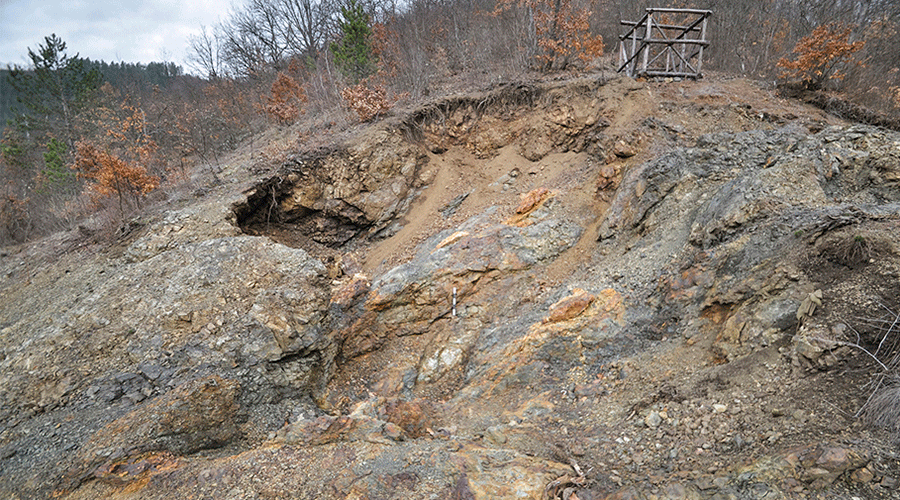
Old mining works in the Jarmovac Valley close to Priboj on Lim, south-west Serbia, were first reported by Oliver Davies in 1937. He published a hammer stone and spoke of “a much ruined ancient opencast” and “below a recent shaft, … the weathered tip of a much older shaft” (Davies Reference Davies1937: 2), both close to one another on the valley floor. Today, the identification of the structures he described is challenging, but it is likely that they relate to the mining sites of Majdan and Popovina (Figures 1 & 2). Further work on ancient mining in the area restarted only in 2003, when Savo Derikonjić (Priboj on Lim Homeland Museum) carried out excavations at the site of Majdan. These revealed that the visible structure reported by Davies (Reference Davies1938) did not belong to an open cast mine, but to an as yet undated gallery and shaft system with at least two phases of activity (Derikonjić Reference Derikonjić2010: 6, 24). Excavations in 2007 revealed medieval-period shafts with associated ceramics at Curak. Downhill, an open cast mine was discovered and identified as prehistoric based on hammer stones and diagnostic ceramics (Figures 3 & 4).
The sites of Majdan (A) and Popovina (B) (photographs by P. Thomas, Deutsches Bergbau-Museum Bochum).

A) The open cast mine of Curak in spring 2013, view from the south. In the background, under the wooden scaffold, is one of the earlier excavated shafts. B) First profile of the Western Drift in the open cast of Curak in spring 2013 with a hammer stone in situ (see inset for detail). C) The bottom of the open cast of Curak with remnants of the quartz layer interlaced with iron hydroxide (below and above the scale bar) and specks of malachite to the left of it (photographs by P. Thomas, Deutsches Bergbau-Museum Bochum).

Digital Elevation Model of the open cast mine of Curak with the two excavated shafts in the north and in the east of it (model based on photogrammetry; figure by J. Pendić).

In 2013, a team of archaeologists from Serbia, the UK and Germany surveyed the Jarmovac Valley for prehistoric copper-mining sites. Despite identifying various mining structures and copper-rich outcrops (Figure 1), no further evidence of prehistoric copper-ore exploitation or metal production was found, apart from Curak, which was initially invisible due to sediment deposition.
In the Western Drift of the Curak mine (a near horizontal anthropogenic passage underground), original sediment infill remained in situ, posing a safety hazard. An initial profile excavated in March 2013 revealed two metres of undisturbed mining residues and erosion materials, including a grooved hammer stone and a fragment of a second hammer stone (Figure 3B), suggesting prehistoric copper-ore extraction similar to Rudna Glava (Jovanović Reference Jovanović1982). After securing the overlying rock, the Western Drift was investigated during the September–October 2013 excavation campaign (Figure 5A).
Plan and section of the open cast mine of Curak with general views (A–C) (figure by G. Steffens & F. Schapals, Deutsches Bergbau-Museum Bochum).

Curak
Topography and geology
The Curak open cast mine lies between 485 and 491m above sea level on the northern bank of the Jarmovac stream, near the valley floor (43°33′28.2″N, 19°33′46.2″E). The area has a steep 25-degree decline to the south. The presence of a nearby stream and modern road may explain the absence of mining dumps. The host rock is pillow lava, split by faults running north-east to south-west and crossed by numerous fissures and cracks. The ore body, targeted by prehistoric miners, is a flat mineralisation within a 0.1–0.2m-thick quartz layer, interlaced with iron hydroxide and malachite (Figure 3C).
The mine
The open cast mine is irregularly shaped, measuring 12m from north to south and 9m from east to west (Figure 5), with a maximum depth of about 3m. It is divided by a geological fault running north-east to south-west, dipping south-east at 60–65 degrees, causing a 1.7m displacement of the ore body. The south-eastern part is deeper with an irregular surface, showing quartz ribbons with iron hydroxide and rare malachite specks. The fault creates a steep step to the higher north-western part, marked by minor malachite traces. Small workings along the fault suggest exploratory activities beyond the open cast mine. The north-western part has a slightly declining flat bottom, indicating complete ore exploitation, leading to the Western Drift where the ore body continues underground.
The Western Drift, approximately 3m long and up to 3.5m wide, also has an irregular shape. The original height is difficult to determine because the ceiling is poorly preserved and has collapsed in places. The maximum current height of more than 2m is found at the entrance, while the original ceiling height of 1.2m is partly preserved at the end. The drift’s shape follows the exploited ore body, which is particularly noticeable in the declining floor.
The sediment infill of the Western Drift reflects the stratigraphy and topography of the entire mine. As one of the deepest parts of the mine, the drift experienced substantial sediment influx due to erosion, overlaying earlier anthropogenic mining residues. Thus, the stratigraphy divides into two parts: lower layers of mining residues and an upper infill of erosion material that reaches the ceiling (Figure 6). The mining residues include in situ and backfilled waste, interlaced with occupation layers, hammer stones, antler tools (Figure 7) and charcoal. The erosion material consists of collapsed blocks and fine sediment, mostly devoid of anthropogenic remains, except for a top layer containing some charcoal.
Documented profiles of the Western Drift in the open cast mine of Curak with layer numbers and related samples used for radiocarbon dating (compare with Figure 9): 1) first profile at the entrance of the Western Drift (compare with Figure 3B) with erosion material and mining layers in the lower part; 2) second profile with collapsed roof and mining layers only in the lower left corner; 3) final profile near the end of the Western Drift with mining layers filling the lower half of the cavity (for positions of the profiles compare with Figure 5) (figure by F. Schapals, Deutsches Bergbau-Museum Bochum).

Fragments of antler tools preserved in the mining layers: note the green discolouration from the copper-rich vein (photographs by P. Thomas, Deutsches Bergbau-Museum Bochum).

Sediment analysis confirmed the differentiation between erosion layers and mining waste, with grain size distribution being the key distinction (Figure 8). Mining residues were predominantly finer, with over 75 per cent of components below 0.1m. Erosion layers had a higher percentage of coarse material and large blocks, with grain sizes between 0.1m and over 0.5m. Ore distribution also varied, with larger amounts found in presumed mining waste layers.
Grain size distribution of the layers excavated in the Western Drift of the open cast mine of Curak, arranged according to their interpretation based on appearance. The content of ore (malachite) is marked by crosses (not recorded for layer 12213 or 12209_1) (figure by P. Thomas, Deutsches Bergbau-Museum).

Finds
Finds were rare in the sediments of the Western Drift but do indicate ancient mining activities. Finely scattered pieces of charcoal, two hammer stones and associated fragments, and pieces of antler were found (see online supplementary material (OSM) for hammer stones and 3D models). The antler is poorly preserved (see Figure 7); the outer compact bone was soft and brittle while the spongy inner bone had decomposed almost completely. Only one piece preserves the shape of a tine or prong. Initially assumed to be the remains of an antler pick, the apparent lack of a large junction between tine and shaft makes it more likely that the fragments belong to several tines that were used as wedges or chisels.
Radiocarbon dating
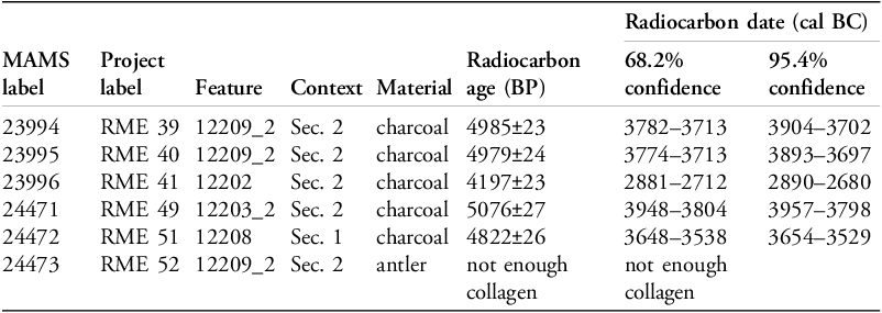
Radiocarbon dates for the Western Drift were obtained from five charcoal samples using accelerator mass spectrometry (AMS) at the Curt-Engelhorn Centre for Archaeometry in Mannheim, Germany (Table 1). The charcoal samples were prepared according to the standard procedure, and the results were calibrated using the IntCal20 calibration curve (Reimer et al. Reference Reimer2020) and modelled using the Bayesian modelling function in OxCal v.4.4.4 (Bronk Ramsey Reference Bronk Ramsey2009).
Radiocarbon data for Curak.

Four samples were taken from the layers of mining residues (Figure 6). Since these layers need to be regarded as backfilled material, the dates provide only a terminus ante quem for the exploitation of the Western Drift. The time span represented covers mainly the first half of the fourth millennium cal BC. During modelling, two samples (MAMS-23994 and MAMS-23995) were combined using the R_Combine function as they were pieces of the same charcoal fragment (Figure 9). Sample MAMS-24471 probably shows an old wood effect, as the obtained posterior density estimate does not fit into the relative stratigraphy of sediments. The last sample (MAMS-23996) was taken from an erosion layer on top of the stratigraphic sequence.
Bayesian chronological modelling for the Curak mine, created in OxCal v.4.4.4. (B.A.: Bronze Age; Fin: Final) (figure by authors).

Bayesian modelling of the dates takes the stratigraphic sequence of samples into account and demonstrates two separate episodes of human activity at Curak. An initial period of copper-ore exploitation began in the Final Chalcolithic, c. 4132–3655 cal BC (at 95.4% probability; Curak Final Chalcolithic Start; Figure 9) and continued for several hundred years (Curak Final Chalcolithic End; Figure 9) until 3649–3117 cal BC (95.4% probability) when the mining process appears to have stopped. The second episode of human activity (denoted as Curak Proto Bronze Age Start and Curak Proto Bronze Age End in Figure 9) is illustrated by a single charcoal sample (MAMS-23996) that can be modelled between 3406–2701 cal BC and 2891–2163 cal BC (at 95.4% probability). In summary, a probable start of the first episode can be placed from 3800 until 3500 BC, while for the second the probable span is 2900–2350 BC.
Provenance analysis
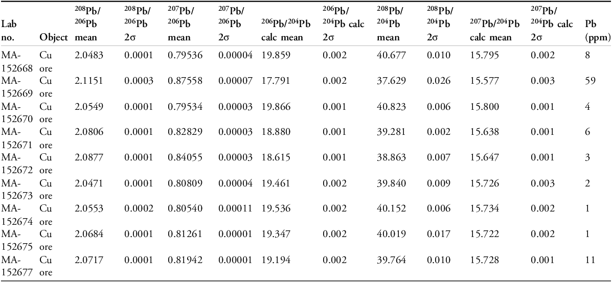
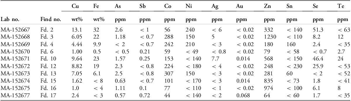
Copper-rich ore was collected from locations across the Jarmovac Valley (Figure 1: surveyed area; Tables 2 & 3). Lead isotope and trace element analyses were conducted on nine and 10 samples, respectively, using MC-ICP-MS (multicollector inductively coupled plasma mass spectrometry) and NAA (neutron activation analysis) techniques at the Curt-Engelhorn Centre for Archaeometry. The lead isotope data (Table 2) display a wide scatter across the 206Pb/204Pb isotope abundance ratios (Figure 10A). This is indicative of a highly radiogenic character across the Jarmovac ore field; a characteristic also documented in copper ores from Rudna Glava and in the Čadinje copper deposit in south-west Serbia (Pernicka et al. Reference Pernicka, Begemann and Schmitt-Strecker1993: 51, fig. 19).
Results of provenance analysis of Jarmovac ore.

Results of trace element analysis of Jarmovac ore.

A) Comparison of Jarmovac ore isotopic field with nearly 200 datapoints from the fifth- and fourth-millennium BC Balkans (Pb 206/204 projection) (data published in Pernicka et al. Reference Pernicka, Begemann and Schmitt-Strecker1993, Reference Pernicka, Begemann, Schmitt-Strecker, Todorova and Kuleff1997; Radivojević Reference Radivojević2007, Reference Radivojević2012; Radivojević et al. Reference Radivojević, Rehren, Pernicka, Šljivar, Brauns and Borić2010a, Reference Radivojević, Roberts, Marić, Kuzmanović-Cvetković and Rehren2021a); B) trace element data for the Jarmovac and Rudna Glava ore fields compared against selected Vinča culture production evidence (figure by authors).

Comparison of nearly 200 copper artefacts from the Balkan Early (Vinča and Hamangia cultures) and Final Chalcolithic, and Proto Bronze Age (spanning c. 5000–3200 BC; Figure 10A) illustrates the radiogenic character of Jarmovac ores. The tight cluster of these artefacts away from the Jarmovac scatter suggests the lack of isotopic correlation between the Jarmovac ore field and the analysed artefacts. This is not the case for Majdanpek, which clusters with the Final Chalcolithic artefacts (Figure 10A). The Jarmovac ore field, much like Rudna Glava, does not show consistency with the plotted dataset. This is not wholly unexpected, however, as most of the artefacts included in the plot date from outside the peak periods of activity at Curak, while the plotted fourth-millennium BC artefacts are already known to match eastern Serbian ore isotopy (Pernicka et al. Reference Pernicka, Begemann, Schmitt-Strecker, Todorova and Kuleff1997: 101, tab. A3). As these artefacts were found several hundred to more than a thousand kilometres away from Curak, and from a region with abundant copper deposits (Bulgaria), this inconsistency aligns with expectations.
Trace element analysis of the Jarmovac ore field is equally inconclusive (Table 3, Figure 10B). High cobalt (Co) and nickel (Ni) readings in Jarmovac ores are consistent with copper ores used in the early metal production processes (fifth millennium BC) across the Vinča culture in Serbia (Pernicka et al. Reference Pernicka, Begemann and Schmitt-Strecker1993, Reference Pernicka, Begemann, Schmitt-Strecker, Todorova and Kuleff1997, tab. A3; Radivojević Reference Radivojević2007, Reference Radivojević2012; Radivojević et al. Reference Radivojević, Rehren, Pernicka, Šljivar, Brauns and Borić2010a, Reference Radivojević, Rehren, Pernicka, Radivojević, Roberts, Marić, Kuzmanović-Cvetković and Rehren2021b). Comparison of trace elements from 90 Vinča artefacts revealed three samples taken from slag found at the sites of Belovode and Vinča-Belo Brdo (Figure 10B) that bore a strong similarity to the Jarmovic ore field. Copper ore from Rudna Glava also shows high Co and Ni readings, yet neither Jarmovac nor Rudna Glava ores show a consistent overlap with slag from Belovode and Vinča-Belo Brdo. As argued elsewhere, it is not possible to confirm whether Rudna Glava provided copper ores for Vinča-culture metal production, although the chemical composition of smaller ore outcrops in eastern Serbia suggests that Vinča communities most likely exploited the ore deposits in this region (Radivojević et al. Reference Radivojević, Rehren, Pernicka, Radivojević, Roberts, Marić, Kuzmanović-Cvetković and Rehren2021b). Co and Ni readings from copper-based artefacts in later periods, until the Proto Bronze Age, c. 3700–3200 BC (data in Pernicka et al. Reference Pernicka, Begemann, Schmitt-Strecker, Todorova and Kuleff1997: tab. A3), is much lower, consistent with neither Jarmovac nor Rudna Glava.
Reconstructing copper mining at Curak
The Jarmovac Valley was settled in the mid-sixth and early fifth millennium BC, evidenced by radiocarbon dates and material culture from the site of Kaluđerske Livade, 1.6km south-west of Curak (see OSM). Though it is not currently possible to determine whether the exploitation of copper ore from the Jarmovac ore field pre-dates the early fourth millennium BC, we can now reconstruct the mining process at Curak. Early miners likely followed secondary mineralisations along geological faults to reach the primary ore body, which was not visible on the slope surface due to its orientation and dipping but could have been accessed after only a few metres of digging. The primary ore body was exploited north-west and south-east, with the Western Drift being the last attempt to follow it westward, where it descends deeper. The Western Drift was mined from the top, creating a decline in the floor towards the southern wall that reflects the structure of the ore body. Initially mined from the south, ore extraction extended beyond the drift’s wall, causing destabilisation and filling the bottom with mining debris. This led to continued extraction along the northern wall, where deep gouges indicate ore removal. After northern wall exploitation ceased, mining continued elsewhere, filling the drift with waste.
Hammer stones and antler tools were used to drive the mine and extract ore; minimal charcoal presence makes extraction through fire-setting unlikely or at least infrequent. Heavy wear to some hammer stones indicates direct rock breaking, while lighter wear to others suggests their use for lighter tasks, such as driving antler tools into rock cracks to loosen and break out larger blocks. Antler tools likely served as wedges or chisels in this process.
Stone and antler tools, alongside fire-setting, were also employed at Rudna Glava and Ai Bunar, albeit with distinct applications. At Rudna Glava, fire-setting combined with stone hammers dominated shaft extraction methods (Jovanović Reference Jovanović1982: 143; for contrasting opinion see Weisgerber Reference Weisgerber1983). Various hammer stone shapes suggest specialised tool use (Jovanović Reference Jovanović1982: 141; Hauptmann & Weisgerber Reference Hauptmann, Weisgerber and Born1985: 20), while antler tools, including picks and wedges, were less numerous. Fire-setting was favoured at Ai Bunar, with stone tools absent in the mines but used nearby for ore processing (Chernykh Reference Chernykh1978: 212).
Tool changes reflect varied rock extraction methods in different geological conditions. At Rudna Glava, within metamorphic and magmatic rocks rich in quartz, fire-setting was effective (Krajnović & Janković Reference Krajnović, Janković and Jovanović1995: 50; Staudt et al. Reference Staudt, Goldenberg, Scherer-Windisch, Nicolussi, Pichler, Turck, Stollner and Goldenberg2019: 115). For the clear-cleaving carbonate rocks of Ai Bunar, fire-setting and wedges facilitated ore extraction. Meanwhile, pillow lava at Curak, weakened by frequent cracks, allowed the effective use of wedges and stone hammers, though fire-setting may have been necessary for extracting large rock sections. These adaptations highlight mining strategies tailored to local geological challenges and ore characteristics.
Discussion
When critically reviewing the earliest dates for copper mining in areas of Europe with feasible geology for prehistoric extraction, it is evident that the earliest copper mining in several regions corresponds with the earliest widespread evidence for copper objects: the Balkans in the fifth millennium BC, Italy in the fourth millennium BC, southern France in the late fourth–third millennium BC, Iberia in the early–mid third millennium BC and Ireland/Britain in the mid–late third millennium BC (O’Brien Reference O’Brien2015; Schauer et al. Reference Schauer, Shennan, Bevan, Colledge, Edinborough, Kerig and Parker Pearson2021). The compositional, isotopic and networks evidence from the copper artefacts in these areas also strongly supports regional models of copper production and distribution (e.g. Radivojević & Grujić Reference Radivojević and Grujić2018). It is probable that the transmission of copper mining expertise from south-east to north-west Europe was at least initially an externally driven process. There is, however, one major exception to this trend. In Central Europe, the evidence suggests that copper ore extraction from the late fifth/early fourth millennia BC onwards was on a small-scale, regional basis (Moesta Reference Moesta and Lippert1992; Höppner et al. Reference Höppner, Bartelheim, Huijsmans, Krauss, Martinek, Pernicka and Schwab.2005; Stöllner Reference Stöllner, Oeggl and Prast2009; Eibner Reference Eibner, Bartelheim, Horeijs and Krauss2016; Scharl Reference Scharl2016). Yet, many copper artefacts from this period in Central and Northern Europe can be provenanced to Balkan sources, indicating the primacy and continuing importance of these sources (Frank & Pernicka Reference Frank, Pernicka, Midgley and Sanders2012).
Dating of the start of mining activity at Curak in the Jarmovac Valley to around 3800 cal BC (Figure 9) provides the first direct evidence for copper extraction in the central Balkans during this period—a period that has traditionally been seen as a ‘bust’ following the fifth-millennium BC ‘boom’. The timing corresponds with the earliest record of environmental lead pollution in Europe c. 3900–3500 BC, based on the peat bog sequence from eastern Serbia. The same sequence also revealed a concurrent rise in charcoal concentration, indicating an increase in biomass burning, perhaps as fuel, among a broader range of economic activities (Longman et al. Reference Longman, Veres, Finsinger and Ersek2018). This indirect suggestion of substantial mining and metallurgical activities in the early–mid fourth millennium BC is yet to be matched by archaeological evidence, although isolated finds of arsenical copper production have been recorded for the mid-fourth millennium BC in Serbia (Radivojević et al. Reference Radivojević, Rehren, Blagojević and Tykot2010b). Thus, just as the models of a Balkan societal collapse in the fourth millennium BC are now being seriously challenged with new radiocarbon dates and excavations on both new and old sites (Tsirtsoni Reference Tsirtsoni, Nikolov and Schier2016; Bulatović & Milanović Reference Bulatović and Milanović2021), it seems that a contemporary metallurgical collapse should also be re-evaluated. Instead, this period likely marks the rise of a pan-European metal trade network originating from Balkan production centres (cf. Rosenstock et al. Reference Rosenstock, Scharl, Schier, Bartelheim, Horejs and Krauss2016), which contrasts sharply with the more localised pan-Balkan metal circulation of the fifth millennium BC that has garnered attention due to its greater archaeological visibility.
Conclusion
A visibility bias in the interpretation of early metal production and consumption (cf. Taylor Reference Taylor, Young, Pollard, Budd and Ixer1999) remains hugely influential in shaping broader narratives. This is despite the potential for the widespread recycling of metal and the frequent destruction of traces of early mining by subsequent activity, as at Majdanpek. Compositional and isotopic analysis of artefacts can highlight the intensive exploitation of specific geological sources, even in the absence of direct evidence for prehistoric mining in such regions, as well as the widespread trade in metal from these sources. This can be followed up with the intensive survey of mining regions and subsequent targeted excavations, as at Curak, where direct evidence for primary production can be found. Taken together with environmental analyses, these approaches can not only challenge long-held assumptions but also enable the exploration of a more nuanced narrative beyond ‘boom’ and ‘bust’.
Acknowledgements
The authors are grateful for the unreserved support from the Homeland Museum in Priboj on Lim and local hospitality during the survey and excavation seasons.
Funding statement
Financial support for this project was received from the Arts and Humanities Research Council-funded project ‘The rise of metallurgy in Eurasia: evolution, organisation and consumption of early metal in the Balkans’ (AH/J001406/1).
Online supplementary material (OSM)
To view supplementary material for this article, please visit https://doi.org/10.15184/aqy.2025.66 and select the supplementary materials tab.





 Open access

