


Introduction
Outside of the Rift Valley, the lowlands of Ethiopia have received little archaeological research attention, with the semi-arid lowlands in the south-central parts of the country remaining particularly underexplored. The dearth of archaeological data from securely dated and fairly continuous sequences limits a comprehensive understanding of the later prehistory of the Horn of Africa (e.g. Clark Reference Clark1954; Brandt Reference Brandt1986; Assefa et al. Reference Assefa, Pleurdeau, Duquesnoy, Hovers, Pearson, Asrat and Lam2014; Lesur et al. Reference Lesur, Hildebrand, Abawa and Gutherz2014). The persistence of poorly defined, traditional higher-level classifications, such as the Later Stone Age, add further complications by masking technological and behavioural variability across the Terminal Pleistocene and Holocene. Long-term research programmes aimed at resolving these issues are long overdue in this region. We report here the discovery of several cave and rockshelter sites from previously unexplored limestone karst formations along the Arsi-Bale lowlands of Ethiopia.
Survey and test excavation
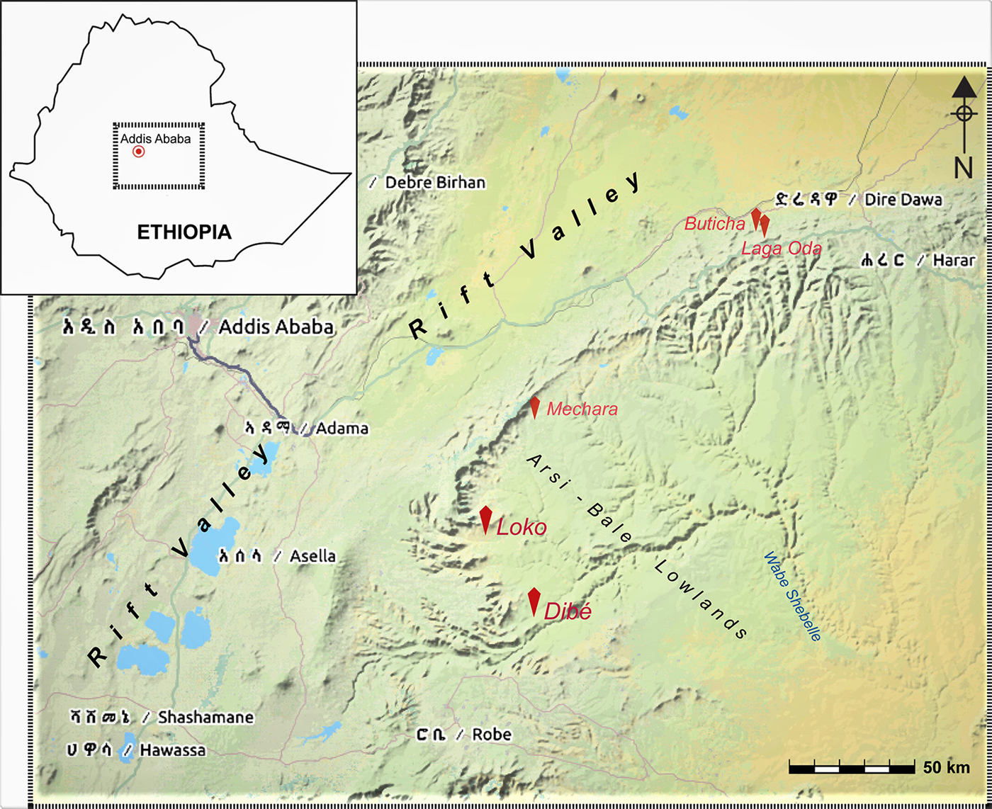
In 2017, our team conducted a survey of the karst landscapes across the semi-arid Arsi-Bale lowlands and margins (Figure 1). This led to the discovery of 27 caves and rockshelters in 12 loci spanning various geological, topographic and ecological zones. Karst landscapes in two localities were identified as particularly promising for further investigations by virtue of their material remains, rock paintings and, in some locations, speleothems (mineral deposits) suitable for high-resolution palaeoclimatic reconstruction.
Map showing the location of limestone karst systems and archaeological sites in south-central and eastern Ethiopia (map credit: OpenStreetMap).
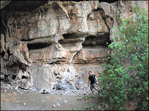
The first group of caves are aligned along a prominent, north-facing karst ledge overlooking the Loko River in the Gololcha district. Positioned at an elevation of 1230m, one of the Loko caves is 40m wide, 15m deep and 20m high (Figure 2a). Speleothems in this cave occur as both stalagmites and stalactites that are up to 4.5m high, and 50mm in diameter. Lithic artefacts are made from diverse raw materials and include flaked river cobbles, laminar flakes and blades, Levallois products, and multidirectional cores. An ellipsoidal cobble recovered partially exposed on the floor (Figure 2c) probably represents a grindstone, although a conclusive statement requires microscopic analysis. Several pieces of charcoal and coprolite were also documented and sampled. In most of the Loko caves, the silty to clayey aeolian sediments show limited signs of post-depositional disturbance, and no bioturbation inside of the dripline (a line on the ground at the cave entrance formed by drips from the rock above), thus proving to be suitable for future systematic excavation.
Loko: a) the largest cave with speleothems and artefacts; b) Levallois flakes (top = dorsal view; bottom = ventral view); c) ‘grindstone’; d) small laminar blade (photographs by Yonatan Sahle).
The second significant cluster of archaeological sites occurs in the karst landscape marking the lowlands of the Seru district. Here, rockshelters are located along the walls of steep river gorges or on scarps overlooking wadis. The broader Seru lowlands, marked off from the adjacent plateaus by an abrupt elevation drop of >1000m (Figure 1), contain a regionally extensive Jurassic limestone (Assefa Reference Assefa1988). The karst landscape along the Dibé wadi particularly dominates here.
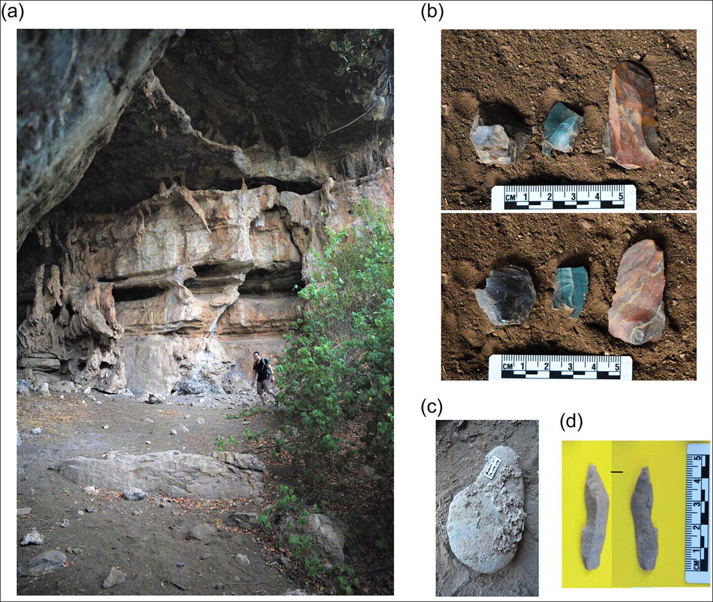
Prominent limestone ridges on either side of the Dibé gorge offer a commanding view of the wadi floor and the adjoining plain with short-growth plants and shrubs. The gorge contains several rockshelters with surface-scattered artefacts and rock paintings, conceivably due to its strategic location (Figure 3a–c). The exceptionally rich scatter of lithic artefacts, faunal remains and a panel of rock art on its back wall led to our prioritisation of one of the Dibé rockshelters for closer investigation. In 2018, we conducted controlled surface collection and test excavation of this rockshelter.
Dibé: a) panoramic view of the Seru lowlands; b) Dibé limestone wall as viewed from the main rockshelter; c) rock art in the main rockshelter (note the dripstone superimposing the paintings); d) surface-scattered artefacts and fossils; e–f) prismatic blade and discoid from the Dibé main rockshelter (photographs by Yonatan Sahle).

The closely studied Dibé rockshelter faces south-west, with the current dripline measuring only a maximum of 4m from the back wall, thus preserving a rather small part of the ancient living floor (Figure 3b–c). The density of eroded artefacts and the proximity of the fronting terrace and shelter talus (an accumulation of debris extending outwards from the dripline) to the wadi added a sense of urgency to the closer examination of this rockshelter. Particularly interesting is a surface scatter of prismatic blades, discoidal cores, a Levallois point, several backed microliths, and pieces exhibiting the micro-burin technique (Figure 3d–f). Adherent carbonate matrix on most of the exposed lithic and faunal pieces not only attested to the recent erosion of these, but also to the excavation potential in a setting devoid of ‘Neolithic’ finds, such as potsherds.
Finds from a 67m2 surface were collected from gridded units and bagged separately. Based on artefact density, clinging matrix and suitability for excavation, a 2 × 1m area was test-excavated near the back wall in the northern corner of the shelter. Excavation followed a combination of natural and artificial stratigraphy, so that spits normally followed the natural change in sediment type, with an artificial 0.1m break where no such change was noticed. The squares were excavated to a maximum depth of 0.75m below datum. The test excavation did not reach bedrock. Ensuing field seasons will expand excavations both laterally and vertically.
A total of 5285 artefacts were collected from the ground's surface, and 1885 were excavated from Dibé. Lithic raw materials are dominated by chert, whereas other raw materials include obsidian, basalt and quartz. Detailed examination of the archaeological materials as well as radiocarbon dating of the sequence are currently underway. All archaeological remains are housed in the National Museum of Ethiopia, Addis Ababa.
Rock art
The Dibé rock art (Figure 3c) represents yet another unique aspect that has added to the prioritisation of archaeological excavations and chronological work there. Interestingly, the Dibé rock paintings lack the stylised or naturalistic bovine depictions common elsewhere in the country—where horns, humps or udders are often exaggerated (Brandt & Carder Reference Brandt and Carder1987). The earliest rock paintings from Ethiopia are estimated to date to the Mid-Holocene arid phases (which started c. 6000 years BP), based on stylistic and thematic attributes. Our initial stylistic comparisons suggest that anthropomorphic, animal and possibly hunting and/or herding depictions at the Dibé rockshelter show salient features that contrast those known from across the Horn of Africa. Ongoing studies of thematic, chronological and other aspects of the Dibé rockshelter paintings are expected to provide interesting information. If current attempts to date the Dibé figurative art directly using U-series methods on calcite samples superimposing the pigment layer succeed, they will add to a very limited number of securely dated examples on the African continent (Richter & Vogelsang Reference Richter, Vogelsang, Limpricht and Biesele2008; Bonneau et al. Reference Bonneau, Pearce, Mitchell, Staff, Arthur, Mallen, Brock and Higham2017). Considering the proximity of the surveyed areas to karst systems with detailed palaeoclimatic data (Asrat et al. Reference Asrat, Baker, Leng, Hellstrom, Mariethoz, Boomer, Yu, Jex and Gunn2018), the launching of such a long-term archaeological research programme in this region promises a wealth of information.
Acknowledgements
Research was conducted under permission from the Authority for Research and Conservation of Cultural Heritage of Ethiopia to Y.S. We are grateful for kind support from D. Dagne, S. Scheiffele, K. Geleta and several other colleagues in the Arsi Zone. Funding support for the 2018 fieldwork at Dibé was generously provided to Y.S. by the Paleontological Scientific Trust.


