

From 1799 to 1804, Prussian naturalist Alexander Von Humboldt, reputed today as one of the founders of modern geography, traveled extensively throughout Spanish America. He visited Cuba, New Granada, Peru, New Spain, and explored two of the major rivers in northern South America, the Orinoco and the Magdalena. Unlike the Orinoco, the Magdalena was not a backland river. In fact, by the time of Humboldt’s travel, it was the main fluvial artery of the viceroyalty of the New Granada. From its source in the Colombian Massif, this river flows northward for about 950 miles, pouring its water into the Caribbean Sea, connecting the Andean highlands with the Caribbean plains, and finally, with the Atlantic Ocean. During the sixteenth century, this south–north course allowed Europeans to penetrate a major part of northern South America and organize their rule over these diverse environments. For almost four centuries, the Magdalena was the privileged way for connection and communication between Santa Fe, New Granada’s capital, and the main urban centers located in the Andean interior with Spain and the Atlantic world. As an obligatory way to reach Santa Fe, then, Humboldt took the trip from Cartagena to the capital, taking the opportunity to observe and analyze the geography of the Magdalena.
In his travel journal, Humboldt dedicated many pages to describe the bogas, freemen of African and Indigenous descent who worked as boatmen on the Magdalena River. He highlighted their strenuous work and their racialized bodies:
Indisputably, there is no work of greater muscular effort than that of the rowers of the Magdalena River… [They] are zambos of Herculean force, rarely Indians, and go naked except for a loincloth. It is extremely picturesque when these bronzed bodies with their athletic strength move powerfully along, supported by their long poles. Their jugulars stand out each time they do so and they drip sweat daily for 13 hours in a hot, humid climate on a river where the wind hardly blows enough to move the leaves.Footnote 1
Humboldt’s admiration should not be mistaken for compassion; rather, annoyance best captures his feelings toward the bogas’ free way of life. He noted that “although their pay is very poor… they are free men and alternate between haughty, indomitable, and joyous.” Humboldt resented that, paid in advance, the bogas often squandered their wages on alcohol and frequently arrived late to work, leading him to bitterly remark that, “one is a slave to one’s own rowers.”Footnote 2
Humboldt’s observations capture the complex and often contradictory relationship between colonial and republican elites and the Magdalena River. New Granada depended greatly on the Magdalena River for both its political and economic internal and external articulation, and on the bogas for these connections to happen. Despite this dependency, elite members were unfamiliar with water geographies and greatly despised riverine ways of life. Paradoxically, bogas possessed a unique knowledge and expertise of the fluvial geography and its navigation. These men transported the people, commodities, and information needed by the Spaniards to establish their rule in this territory and ensure its functioning, and this placed them at the heart of the viceroyalty’s transportation and communication systems. The bogas represented, without exaggeration, the cornerstone of New Granada’s political, economic, and symbolic articulation.
This article explores the relationship of the bogas with the fluvial space, emphasizing the ways in which they became familiar with the Magdalena River,developed unrivaled navigational skills, and produced an exceptional environmental knowledge through their labor and the relationships they built along its shores. I argue that bogas’ critical role, still barely recognized by Colombian historical narratives, is explained not only by their relentless labor, but also by the close and historically deep relationships these men created with the river’s human and nonhuman actors after centuries of continuous travels up and down the river. The bogas’ highly mobile labor was not merely a mechanical action intended to move people and commodities, but also a way of life that led them to produce the very geography of the main river of the viceroyalty of New Granada.Footnote 3
This article traces a counterpoint between the perspectives of white men and bogas on fluvial geography, aiming to analyze the interplay between a dominant geography and a subalternized Afro-Indigenous geography. It seeks to illustrate how the Magdalena River geography was shaped amid these tensions. This analysis challenges economic and history of science narratives that portray the history of the Magdalena River as exclusively produced by white European and Creole men, thereby granting historical agency solely to these individuals. This article aims to contribute to the creation of a new historical narrative that recognizes the central role of Afro-Indigenous riverine communities as producers of geographical knowledge and as essential actors in fostering social and political connections both along the river and within and beyond the viceroyalty.Footnote 4
In this direction, Black Atlantic Geographies and Atlantic histories of knowledge making have shown the essential role that Africans’ past experiences and intellectual worlds played in this production of neotropical landscapes. Africans, they argue, were the chief actors in the Columbian exchange, “establishing production systems so fundamental to the environmental and social relations of the colonies.”Footnote 5 These two bodies of scholarship have been instrumental in demonstrating that Africans arrived to the New World with critical expertise, based on which they developed an environmental knowledge of the new geographies that was key to their survival, allowing us to overcome the vision of the enslaved as passive unskilled laborers.Footnote 6
This article aims to contribute to these bodies of literature by analyzing the key features of the environmental knowledge produced by Afro-Indigenous boatmen of the Magdalena River, as well as complicating them in two significant ways; first by expanding specifically on recent works that recognize water as a defining feature of the lives and cultures of African-descended peoples, shifting the focus from oceanic to fluvial geographies.Footnote 7 Rivers were key to the first human settlements across the Americas, and during European colonization, they became corridors of penetration, ways of communication and exchange with global networks, and privileged places of empire-making and local contestations.Footnote 8 However, traditional Atlantic history often prioritizes oceanic geographies, overlooking the intricate and multifaceted roles of freshwater landscapes. This text seeks to illuminate the complex interactions between Afro-Indigenous boatmen and these freshwater geographies, examining how their knowledge and practices shaped navigation, commerce, and social networks within this vital ecosystem.
Second, most of the literature that has been exploring the making and circulation of non-European environmental knowledge production in the Atlantic has tended to privilege the analysis of either plantation societies and/or areas where Africans comprised the majority of the population, such as the Antilles, the U.S. South, Brazil, and some urban settlements such as Cartagena. However, in many regions of the Great Caribbean where Africans arrived, they engaged in various activities and formed significant interactions with Indigenous populations, who still constituted a substantial portion of the area’s inhabitants. In these contexts, Africans participated in gold and silver mining, livestock raising, fisheries, and fluvial transport, creating diverse geographies shaped by intense interethnic exchanges with Indigenous peoples, which were central to the development of new regional cultures.Footnote 9 An analysis of the bogas, then, might contribute to better understanding the experiences of vast areas of South and Central America and build a more inclusive history of the African diaspora in the Americas.
This text is organized into four sections. In the first, I describe New Granada’s political geography to explain the bogas’ prominent role in transportation and communication. In the second section, I highlight the geography of the Magdalena River, in both its physical and imagined aspects, and describe the particular constraints it posed on navigation, and consequently, on the bogas’ work and lives. Here, I make evident the skills and knowledge needed to navigate and survive in this geography. In the third section, I narrate the transformation of a predominantly Indigenous labor force, in the sixteenth century, to a free mulato and zambo labor force during the seventeenth and eighteenth centuries, placing an emphasis on the interethnic nature of environmental knowledge production. In the last section, I analyze the organization of the bogas’ labor and experiences, arguing that this organization allowed them to build wide-ranging, intensive, and highly meaningful social networks along the Magdalena River that produced its landscape.
The Political Geography of New Granada’s Fluvial Landscape
The role of the bogas in the economic and political life of New Granada, and in the shaping of its fluvial landscape, is intricately tied to the political configuration of the whole viceroyalty and the Magdalena River’s role in it.Footnote 10 Unlike other viceroyalties and Audiencia capitals within the Spanish empire, New Granada’s capital was located far inland, in the Andean highlands. Santa Fe stood 653 miles from its main maritime port, the city of Cartagena.Footnote 11
Some historians argue that this location was chosen on the basis of the fact that the Andean highlands were home to the largest and most centralized Indigenous societies in northern South America. The Spaniards, therefore, established their major and most stable settlements inland, including the main administrative centers of Popayán, Tunja, and Santa Fe. The latter became the seat of the Real Audiencia in 1549. Consequently, New Granada’s inland territory fulfilled a different political, economic, and symbolic role; it was not an internal frontier, nor a backwater, but rather the very center of the body politic. This geopolitical configuration made New Granada an Andean-centered territory.Footnote 12
New Granada’s Andean inland focus therefore posed a critical challenge to the articulation of the relatively centralized Spanish empire, whose rule was nevertheless highly dependent on communication across vast distances. The audiencia and later viceregal capital was located a long way from its maritime port, and therefore far from its point of connection with the metropolis and the transatlantic trading circuits. Early settlers, as well as late-colonial officials, often referred to this distance. One relación from 1572 stated that “This Kingdom is located more than 200 leagues from the coast and is reached by traveling up the Magdalena.”Footnote 13 A postal service official, analyzing communications in New Granada in 1785, pointed to a feeling of remoteness: “its provinces, more than other provinces of America, are far removed from trade with Spain, either because they are not abundant in commodities or because their roads are extremely difficult.”Footnote 14
In addition to the distance referred to in the relación, there was only one official way to connect capital and port: the Magdalena River. Simply put, Spanish rule in northern South America was dependent on this body of water. The interplay between geography and politics explains this relationship. The headwaters of the Magdalena River, which flow from south to north for about 950 miles, are located far inland, in the Colombian Massif, a mountainous structure where the Andean range divides into three branches. The river’s mouth, on the contrary, lies on the Caribbean Sea, some 63 miles north of Cartagena Bay. The river traversed New Granada from south to north and this orientation partly explains the river’s crucial role in the Spanish conquest and settlement, and eventually, in the territory’s political and economic articulation. The Andean interior possessed rich deposits of gold, silver, and emeralds and was home to large, complex Indigenous populations, both factors that attracted Spanish conquistadors, and the river made it relatively easier to travel inland. Expeditionary armies, with the help of Caribbean indigenous peoples, made their way inland along the river and founded Santa Fe in 1538, the city that 10 years later would become the capital of a new audiencia of the same name (1549).Footnote 15
Given the need to connect this inland capital with the Caribbean, the Spanish found and proposed various possible overland routes, but after long political struggles among the cities that would benefit from or be affected by the opening of the different routes, the Crown decreed that the Magdalena River would remain the main official route to transport goods, people, and communications between Cartagena and Santa Fe.Footnote 16 The Magdalena River’s main role was therefore both a byproduct of geographical constraints and a consequence of a political decision (a fact not yet fully recognized by Colombianist scholars, who stress only geographical reasons).
The Crown’s decision meant that, during all of the colonial period, all the people that materially and symbolically built the Empire through their “administrative pilgrimages” and all the goods that made material reproduction possible and created a sense of connection, simultaneity, and belonging, entered and circulated along this river. Government offices depended on the mobilization of employees and priests, as well as the movement of funds and information.Footnote 17 All newly named officials and priests coming from the Atlantic traveled this route. The highest civil, military, and ecclesiastical bureaucratic ranks, such as governors, royal officials, oidores (high court judges), bishops and archbishops, and audiencia’s presidents and viceroys, as well as their entourage and families, traveled the river. Wholesale and lesser traders, consulate agents, adventurers, travelers, deserters, and migrants all moved along the river. Both official trade and contraband coming from Jamaica and Curaçao entered the viceroyalty by way of the river (from Caribbean ports such as Santa Marta to Magdalena’s main fluvial ports of Mompox and Honda, and finally to Santa Fe).
Luxury goods greatly coveted by the elites, such as wine, oil, olives, cotton textiles, silk fabrics, decorative textiles, hats, clocks, furniture, and even pianos arrived in Cartagena and were distributed to Santa Fe and other interior cities (Popayán, Medellin, Santa Fe de Antioquia) via the Magdalena River.Footnote 18 The precious metals and goods upon which the imperial economic system depended—New Granada’s main metal export was gold—taxes, and official communications were all transported by river from the capital to the seaport. Steel and iron coming from Spain were also distributed to the viceroyalty by way of the Magdalena,Footnote 19 and the Imperial defense centered on Cartagena’s fortresses and on the military posts along the river.
New Granada depended on the river not only to articulate its rule, but also to ensure regional and local connections. Gold mines in the west received supplies, enslaved people, food, and clothing via the river. They, in turn, sent the gold along the river to be minted in Santa Fe. Almost all communications sent by the audiencia or the viceroy to the provinces passed this way at some point, including royal decrees and all kinds of administrative documents.Footnote 20 Regional and local authorities used the river to send their reports, padrones, requests, complaints, and appeals to the court of Santa Fe.
The river’s importance for New Granada’s internal security was made clear during the 1781 Comunero Revolt, when controlling the river and interrupting communications became a major goal for the rebel leaders. Viceroy Manuel Florez, living in Cartagena at the time, was unable to communicate with the audiencia’s ministers in Santa Fe and could not send any orders or guidance as to how to deal with the rebellion. Finally, the viceroy sent troops upriver to fight the rebels.Footnote 21
The security of the Empire also depended on the river, as it was often feared that foreigners might take to the river to spy or even invade. In 1797, for instance, Viceroy Pedro Mendinueta wrote to the Governor of Cartagena after receiving some news of a small boat seen navigating the river with 16 men aboard, whom witnesses presumed to be foreigners because of their clothes and language. The officials suspected them of being French and trying to sound and map the river, so Viceroy Mendinueta warned the Governor of Cartagena to remain alert to the “introduction of foreigners via the Magdalena River, a delicate issue deserving all his attention.”Footnote 22
New Granada’s trade and communication system hinged, then, on the river and operations depended entirely on the bogas, whose lives were inextricably entangled with the river. As long as this waterway remained the principal means of communication between the country’s interior and the outside world, the bogas remained responsible for the mobilization of people, goods, and information. Even after the arrival of steam navigation, bogas, now recruited as steamboats’ crews, continued to play this key role.Footnote 23 The bogas’ expertise and knowledge drove Colombia’s economy even until the early twentieth century, when political and economic elites began searching for the “more efficient and civilized means” of transportation and communication that eventually seized the role of the Magdalena.
Meandering along Brown Waters and Tropical Forests
Kevin Dawson invites historians to consider the influence of hydrography on historical processes, emphasizing an understanding of hydrological variables—especially the differences between blue (deep ocean), green (shallow coastal areas), black (swamps), and brown waters (navigable rivers and littoral areas)—and their effects on human lives.Footnote 24 In response to Dawson’s invitation, this section delves into the unique challenges encountered by the bogas as they navigated the Magdalena’s winding brown waters. However, since bodies of water cannot be fully understood without considering their connections to the broader environment, this section also reflects on the physicality of water and tropical forests and the ways in which the bogas engaged with them.
A common feature of all rivers is the way they form up in the mountains and flow downhill through the action of gravity, emptying their waters into other bodies of water. Aside from these characteristics, however, each river is unique. The Magdalena’s topography, geology, climate, and environment made it very different from other navigable rivers of the Atlantic basin. The Magdalena is not a large river when compared with the massive courses of the Orinoco, the Amazon, the Mississippi, the Niger, or the Congo. And yet, in just 950 miles, the Magdalena drafts larger amounts of sediments than most of these rivers. This is due, in part, to its geomorphology. This Andean watercourse is a young river, geologically speaking, and its waters flow over significantly steep terrain characterized by high tectonic activity and slopes that commonly exceed 45 degrees. The river’s navigable portion—between approximately 500 miles from the city of Honda to its mouth in the Caribbean—is less inclined than its upper section, as happens with all rivers; however, the Magdalena’s waters, in general, run swifter than any other larger Atlantic River.Footnote 25
This feature has been a central element in European and Creole’s imagination of the river and has influenced scholarly discussions since the eighteenth century. It continues to be a definitory topic among contemporary hydrologists and was also noted by Humboldt, who compared the Magdalena River to the Orinoco River during his travels.Footnote 26
The bogas managed this strong current by using a peculiar navigation technique that included the use of four principal types of embarkations varying from the largest, the champán and bongos, to the smaller and speedier piraguas and canoas used for shorter or faster trips. All of these vessels were made from local woods, such as cedar, and were propelled using long poles that the bogas plunged into the water and to the bottom of the riverbed before walking forward in the boat and then using the strength of their bodies to generate leverage and propel the vessel forward.Footnote 27 This action was carried out with perfect coordination by crews of 4–12 bogas, depending on the size of the embarkation, over and over, continuously for 12 hours a day, over the course of days and even months.
When traveling upriver, the bogas had to keep the embarkation close to the riverbank and away from the middle, where the current is stronger and the bottom of the river was at times too deep for their poles.Footnote 28 Furthermore, the Magdalena’s bed is highly uneven, and in some sections, very rocky, which creates turbulent and perilous rapids, undercurrents, and different flow patterns quite difficult and dangerous to navigate. The bogas learned to pilot their boats by recognizing the sparkles and reflections on the river’s surface that indicated its depth, and by identifying tree branches and rocks along the shore that might help them to propel the boat and avoid undercurrents.Footnote 29
Many European and Creole travelers who wrote about their journeys remarked on how well the bogas moved on the boats, keeping their balance as they walked along the moving vessel, pole in hand. Their swimming skills were also celebrated and especially demonstrated when goods fell into the water. These travelers described these skills always in sharp contrast with their own self-perceived clumsiness at not being able to remain upright while the boat was moving and fearing a fall into the water, as Colombian journalist Joaquín Borda wrote in 1866 about his travels:
All aboard, white man! The boss (main boga) shouted at me, already clutching the rudder, preparing to turn the boat. When I hesitated, for fear of wetting myself or of falling into the river as I boarded, a boga lifted me, as if I were a feather, and placed me in my spot.Footnote 30
The Magdalena River is also known for its high inter-annual rainfall variability due to the alternating dry and wet seasons typical of tropical climates. Its fluvial discharge and sediment loads are therefore delivered over short periods of time. This led to the formation of numerous sand islands along the river’s constantly changing course, which appeared during the dry season and disappeared during the wet season. Mud barriers are also common and the river’s depth reduces drastically during the dry season.Footnote 31 This mutability increased the complexity of navigation, but the bogas became adept at identifying the continually changing channels and islands to guide embarkations without the use of buoys or charts, taking care not to enter channels with no exit. The bogas produced complete mental maps of an always-changing river that was only fully cartographed by Alexander Von Humboldt and Francisco José de Caldas at the beginning of the nineteenth century.Footnote 32
The bogas also became fluent in the neotropical forests along large portions of the river. Over the course of their lifetimes, bogas were hired to work in either large or small trips, thus while some traveled between the two main fluvial ports—Mompox and Honda, separated by a distance of approximately 300 miles—others regularly made smaller trips between neighboring towns on the Caribbean plains, navigating other rivers such as the Cauca, San Jorge, and Cesar. In addition, during the rainy season, when long-distance navigation was less frequent, the bogas alternated navigation with other activities such as fishing and agriculture. Ciriaco Gutiérrez, for instance, a boga from Sabanagrande who lived in Mompox, declared his trade “to be that of farmer and boga on the Magdalena River.”Footnote 33
Thanks to long-distance travel and the alternation of activities, bogas accumulated extensive knowledge of flora, fauna, soils, geomorphology, and weather along both the lower and middle sections of the river, the Caribbean plains, and the inter-Andean valley. These sections experience important biogeographical differences, as they are characterized by the alternance of both humid and dry tropical forests, with the latter being more predominant. Tropical dry forests are characterized by high biological diversity, including many endemic species, but exhibit lower plant diversity compared with wetter tropical forests due to significant seasonal rainfall variability. These forests experience marked dry periods with precipitation often below 100 mm. This seasonality drives various adaptations in flora and fauna. Plants and animals develop morphological, physiological, and behavioral strategies to cope with high temperatures and water scarcity. For instance, mammals may undergo seasonal hibernation and exhibit flexible diets, migration patterns, and adjusted breeding and foraging behaviors, akin to adaptations seen in desert environments.Footnote 34
Bogas were able to adapt to this variability and integrate biogeographic areas usually understood and imagined by western geographers as separate units.Footnote 35 The fauna and flora of these forests provided the bogas with food and opportunities for cooking, healing, shelter, boat repairs, and more. On their journeys, the bogas were often the only ones capable of identifying edible species such as manatees, turtles, and fish, and they knew where and how to find iguana’s eggs, an essential part of their diet. They also managed animals that posed a threat to travelers, such as poisonous snakes and alligators, and were responsible for hunting, fishing, and cooking. The bogas could identify edible, curative, and toxic plants and they were familiar with American species, such as cassava, from which they prepared the staple known as cazabe, and knew how to use the nonnative species that had adapted well to neotropical forests, such as plantain, to which both bogas and river dwellers gave several different uses, as a writer expressed in a fictional tale about bogas published in 1866, amused by their use of plantain leaves as tablecloth.Footnote 36
This same forest fauna and flora was perceived quite differently by the bogas’ passengers. Although European and Creole travelers no doubt admired “the magnificent vegetation” and were especially drawn to the huge cedar and ceiba trees, they felt threatened and even helpless before the snakes, the “fearsome mosquitoes,” the crocodiles, and the “frightening miasmas.” Humboldt recounted, for instance, that while asleep one night, a coral snake, one of the most colorful but also poisonous tropical snakes, crawled into his bed and “had it not been for the Indians who killed it,” he would have received a deadly bite. This anecdote illustrates the self-perceived vulnerability of European and Creole travelers in the face of this “profuse” and “dangerous” nature. The bogas’ environmental expertise and navigational and physical skills, in contrast, earned them an ambivalent admiration and led a Colombian statesman to even describe them as “semifish.”Footnote 37
This half-human-half-fish nature summed up the dexterity with which the bogas moved between land and water, a characteristic that Colombian sociologist Orlando Fals Borda labeled as “amphibious culture,” a concept that highlighted the especially close relationship that riverine dwellers of the lower Magdalena in general, and bogas in particular, built with waterscapes.Footnote 38 After centuries of daily navigation, the bogas could interpret the river’s visible surface as well as its unseeable bottom, and read its shores, plants, rocks, sounds, and movements—or lack of them—and so on. Furthermore, the bogas’ knowledge of their environment was expressed not only in their abilities, but also, most importantly, it was embodied and expressed in the ways their bodies moved on the boat and on land and water.
These skills and environmental knowledge allowed the bogas to materially and symbolically invert imperial hierarchies of status and race. According to Hispanic notions of blackness and calidad, Black people were supposed to show deference to white Europeans and Creoles. Even if free, they were expected to submissively obey the orders and desires of white men and women.Footnote 39 However, on the Magdalena River, European and Creole passengers, as well as any other travelers, were completely subject to the control and will of the bogas for the duration of the trip, which could last days, weeks, and even months. The bogas determined departure times, pace, duration and place of stopovers, and the complete itinerary, and were responsible for safety on the boat and on shore while also procuring and preparing food and beverages. The white and Creole elite, simply put, could not make a move without the bogas’ consent and without endangering their goods, money, time, and even their own lives. Passengers relied absolutely on these Black and zambo men, a relationship expressed perfectly by Humboldt’s assertion of travelers being the bogas’ “slaves.”
The bogas, perfectly aware of this relationship, often took advantage of it by refusing to depart or embark goods, or by continuing to row, making noises that annoyed whites and made the trip “miserable,” or even by simply abandoning the boats and leaving passengers to their own devices. Passengers were not the only ones aware of this situation; high court officials living in Santa Fe, such as notorious fiscal protector Antonio Moreno y Escandón, also clearly described the situation:
The fiscal protector … claims that the excesses and disarray committed by the bogas on the Magdalena River are not only justified, but are notorious throughout the Kingdom, and well known are the damages to the public and to commerce following [the bogas’] escapes and their abandonment of the canoes and due to their pride and brazenness during the journey, and that, emboldened by their number and the distance from any town, they force traders to suffer their insults and arrogances, and it is therefore believed that this abuse is worth remedying in that the greatest part of said bogas are mulatos and zambos and perversely inclined by nature to be more frequent in their excesses…Footnote 40
Scholars have been evidencing how different geographies created opportunities for subalternized individuals and groups to contest power relationships. Geographer Judith Carney, for instance, explained how agricultural knowledge of rice allowed African enslaved persons to negotiate the terms of their bondage.Footnote 41 Historians of the Early Atlantic have reflected on how these opportunities translated into the redefinition of notions of race and status and the acquisition of economic benefits.Footnote 42 Kevin Dawson, in particular, analyzes how African enslaved pilots of merchant and naval ships in Anglophone America used their knowledge of green waters as a way to gain unparalleled privileges that allowed them to invert racial/social hierarchies. The ever-changing nature of hydrospaces made charts and guidebooks unreliable, rendering navigational skills a prized asset for African enslaved pilots. They often assumed command, superseding even the captain, transforming their advice into directives and assuming the role of captains, exerting de facto authority over white sailors and officers.Footnote 43 The Magdalena River bogas share certain similarities with these enslaved pilots; however, they enjoyed even greater authority. Fluvial navigation on the Magdalena River was monopolized by the bogas. All crews were exclusively composed of bogas, with no higher authority over them during their journeys. Furthermore, Spanish authorities never established a riverine army or anything akin to their naval force.Footnote 44
The brown waters of the Magdalena River have always been notoriously tumultuous and challenging to navigate. This has been evident since the colonial era, presenting obstacles for traditional rowers, nineteenth-century steamboats, and contemporary vessels in the twentieth first century.Footnote 45 And yet, over the course of these four centuries, the bogas remained the greatest experts in navigating its waters. They possessed the greatest knowledge of this environment, had the most experience as navigators, and were the only ones willing to undertake the dangerous trips. Even when steam navigation was introduced on the river during the 1820s, their environmental knowledge made them indispensable.Footnote 46 Who were the bogas and how did they become such experts on the Magdalena River? How did they appropriate this environment and produce knowledge of it? The next section addresses these questions.
An Interethnic Space of Environmental Knowledge Production
By the middle of the eighteenth-century, bogas were identified and self-identified mostly as free men of African and African-Indigenous descent. When referring to them, either authorities, riverine dwellers, or bogas themselves used calidad markers that pointed out these origins, such as the terms of mulato and zambo.Footnote 47 However, during the sixteenth and the first part of the seventeenth century, most of the official reports described bogas as tax-paying Indians.Footnote 48 The process by which Magdalena’s navigation transformed from an Indigenous activity to an African-Indigenous one illustrates one of the many and diverse ways in which Africans and their descendants settled in American environments and produced knowledge of it.
Recent scholarly work on the African diaspora in the Atlantic emphasizes the significant role of enslaved and free African people in producing knowledge about neotropical landscapes and their consequential importance in the colonization of the New World. These works have greatly contributed to the recognition of African previous experiences in this process, making African history a starting point of the analysis, acknowledging Africans’ historical and environmental agency and inviting historians to rethink hegemonic concepts and methodologies that have dominated the field of Atlantic and Caribbean history.
This literature, however, primarily examines either the very specific and situated historical experiences of plantation societies or contexts where enslaved Africans constituted the majority of the population.Footnote 49 In consequence, it overlooks the experiences of parts of the diaspora who engaged in different economic activities such as gold and silver mining, fishing, navigation, and urban trades such as artisanry or messenger services, all essential in the Spanish colonies. It also fails to account for regions where Indigenous peoples, despite the profound impact of European arrival, persisted and formed a significant part of colonial societies well into the eighteenth century, such as coastal areas of Central and South America, and even some islands in the Caribbean.Footnote 50 The unintended epistemological consequence of this focus is that it ends up positioning the historical experience of the plantation society as the paradigmatic framework through which we interpret the entire African diaspora in the Americas.Footnote 51 I argue here that it is essential to analyze interethnic contact zones in greater detail to fully grasp the diversity within the experiences of the African diaspora in the Atlantic world and its production of environmental knowledge. The bogas of the Magdalena River exemplify a non-paradigmatic yet profoundly meaningful historical experience where the nature of labor and close interactions with Indigenous peoples were essential to their knowledge production. This case can further illuminate the histories of significant key groups of the African diaspora that inhabited diverse geographies of the Americas.
In the Southern Caribbean littoral, for instance, Europeans and enslaved Africans arriving in the early decades of the sixteenth century encountered highly complex Indigenous societies, particularly the Malibú peoples along the lower Magdalena River. Known for their advanced aquatic skills, the Malibú excelled in navigation, canoe construction, and fishing.Footnote 52 They practiced a mixed subsistence strategy that combined aquatic resource exploitation, such as fishing and mollusk gathering, with agriculture, cultivating crops such as cassava, corn, and squash.Footnote 53 Their reliance on diverse fish species for protein highlights their deep understanding of migratory patterns and local ecological adaptations.Footnote 54
Europeans, in contrast, clashed with this geography. They faced significant challenges with the aquatic environment upon Spain’s decision to definitively colonize Tierra Firme in the 1520s and 1530s. The Magdalena River, crucial for penetrating the territory, proved daunting. Although its mouth was identified by Rodrigo de Bastidas in 1501, nearly 40 years passed before Europeans successfully navigated upstream. Expeditions launched from the newly established Caribbean port city of Santa Marta (1525) aimed to find a direct water route to Peru, a land believed to be rich in wealth and splendor. Despite numerous attempts, each expedition only managed to explore small sections of the lower Magdalena River.Footnote 55
The difficulty stemmed from the resistance of riverine dwellers as well as from Europeans’ unfamiliarity with brown waters and tropical forests. Early European chroniclers contrasted “the skilled Indian canoe fleets” with the Spanish bulky ships. Conquistadors’ accounts vividly detailed the challenges of this fluvial geography, expressing feelings of strangeness, inadequacy, and fear. They nagged about the “the fury of the river” that render its mouth impassable, the relentless rain turning the land muddy, the “impenetrable forests,” labyrinthine lagoons and marshes, mangrove-clogged canals, thorny vegetation, “countless armies of mosquitoes,” illness-inducing fruits and roots, “dark storms,” and scarce provisions. Santa Marta’s cabildo members even deemed the river and the whole aquatic geography as an enigma awaiting discovery.Footnote 56
Spanish survival and colonization, therefore, heavily relied on the environmental knowledge and skills of the Malibú peoples. This was a fact acknowledged by the Spanish themselves. Early reports praised the Malibú for their adeptness in navigating the region’s waterways, highlighting their lifelong familiarity with the “many rivers, streams and marshes” that connected Spanish cities. Europeans recognized the importance of preserving Indigenous peoples for their expertise in agriculture and food preparation, essential for sustaining both themselves and the colonizers.Footnote 57
This knowledge was extracted through coercive labor systems such as the encomienda and repartimientos. These systems forced the now-termed Indians to resettle in designated Indian towns and pay tributes through activities such as rowing, canoe construction, and fishing—distinctive features of the encomienda system along the Magdalena River.Footnote 58
This was precisely the context to which enslaved Africans arrived in the Magdalena River. The details of how the first Africans began to be employed in the river’s navigation are still unknown, but there is evidence that some “blacks” were already working as boatmen around 1560s.Footnote 59 By the first decades of the seventeenth century a significant part of the bogas’ population were definitively enslaved Africans.Footnote 60 Historians agree that Africans were employed to replace the Indian boga, highly criticized in the context of New Laws’ protectionism. Only 10 years had passed since Mompox’ foundation when visitadores started to denounce Malibú’s demographic disaster, blaming it entirely on the boga and ordering to replace Indians with “blacks.”Footnote 61
Contrary to what some historical narratives suggest, African involvement in navigation was a gradual process impeded by strong resistance from encomenderos, who preferred to employ exclusively Indigenous crews throughout the seventeenth century despite the Crown’s concerns over the declining Indigenous population. Encomenderos justified their reluctance to hire enslaved Africans by claiming they lacked sailing skills, a perspective supported by royal officials who noted that many African sailors needed Indian pilots for safe navigation.Footnote 62 To counter this resistance, the Crown implemented strategies such as offering financial incentives for mixed crews of Africans and Indians, and requiring gradual replacement of Indigenous crew members with trained African sailors. Regulations stipulated that enslaved persons could only navigate under the supervision of Indian pilots, especially in challenging conditions, with mandates in place to ensure compliance through the employment of knowledgeable ladino Indians.Footnote 63
In this way, by the beginning of the seventeenth century, both encomenderos, as well as local administrators and royal officials, judges, and visitadores, continued to entrust the roles of greater responsibility within navigation to the Hispanicized Indians, as well as the task of teaching the trade to the enslaved. Although Africans began to have a significant presence in navigation, the majority of bogas remained Indians at least for the first century of European colonization. Indigenous knowledge and its holders continued to be central for a much longer period than they were in other areas of the Caribbean.
As labor dynamics evolved, the identification of bogas transformed significantly over the next century and a half. This shift saw the boga increasingly recognized as an activity predominantly involving free men of mulato and zambo descent, unfolding gradually over this period. Contrary to the royal officials’ expectations and historians’ assumptions of replacement, this process did not occur through substitution. Instead, the tensions between encomenderos and royal officials fostered the formation of mixed crews where enslaved persons and Indians worked together on canoes, turning these vessels into ongoing sites of interethnic interaction. These canoes typically accommodated groups of 2–16 Indigenous and African men. They paddled tirelessly, day and night, on journeys lasting up to 3 months. This strenuous activity demanded precise coordination, traversing geographies where solidarity was crucial for survival. The canoe, a space of collaboration and conflict, likely nurtured cultural exchanges that shaped familiarity with and knowledge production about riverine geography, its human and nonhuman actors, and its navigation.
To date, direct information regarding the relationships between Indian and African bogas remains limited, necessitating further research.Footnote 64 However, it is evident that canoes were not the sole places facilitating Afro-Indigenous interactions; exploring other spaces of interethnic relations in the area could shed light on this dynamic. Generally, the lower Magdalena, particularly the Mompox Depression where most bogas resided, emerged as a hub for intensive interethnic encounters between Malibu descendant peoples and enslaved Africans from the early sixteenth century onward. These interactions manifested in diverse forms, ranging from coercive and conflict-ridden to voluntary and amicable.
Despite the Crown’s prohibition on Africans living among Indigenous populations, many enslaved individuals settled in the hinterlands, working on Spanish haciendas and sometimes integrating into Indian towns. They engaged in-between roles such as stewards, fostering close ties with Indigenous peoples. Relationships between enslaved African men and Indigenous women often resulted in children who were accepted in Indian towns, potentially offering a pathway to freedom from taxes and bondage.Footnote 65 Furthermore, from the sixteenth to the seventeenth centuries, numerous enslaved persons escaped alongside Indians and whites, establishing settlements in forests, swamps, and waterways known as palenques, rochelas, and sitios. While some of them were destroyed by Spanish authorities during the seventeenth century, many survived until the eighteenth century, due to their adaptation and knowledge of the region’s intricate waterscape. The inhabitants of these settlements were described as “Indian men and women who, mixed with mestizo, [and] black and mulatto women, propagated an infinity of castas difficult to identify.”Footnote 66
These interactions resulted in a growing population of mixed Indigenous and African ancestry, classified as zamba. By the late eighteenth century, censuses from former Indian towns under Mompox’ jurisdiction, such as Tacamocho, Tacasaluma, and Tacaloa, showed significant populations of zambo individuals: 30.8%, 36.8%, and 29%, respectively. These figures indicate that despite the decline of the tributary population, Indigenous descent remained significant, highlighting the intense mixing of these two groups.Footnote 67 Humboldt’s description of the bogas as “zambos of Herculean force” becomes even more significant in this context for its reference to their mixed heritage, which illustrates the complex racial dynamics at play.Footnote 68
It is sensible to argue, then, that the enslaved peoples along the Magdalena River engaged in intense interethnic exchanges that, while not always characterized by coexistence, nonetheless provided context and meaning to their relationships with the neotropical geographies, for both them and their descendants.
We cannot yet determine the exact nature of this exchange. Relying solely on the ordinances provided might lead to the mistaken belief that African enslaved men acquired all their riverine knowledge exclusively from Indigenous tutors, implying a unidirectional flow of knowledge. However, studies across different Caribbean geographies suggest that African knowledge survived the Middle Passage and was key for the African Diaspora’s adaptation. Many Africans, in fact, were already familiar with river environments such as the Niger, Volta, Senegal, and Congo rivers.Footnote 69 In the early modern Caribbean, African techniques and designs highly influenced canoe-building.Footnote 70 Furthermore, Africans came from paleotropical environments with some analogous animal and botanical features and elements, such as manatees, mangroves forests, and palm formations, among others.Footnote 71 This background likely helped them understand certain aspects of neotropical landscapes. It is quite plausible, then, that some Africans used their prior experience and knowledge of African fluvial geographies in the Magdalena River.
Further, it is possible that certain aspects of Malibú’s mixed subsistence skills and knowledge were passed on to enslaved Africans. For instance, they might have gained knowledge about endemic fish species essential to bogas’ diets, such as the smallmouth (bocachico - Prochilodus magdalenae) and the striped catfish (bagre -Pseudoplatystoma magdaleniatum), as well as techniques for cultivating American crops like corn and cassava.
Bogas’ environmental knowledge emerged from a cultural exchange between indigenous groups, particularly the Malibú peoples. This fusion resulted in a distinctive expertise that neither the Enlightenment-era knowledge nor the technological innovations of the Industrial Revolution could replicate. This knowledge was cultivated and passed down through daily life practices, as I will detail in the next section.
A Fluvial Geography of Their Own
People, anthropologists remind us, come to know nature through the relationships they established with landscapes and with each other during the intimate experience of everyday life. Either the relationships, knowledge, and practices, Hugh Raffles argues, are mediated not only by power and discourse, but also by affect.Footnote 72 Sociality is the site for the social production of knowledge. Following these ideas, this section analyzes bogas’ everyday labor, lives, and interactions with other humans to understand how environmental knowledge was produced, reproduced, and distributed, and how it gave meaning to landscapes.
According to Humboldt, between 50 and 60 boats circulated on the river daily, conducted by crews of between 12 and 20 bogas. Each crew was composed of a “pilot,” and depending on the boat, a group of 2–24 bogas. The pilot was a highly experienced boga who enjoyed a higher status, and was in charge of provisioning the boat, recruiting, supervising, paying the bogas, and arranging contracts with merchants and travelers.Footnote 73 On the basis of nineteenth-century travel literature, scholars have argued that bogas were highly autonomous and controlled the timing of their labor.Footnote 74 This occurred, in part, because bogas operated almost like a gang that hired itself. However, reading colonial documentation, it is possible to argue that, in many cases, bogas worked directly for either the boat owners or for royal officials, and consequently, their work was more regulated and controlled than has been generally accepted. This combination of mobility and relative predictability had an important impact on the ways that bogas engaged in local life and politics.
In the city of Mompox, for instance, it was reported that nearly 26 pilots worked directly for the Marques de Santa Coa, the most prominent trader in the city, and they made between 3 and 6 trips to Honda each month during the year of 1775.Footnote 75 Other bogas worked for royal officials, such as Antonio de Heredia, a boga who was imprisoned in Honda for allegedly having broken municipal laws that prohibited bogas from staying in the city after 6 pm. Heredia worked for Capitán Aguerra, the military official in charge of the Carare garrison, and his wages were paid by the real hacienda.Footnote 76 In Honda, 12 pilots and 36 bogas were listed on the payroll of Honda’s postal administration. There was, then, a certain degree of regularity concerning which bogas traveled to the different fluvial ports.
An examination of the conducciones (postal service trips) between Cartagena and Santa Fe—known as the Carrera de Cartagena—sheds light on the implications of this regular, scheduled system. It also highlights the crucial yet often overlooked role that people of African origin and descent played in the development and consolidation of communication within the Spanish Empire. As previously mentioned, all correspondence from Spain to Santa Fe, Quito, Popayán, and other major cities (and vice versa) was sent via Cartagena, along the Magdalena River. The bogas were the individuals responsible for navigating the river, as described by one postal administrator:
The postal service trips from Santa Fe to Cartagena, which is 300 leguas in distance, are different from the postal service trips typically conducted in other parts of the Indies. The postal service valises leave Santa Fe, and upon its arrival to Honda, they are embarked in the canoes with their pilots and bogas, who transport the valises by the Magdalena River until Barranca del Rey. The valises are then taken to Cartagena by land. These trips are more costly than any other trip.Footnote 77
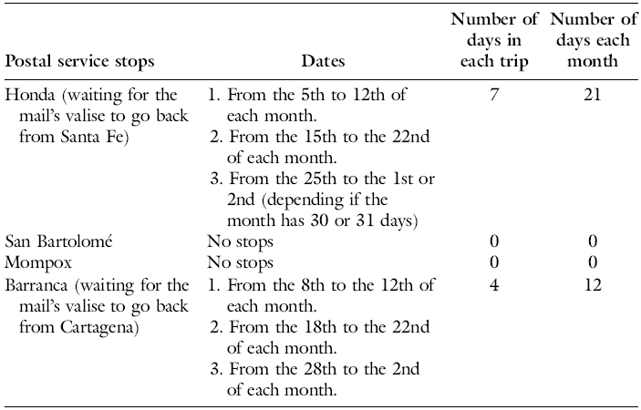
Bogas working in Cartagena’s Carrera were paid at the departing and final point, that is, by Barranca’s and Honda’s offices.Footnote 78 The boats or piraguas (as termed in Honda) or barquetas (as termed in Mompox) were property of the postal service.Footnote 79 Honda’s postal service administration hired between three and four pilots. Each of them made two trips per month and stayed in Honda for approximately 100 days per year (see Table 1).
Salaries paid to pilots and bogas of the Carrera de Cartagena 1783–1795

Source: AGI, Correos, 226B, 226C, 78B, 79A, 79B, 80A, 80B,81A, 81B.
Cartagena’s administration hired two pilots for this carrera until 1791, when it started using three pilots, as the viceroy Ezpeleta decreed to add one trip per month.Footnote 80 Each pilot was in charge of one trip per month, departing on the 10th, 20th, and 30th of each month. They were supposed to take the valises from Honda to Barranca and stay there for 4 days until the valises were taken to Cartagena and then taken back again to Barranca with the newly arrived mail. Then, they took the valises back to Honda. Overall, they stayed for approximately 4 days each month (100 days a year) in Barranca and 100 days in Honda, as shown in the itinerary presented in Table 2.
Itinerary of stops of the postal service

Source: AGI, Correos, 214A.
Although not all bogas worked for these offices, the movements of those who did suggest certain patterns, rhythms, and a degree of predictability that offer valuable insights into the broader behavior of other bogas. Furthermore, the existence of such patterns, and their significance in the formation of commercial, political, and social networks, has recently been emphasized in studies of seafarers and inhabitants of Atlantic port cities. These movements and connections have been key to the construction of imagined communities. However, these questions have yet to be fully explored in the context of colonial riverine landscapes.Footnote 81
Along these lines, Valeria Mantilla-Morales’ recent work presents the compelling idea of complicating our understanding of amphibious culture in New Granada’s Caribbean, inviting us to view the bogas beyond “their roles as racialized laboring bodies in constant itineration, with little to no permanence in time and space.” In her article, she emphasizes the bogas’ attachment to the land and underscores the importance of this relationship in the development and commercial connections around the Cesar and Magdalena River.Footnote 82
Aligned with this idea, the specific case of the bogas navigating the Magdalena River reveals a crucial and often overlooked aspect of their lives: while they were highly mobile, their movements were not erratic or purely transient. On the contrary, these rowers traveled with a degree of predictability and frequently stayed in riverbank settlements for several days. This regularity allowed local inhabitants to anticipate the arrival of particular bogas and estimate how long they would remain. Such periodicity fostered closer social ties between the bogas and the riverine communities. Far from being uprooted, as nineteenth-century travelers and even twentieth-century scholars often assumed, the bogas were deeply embedded in local social networks, both along the river and in places far from their hometowns. In fact, colonial archival records reveal instances of bogas participating in social events and interacting with locals in diverse and meaningful ways.Footnote 83
In port cities, bogas frequented local places of sociability, participated in social gatherings, and enjoyed drinks and conversation. In the evenings, after completing their daily chores, they sought out places to relax. A notable example is Rafael Aguas, a mulato boga from Mompox, who was imprisoned by the alcalde of Honda while attending a child’s funeral at a chichería (tavern) with fellow bogas. Another case is that of Agustín Echevarría, a boga in Mompox, who was caught at a baile de bunde (dance party).Footnote 84
Bogas not only frequented public spaces but also became part of the private sphere of local inhabitants by visiting their homes. One example of this is Jacinto Machado, a boga who was apprehended while on his way to the house of “Taita Veleño,” an older pilot awaiting news of his boat. This movement between public and private spaces highlights how bogas were not isolated figures, but rather integrated into the social and commercial networks of riverine communities.Footnote 85
Visiting female associates, whether lovers or family members, was also an essential part of the bogas’ daily lives. These visits often led to their detention, as such relationships were criminalized. Bogas were frequently accused of engaging in illicit relationships with local women, particularly those that violated spiritual and temporal laws, such as cohabitation without marriage or polygamy. In one instance, Honda’s alcalde detained three bogas arguing that they were “at the door of a house of two women.” The arrest was made because, according to the alcalde, the women’s “calidad and their occupation (selling chicha) did not deserve any trust.” Similarly, one of the bogas was allegedly headed to the house of the woman with whom “he illegally and publicly lives.”Footnote 86
During their stays, bogas attended social gatherings, visiting colleagues, family members, friends, and partners. Even though they were mobile subjects, bogas needed and created networks of support in each riverine town. They built these networks through kinship and camaraderie and in places of sociability such as the chicherias or the houses of the port dwellers.
These relationships, however, were not always friendly and often included conflicts between the villagers and other bogas. Some of the conflicts were related to how the navigation was organized. The boga trade depended on the capacity of a pilot to recruit bogas and to make them strictly follow his orders, not only when traveling, but also during their stays in the fluvial ports. Pilots needed the bogas, for instance, to be on time or to arrange the boats for them. This was based on a hierarchical relationship between pilots and bogas that was usually based on age and blood or fictive kinship. The pilot was usually an older man who had taught the trade to younger bogas, often one of their relatives. This was, then, a relationship of the order of older/younger, master/apprentice, and father/son.
This power dynamic, however, led some bogas to view the pilot as an ambiguous figure. As a result, conflicts often erupted between them and the pilot, who, at times, sought the intervention of municipal authorities to imprison unruly bogas who defied their orders. One such incident involved Gabriel Cabrera, the pilot of the boat Jesús, María, and José, and Ciriaco Gutiérrez, a boga who was imprisoned at Cabrera’s request by the alcalde. Upon his release, Gutiérrez, enraged by the treatment, sought out Cabrera. When he found him at the home of a mutual acquaintance, Gutiérrez confronted the pilot, expressing his anger in racialized terms, calling him a “lavacaras de los blancos” (adulator of whites). The altercation escalated, ultimately ending fatally for the pilot.
This case was resolved thanks to the witnesses, mostly women present at that moment. These testimonies allow us to observe women’s familiarity with the bogas but also the conflictive relations they had with some of them. The alcalde collected many testimonies, among which, there was the declaration from María Manuela Pedrozo, “free woman widow of Juan Antonio Silva,” and the owner of the house where the fight took place. She declared that she knew both bogas well, stressing the familiarity with both of them but also her contempt with the boga Gutiérrez. María Manuela declared that he was pestering her and even “mistreating her body.” Another woman, María Salvadora Leal, declared that Gutiérrez tried to approach her but she was clearly warned: “to abstain from doing it as she was a married woman.”Footnote 87 For local women, bogas’ presence meant familiarity, friendship, love, and support, but also fear, mistreatment, and troubles with the local authorities.
Face-to-face relationships with the locals also included the authorities. If nineteenth-century travelers described bogas from a distant point of view, bogas were all but distant from local authorities and local political life. They maintained face-to-face relationships with members of the cabildos and royal officials. Paying attention to how different authorities referred to the bogas during the criminal cases, certain expressions were frequently found, such as “he was publicly known for” or “he was known as.” In the case of Jacinto Machado, for instance, the alcalde declared he had been after Machado for a long time, as he had pressed charges for concubinage, but it had not been possible to imprison him as “he had spies” who had alerted Machado.Footnote 88 In other cases, it is possible to find more than one conflict between the same cabildo official and the same boga, for instance, between the alcalde de barrio Lorenzo Recio and the pilot Cosme Aleman in 1794 and 1799.Footnote 89
Bogas’ relationships with the authorities often led to direct conflict. However, due to the specific organization of their work, they also forged relationships of interdependence and clientelism with other local and regional authorities, including members of local trade elites and officials who depended on their services. These latter dynamics better describe bogas’ relations with their bosses, revealing a complex system where mutual dependence shaped their interactions, often blurring the lines between subordination and collaboration.
Bogas’ perceptions of the river, along with its human and nonhuman actors, become even clearer when contrasted with José María Samper’s perspective on the Magdalena River. In 1855, this Colombian writer, lawyer, and politician embarked on a journey abroad. Nostalgic to leave his native Honda, he described the journey down the Magdalena River as entering into a land of “infinite solitudes, burning deserts, and the monotonous uniformity of the lower Magdalena… becoming [the river] more ungrateful due to the absolute loneliness of its twists and turns.”Footnote 90 However, for the bogas, the river was anything but a place of solitude and loneliness. For them, the fluvial landscape was rich with meaning—it was a realm of love, friendship, camaraderie, family, sustenance, joy, and even death.
Conclusions
In a very unique space of interethnic relationships, these men of African and African-Indigenous ancestry acquired familiarity with the Magdalena River’s fluvial geography and produced and spread knowledge about it and its navigation. Bogas became experts on the daily dynamics of water; the depth of the rivers, channels, and marshes; their seasonal variations and rainfall regimes; and the general characteristics of the riverbed, flora, and fauna. In contrast with European and Creole views on the fluvial landscape of the Magdalena River, where feelings of distance, pessimism, fear, and strangeness were predominant, bogas found familiarity, opportunity, food, and health. Motivated by their needs and imagination, and facilitated by the organization of their work, which allowed for a certain degree of predictability, bogas created extensive support networks along the river and its tributaries, channels, and swamps. Through the construction of this network of social relationships, bogas on the Magdalena gave meaning to the fluvial geography of the New Granada.
Lauren Benton invited historians to recognize and explore the spatial dimensions of the early modern empires. In particular, Benton signaled the central place of rivers in the empire-building process, produced as “uneven legal geographies” and lawless places. Rivers, Benton argues, were central in the claiming of sovereignty, the exerting of authority, and in the political and spatial imagination of European countries. However, rivers produced anxiety for Europeans, as they had to trust in non-Christians guides to explore and travel them. The Magdalena River, in this sense, constitutes a thought-provoking case study, as it played an ambiguous role for Spanish and creole authorities. It fits Benton’s analysis for Europeans, as it was a place of anxiety, fear, distress, and even death, but it was also a place of opportunity. The river constituted the backbone of New Granada while at the same time being mostly inhabited and controlled by people of full or partial African descent. In this sense, it was perceived as a dangerous place inhabited and managed by “savage” people; a very needed but unfamiliar space.
On the contrary, for Africans and their descendants, the river became a familiar place, where life, love, labor, friendship, conflict, and death occurred. In this sense, the history of the Magdalena River and its rowers is the history of the interplay between geographies of domination and Black geographies. By centering the boga along the Magdalena River, this study provides evidence of how the spatial dimensions of the early modern empires involved interactions, struggles, and negotiations between white masculine European and Black geographies. In this way, it can illuminate the histories of other Spanish–American fluvial spaces such as the Mississippi, Orinoco, Chagres, Zulia, and Amazon rivers and their role in the construction of race, sovereignty, and the making of the Spanish Empire.Footnote 91
Acknowledgements
This article has been in preparation for several years, a process delayed by the pandemic and the vicissitudes of life. Its completion was possible thanks to the support of many colleagues who accompanied its development and enriched it with their comments. I am especially grateful to Alejandro Camargo, Eloisa Berman, Yesenia Barragán, Bethan Fisk, Pablo Gómez, the participants in the workshop Captive Mobilities: Slavery, Freedom, and Knowledge Production in Latin America and Beyond at the University of Bristol, and to the Transdisciplinary Network on Environmental Studies (Pontificia Universidad Javeriana). I also wish to thank the two anonymous reviewers for their generous and insightful feedback, as well as the editorial team of The Americas for their invaluable support in bringing this article to publication.
I am an anthropologist and historian from Universidad de los Andes (Bogotá, Colombia), with a M.A. in History from the same university and a Ph.D. in History from Johns Hopkins University. I am a faculty member in the Department of History and Geography at Pontificia Universidad Javeriana (Bogotá), where I coordinate the Master’s program in Afro-Colombian Studies. My research explores race, politics, and geography in colonial Latin America, with an emphasis on the African diaspora and the Magdalena River. I am the author of a book on mestizaje and colonial governance in eighteenth-century New Granada, as well as of articles, including “Free People of African Descent and Jurisdictional Politics in Eighteenth-Century New Granada.”


 Open access