

Contemporary studies of archaeological landscapes are preoccupied—some would say obsessed—with investigations of meaning (Anschuetz et al. Reference Anschuetz, Wilshusen and Scheick2001; Ashmore Reference Ashmore2002, Reference Ashmore, Meskell and Preucel2004; David and Thomas Reference David, Thomas, David and Thomas2008; Johnson Reference Johnson2007; Knapp and Ashmore Reference Knapp, Ashmore, Knapp and Ashmore1999:1–2; Layton and Ucko Reference Layton, Ucko, Ucko and Layton1999). How can archaeologists identify meaningful places in the past? How did people in the past conceptualize their surroundings, and how do those views differ from ours today? What did the landscape symbolize to those who pondered it centuries ago? And how can we identify cultural meanings that have been layered upon the land through time?
Over the past three decades, anthropologists have employed a variety of labels to characterize the intersection of landscape and meaning, including cultural landscapes (Evans Reference Evans1985; Ferguson and Anyon Reference Ferguson, Anyon and Weinstein2001; Strang Reference Strang1997), taskscapes (Ingold Reference Ingold1993), sacred landscapes (Ashmore Reference Ashmore and Díaz2010), ceremonial landscapes (Dillehay Reference Dillehay1990), places that matter (Orser and Funari Reference Orser and Funari2001), landscapes of memory (Schama Reference Schama1995), and ritual landscapes (Moore Reference Moore2004). These studies, which I group under the umbrella term Landscapes of Meaning, have collectively transformed the way archaeologists investigate the landscapes of the past. Broadly defined, Landscapes of Meaning (LoM) are places that play a role in maintaining the cultural identity of a particular social group. More precisely, they are relatively contiguous locales, or places similar to one another, that a community has endowed with cultural significance. LoM are often integral to the ideology, ritual practice, history, identity, cosmology, or religion of a social group. In archaeology, LoM approaches avoid rigidly economistic, subsistence-based analyses. Instead, LoM studies articulate alternative views by attempting to discern emic perceptions of the land, often giving voice to contemporary indigenous perspectives in the process (Ashmore Reference Ashmore, Meskell and Preucel2004:265–266).
Roughly coincident with the development of LoM studies, archaeology has witnessed a similar flourishing of research performed jointly with heritage stakeholders, descendant communities, and traditionally associated groups over the past 30 years (Silliman and Ferguson Reference Silliman, Ferguson, Ashmore, Lippert and Mills2010). Like LoM, these studies employ a variety of terms to characterize their inclusive methodologies, including community and community-based archaeology (Atalay Reference Atalay2012), applied archaeology (Gnecco and Hernández Reference Gnecco and Hernández2008:454–462), indigenous archaeology (Watkins Reference Watkins2000), public archaeology (Merriman Reference Merriman2004), cosmopolitan archaeologies (Meskell Reference Meskell2009), and collaborative archaeology (Colwell-Chanthaphonh and Ferguson Reference Colwell-Chanthaphonh and Ferguson2008; Kerber Reference Kerber2006; Silliman Reference Silliman2008). For simplicity's sake, I collapse these approaches under another big-tent label, collaborative archaeologies. While archaeologists have collaborated with heritage stakeholders and descendant communities in various forms throughout the twentieth century, explicit discussions of collaborative archaeology have emerged over the past quarter-century and expanded exponentially in recent years. In the United States, federal laws including the National Historic Preservation Act (NHPA), the National Environmental Policy Act (NEPA), and the Native American Graves Protection and Repatriation Act (NAGPRA) helped to usher in this new era of collaboration. NAGPRA in particular forced archaeologists to examine the connections between modern-day native communities and the archaeological past through its mandate to determine cultural affiliation (Fowles Reference Fowles2010:457; Liebmann Reference Liebmann, Liebmann and Rizvi2008:75). It also opened up new lines of communication between archaeologists and native communities, fostering increased consultation and collaborative research.
In the Southwest US, collaborative archaeologies and LoM approaches have converged over the past two decades to form what Fowles (Reference Fowles2010:454) terms “the Southwest School of Landscape Archaeology,” which consists of a distinctive approach arising “out of a newly intensified engagement with the native philosophical tradition of the Pueblos and other local groups.” A commitment to serious and sustained engagement with contemporary descendant communities, native epistemology, and indigenous knowledge guides these studies. Drawing upon contemporary indigenous perspectives on land, place, history, memory, and cultural affiliation to interpret the archaeological record, the Southwest School often employs the direct historical approach to understand ancient landscapes (Fowles Reference Fowles2010:459). These studies fuse archaeology and ethnographic research, building upon the perspectives of contemporary Native American research partners and twentieth-century ethnography (e.g., Anschuetz Reference Anschuetz, Hegmon and Eiselt2005, Reference Anschuetz, Anscheutz and Merlan2007; Anschuetz et al. Reference Anschuetz, Wilshusen and Scheick2001; Colwell-Chanthaphonh and Ferguson Reference Colwell-Chanthaphonh and Ferguson2004; Reference Colwell-Chanthaphonh and Ferguson2006; Darling Reference Darling, Snead, Erickson and Darling2009; Ferguson and Anyon Reference Ferguson, Anyon and Weinstein2001; Ferguson and Colwell-Chanthaphonh Reference Ferguson and Colwell-Chanthaphonh2006; Fowles Reference Fowles2009, Reference Fowles2013; Ortman Reference Ortman2012; Snead Reference Snead, Lucero and Fash2006, Reference Snead2008, Reference Snead, Snead, Erickson and Darling2009).
Landscapes of Meaning in the American Southwest: Contributions and Critiques
The studies that comprise the Southwest School have transformed the way archaeologists write about the archaeological landscapes of the Southwest US. In contrast to functionalist interpretations of Southwestern landscapes (e.g., Walsh Reference Walsh1998; Wimberly and Rodgers Reference Wimberly and Rogers1977), this new school does not conceive of landscapes solely as assemblages of resources to be exploited, nor as a neutral backdrop for human action. Instead, Southwestern archaeologists working under the LoM paradigm highlight the cultural values, symbolic meanings, and social histories evoked by landscapes. Whereas a previous generation sought to uncover general patterns of human behavior, the Southwest School examines specific histories of particular Native American groups. Whereas previous approaches advocated purely etic stances, the Southwest School strives for emic understandings. Moreover, whereas past studies of Southwestern landscapes envisioned catchment areas populated by faceless agents, the Southwest School envisions specific river valleys, familiar mesas, and named canyons inhabited by identifiable ancestral clans and tribes.
The Southwest School strives to understand the present as well as the past, documenting the perspectives of present-day indigenous communities as well as the lands in which their ancestors dwelled. Additionally, its practitioners focus on ethical issues by highlighting the ways in which previous approaches alienated descendant communities from their archaeological pasts through a commitment to logical positivism and the rejection of ideographic reasoning (Trigger Reference Trigger1996:312–313). However, perhaps the most important contribution of the Southwest School has been to open archaeologists’ eyes to the multiplicity of meanings embedded in landscapes. Indigenous research partners provide alternatives to the ostensibly objective “common sense” interpretations frequently offered by (Western) rational economic models, which view landscapes primarily as assemblages of resources to be exploited. In this way, the Southwest School has pointed Southwestern archaeologists in important new directions, opening innovative avenues for research while proposing novel interpretations of the past.
Despite these advances, the studies that comprise the Southwest School (and LoM approaches more generally) are not immune to criticism. Concerning kindred landscape studies in other parts of the world, detractors launch accusations of unsubstantiated speculation (Smith Reference Smith2003:225–226), calling them “misguided,” “highly questionable,” and “problematic” (Fleming Reference Fleming2006:267). Within the Southwest US, LoM studies are particularly susceptible to charges of tautology, homogenization of the past and present, and the production of ahistorical interpretations. Many of these criticisms stem from the use of the direct historical approach to interpret the past. As Snead notes, “one problem of landscaped archaeologies based in particular ethnographic traditions is that they may tell us only what we already know” (2008:23–24). By conflating the landscapes of the ethnographic present with those of the archaeological past, studies of the Southwest School potentially collapse the temporal variability that archaeologists seek to discover (Stahl Reference Stahl1993:246). In other words, these studies can paint pictures of past LoM that mirror the landscapes of today.
In addition to gambling with tautology, the use of direct historical analogy risks propagating a common myth regarding the nature of indigenous societies: that native cultures are essentially static and unchanging (McGhee Reference McGhee2008:587). By focusing on continuities between the archaeological past and present-day Indian tribes, studies of the Southwest School can inadvertently perpetuate the myth of timeless indigenous cultures. When archaeologists assume that Ancestral Pueblo peoples of the past held a worldview similar to that of modern Pueblo people today, they emphasize continuities over possible differences (Snead Reference Snead, Snead, Erickson and Darling2009:50). And by presuming that native perceptions in the present echo those of their ancestors, these studies can unwittingly promote a concept of unchanging indigenous worldviews persisting through time. This line of reasoning evokes images of indigenous peoples as static and tradition-bound in opposition to the dynamic, evolving cultures of non-natives. In turn, these binary notions produce ahistorical depictions of timeless indigenous landscapes. The resulting homogenization of past and present is not merely an academic issue. Notions of fixed and invariable indigenous culture have political and legal consequences for Native American peoples in the twenty-first century (Liebmann Reference Liebmann, Liebmann and Rizvi2008).
I do not mean to suggest that shared meanings cannot persist over long expanses of time. Ancestral Pueblo peoples of the distant past may indeed have shared the worldviews of their descendants today. However, archaeologists should demonstrate this continuity using the archaeological record and not assume it a priori.
The interpretations of the Southwest School raise epistemological issues as well. Do these studies illuminate the present or the past? Starting as they do from the observations of contemporary collaborators (or the “ethnographic present”), is this archaeology or ethnogeography? Some studies of the Southwest School explicitly do not set out to study the past, but rather seek to elucidate how the past has meaning for today. Others address both the present and the past simultaneously. Yet critics contend that such an approach documents modern-day perceptions, not the beliefs of a bygone era. At the core, these issues stem from differing notions regarding the nature of archaeology and the nature of the past. Is the archaeological past something to be empirically proven or humanistically interpreted? Is the past dead and gone or is it continually reproduced in the present? As Ashmore notes, “archaeologists with diverse epistemic perspectives come into conflict about the legitimate and appropriate ways of knowing the past, especially when the aim is to infer ancient meaning” (2008:168).
Despite these criticisms, archaeologists should not reject the approaches advocated by the Southwest School of Landscape Archaeology quite yet. Rather, these critiques are evidence of a maturing field. The contributions of the Southwest School include new methodological approaches and innovative propositions about the past, and draw attention to previously overlooked aspects of archaeological landscapes. While the perils of essentialism and tautology loom over these studies, archaeologists should be wary of throwing out the tot with the tub water. In order to maintain relevance, however, collaborative studies of archaeological landscapes need to address critiques of timelessness and circular reasoning.
From Landscapes of Meaning to Landscapes of Signification
The root cause of the challenges facing the Southwest School and similar LoM studies stems not solely from their use of analogy to interpret past landscapes. Nor does it derive from a lack of epistemological rigor. In my opinion, the primary challenges to LoM studies arise from incomplete definitions of meaning.
What do archaeologists mean by “meaning”? To say that landscapes are meaningful implies that they are communicative. That is, in order for landscapes to convey meaning, they must employ signs that stand for something else (Preucel and Bauer Reference Preucel and Bauer2001). More precisely, semiotic anthropologists would say that these signs stand for something in respect to someone (Silverstein Reference Silverstein, Basso and Selby1976:12). At the most basic level, semiotic anthropologists distinguish three modes by which signs communicate meaning: iconicity, indexicality, and symbolism.Footnote 1 Icons communicate meaning through resemblance and similarity (maps are a common example). Indexes communicate through contextual connections, by “pointing to” their meanings (a weathervane, for example, indexes the direction of the wind). Symbols communicate through conventional associations (most words are prototypical examples). That is, symbolic meanings are arbitrary and agreed upon by members of a social group (Mertz Reference Mertz2007:338–539; Preucel Reference Preucel2006:56).
LoM studies typically focus on the arbitrary, culturally specific meanings of ancient landscapes—the symbolic meanings, as semiotic anthropologists would say. These meanings may relate to rituals, myths, historical events, religious beliefs, or any number of other culturally specific traits. However, one unintended consequence of this focus on symbolic meaning is the production of synchronic, seemingly static interpretations. By linking contemporary symbolic meanings directly to the ancient past, LoM studies largely neglect issues of temporality and the transformation of meaning. How did these meanings come into being? How did they change over time? How might contemporary meanings differ from those in the past?
Thankfully, symbolism is not the only type of meaning encoded in landscapes. Archaeologists can identify indexical properties in the archaeological record as well. Indexical signs hinge on their specific contexts to transmit meaning. They employ spatial and/or temporal connections to indicate significance. For example, when we use the width of tree rings to infer annual precipitation in the past, narrower rings index—or point to—a time of lesser rainfall. But a single tree ring, isolated from its concentric colleagues, tells us nothing about seasonal changes in precipitation when divorced from its context. Symbolic meanings, by comparison, use abstract, context-free associations. For a discipline with as long and storied an obsession with context as archaeology, an explicit focus on indexical signs only makes sense.
Rather than concentrating primarily upon abstract, atemporal, symbolic meanings frozen in the landscape (as current LoM studies commonly do), archaeologists should also examine the processes and conditions that give rise to those meanings. I refer to this shift in focus as the Landscapes of Signification (LoS) approach, and it hinges upon the connections between symbolic and indexical modes of meaning in the archaeological record. The LoS approach is inspired by historical shifts in cultural and linguistic anthropology over the past 40 years. The transition from an LoM to an LoS approach mirrors the transition from symbolic to semiotic methodologies in sociolinguistic anthropology (Mertz Reference Mertz2007:340). The former, with roots in the semiology of Ferdinand de Saussure, is embodied most prominently in the writings of Claude Levi-Strauss, Victor Turner, Mary Douglass, and Clifford Geertz. The latter, in contrast, is inspired by the semiotics of C. S. Peirce and embodied in the work of Michael Silverstein, Milton Singer, and Webb Keane.
Caveat lector: While semiotic anthropology inspired the LoS approach, my use of the terms meaning, signification, symbol, and index do not adhere strictly to those employed by C. S. Peirce and his acolytes (Peirce Reference Peirce1992, Reference Peirce1998). Semioticians may object to my diluted use of these terms (not to mention my wholesale neglect of many other aspects of Peirce's pragmatic philosophy). While the esoteric metalanguage of semiotics may be necessary for linguistic analysis, its byzantine jargon has earned a reputation as challenging at best and impenetrable at worst, particularly for archaeologists who have not been initiated into the semiotic tribe. For this reason, I employ simplified terminology inspired by Peirce's writings here. With these warnings in mind, the rest of this article attempts to demonstrate the LoS approach through a case study focused upon the archaeological landscapes of northern New Mexico.
Case Study: Jemez Pueblo and the Valles Caldera
At Jemez Pueblo in northern New Mexico (Figure 1), contemporary tribal members maintain an oral tradition that recounts their ancestors’ migration into the region (Ellis Reference Ellis1956; Martin Reference Martin2003:12; Parsons Reference Parsons1925:137–138; Sando Reference Sando1982:4–13). Over the past 18 years, I have heard this story repeated in official settings by the Governor of the Pueblo, in informal settings in the homes of friends, and from tribal collaborators while conducting archaeological research. What follows is my attempt to synthesize the various versions of this tale that I have heard over the years with those recorded by Elsie Clews Parsons in the 1920s, Florence Hawley Ellis in the 1950s, and Joe Sando in the 1980s:
In the long ago time of the emergence, the Hemish (Jemez) left the underworld. During a period of parching drought, the Cacique informed the Spirits of the Hemish people's desire to find a new home. The Spirits told the people that they would find their lands at the place marked by the sign of the sacred eagle. Thus began an epic, centuries-long migration across deserts, through canyons, and over mountain ranges. After many generations of searching, the Hemish arrived at the base of a large mountain. When the people looked up at the peak looming above, they saw the silhouette of an eagle standing guard over them ( Figure 2 ). Here was the sign that the Creator had long ago promised. The Hemish had reached the Place of the Eagle. In the generations that followed, the Hemish fanned out across the sprawling mesatops and canyons south of the mountain, building new villages and planting their corn. There they lived good lives in the shadow of the mountain peak, with the sacred eagle watching over them.
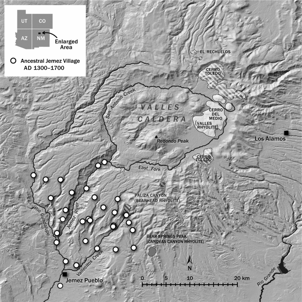
The ancestral Jemez province and Jemez Mountains obsidian sources.
(left) View of Wâavēmâ/Redondo Peak from Jemez Pueblo looking north; (right) Official Seal of the Pueblo of Jemez.
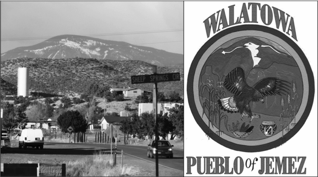
The Jemez people still live in the shadow of that same mountain peak today, and it is still adorned with the silhouette of an eagle. Standing in the plaza at Walatowa (Jemez Pueblo), one can see that the summit rises over the flat roofs on the north side of the pueblo. Modern maps label this mountain Redondo Peak, the most prominent landform in the Valles Caldera. To the Jemez people it is known by other, older names: Sey-tokkanu, “the place of the eagle;” and more commonly, Wâavēmâ ky’ôkwa (“Want for Nothing Peak”) or simply Wâavēmâ for short. (The term Wâavēmâ refers to both Redondo Peak specifically and the Valles Caldera region more generally.) The prominent depiction of the Wâavēmâ eagle on the official seal of the Jemez Pueblo Tribe attests to its significance to the contemporary Jemez people today.
Geologically speaking, Redondo Peak is a resurgent lava dome created in the aftermath of a volcanic eruption. Today it stands within a collapsed crater known as the Valles Caldera, a 22 km wide basin of grass-covered meadows interlaced by clear mountain streams. (The meadows, termed valles by the Spaniards who stumbled into this region in the sixteenth century, give the locale its name.) Ringing the edge of the bowl are high mountain ridges covered in thick Ponderosa pine forests. The emerald hues of the Valles Caldera stand in stark contrast with the dusty tans and reds of the desert mesas that form its flanks. Writer and conservationist William deBuys (Reference DeBuys2006:9–10) describes the majesty of this landscape, writing from the perspective of someone crossing into the Caldera over its southern rim:
the space before you bursts outward into a giant, grass-carpeted mountain bowl. The bottom of the bowl, unbroken grassland with a river meandering down its center, is easily four miles across, to say nothing of its forested sides . . . so unexpected [is] the sudden abundance of space and light and visual detail, that you are left wordless. Or you swear, invoking all the impact four letters can provide. Then you fall silent . . . A seemingly misplaced prairie lies before you, a tawny sea of grass miles deep and broad, which has been dropped into the top of a heavily forested mountain range.
Beneath this prairie, a fitful geothermal world simmers and steams, its waters bubbling out into hot springs that mist the hillsides. Hawks, owls, and peregrine falcons prowl the skies, while an enormous herd of elk grazes the lush valleys. In order to preserve the unique geology, ecological diversity, and cultural importance of this place, the federal government purchased 89,000 acres of land in and around the Valles Caldera in the year 2000, including Redondo Peak. Fifteen years later, the Valles Caldera National Preserve (VCNP) was added to the National Park system.
Given the astonishing natural beauty of the Valles Caldera, it is no wonder that the people of Jemez Pueblo hold Wâavēmâ in particular esteem. Jemez people use the dormant volcano for hunting, collecting plants and herbs, gathering minerals, pasturing livestock, and for ceremonial and spiritual activities, including pilgrimage retreats and initiations. Their most important shrine—a place where humans communicate with other-than-human beings (i.e., “spirits”)—adorns the top of Redondo Peak. Ethnographic studies amply describe the symbolic associations that the Jemez affix to Wâavēmâ today (Ellis Reference Ellis1956, Reference Ellis1964; Parsons Reference Parsons1925; Sando Reference Sando1982; Weslowski Reference Weslowski, Baker and Winter1981). As Anschuetz notes, “the Valles Caldera landscape simultaneously possesses multiple levels of significance informed by Jemez Pueblo oral traditions of emergence and migration” (2007:144). In addition to its role in their migration narrative, this landscape evokes the concepts of life, eternity, sustenance, fertility, and power to the Jemez people.
In the Jemez worldview, the Valles Caldera is not merely a unique environment or even just a special place. Wâavēmâ exists as a living entity and the source of life. Like a mother, Wâavēmâ gives life to newborns and sustains its Jemez children on earth. Parsons's ethnographic informants identified Wâavēmâ as “the place from which the people came and whence the newborn still come” (1925:125). The Jemez shrine on Redondo Peak forms a symbolic connection to the Underworld womb from which the people first emerged (Parsons Reference Parsons1939:309). The Jemez River, whose headwaters originate in the Valles Caldera's sacred basin, acts as the umbilical cord connecting Jemez Pueblo to Wâavēmâ. The waters flowing out of the Valles Caldera sustain the Jemez people as a mother sustains her offspring with her blood and milk. Wâavēmâ’s waters flow through the Pueblo of Jemez, irrigating Jemez fields and nourishing Jemez bodies, Jemez crops, and the Jemez community. Thus, Wâavēmâ is the source of life not just metaphorically or mythically, but quite literally. At the opposite end of the life course, the spirits of Jemez persons return to the Valles Caldera after shedding their earthly skins. Tribal members liken Wâavēmâ to “Jemez heaven. That's the place where the ancestors live” (Jemez tribal member, personal communication 2011). Wâavēmâ embodies eternal life for the Jemez as the alpha and the omega, the beginning and the end. Its equivalent in Judeo-Christian mythology would be the Garden of Eden, Heaven, and the Holy Spirit all rolled into one: the domain where life began, from which life springs forth today, and to which the deceased eventually return.
The Valles Caldera also provides medicinal plants and animals to the Jemez, and as such carries associations of fertility and fecundity. Members of Jemez religious societies gather plants and herbs that grow locally only within the Valles Caldera (Weslowski Reference Weslowski, Baker and Winter1981:112–124). Animals hunted within the confines of the Valles Caldera aid in medicine and healing, particularly bears and mountain lions (Parsons Reference Parsons1925:62). Turkeys, also abundant in the vicinity, are affiliated with clouds and cloud spirits (dyasa). But most important of all are the eagles captured at Wâavēmâ. In addition to the eagle's iconic association with Redondo Peak and the Jemez migration story, eagles are also linked to the water cycle. Eagles symbolize “clouds, rain and snow, and lightning with its attendant fertility-bringing aspects” (Tyler Reference Tyler1991:39–40).
All these various associations—life, sustenance, fertility, and power—converge in one of the singular resources of Wâavēmâ: superior-quality obsidian. In the northeast quadrant of the Valles Caldera, a literal mountain of obsidian rises up from the grassy plain. Known to the Jemez as Gee way kia shin (Shining Rock Hill, also known as Cerro del Medio), its sheer bulk makes this the largest obsidian source by volume in the Southwest US (Shackley Reference Shackley2005:72, see Figure 1). Jemez people seek stone from Gee way kia shin specifically for use in prayer and religious ceremonies (Weslowski Reference Weslowski, Baker and Winter1981:115). Traditional Pueblo belief holds that obsidian “is formed by lightning striking the ground” (Ford Reference Ford1992:122). Lightning, in turn, is believed to endow the land it strikes with fertility (Tyler Reference Tyler1964:236). Through this link to lightning, Jemez people associate obsidian with fertility, rainfall, and the life-giving powers of Wâavēmâ.
The Waavema Archaeological Research Project
In 2010, the Cultural Resource Advisory Committee at Jemez Pueblo asked me to collaborate on an archaeological research project focused on the Valles Caldera. Tribal officials wanted to investigate their ancestral interactions with this landscape in order to provide federal land managers with information that could aid in the preservation and management of resources in and around Wâavēmâ. In the words of Tom Lucero, a member of the Cultural Resource Advisory Committee, they wanted to use science to show how their ancestors used the Caldera. I enthusiastically accepted their invitation, and we dubbed our collaboration the Wâavēmâ Archaeological Research Project (WARP).
When we began to plan an appropriate research methodology, we immediately faced a substantial obstacle: the archaeological record within the Valles Caldera is comparatively sparse, and what exists lacks a clear ethnic signature. With a narrow assemblage consisting primarily of obsidian debitage, hammerstones, and chipped stone tools (Anschuetz Reference Anschuetz, Anscheutz and Merlan2007:49; Steffen Reference Steffen2017), the archaeology of this landscape remains stubbornly mute about the identities of those who frequented its grassy meadows. Given this sparse archaeological record, the Valles Caldera would seem a prototypical place to employ a collaborative LoM approach along the lines of those previously produced by the Southwest School. Such an approach might employ contemporary Jemez beliefs to infer that the Wâavēmâ landscape symbolized life, fertility, sustenance, and power to the ancestral Jemez people of the archaeological past. That is, we might assume that the people who occupied this region from AD 1300 to 1700 shared the associations of their descendants, based on analogies with contemporary ethnographic records. Such an approach has the advantage of drawing attention to meanings of this landscape that traditional, artifact-based studies focused solely upon the archaeological record of the Valles Caldera would overlook.
However, if we content ourselves with interpretations of the Valles Caldera landscape based solely upon contemporary ethnographic insights (a process ethnohistorians refer to as “upstreaming”), we cannot help but construct a past landscape in the image of the present. We will never discern the differences in cultural meanings that may have characterized the use of Wâavēmâ in the past, nor will we be able to investigate the diachronic development of meanings that have come to be associated with this landscape. Yet the use of analogy does not necessarily condemn us to tautological renderings of the archaeological past. Typically, studies in the Southwest School have focused on bolstering the source-side of analogies (the selection of analogues used to infer meaning). Less attention has been paid to subject-side concerns, or “how we apply analogical models to archaeological contexts” (Stahl Reference Stahl1993:236). But as Stahl (Reference Stahl1993) and Wylie (Reference Wylie2002) note, archaeologists can improve our uses of analogy through attention to the data we employ on both the source-side and subject-side of our analogies. In other words, the identification of direct historical analogies should mark the beginning of the interpretive process, not the end. Once these ethnographic analogues are identified, we need to address processes of signification—the practices and events of the past that gave rise to the symbolic meanings of today. Rather than simply identifying symbolic meanings through analogy, we need to investigate how those meanings came to be. In the case of the Jemez relationship with the Valles Caldera, we need to uncover the past processes that affected contemporary associations of life, fertility, sustenance, and power. One way to investigate these processes of signification is through the indexical properties of the archaeological record.
A “Landscapes of Signification” Approach to Wâavēmâ
The Valles Caldera sits at elevations higher than 2,500 m above sea level and enjoys less than 90 frost-free days per year, rendering long-term maize agriculture unsustainable within the boundaries of the Caldera itself. As a result, ancestral Jemez people chose not to construct their characteristic plaza-oriented pueblos within the confines of Wâavēmâ. Instead, they preferred to inhabit lower elevations, building more than 35 large villages (> 50 rooms) on the dormant volcano's southwestern flanks between AD 1300 and 1700 (see Figure 1).Footnote 2 When the first Europeans entered this region in AD 1541, the occupants of these villages spoke a common language (Towa) and identified themselves as ethnically “Hemes,” which the Spaniards later transliterated as Jemez (Liebmann Reference Liebmann2012:222). They also shared a penchant for the same characteristic pottery, favoring black organic matte-paint designs applied over a chalky, oyster-white slip. Known as Jemez Black-on-white, this distinctive style appears in the ceramic assemblage of archaeological sites throughout the region (Liebmann Reference Liebmann2012:129–131). In fact, the primary defining feature of prehispanic ancestral Jemez sites is the presence of Jemez Black-on-white pottery in high proportions, typically > 30% of the total assemblage (Elliott Reference Elliott1986:1; Liebmann Reference Liebmann2012:129). Because the archaeological record within the Valles Caldera does not lend itself to straightforward ethnic identifications, the WARP turned to these unambiguously Jemez-affiliated sites for indications of ancestral Jemez interactions with Wâavēmâ.
The middens at ancestral Jemez sites brim not only with Jemez Black-on-white pottery, but also with lithic debitage. Chipped chert, basalt, and obsidian flakes abound, unsurprisingly as the Jemez Mountains are a well-known source of lithic raw material in the Southwest US. But it is the obsidian in particular that forms the indexical link between ancestral Jemez pueblos and the Valles Caldera. Five primary sources of obsidian issue from peaks and domes in and around the Valles Caldera, with one additional minor source documented for the first time in the WARP analysis (Baugh and Nelson Reference Baugh and Nelson1987; Glascock et al. Reference Glascock, Kunselman and Wolfman1999; Liebmann et al. Reference Liebmann, Preucel, Aguilar, Douglass and Graves2017:147–149; Shackley Reference Shackley2005:64–74; Shackley et al. Reference Shackley, Goff and Dolan2016) [see Figure 1]. All these obsidian sources exhibit unique trace element compositions, each of which can be differentiated using X-ray fluorescence (XRF) spectrometry (Table 1). The elemental signatures of obsidian derived from these sources thus index (or point to) their origins in particular areas of the landscape.
Element Concentrations for Obsidian Sources in the Jemez Mountains, New Mexico.
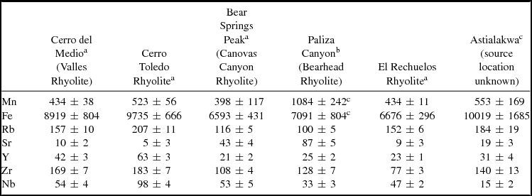
Note: All concentration values reported in parts per million.
a Shackley (Reference Shackley2005:199–200).
b Shackley and others (Reference Shackley, Goff and Dolan2016:59), except where noted.
c WARP pXRF analysis.
Not all of these sources are useful for determining ancestral Jemez interactions with the Valles Caldera, however. Obsidian from sources outside of the Valles Caldera proper (El Rechuelos Rhyolite, Cerro Toledo Rhyolite, Bear Springs Peak/Canovas Canyon Rhyolite, and Paliza Canyon/Bearhead Rhyolite) erode into adjacent river drainages, so flintknappers in the past could have harvested obsidian originating from these sources at a variety of locations throughout the Middle Rio Grande Basin. In fact, nodules deriving from some of these sources occur in river gravels as far away as Chihuahua, Mexico, more than 540 km (340 miles) to the south (Shackley Reference Shackley2005:74). The presence of obsidian from these extra-Caldera sources at ancestral Jemez sites thus offers no conclusive evidence regarding flintknappers’ interactions with the Valles Caldera in the past, or the meanings of this landscape to ancestral Jemez people.
The Cerro del Medio obsidian source (also known as Valles Rhyolite) tells a different story, however. This source protrudes from the eastern basin of the Valles Caldera within the bottom of the giant, grass-lined bowl at Gee way kia shin. Millions of tons of artifact-quality obsidian constitute this rhyolitic dome (Shackley Reference Shackley2005:72). Most importantly for the present study, Cerro del Medio obsidian is not found in secondary contexts. Cerro del Medio obsidian “does not erode outside the Caldera, and had to be originally procured in the Caldera proper” (Arakawa et al. Reference Arakawa, Ortman, Shackley and Duff2011:784). This unique quality establishes an indexical link between artifacts made of Cerro del Medio obsidian and the Valles Caldera landscape itself. To make an artifact from Cerro del Medio obsidian, someone has to physically travel through the Valles Caldera landscape. This means we can use artifacts made of Cerro del Medio obsidian found at ancestral Jemez pueblos as a proxy for their inhabitants’ interactions with the Valles Caldera in the past.
Sampling and Methodology. To assess the intensity and degree of ancestral Jemez interactions with the Valles Caldera, WARP quantified the amount of Cerro del Medio obsidian at 31 ancestral Jemez sites. These 31 sites include nearly all of the large pueblos of the Jemez Province (defined by Michael Elliott as archaeological villages containing 50 rooms or more), with occupations spanning the period from AD 1300 to 1700 (Elliott Reference Elliott1986:178–181).Footnote 3 WARP analyzed 2,222 obsidian artifacts recovered from surface midden contexts at these villages. Sample sizes ranged from 15 to 170 artifacts per site, with an average of 65 per site (Table 2). Sample sizes under 50 artifacts per site resulted from limited surface visibility and/or a lack of additional chipped stone in surface contexts. We collected from midden contexts within 30 meters of architectural remains at each site, collecting from as many middens as possible to maximize the context diversity of each site sample.
Obsidian Samples Analyzed by X-Ray Fluorescence.
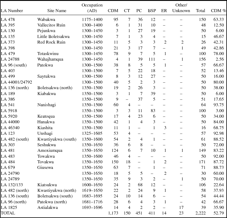
Note: CDM = Cerro del Medio (Valles Rhyolite); CT = Cerro Toledo Rhyolite; BSP = Bear Springs Peak (Canovas Canyon Rhyolite); PC = Paliza Canyon (Bearhead Rhyolite); ER = El Rechuelos Rhyolite.
The analyzed artifacts consist of unmodified primary and secondary obsidian flakes, debitage, and shatter. We deliberately selected artifacts from the early stages of production to better represent patterns of acquisition and minimize the impacts of trade on our sample, rather than analyzing finished tools such as projectile points, scrapers, and knives. While it is theoretically possible that raw materials could have made their way to these villages through exchange, the close proximity of ancestral Jemez sites to the Valles Caldera makes the likelihood of down-the-line trade of unworked Cerro del Medio obsidian into these pueblos unlikely. Such trade would have required people who lived farther away from the source than the Jemez to acquire the obsidian and then trade it to the Jemez, contradicting the assumptions of traditional distance-decay models. Furthermore, the ceramic record suggests that ancestral Jemez peoples engaged in minimal trade with outside groups prior to the seventeenth century (Liebmann Reference Liebmann2012:156). The most parsimonious reconstruction of the lithic reduction sequence thus suggests that at some point in the production of the artifacts made from Cerro del Medio obsidian found at ancestral Jemez villages, a Jemez person ventured into the Valles Caldera in order to quarry that obsidian directly from the source.
The WARP research team analyzed all artifacts using a portable Bruker Tracer III-V XRF spectrometer (pXRF). Obsidian samples were measured at 40 kV, 25 mA, with a 12 mil Al, 1 mil Ti, 6 mil Cu filter placed in the X-ray path for a 180-second live-time count. Peak intensities for the Ka peaks of Mn, Fe, Zn, Ga, Rb, Sr, Y, Zr, Nb, and the La peak of Th were calculated as ratios to the Compton peak of rhodium and converted to parts-per-million (ppm) measurements using Bruker's factory-installed calibration for obsidian. In order to ensure that our identifications of the source locations conformed to regional standards, Shackley analyzed a subsample of 110 artifacts at the Geoarchaeological XRF lab using a Thermo Scientific Quant'X energy dispersive XRF spectrometer (edXRF). Shackley's edXRF analysis confirmed that the WARP pXRF identifications of discrete sources within the Jemez Mountains were accurate. Summary results of the WARP XRF analyses appear in Table 2.
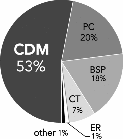
Results. Cerro del Medio obsidian dominates the aggregate obsidian assemblage from the ancestral Jemez pueblos sampled by WARP. Jemez flintknappers flaked more artifacts from Cerro del Medio obsidian (n = 1,173) than from all other sources combined (n = 1,049), representing more than half of the total number of analyzed artifacts (Figure 3). When comparing the assemblages from the 31 sites to one another, Cerro del Medio obsidian emerges as uniquely ubiquitous, as it is the only source quarry represented in the chipped stone assemblage of each and every site sampled by WARP. At the individual site level, Cerro del Medio was the most abundant source at 21 of the 31 sampled sites (see Table 2).
Percentage of total WARP assemblage obsidian from Jemez Mountains sources (31 sites; n = 2,222). CDM = Cerro del Medio/Valles Rhyolite; BSP = Bear Springs Peak/Canovas Canyon Rhyolite; PC = Paliza Canyon/Bearhead Rhyolite; CT = Cerro Toledo Rhyolite; ER = El Rechuelos Rhyolite.
Patterns of obsidian acquisition varied through time at ancestral Jemez pueblos. Breaking down the WARP sample chronologically, distinct temporal trends emerge in these data. Cerro del Medio obsidian acquisition increased dramatically between AD 1300 and 1700 (Figure 4). At pueblos settled during the first half of this period, Cerro del Medio obsidian accounts for less than half of the total obsidian assemblage (39.1%, n = 482 of 1,234). But the middens at sites occupied between AD 1500 and 1700 (as established by the presence of Rio Grande Glaze D, E, and F ceramics) are bursting with obsidian from Cerro del Medio, comprising 69.9% of the assemblage (n = 691 of 988). While some of this increase relates to the proximity of the early villages to the Paliza Canyon and Bear Springs Peak sources, this intensification in the use of Cerro del Medio obsidian indexes a surge in the use of the Valles Caldera landscape by Jemez people in the sixteenth century.
Comparison of obsidian provenience in assemblages at ancestral Jemez pueblos occupied early (AD 1300–1500) and late (AD 1500–1700) in the Jemez archaeological sequence. CDM = Cerro del Medio/Valles Rhyolite; BSP = Bear Springs Peak/Canovas Canyon Rhyolite; PC = Paliza Canyon/Bearhead Rhyolite; CT = Cerro Toledo Rhyolite; ER = El Rechuelos Rhyolite.

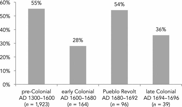
The 1598 colonization of New Mexico by Europeans transformed the Jemez relationship with the Valles Caldera, however (Figure 5). Following the imposition of Spanish rule, the amount of Cerro del Medio obsidian at Jemez sites dropped from 55.1% at sites occupied prior to colonization (n = 1,061 of 1,923) to 28% at sites constructed between AD 1600 and 1680 (n = 46 of 164). This suggests a significant decrease in Jemez interactions with Wâavēmâ during this period. When the Spaniards were expelled from New Mexico in the wake of the Pueblo Revolt of 1680, use of the Cerro del Medio source returned to precolonial levels (54.2%, n = 52 of 96). And when Spanish colonial rule resumed in the mid-1690s, Cerro del Medio obsidian use plummeted once again, dropping to 36% (n = 14 of 39). These data establish a clear pattern: under two separate periods of Spanish colonial rule (1598–1680 and 1694–1696), the Jemez drastically reduced their use of Cerro del Medio obsidian. By comparison, during times when the Pueblos lived unfettered by the shackles of colonialism (pre-1598 and 1680–1692), quantities of Cerro del Medio obsidian at Jemez sites spiked, indicating increased interactions with the Valles Caldera.
Percentage of Cerro del Medio obsidian (Valles Rhyolite) in the assemblages of ancestral Jemez pueblos through time.
Interpretation
The abundance of Cerro del Medio obsidian at ancestral Jemez pueblos attests to the extensive ties that existed between the residents of these villages and Wâavēmâ. The presence and quantity of Cerro del Medio obsidian indicates that ancestral Jemez people made frequent trips into the Valles Caldera landscape between AD 1300 and 1700, procuring obsidian along the way. Jemez interactions with Wâavēmâ increased in intensity during this time, peaking in the sixteenth century. This upward trend of Cerro del Medio obsidian exploitation suggests that ancestral Jemez familiarity with this landscape increased throughout the three centuries preceding Spanish colonization.
Why did ancestral Jemez flintknappers prefer Cerro del Medio obsidian over the volcanic glass available from other nearby sources? Was this material simply superior to that from the other quarries? Recent archaeological studies suggest not, noting that obsidian from the Cerro del Medio, El Rechuelos, and Cerro Toledo sources all produce excellent chipped stone tools. Shackley, for example, writes that the Jemez Mountains obsidian sources “are as good a media for tool production as anywhere” (Shackley Reference Shackley2005:64). Differences in the representation of these sources at Ancestral Pueblo villages of the northern Rio Grande are more likely to reflect differences in acquisition than in raw material preferences (Arakawa et al. Reference Arakawa, Ortman, Shackley and Duff2011:785). Spatial proximity to source locations did play a role in source selection, with pueblos located closer to the Bear Springs Peak and Paliza Canyon sources often exhibiting higher proportions of artifacts from those sources (e.g., LA 189, 386, 5918, 5920, and 24788; see Table 2). Nonetheless, there are numerous exceptions to this rule. Most conspicuously, residents of LA 303 (Seshukwa) and LA 478 (Wabakwa)—both of which are located closest to the Paliza Canyon source—obtained the majority of their obsidian from the more distant Cerro del Medio source (representing 72% and 63% of their assemblages, respectively).
So why would ancestral Jemez peoples choose to journey farther to obtain obsidian from Cerro del Medio rather than simply employing the least-cost path to use a closer source, particularly given the high-quality material available nearby? One possibility is that obsidian obtained from within Wâavēmâ retained special meanings for the Jemez. Another possibility is that ancestral Jemez people collected this obsidian opportunistically while tending to other tasks in the Valles Caldera (such as retreats, pilgrimages, and ritual hunting expeditions). In either scenario, the presence of Cerro del Medio obsidian is an indexical sign of the importance the Valles Caldera landscape held for the residents of these sites. While the symbolic meanings of this landscape may have included associations of life, fertility, sustenance, and power, the archaeological record does not directly address these associations in the distant past. However, archaeology can examine the indexical meanings embedded in obsidian artifacts, revealing the temporal changes in obsidian acquisition that occurred at Jemez villages through time.
The most significant temporal shifts in Jemez obsidian procurement occurred in relation to Spanish colonialism, when use of the Cerro del Medio quarry declined significantly (see Figure 5). Exactly why and how colonial rule constrained ancestral Jemez uses of the Valles Caldera (twice) remains hazy. The introduction of metal seems not to have effected this shift, as obsidian from sources other than Cerro del Medio abound at seventeenth-century Jemez sites. The prevalence of obsidian from Cerro Toledo, Bear Springs Peak, and Paliza Canyon shows no significant decline in the use of obsidian overall during the first century of colonial occupation, when metal tools became more readily available. Neither did this pattern result from direct, heavy-handed Spanish control over Pueblo mobility. The residents of the villages in question lived as far as 6 km away from the nearest colonial settlement, so their movements back and forth to the Valles Caldera would have been relatively unencumbered by colonial policies and agents. More likely, the drop in use of Cerro del Medio obsidian resulted from two factors: increased labor demands on Jemez “subjects” during the colonial regime and an increase in raiding and violence during the colonial era.
Spanish colonial enterprises in New Mexico—both secular and ecclesiastical—required Pueblo labor for their very existence. Beginning with Don Juan de Oñate's colonization in 1598, Spanish demands for corn, textiles, and hides transformed Pueblo life and, subsequently, their patterns of movement. Spielmann and her colleagues’ work at the Salinas Pueblos reveals the changes that took place in Pueblo agricultural practices, gathering, hunting, and butchering activities after missions were established in the seventeenth century (Spielmann et al. Reference Spielmann, Clark, Hawkey, Rainey and Fish2009). Spanish expropriation of Pueblo labor shaped even the Salinas people's bodies, with bioarchaeological studies indicating an increase in musculoskeletal stress markers due to intensification of heavy and repetitive tasks during this period. The impact of tribute and labor demands on Pueblo people likely played a role in disrupting Jemez movements back and forth to Wâavēmâ as well, ultimately resulting in less Cerro del Medio obsidian deposited in the middens at ancestral Jemez sites. The new requirements of encomienda and repartimiento for mantas, maize, and labor meant that Jemez people no longer had the ability to move through the landscape in the same ways they had done before the Spaniards arrived.
Furthermore, Spanish colonialism disrupted traditional trade relations between Pueblo peoples and the surrounding nomadic tribes (the ancestors of today's Navajo, Apache, and Ute Nations). Prior to European colonization, the Jemez appear to have maintained relatively stable trade relations with their nomadic neighbors (Brugge Reference Brugge, Wiseman, O'Laughlin and Snow2002). Of the Pueblo ceramic types typically found at sixteenth- and seventeenth-century Navajo sites, for example, Jemez pottery is the most common (Reed and Reed Reference Reed, Reed, Reed and Reed1992:100–101). But the introduction of Old World domesticates such as cattle and sheep disrupted this exchange by devaluing Navajo, Apache, and Ute trade items, particularly protein-rich foodstuffs such as bison meat (Spielmann Reference Spielmann1991). The Spaniards’ seizure of Pueblo agricultural surpluses through extortionate taxation further served to undermine this trade network, as the Pueblos no longer possessed surplus maize to exchange with their former trading partners. In order to obtain these much-needed foodstuffs, nomadic groups took to raiding Pueblo villages with increasing intensity throughout the seventeenth century. As early as 1607, raids had become so problematic that one Friar reported that “the peaceful natives of New Mexico are frequently harassed by attacks of the Apache Indians, who destroy and burn their pueblos, waylay and kill their people by treachery . . . and cause other damages” (Hammond and Rey Reference Hammond and Rey1953: 2:1059). Attacks on Jemez villages in 1639, the mid-1650s, and again in 1659 killed more than 20 residents, with at least 34 captives spirited away by Navajo aggressors. The adoption of equestrian lifestyles by the Navajo, Apache, and Ute dramatically improved the efficiency of their raids throughout this period, and the Pueblos suffered a corresponding escalation in raiding and violence during the early colonial era (Liebmann Reference Liebmann2012:41–44; Mitchell Reference Mitchell2015: 79–81).
In the Jemez region, this escalation in raiding and violence likely transformed the Valles Caldera into a dangerous place. To access the Cerro del Medio obsidian quarry, ancestral Jemez travelers would have crossed a series of open meadows, some as wide as 5 km. Any party who undertook this journey would have been proverbial sitting ducks, leaving themselves particularly vulnerable to ambush with no cover. Historical records attest to the peril of this crossing, reporting clashes in the Valles Caldera between Jemez and Navajo warriors throughout the eighteenth century (McNitt Reference McNitt1972:185, 256–257). Jemez oral traditions recount additional raids not mentioned in documentary records (Sando Reference Sando1982:11–12). These accounts suggest that the increase in violence and raiding during the seventeenth century likely turned the Valles Caldera into a treacherous landscape. If Wâavēmâ became associated with bloodshed due to clashes between the Jemez and surrounding nomadic bands during the Spanish colonial era, as seems likely, it is understandable that the quantity of Cerro del Medio obsidian at ancestral Jemez sites ebbed accordingly—and that the symbolic meanings associated with this landscape would likely have changed as well.
Use of Cerro del Medio obsidian surged again following the famous Pueblo Revolt of 1680, when the Jemez evicted their Spanish colonizers. With the Spaniards gone, the pressures that had exacerbated poor relations with their nomadic neighbors subsided. Apaches and Navajos allied with the Pueblos, taking up arms in the 1680 uprising. Relations between these groups remained strong throughout the Spanish interregnum, and when the Spaniards returned to New Mexico a dozen years later they found “Apaches” living side-by-side with the Jemez (Liebmann Reference Liebmann2012:183–185). This rapprochement among the indigenous peoples of New Mexico may have encouraged increased use of the Valles Caldera once again, as borne out in the lithic assemblages of LA 96 (Patokwa) and LA 136 (Boletsakwa), both occupied from 1680 to 1692. Yet when Spanish colonists returned to New Mexico in 1692, Jemez access to Wâavēmâ diminished once more. The same factors that caused the decrease in Jemez use of Cerro del Medio obsidian prior to the 1680 Revolt came into play yet again, with hostilities between the Pueblos and their Navajo and Apache neighbors waxing in the years after the Spanish reconquest of New Mexico.
Even with the decreased exploitation of Cerro del Medio obsidian that occurred during discrete periods of Spanish colonization in the seventeenth century, the Jemez people consistently and continuously used the Valles Caldera from prehispanic times through the twenty-first century. The prevalence of Cerro del Medio obsidian at ancestral Jemez sites investigated by WARP shows that the Jemez maintained a lasting presence in the Valles Caldera between AD 1300 and 1700, while historical documents attest to their continued use of this landscape between the eighteenth century and today (Anschuetz Reference Anschuetz, Anscheutz and Merlan2007; Weslowski Reference Weslowski, Baker and Winter1981). Despite restrictions imposed on the Jemez and on the Valles Caldera landscape by three different colonial regimes (the governments of Spain, Mexico, and the United States), the links between the Jemez people and Wâavēmâ remain unbroken through the course of at least seven centuries. The Jemez have never stopped visiting the Valles Caldera, a landscape that has remained as vital in maintaining their cultural identity through the centuries as Vatican City has for Roman Catholics, Jerusalem for Jews, and Mecca has for Muslims.
Conclusion
Over the past three decades, LoM approaches and collaborative archaeologies have transformed the way archaeologists study the landscapes of the past (David and Thomas Reference David, Thomas, David and Thomas2008; Fowles Reference Fowles2010; Knapp and Ashmore Reference Knapp, Ashmore, Knapp and Ashmore1999; Silliman and Ferguson Reference Silliman, Ferguson, Ashmore, Lippert and Mills2010). But their fixation on symbolic meaning has led archaeologists to an impasse. By employing direct historical analogies, many of these studies have inadvertently produced timeless, essentialized visions of the past—landscapes of symbolism whose meanings remain constant from time immemorial to the present day. As semiotic studies routinely demonstrate, however, meanings are not static. Meanings shift and transform across time and space. Temporality is thus a critical component of the analysis of archaeological landscapes (Hicks Reference Hicks2016; Ingold Reference Ingold1993). In order to reconstruct landscapes as dynamic as the people who traveled through them, archaeologists need to account for the varieties of meaning that exist as well as temporal variations in those meanings.
The LoS approach seeks to shift archaeological focus from static, ever-present symbolism to an emphasis on the dynamics revealed through indexical meanings. In this way, the LoS approach is not a refutation of previous LoM studies, but an extension of them. LoS studies attend to both the source- and subject-sides of our analogies. They marry symbolic and indexical meanings. They build dynamic bridges between the present and the past, and attempt to unite ethnography and archaeology. By directing our attention to changes in indexical signs, we can begin to discern the processes and conditions that give rise to the symbolic meanings of today.
Ancestral Jemez uses of the Valles Caldera provide a case in point. To the contemporary residents of Jemez Pueblo, the Valles Caldera is a living landscape that symbolizes life, fertility, sustenance, and power. Rather than simply projecting these associations onto the past, we can examine indexical markers of Jemez interactions with Wâavēmâ between the fourteenth and eighteenth centuries to track the ways in which these meanings were forged. Obsidian from the Cerro del Medio quarry indicates that Jemez interactions with this landscape intensified between AD 1300 and 1600. Following the Spanish colonization of the northern Rio Grande, these interactions diminished, likely because of increased labor demands and violence during this period. The seventeenth-century transformation of the Valles Caldera added indexical meanings to Cerro del Medio obsidian as well, pointing to the difficulties of its acquisition as a result of Spanish rule. During periods of colonial occupation, the Valles Caldera became dangerous as well as sacred. Yet even despite the limitations in access that arose during periods of colonial rule, the archaeological record verifies that the Jemez maintained a continuous relationship with the Valles Caldera landscape from at least AD 1300 to the present day.
Ultimately, the LoS approach challenges the false dichotomies that have plagued collaborative archaeologies of landscape in recent years. Archaeologists do not need to choose between objective science on the one hand, or the investigation of meaning on the other. Nor can we maintain a strict separation between the meanings of the present and the past, as the latter constitutes the former. At its core, the LoS approach embraces anthropological attempts to see a dynamic world through different eyes. The insights provided by present-day descendant and stakeholder communities, combined with those offered by the indexical properties of the archaeological record, provide new interpretations and ultimately more dynamic understandings of the human past.
Acknowledgments
T'ebáno:pa to the Pueblo of Jemez for their support and partnership in this research. Thanks to Steve Shackley and Bruce Kaiser for their help and advice with the XRF analysis, and to Adam Stack for drafting Figure 1. Thanks as well to Mike Bremmer of the USFS, Ana Steffen of the VCNP, and the American Society for Prehistoric Research for facilitating this research. I am particularly grateful to Robert Kelly, Rowan Flad, Jason Ur, the students of Anthro 1150: Ancient Landscapes (Spring 2017) at Harvard University, and three anonymous reviewers for their insightful comments on previous iterations of this paper. WARP research was conducted under permit SFE212802 by the USFS, Santa Fe National Forest, Jemez Ranger District.
Data Availability Statement
The full XRF obsidian data set, including trace element analysis reported in ppm for all 2,222 individual artifacts, is archived at https://core.tdar.org/dataset/426269/Waavema-archaeological-research-project-obsidian-xrf-database.


 Open access

