


Introduction
Like Arctic permafrost (Hollesen et al. Reference Hollesen2018), high-elevation ice patches and glaciers are melting due to the warming global climate. Glacial archaeology has developed to rescue artefacts exposed by this process (Dixon et al. Reference Dixon, Callanan, Hafner and Hare2014), with archaeologists studying melting ice sites in North America, the Alps and Scandinavia (e.g. Hare et al. Reference Hare, Thomas, Topper and Gotthardt2012; Hafner Reference Hafner and Hafner2015; Pilø et al. Reference Pilø, Finstad, Bronk Ramsey, Martinsen, Nesje, Solli, Wangen, Callanan and Barrett2018). This research is revealing past trends in high-elevation hunting, transhumance and travel associated with social, economic and ecological mechanisms. Such work is uniquely important because organic materials are preserved under these situations and because sediment movement (erosion of slopes and deep accumulation deposits in valleys) obliterates or obscures much mountain archaeology (Gilck & Poschlod Reference Gilck and Poschlod2019). Central Norway has yielded the largest number of recorded finds from mountain ice (e.g. Callanan Reference Callanan2012, Reference Callanan2013; Pilø et al. Reference Pilø, Finstad, Bronk Ramsey, Martinsen, Nesje, Solli, Wangen, Callanan and Barrett2018). In Oppland County, the Glacier Archaeology Program has systematically surveyed 51 ice patches and small glaciers, recovering more than 3000 artefacts, including textiles and tools, and more than 450 associated finds (e.g. reindeer antlers, horse bones and samples of horse dung). All the Oppland ice sites were used for hunting (Pilø et al. Reference Pilø, Finstad, Bronk Ramsey, Martinsen, Nesje, Solli, Wangen, Callanan and Barrett2018; Solli Reference Solli2018), a characteristic that they share with North American sites (Reckin Reference Reckin2013). One of these Norwegian sites, Lendbreen, is distinctive because it also provides evidence for use as a mountain pass. It is the first such ice site discovered in Northern Europe, the archaeology of glaciated mountain passes being otherwise better understood from research in the Alps (Hafner Reference Hafner and Hafner2015; Curdy Reference Curdy, Providoli, Curdy and Elisig2016).
The Lendbreen ice patch came to prominence in 2011, following the discovery of a third- or fourth-century AD wool tunic (Vedeler & Bender Jørgensen Reference Vedeler and Jørgensen2013). Subsequent survey of the area surrounding this garment has revealed approximately 800 artefacts, some 150 bones and antlers, more than 100 cairns and the foundations of a stone-built shelter (Pilø Reference Pilø2018; see below). It is now clear that Lendbreen was a focal point for regional transhumance and probably also long-range travel starting during the Roman Iron Age (AD 1–400) through until the end of the Middle Ages (AD 1050–1537). The site's exceptionally rich archaeological material illustrates a long-lived transhumance system in seasonally changing mountain terrain, and provides a model pertinent to the study of mountain passes globally. Such passes played key roles in past mobility, facilitating and channelling transhumance, intra-regional travel and long-distance journeys (Bergman et al. Reference Bergman, Östlund, Zackrisson and Liedgren2007; Walsh et al. Reference Walsh, Court-Picon, Beaulieu, Guiter, Mocci, Richer, Sinet, Talon and Tzortzis2014; Hafner Reference Hafner and Hafner2015; Curdy Reference Curdy, Providoli, Curdy and Elisig2016).
Glacial archaeology at Lendbreen
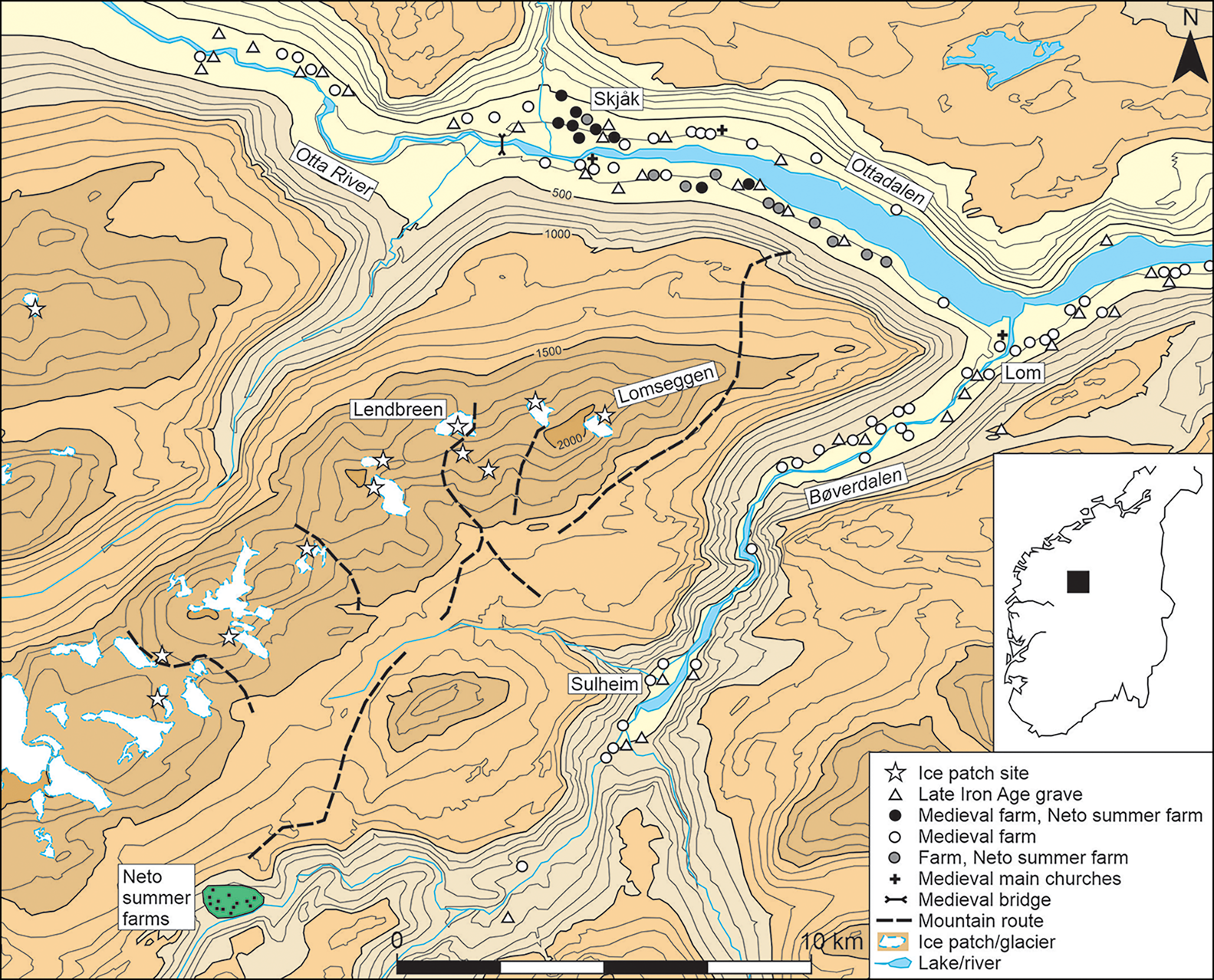
Lendbreen is a retreating ice patch on a steep north-facing slope of the Lomseggen ridge, the patch itself starting at 1690m asl and rising to approximately 1920m asl (Figure 1). The pass directly above the ice patch reaches 1973m asl. In a pattern typical of the periodic expansion and contraction of ice patches in response to climatic change (Ødegard et al. Reference Ødegård, Nesje, Isaksen, Andreassen, Eiken, Schwikowski and Uglietti2017), melting ice has revealed lichen-free areas of scree and bedrock. It is here that most of the artefacts have been found, lying on bare ground. The finds have thus undergone vertical displacement and have sometimes also been moved laterally by meltwater and strong winds. Although ice patches are predominantly stationary (unlike glaciers), some ice deformation (displacement from the plane of accumulation) also occurs (Ødegard et al. Reference Ødegård, Nesje, Isaksen, Andreassen, Eiken, Schwikowski and Uglietti2017). The positions of the objects (especially those of light organic materials), as found during systematic survey and recorded by GPS, therefore do not reflect the precise location of their original deposition (Pilø Reference Pilø2018). A Bronze Age ski, for example, was found in four pieces separated by as much as 250m (Finstad et al. Reference Finstad, Martinsen, Hole and Pilø2018). While these post-depositional processes blur the resolution of the finds distribution at Lendbreen, they do not obliterate what remains a clear trail of features and finds that delineate a short crossing place over the mountain ridge.
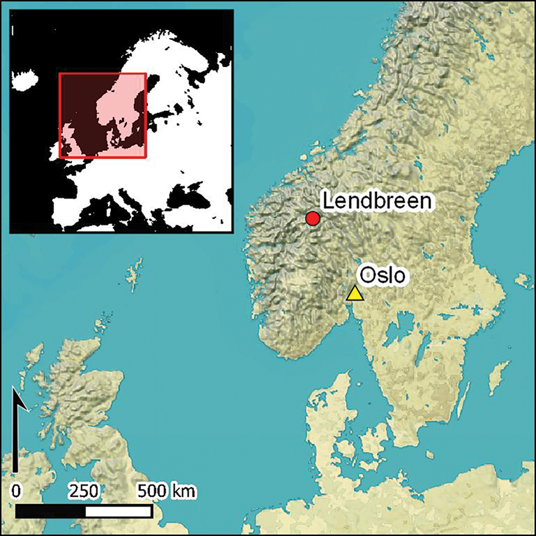
Lendbreen within its regional and Norwegian setting (map: L. Pilø).
Crossing Lomseggen
Before the mid nineteenth century, the easiest way to travel from the upper part of the Ottadalen Valley to the rich summer pastures in the Neto area (Figure 1) was by crossing the Lomseggen ridge—by one pass or another (Figure 1). The passage over Lomseggen was shorter than following the river valleys, and the terrain was easily traversed in many areas above the treeline. Using mountain routes facilitated transport and communication as part of both inter-regional travel and seasonal transhumance between permanent settlements along the Otta River and summer farms at Neto, where livestock was seasonally grazed at higher elevations. Several such routes over Lomseggen are known from local oral history (Kummen Reference Kummen1983) and, although Lendbreen is not known among these routes, the distribution of archaeological features and artefacts across the site demonstrates that it must once have served a similar function. Lendbreen is unique in that it is the first known route up to a pass that crosses an ice patch, and hence provides exceptional preservation conditions for artefacts lost by past travellers.
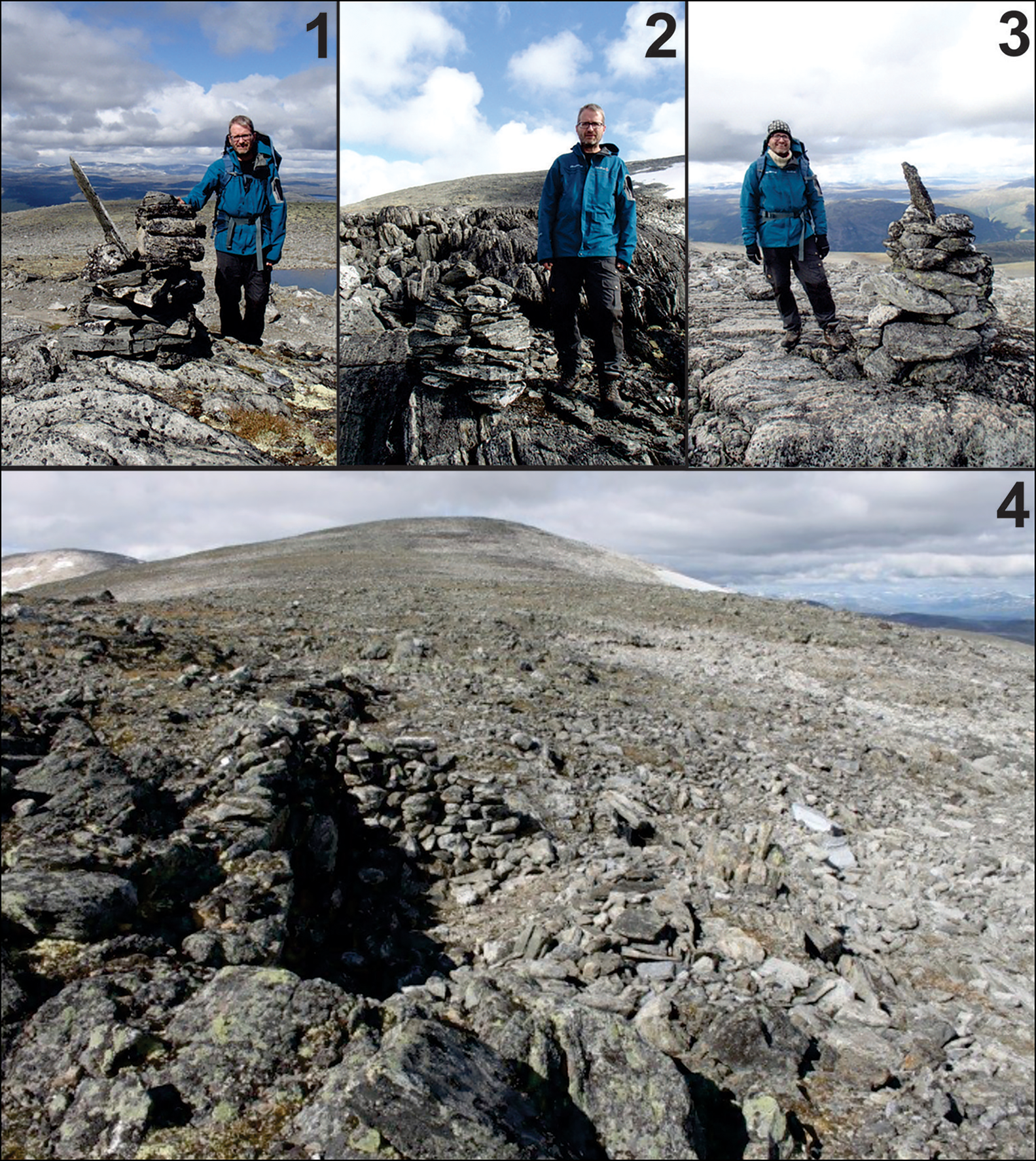
At Lendbreen, a sequence of cairns marks the way up the northern, partly ice-covered slope, over the summit ridge and down its southern face towards the Bøverdalen Valley (Figure 2). Here, the route probably split, with one path leading to the large permanent farm of Sulheim and another heading south-west to Neto. The cairns at Lendbreen cannot yet be dated directly, as lichenometry remains to be applied (cf. Bergman et al. Reference Bergman, Östlund, Zackrisson and Liedgren2007). The chronology of the route can instead be inferred by radiocarbon dating the associated artefacts that have melted out of the ice along the route. The ruin of an undated stone-built shelter is situated near the top of the ice patch (Figure 3). Among five mountain passes on Lomseggen known from historical oral accounts and/or archaeology, only Lendbreen has such a shelter and a large number of cairns. It was clearly a route of special significance.
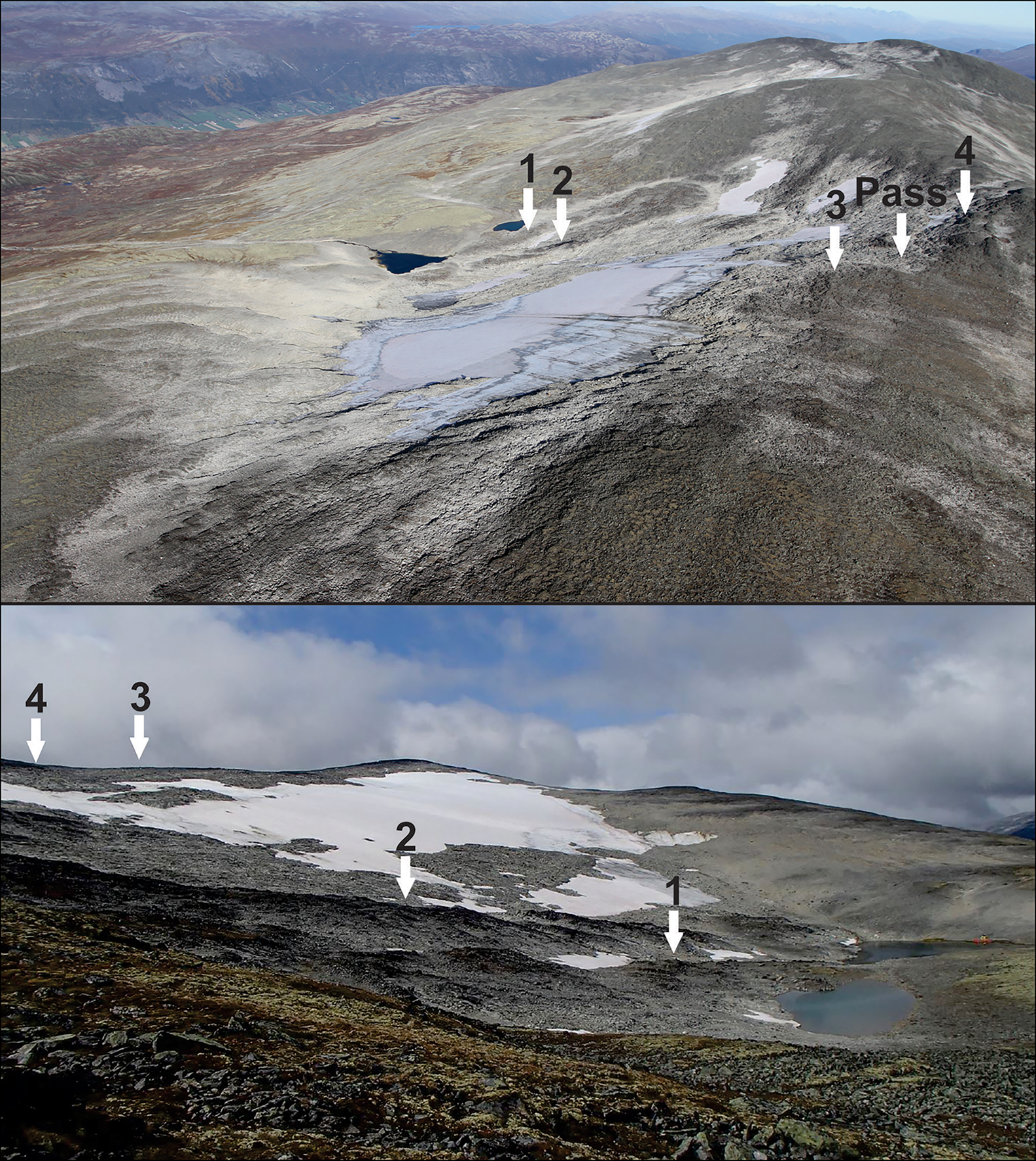
Above) aerial view of Lendbreen from the south-west; light-grey areas (without lichen) have seen recent ice-melt (photograph: L. Pilø); below) Lendbreen from the north-east; arrows 1–3 indicate the locations of cairns visible on approach from Ottadalen; arrow 4 indicates the location of a stone-built shelter (photograph: J.H. Barrett).
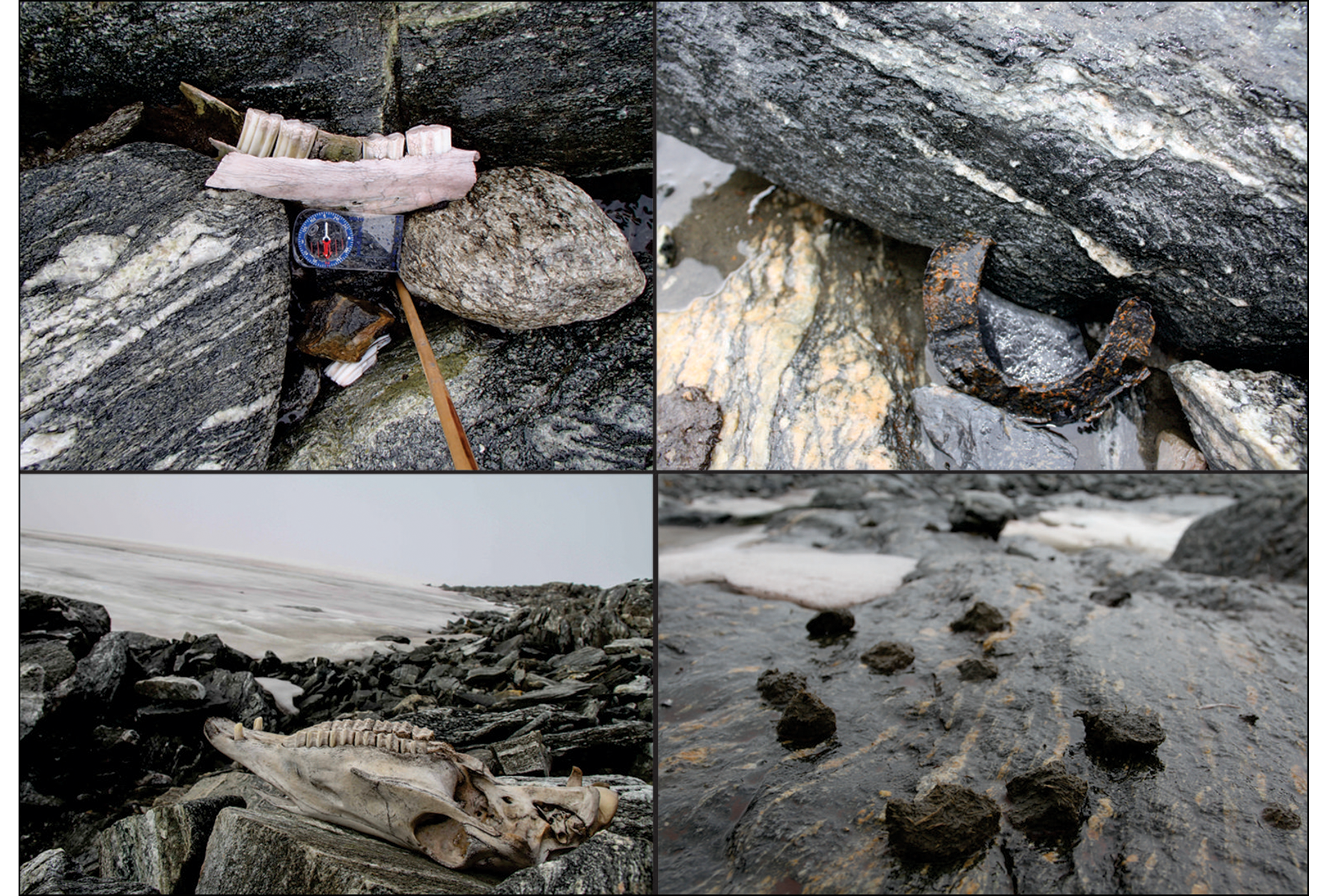
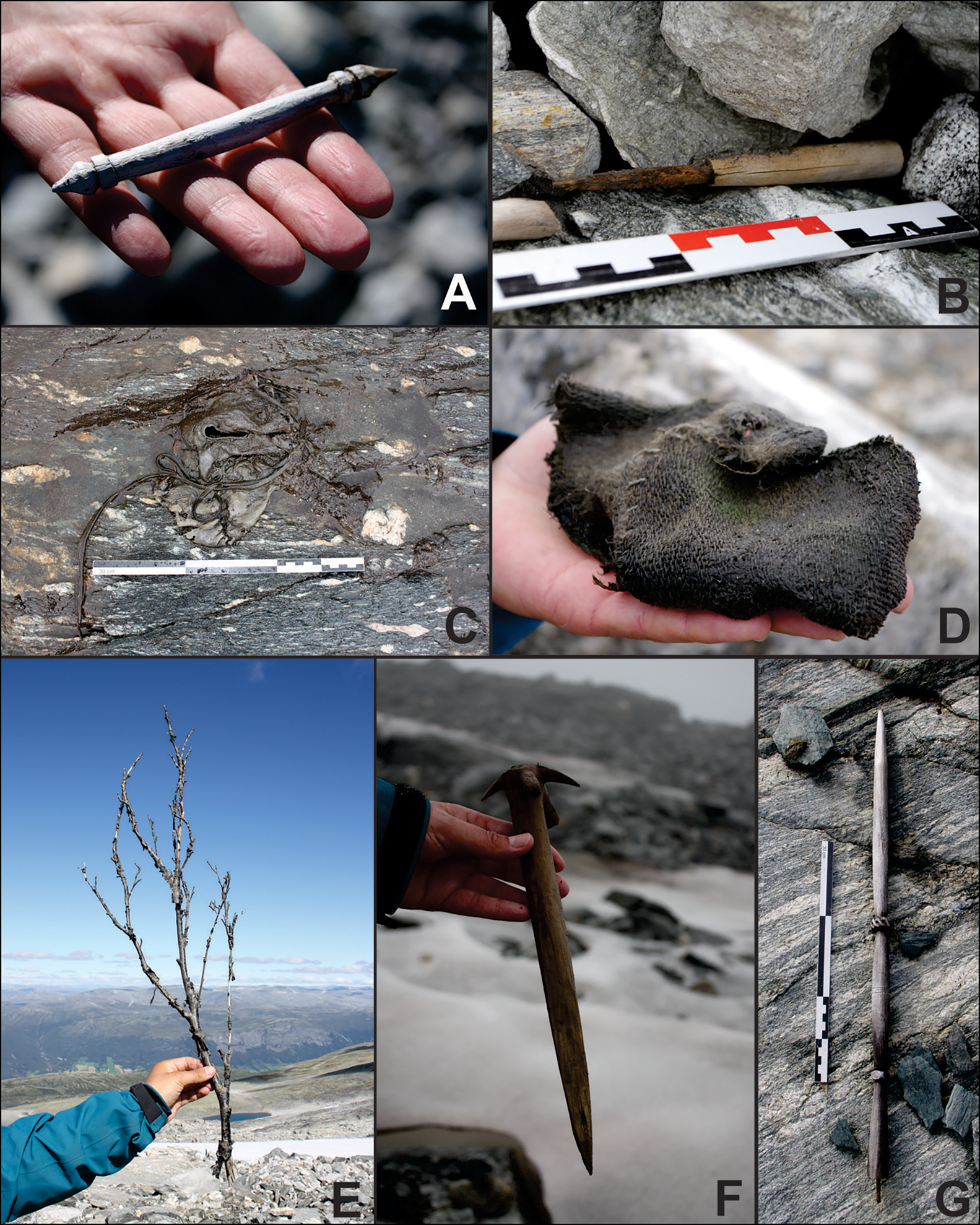
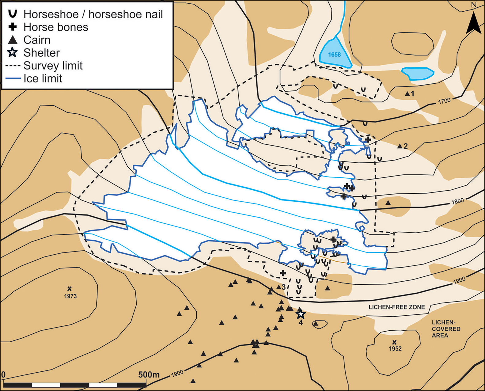
The finds assemblage associated with the mountain pass is diverse, containing transport-related artefacts and ecofacts, such as the remains of sleds, walking sticks, horseshoes, horse bones and horse dung (Figure 4). It also includes everyday objects, particularly clothing and textile items, such as a tunic, a woven mitten, several shoes made from hide and more than 50 textile rags (Figure 5). The spatial distribution of these objects is clustered, with much of the patterning related to a combination of the route most travelled and post-depositional processes. In addition to the cairns, the main path is indicated by a distribution of horse-related artefacts and ecofacts (Figure 6). Given their mass, the iron horseshoes and nails are less likely to have been displaced than the lighter organic objects, and should therefore provide a reliable indication of the route. Other objects were more scattered, perhaps reflecting hunting activity or individuals taking different paths up the ridge. Alternatively, scattered finds may represent the post-depositional spreading of lighter objects.
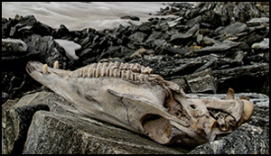
Horse-related finds from Lendbreen: top left) mandible; top right) horseshoe; bottom left) horse skull; bottom right) horse dung (photographs: J.H. Barrett & Glacier Archaeology Program).
Objects related to clothing and daily life: A) goat or lamb bit?; B) knife; C) shoe; D) mitten; E) leaf-fodder; F) whisk and/or peg; G) distaff? (photographs: Glacier Archaeology Program & J. Wildhagen).
Distribution of horse finds, cairns and the shelter at Lendbreen (map: L. Pilø).
In some places, the route indicated by cairns and artefacts crossed very rough terrain that, in the absence of thick snow cover, would have been challenging or impossible to cross with packhorses. If covered by firm snow, however, the route would have been easy to use. Historically, local people used snow-covered glaciers for travel, especially in spring and early summer (Møller Reference Møller1976).
Chronology
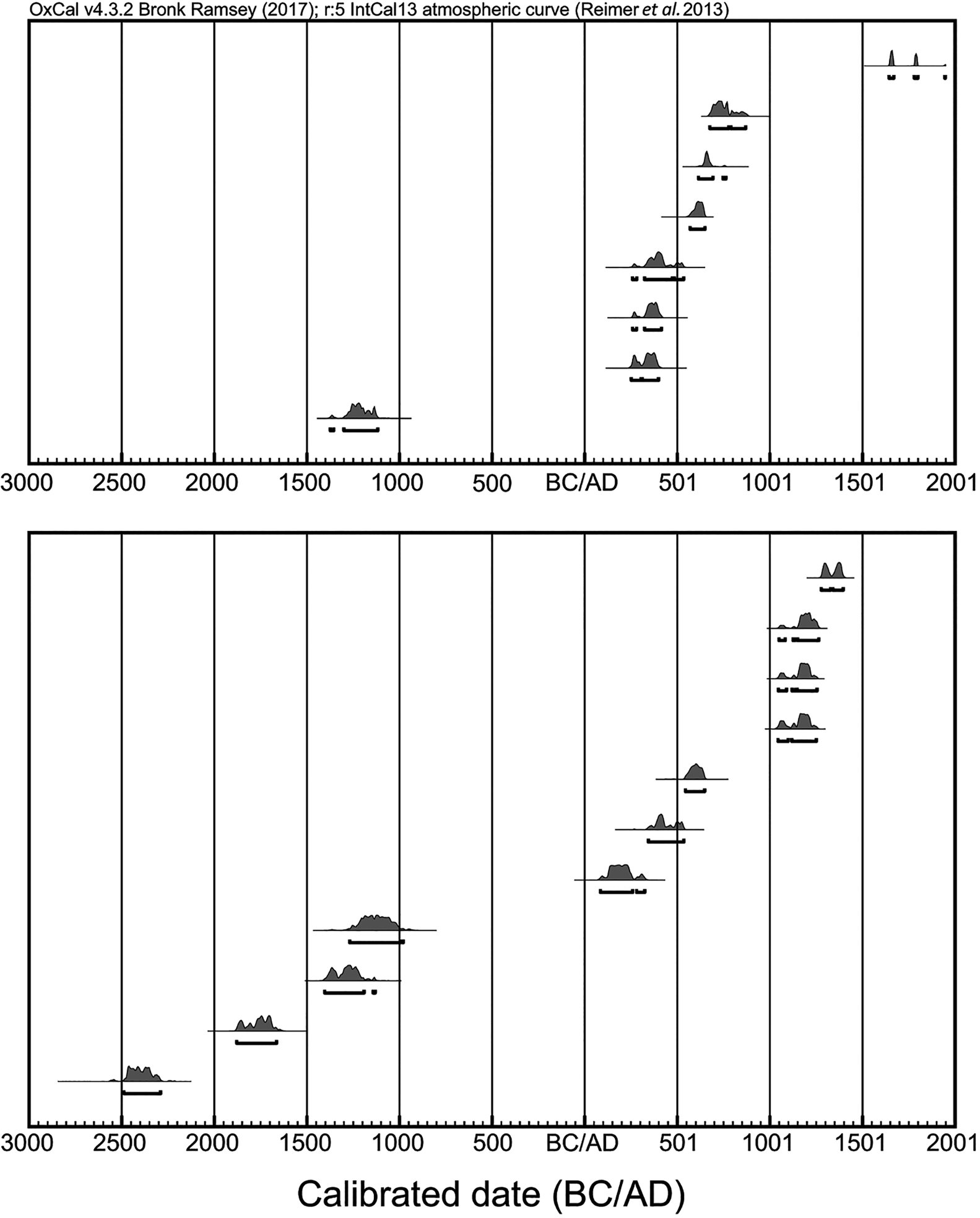
Sixty finds from the Lendbreen assemblage have been radiocarbon dated (Rosvold Reference Rosvold2017; Pilø et al. Reference Pilø, Finstad, Bronk Ramsey, Martinsen, Nesje, Solli, Wangen, Callanan and Barrett2018). The dated material can be divided into four groups. First, six dates refer to objects made from the wood of long-lived trees (pine and ash), and must be treated as imprecise given potential ‘old-wood’ effects. Although these six dates are excluded from the counts and radiocarbon plots that follow, the date of the Bronze Age ski (one of the earliest artefacts from the site, regardless of any old-wood effect) is worthy of attention. Second, eight dates belong to objects related to hunting: five on arrows, one on a ‘scaring stick’ (a stick with a flag-like top, used to guide the movement of deer) and two on cut reindeer antlers. Third, 35 dates come from miscellaneous other objects probably relating to mountain travel. Fourth, 11 samples of natural palaeozoological material have also been dated (Rosvold Reference Rosvold2017).
The results of the radiocarbon dating are mostly published in Pilø et al. (Reference Pilø, Finstad, Bronk Ramsey, Martinsen, Nesje, Solli, Wangen, Callanan and Barrett2018), who discuss reindeer hunting on ice patches, and all available dates are provided here in the online supplementary material (OSM). The few (and chronologically diverse) dates for finds related to hunting and natural palaeozoological material are individually plotted in Figure 7 using probability distributions. Figure 8 shows the more abundant (and chronologically constrained) finds—probably associated with the mountain pass—plotted using the newly available kernel density estimation (KDE) function in OxCal (Bronk Ramsey Reference Bronk Ramsey2017; Pilø et al. Reference Pilø, Finstad, Bronk Ramsey, Martinsen, Nesje, Solli, Wangen, Callanan and Barrett2018). This approach combines radiocarbon dates without the noise (i.e. the spurious peaks and troughs) characteristic of traditional summed probability distributions.
Calibrated radiocarbon dates (Reimer et al. Reference Reimer2013; Bronk Ramsey Reference Bronk Ramsey2017): above) hunting-related finds from Lendbreen (objects of pine and ash excluded); below) palaeozoological samples of uncut reindeer antler, reindeer bone and a bear skull.
Kernel density model (KDE) distribution of radiocarbon dates on 35 finds from Lendbreen that probably reflect mountain travel and transport (objects of pine and ash excluded). The plot shows (in light grey) the sum of the calibrated date distribution and (in dark grey) an estimate of the underlying distribution of events using a KDE (Bronk Ramsey Reference Bronk Ramsey2017). The blue band provides a ±1σ estimate of the KDE model uncertainty.
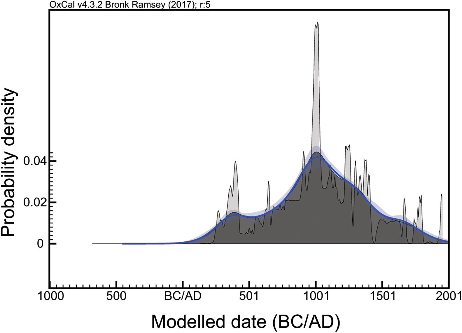
Lendbreen saw some activity in the Bronze Age (1750–500 BC), indicated by the ski and an arrow from this period. Following a hiatus, hunting activity appears to have resumed c. AD 300, at the time transport through the pass started. Although the number of relevant finds is small, hunting may have decreased in the tenth century AD; exceptions include three crossbow bolts, one clearly post-medieval. The other, more abundant finds suggest that transport and travel peaked c. AD 1000, with few dates later than the fifteenth to sixteenth centuries.
Could this chronological patterning be taphonomic, a result of alternating warm (melting/destructive) and cold (freezing/preserving) episodes? Indeed, the glacier curves for the region show multiple expansions and contractions of high-elevation ice over the chronology of Lendbreen's use for hunting and as a mountain pass (Matthews & Dresser Reference Matthews and Dresser2008; Pilø et al. Reference Pilø, Finstad, Bronk Ramsey, Martinsen, Nesje, Solli, Wangen, Callanan and Barrett2018). Could material belonging to an early use of the route have been lost due to melting prior to AD 300? This question can be addressed by examining the age of the earliest finds in the pass area. These include a bear skull (2489–2291 cal BC), a piece of unworked reindeer antler (1880–1665 cal BC), an arrow (1374–1118 cal BC) and part of a ski (791–540 cal BC) (note that all radiocarbon dates are calibrated using OxCal version 4.3.2 (Bronk Ramsey (Reference Bronk Ramsey2017) with the IntCal13 atmospheric curve of Reimer et al. (Reference Reimer2013), and are given at 95.4 per cent probability). These early organic finds would probably have been lost if there had been a lengthy period with no ice before AD 300. Moreover, the dates of the organic palaeozoological and archaeological materials from Lendbreen do not match, as would be expected if the survival over time of materials was determined by past cycles of ice advance and retreat (cf. Figures 7–8). Thus, within the limits of archaeology, the radiocarbon data probably are a reasonable chronological representation of human use of the site.
Lendbreen as a mountain pass
Post-medieval sources (Grjotheim Reference Grjotheim1978) indicate that permanent settlements along the Otta River included summer farms at Neto (Figure 1). The existence of such settlements can be extrapolated back to at least the Viking Age (AD 800–1050) and the Merovingian period (AD 550–800) based on associated graves (Figure 1 & Table S2). There was a clear need to move livestock from settlements north of Lomseggen to Neto (probably in June) and back again (probably in September). Products also needed to be transported home from Neto, some in summer (e.g. butter) and some perhaps during the autumn or winter, as conditions allowed (e.g. stored fodder) (cf. Timberlid Reference Timberlid, Indrelid, Hjelle and Stene2015).
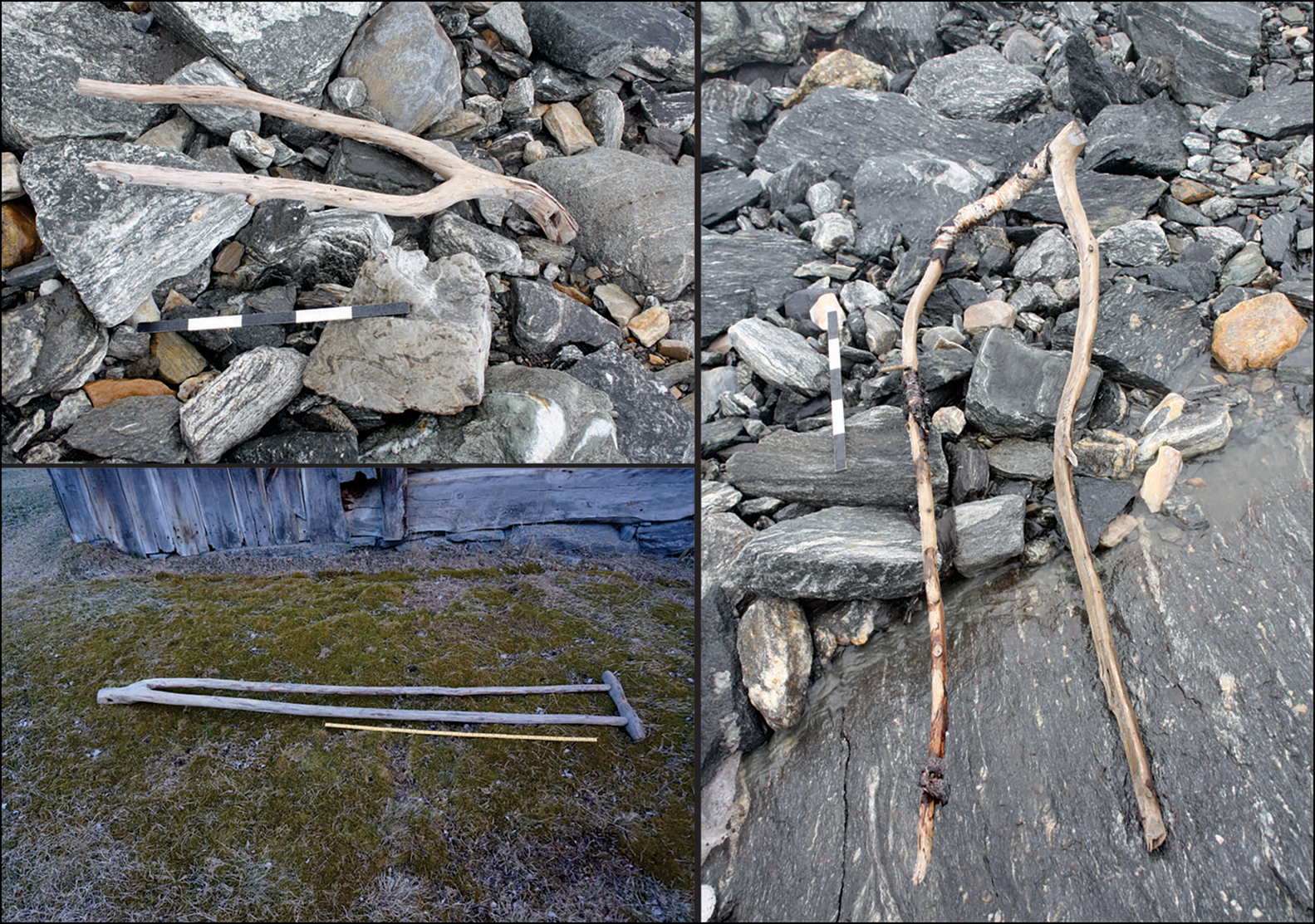
Several artefacts found at Lendbreen were associated with the transport of fodder. Two wooden objects, for example, closely resemble an implement known as a tong (Figure 9), which was used in the recent past for retaining fodder stacked on a wagon or sled (Olsen Reference Olsen2001). One of these implements has been radiocarbon dated to cal AD 264–533, suggesting that the Lendbreen chronology is consistent with high-elevation summer farming as early as the Roman Iron Age. Horses may have needed feed while in transit, but a key role of summer farms in Norwegian transhumance pastoralism was fodder production for winter. Fodder was transported (often over snow later in the year) for cattle wintered in the byres of home farms at lower elevations (Timberlid Reference Timberlid, Indrelid, Hjelle and Stene2015). The 66 twigs found at Lendbreen may represent fragments of ‘leaf fodder’ that, traditionally, was stripped from birch stands around both permanent settlements and summer farms (Timberlid Reference Timberlid, Indrelid, Hjelle and Stene2015). A small wooden object is probably a bit for a young animal, such as a kid or lamb, and was used to limit suckling and thus maximise milk production for human consumption (Figure 5). An undated scythe blade completes the picture of regional transhumance pastoralism.
Upper left) an object interpreted as a tong (a clamp for holding fodder on a sled or wagon) dated to the Late Roman Iron Age; right) a similar, undated object, also from the pass area; lower left) a historical example from Uppigard Garmo, pre-dating c. 1950 (photographs: Glacier Archaeology Program & R. Marstein).
Crossing areas of vertical bedrock and large scree poses the greatest challenge when traversing the Lendbreen pass, but this can be avoided by travelling on the ice patch itself, especially when enlarged by snow. We can therefore envision that the pass was chosen for transhumance early in the season, then for bringing back fodder (among other products) when some snow had returned late in the season, and/or in years of reduced ice-melt.
The evidence from the wider region is consistent with the existence of Iron Age (and earlier) high-elevation grazing, leading to the establishment of summer farms by at least the Roman Iron Age. Palynological research on a bog approximately 3km to the west of Neto shows evidence of first-millennium BC pastures, followed by increased anthropogenic influence on the landscape during the Roman Iron Age (Aukrust Reference Aukrust1982). Other summer farming areas within approximately 80km of Neto have yielded archaeological and/or palynological evidence for use as pasture in the first millennium BC, followed by increasing human activity c. AD 200–300 (Gunnarsdóttir & Høeg Reference Gunnarsdóttir and Høeg2000; Høeg Reference Høeg2014; Hjelle et al. Reference Hjelle, Lødøen, Natlandsmyr, Kvamme, Kaland, Austrheim, Hjelle, Sjögren, Stene and Tretvik2015; see also Stene Reference Stene, Indrelid, Hjelle and Stene2015). The use of summer farms then intensified during the Late Iron Age and the Middle Ages, until the Black Death (which first struck Norway in 1348 or 1349), after which there was a hiatus until c. AD 1600.
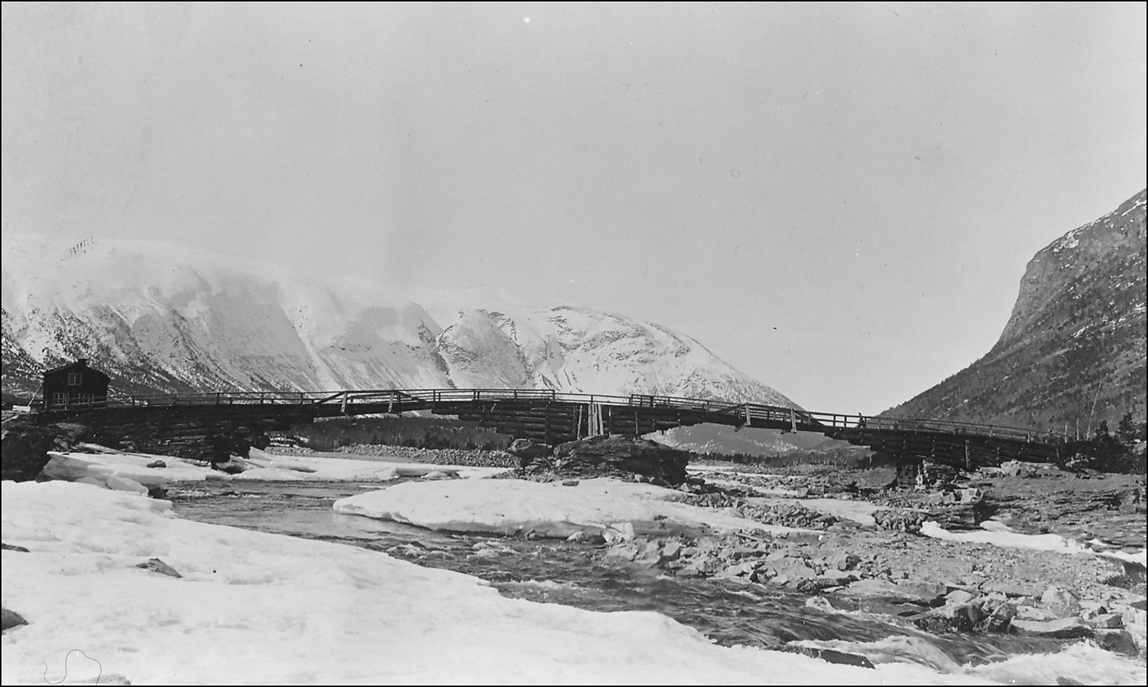
Lendbreen may also have been a preferred crossing among a series of land routes leading to northern, western and eastern Norway. These routes are mainly known from local oral history, which notes, for example, journeys to the fjords of western Norway for barley and dried fish in times of poor harvest (Kleiven Reference Kleiven1973), but also from a charter of c. AD 1400 that records the Vollungsbrua Bridge (Figure 10) over the Otta River in Skjåk (Diplomatarium Norvegicum 1847–2011: V 403). This communication node is important in situating the Lendbreen pass within a system of inter-regional and long-range communication. These routes may have facilitated the transport of high-elevation rural products—ranging from reindeer antlers (for comb making) and pelts to butter produced at summer farms, all of which were Norwegian exports in the Viking Age and/or Middle Ages—to distant, overseas consumers (Nedkvitne Reference Nedkvitne2014: 57–58; Ashby et al. Reference Ashby, Coutu and Sindbæk2015; Indrelid Reference Indrelid, Indrelid, Hjelle and Stene2015; Stene & Wangen Reference Stene, Wangen, Glørstad and Loftsgarden2017; Critch et al. Reference Critch, Harland, Barrett, Kershaw and Williams2018).
The latest timber incarnation of Vollungsbrua (pre-1912), a bridge linking Lendbreen to inter-regional routes (photograph: Gudbrandsdalsmusea, Norddalsarkiva avd. Skjåk).
Discussion
Lendbreen served as a focus for reindeer hunting from the Bronze Age to the Viking Age, with only occasional later use for this purpose. The evidence that Lendbreen also served as a mountain pass, probably for both intra-regional transhumance and long-range travel, increases in quantity from the Roman Iron Age through until the end of the Middle Ages (and occasionally beyond). The site appears to have functioned differently from many other known mountain passes, in that it was used at times when enough snow and ice covered the scree. High passes in the Himalayas and the Alps were often closed during winter or when the advance of glaciers made crossing them very difficult (e.g. Younghusband Reference Younghusband1897; Hafner Reference Hafner and Hafner2015; Providoli Reference Providoli, Providoli, Curdy and Elsig2016). In other ways, however, Lendbreen is more typical. It has cairns delineating the route and a shelter at the top. The presence of dead horses at Lendbreen parallels the skeletons of dead pack animals found at Alpine and Himalayan mountain passes (Shaw Reference Shaw1871; Savioz Reference Savioz, Providoli, Curdy and Elsig2016). The recovery of items of clothing at Lendbreen also finds parallels with prehistoric mountain passes in the Alps (Volken & Volken Reference Volken, Volken and Hafner2015). While some of these garments may have been lost en route, the discovery of a complete Iron Age tunic at Lendbreen—like the Neolithic leather legging found at Schnidejoch (Volken & Volken Reference Volken, Volken and Hafner2015)—is harder to understand. It is possible that these items of clothing were discarded in dire circumstances, such as the irrational behaviour associated with hypothermia.
Lendbreen and the Alpine passes share similarities not only in their finds and physical features, but also in their function. As with Lendbreen, Alpine passes were used for a variety of purposes including travel, transhumance (broadly defined) and trade (Curdy Reference Curdy, Providoli, Curdy and Elisig2016). The pass at Schnidejoch, for example, has yielded finds related to high-elevation travel from as early as the third millennium BC (Hafner Reference Hafner and Hafner2015). Moreover, palynological studies, the excavation of huts and the identification of dairy residues on ceramics indicate that summer farming was practised in the Bronze and Iron Ages in the Alps (Gilck & Poschlod Reference Gilck and Poschlod2019). Evidence that leaf fodder was transported via Lendbreen may have relevance for the situation in the Alps, where this resource has similarly been used for animals stalled in permanent lowland settlements during the winter, as part of a system that involved summer dairy production at high-elevation pastures (Carrer Reference Carrer2015). Alpine passes also served as major inter-regional trade routes, particularly during the Middle Ages (Curdy Reference Curdy, Providoli, Curdy and Elisig2016).
Although similarities in function exist, Lendbreen's use as a mountain pass occurred later than the earliest known Alpine examples. This chronological difference probably reflects low settlement density and low economic activity in the Lendbreen region before AD 300. Once the pass was in use, the radiocarbon dates from Lendbreen imply chronological variability in the intensity of high-elevation activity. Dates on objects probably associated with the site's use as a mountain pass cluster in the Roman Iron Age and peak in the years around AD 1000. This chronology may reflect shifts in the demand for mountain products and in the motivation behind local and long-distance travel, based on a combination of environmental, social, economic and demographic influences.
The post-medieval and late medieval decline in the KDE distribution could, in part, relate to climatic deterioration during the Little Ice Age (Thun & Svarva Reference Thun and Svarva2018), and to depopulation during the well-documented impact of the fourteenth-century plague (Benedictow Reference Benedictow2004; see above regarding the abandonment of summer farms). That the dates cluster in the Viking Age, particularly around AD 1000, is unlikely to be coincidental as it was a time of high mobility, emerging urbanism and increasing political centralisation in Scandinavia, and a period in which markets around the Irish, North and Baltic Seas were growing (Sindbæk Reference Sindbæk, Kleingärtner and Zeilinger2012; Loveluck Reference Loveluck2013; Ayers Reference Ayers2016; Skre Reference Skre, Glørstad and Loftsgarden2017). The resulting demands on rural producers, and the need to transport outfield products, may explain the increased activity in the high mountains—a trend analogous to the Viking Age development of surplus tar production near shielings elsewhere in Scandinavia (Hennius Reference Hennius2018). In a broader comparative perspective, albeit with a differing chronology, it is notable that Alpine passes flourished during the heyday of the medieval Champagne fairs that served as major foci of pan-European trade in a variety of products (Curdy Reference Curdy, Providoli, Curdy and Elisig2016).
The political, economic and environmental contexts in the Migration Period (AD 400–550) and the Roman Iron Age differed from those of the Viking Age. Within Norway, these earlier periods were characterised by rural settlement, limited ship capacities and more localised power structures. Long-range trade of bulky mountain products was therefore less likely, although regional demand may sometimes have been strong. During the Late Antique Little Ice Age (Büntgen et al. Reference Büntgen2016) of c. AD 536–660, for example, high-elevation resources such as pasture and reindeer may (counter-intuitively) have been essential in the context of the reduced potential for arable agriculture at permanent, lowland farms (Pilø et al. Reference Pilø, Finstad, Bronk Ramsey, Martinsen, Nesje, Solli, Wangen, Callanan and Barrett2018).
Burials, settlement archaeology and palynology all point to a high population density during the favourable climate of the preceding Roman Iron Age (Solberg Reference Solberg2003). Such density would have created demand for mountain products for different reasons. Heightened intra-regional demand may therefore have contributed to the earliest mountain-pass activity at Lendbreen. Moreover, external influence and long-range trade cannot be entirely discounted, even during the Roman Iron Age. Those crossing Lomseggen may have maintained extensive connections. The Lendbreen tunic, for example, is best paralleled at Thorsberg in northern Germany (Vedeler & Bender Jørgensen Reference Vedeler and Jørgensen2013).
To conclude, people started crossing the ice at Lendbreen c. AD 300 as part of their mountain itineraries and continued to do so until the end of the Middle Ages. They left behind items of clothing, everyday objects, transport equipment and dead packhorses, evidence preserved by the ice and the cold, dry conditions. This archaeological record provides new insights into the nature of high-elevation travel in the past, including the changing material and socio-economic factors that influenced it. Far from being barriers or marginal zones, high mountains could also be arteries of intra- and inter-regional communication and exchange.
Acknowledgements
Our thanks go to our main partner, The Museum of Cultural History at the University of Oslo, particularly Brit Solli, Vivian Wangen and Julian Martinsen. The staff of the Norwegian Mountain Centre provided key support. Per Dagsgard first brought Lendbreen to our attention. We thank Reidar Marstein and the many archaeologists who have helped in the field. Andreas Løvold and Anneleen Kool identified the probable leaf fodder. Kevin Walsh suggested Alpine parallels. The Glacier Archaeology Program in Oppland is funded by the Ministry of Climate and Environment, the Directorate for Cultural Heritage, Oppland County Council and the Museum of Cultural History. James Barrett's participation was also supported by the Leverhulme Trust project Northern Journeys (MRH-2013-065). The Glacier Archaeology Program in Oppland can be followed at https://secretsoftheice.com/.
Supplementary material
To view supplementary material for this article, please visit https://doi.org/10.15184/aqy.2020.2


 Open access