


Introduction
Despite our desire to learn more about the forces driving the biological and behavioural evolution of our species during the Middle and Late Pleistocene (~300,000 to 10,000 years ago), many fundamental questions remain unresolved. These concern both the timing and synchroneity of major cultural transitions that occurred across NW Africa, and the role that climatic variability and other natural forces played in the origin, migrations and behaviour of Homo sapiens. For example, it is possible that periods of severe climatic conditions (e.g. aridity) may have led to the emergence of significant cultural developments (e.g. innovations in tool technology), as H. sapiens adapted to a life in the changing Late Pleistocene landscape (Potts, Reference Potts2013; Chase et al., Reference Chase, Faith, Mackay, Chevalier, Carr, Boom, Lim and Reimer2018; Kuhn, Reference Kuhn2023). Unfortunately, it has not been possible to interrogate the archaeological record in this way, since fossil sequences are notoriously difficult to underpin by a robust chronology, and many critical developments took place during times that lie beyond the limits of radiocarbon (14C) dating (>50,000 years). Moreover, climatic variability is known to have occurred on extremely rapid timescales (even within a human lifespan) and can respond asynchronously in different regions (Lane et al., Reference Lane, Brauer, Blockley and Dulski2013; Shanahan et al., Reference Shanahan, McKay, Hughen, Overpeck, Otto-Bliesner, Heil, King, Scholz and Peck2015; Abrook et al., Reference Abrook, Matthews, Candy, Palmer, Francis, Turner, Brooks, Self and Milner2020; Nakagawa et al., Reference Nakagawa, Tarasov, Staff, Ramsey, Marshall, Schlolaut, Bryant, Brauer, Lamb, Haraguchi and Gotanda2021; O'Mara et al., Reference O'Mara, Skonieczny, McGee, Winckler, Bory, Bradtmiller, Malaizé and Polissar2022). Exceptional chronological precision is therefore required to compare robustly archaeological (e.g. fossil assemblage) and highly detailed climate (e.g. marine isotope or sea-surface temperature signal) records, and for robust causal-effect relationships to be established.
Archaeological sites in NW Africa are rich in Palaeolithic organic remains and lithic technology, and have recently emerged at the forefront of evolutionary studies of H. sapiens (Hublin et al., Reference Hublin, Ben-Ncer, Bailey, Freidline, Neubauer, Skinner, Bergmann, Le Cabec, Benazzi, Harvati and Gunz2017; Scerri et al., Reference Scerri, Thomas, Manica, Gunz, Stock, Stringer, Grove, Groucutt, Timmermann, Rightmire and d'Errico2018; Barton et al., Reference Barton, Belhouchet, Collcutt, Aouadi, Albert, Douka, Drake, Linderholm, Macphail, McLean and Mekki2021). Those in modern-day Morocco (e.g. Taforalt, Bizmoune, Dar es Soltan, Harhoura II; Jebel Irhoud; Figure 1) in particular have been providing a critical insight into early human occupation and behaviour, recording detailed continuous Middle Stone Age (MSA) or Middle Palaeolithic (MP) assemblages, as well as the subsequent and widespread transition into the Later Stone Age (LSA) (~250,000 to 40,000 years ago) (Figure 1). The region hosts some of the earliest evidence of behavioural innovations in modern humans, including the introduction of novel tool forms and hafting methods, as well as the onset of symbolism and artistic behaviour (Bouzouggar et al., Reference Bouzouggar, Barton, Vanhaeren, d'Errico, Collcutt, Higham, Hodge, Parfitt, Rhodes, Schwenninger and Stringer2007; Bouzouggar and Barton, Reference Bouzouggar, Barton, Hublin and McPherin2012; Sehasseh et al., Reference Sehasseh, Fernandez, Kuhn, Stiner, Mentzer, Colarossi, Clark, Lanoe, Pailes, Hoffmann and Benson2021). For example, several MSA sites dating back to as early as the last interglacial period, Marine Isotope Stage (MIS) 5e, (~130 ka), contain modified Nassariidae gibbosulus perforated shells that exhibit wear patterns and red ochre colouration, consistent with their use as personal ornamentation (Vanhaeren et al., Reference Vanhaeren, d'Errico, Stringer, James, Todd and Mienis2006; Dibble et al., Reference Dibble, Reed, Rezek, Richter, Roberts, Sandgathe, Schurmans, Skinner, Steele, Reed and Olszewski2012; Steele et al., Reference Steele, Álvarez Fernández and Hallett2019; Sehasseh et al., Reference Sehasseh, Fernandez, Kuhn, Stiner, Mentzer, Colarossi, Clark, Lanoe, Pailes, Hoffmann and Benson2021). Despite the age uncertainties often associated with these findings, the modified shells provide some of the earliest known evidence of explicitly symbolic objects in the archaeological record and of a fundamental stage in the emergence of modern social behaviour in H. sapiens (Barton and d'Errico, Reference Barton and d'Errico2012).
(a) Location of key MSA-LSA archaeological and climate records (e.g. MD03-2705; Skonieczny et al., Reference Skonieczny, McGee, Winckler, Bory, Bradtmiller, Kinsley, Polissar, De Pol-Holz, Rossignol and Malaizé2019) in NW Africa and the key volcanic source regions of greatest relevance for this region. (b) Schematic showing the potential of identifying co-located volcanic ash (tephra) layers. These time-parallel markers permit possibilities to: (i) share chronological information and (ii) directly compare climatic and cultural changes.

The MSA in NW Africa is often sub-divided into the Maghrebian Mousterian and Aterian industries (Dibble et al., Reference Dibble, Aldeias, Jacobs, Olszewski, Rezek, Lin, Alvarez-Fernandez, Barshay-Szmidt, Hallett-Desguez, Reed, Reed, Richter, Steele, Skinner, Blackwell, Doronicheva and El-Hajraoui2013), with the latter widely traced from the Atlantic coast to the fringes of the Nile Valley (see Bouzouggar and Barton, Reference Bouzouggar, Barton, Hublin and McPherin2012). The origin, chronology and significance of the Aterian have been a source of long-standing debate, and its spread has been linked to the dispersal of behaviourally modern humans (McBrearty and Brooks, Reference McBrearty and Brooks2000). Aterian assemblages include lithics such as bi-pointed bifacial foliates and a wide range of tanged implements, as recorded at sites such as Dar es-Soltan I, situated on the Atlantic coast of Morocco (Figure 1), dated to the later part of MIS 5b (80–90 ka; Barton et al., 2009). Although novelties including small bifacial tools are recorded in East and South Africa, it is not yet clear if these were used at different times and under different assorted conditions and selective pressures (Marean, Reference Marean2015; Blome et al., Reference Blome, Cohen, Tryon, Brooks and Russell2012; Powell et al., Reference Powell, Shennan and Thomas2009). The role of climatic factors in the distribution of the Aterian, and whether this might have been related to the opening of green corridors through the Sahara during more humid episodes of MIS 5 (132–74 ka) remains unresolved (Garcea and Giraudi, Reference Garcea and Giraudi2006; Osborne et al., Reference Osborne, Vance, Rohling, Barton, Rogerson and Fello2008).
Chronological uncertainties are also pertinent for younger archaeological assemblages, in particular for the transformational MSA to LSA transition observed across NW Africa. This widespread cultural shift is most clearly marked by a change from MSA flake and blade technologies to a more standardised microlithic bladelet production (an industry also referred to as Iberomaurusian). This shift is well documented at the site of Grotte des Pigeons (Taforalt, eastern Morocco; Figure 1), where a clear break in MSA deposits precedes a rich and thick sequence of bladelet and composite tool technology. This has been constrained by several accelerator mass spectrometry (AMS) radiocarbon dates between 25–23 ka cal. years BP (Barton et al., Reference Barton, Bouzouggar, Hogue, Lee, Collcutt and Ditchfield2013). Improved chronological frameworks for other such sites, however, are required to disentangle the intricacies of these changes and determine whether this significant shift also originated via independent behavioural pathways, and what role climate may have played.
Chronometric dating methods have developed considerably over recent years, allowing new opportunities to reinterpret archaeological data and hypotheses, particularly in the realm of evolutionary studies (Wood, Reference Wood2015; Becerra-Valdivia and Higham, Reference Becerra-Valdivia and Higham2023; Grün and Stringer, Reference Grün and Stringer2023). Notably for radiocarbon dating, more reliable preparation methods, that allow the extraction of diagenetically unaffected organics, have been established, permitting more robust chronologies for archaeological sites in Europe (Higham et al., Reference Higham, Douka, Wood, Ramsey, Brock, Basell, Camps, Arrizabalaga, Baena, Barroso-Ruíz and Bergman2014). Furthermore, more accurate calibration methods (e.g. Ramsey et al., Reference Ramsey, Dee, Lee, Nakagawa and Staff2010; Reimer et al., Reference Reimer, Austin, Bard, Bayliss, Blackwell, Ramsey, Butzin, Cheng, Edwards, Friedrich and Grootes2020), alongside their integration within detailed Bayesian age modelling techniques (e.g. OxCal Bayesian program; Ramsey, Reference Ramsey1995), have allowed a more robust anchoring of such developments in time. Notwithstanding these latest advancements, robust age models for archaeological sites are still difficult to construct, with problems typically arising from the availability of directly dateable material through the sequence (or at least with the necessary quality for high-resolution dating), and the potential for discontinuous or disturbed sedimentation accumulation (see Hunt et al., Reference Hunt, Gilbertson, Hill and Simpson2015). Beyond the radiocarbon timeframe (>50,000 years) reconstructions are even more blurred by the greater age uncertainties that accompany other techniques suitable for archaeological sequences, such as multi- and single-grain optically stimulated luminescence (OSL), uranium-series, thermoluminescence (TL) and cosmogenic nuclide dating techniques, meaning it is difficult to isolate taphonomic issues. There can also be limited opportunities to generate detailed and continuous paleoclimatic reconstructions using archaeological sequences, dependent on suitable accumulation and preservation of proxy material, such as organic plant/microfossil remains (e.g. Scott and Neumann, Reference Scott and Neumann2018), or bone/enamel/shell (e.g. Stoetzel et al., Reference Stoetzel, Marion, Nespoulet, El Hajraoui and Denys2011; Reference Stoetzel, Lalis, Nicolas, Aulagnier, Benazzou, Dauphin, El Hajraoui, El Hassani, Fahd, Fekhaoui and Geigl2019; Jeffrey, Reference Jeffrey2016; Barton et al., Reference Barton, Bouzouggar, Colcutt and Humphrey2020; Terray et al., Reference Terray, Stoetzel, Ben Arous, Kageyama, Cornette and Braconnot2023).
To establish the long-term climatic framework of the archaeological and faunal assemblages, the record must have an adequate chronology allowing the sequence to be pinned against other high-resolution climate archives. These can typically include speleothems/stalagmites from cave sites (e.g. Ait Brahim et al., Reference Brahim, Sha, Wassenburg, Azennoud, Cheng, Cruz and Bouchaou2023; Day et al., Reference Day, Couper, Barrott, Carolin, Bouzouggar, Barton and Henderson2023), or detailed sedimentary records, such as offshore marine (e.g. MD03-2705; Skonieczny et al., Reference Skonieczny, McGee, Winckler, Bory, Bradtmiller, Kinsley, Polissar, De Pol-Holz, Rossignol and Malaizé2019; O'Mara et al., Reference O'Mara, Skonieczny, McGee, Winckler, Bory, Bradtmiller, Malaizé and Polissar2022; Figure 1) or lacustrine sediments (e.g. Atlas Mountains; Rhoujjati et al., Reference Rhoujjati, Cheddadi, Taieb, Baali and Ortu2010). In particular, records from deep-sea sedimentary cores can provide global to regional climate reconstructions that reflect both the marine and terrestrial realms. Furthermore, these records can be tied to an orbitally tuned chronology with millennial scale resolution using benthic oxygen isotope (δ18O) data (Lisiecki and Raymo, Reference Lisiecki and Raymo2005). Marine climate records include (global) atmospheric CO2 reconstructions from foraminiferal boron isotope or haptophyte algae alkenone δ13C values (e.g. Hönisch et al., Reference Consortium, Hönisch, Royer, Breecker, Polissar, Bowen, Henehan, Cui, Steinthorsdottir, McElwain, Kohn, Pearson, Phelps, Uno, Ridgwell, Anagnostou, Austermann, Badger, Barclay, Bijl, Chalk, Scotese, de la Vega, DeConto, Dyez, Ferrini, Franks, Giulivi, Gutjahr, Harper, Haynes, Huber, Snell, Keisling, Konrad, Lowenstein, Malinverno, Guillermic, Mejía, Milligan, Morton, Nordt, Whiteford, Roth-Nebelsick, Rugenstein, Schaller, Sheldon, Sosdian, Wilkes, Witkowski, Zhang, Anderson, Beerling, Bolton, Cerling, Cotton, Da, Ekart, Foster, Greenwood, Hyland, Jagniecki, Jasper, Kowalczyk, Kunzmann, Kürschner, Lawrence, Lear, Martínez-Botí, Maxbauer, Montagna, Naafs, Rae, Raitzsch, Retallack, Ring, Seki, Sepúlveda, Sinha, Tesfamichael, Tripati, van der Burgh, Yu, Zachos and Zhang2023); regional marine climate variables include sea-surface temperatures, which provide information about latitudinal temperature gradients, regional temperatures and relative monsoon strength from proxies such as alkenones (Uk37), foraminiferal Mg/Ca or glycerol dialkyl glycerol tetraether (GDGT) analyses (Brassell et al, Reference Brassell, Eglinton, Marlowe, Pflaumann and Sarnthein1986; Elderfield and Ganssen, Reference Elderfield and Ganssen2000; Schouten et al., Reference Schouten, Hopmans, Schefuß and Damste2002). Terrestrial vegetation is recorded in marine cores in the form of microbotanical remains (e.g. cuticle, pollen or phytoliths) and carbon isotope ratios of n-alkyl lipids (Morley and Richards, Reference Morley and Richards1993; Bonnefille, Reference Bonnefille2010; Uno et al., Reference Uno, Polissar, Jackson and deMenocal2016). Continental hydroclimate can be discerned from hydrogen isotope ratios of n-alkyl lipids and dust fluxes off the Sahara (Sachse et al., Reference Sachse, Billault, Bowen, Chikaraishi, Dawson, Feakins, Freeman, Magill, McInerney, Van der Meer, Polissar, Robins, Sachs, Schmidt, Sessions, White, West and Kahmen2012; Tierney et al., Reference Tierney, Pausata and deMenocal2017; O'Mara et al., Reference O'Mara, Skonieczny, McGee, Winckler, Bory, Bradtmiller, Malaizé and Polissar2022). Finally, emerging methods for reconstructing past fires from molecular products of biomass burning add new dimensions to terrestrial paleoecological reconstructions (e.g. Karp et al., Reference Karp, Holman, Hopper, Grice and Freeman2020; Reference Karp, Uno, Polissar and Freeman2021). Critically, tephras that occur in both a marine core and archaeological record provide a means to establish a direct temporal link between regional climate records and human behavioural and technological transitions, discussed above, with exceptional chronological precision.
Pilot investigations at several key archaeological sites in NW Africa have revealed that numerous microscopic volcanic ash layers (known as ‘cryptotephra’) are preserved in the sediments with long MSA and LSA cultural sequences (Lane et al., Reference Lane, Cullen, White, Bramham-Law and Smith2014; Barton et al., Reference Barton, Lane, Albert, White, Collcutt, Bouzouggar, Ditchfield, Farr, Oh, Ottolini and Smith2015; Reference Barton, Belhouchet, Collcutt, Aouadi, Albert, Douka, Drake, Linderholm, Macphail, McLean and Mekki2021; Figure 2). At Grotte de Pigeons (Taforalt; Figure 1), microscopic volcanic glass shards were found interbedded between the levels containing MSA and LSA technology (Barton et al., Reference Barton, Lane, Albert, White, Collcutt, Bouzouggar, Ditchfield, Farr, Oh, Ottolini and Smith2015; Reference Barton, Bouzouggar, Collcutt, Marco, Clark-Balzan, Debenham and Morales2016). The dominantly alkalic chemical composition of the glass, which can be used to determine the volcanic source, suggests that the ash was erupted from ocean island volcanoes in the North Atlantic. Due to the strong prevailing westerly winds in this region, ash layers have the potential to be widely dispersed, and become deposited in a range of sedimentary environments, including the surrounding ocean basins and onshore in subaerial, peat and lacustrine records. Indeed, ash erupted from the Azores has been identified ~5000 km from its volcanic source in lake sediments in Svalbard, Norway (van der Bilt and Lane, Reference van der Bilt and Lane2019; Figure 2), highlighting the opportunity to link records temporally over exceptionally large distances. However, prior to the utilisation of these volcanic ash layers as synchronous markers, it is critical to conduct a detailed assessment of the source regions and geochemical uniqueness of the layers, so that the fingerprint of individual and well-dated volcanic events is robustly identified. This assessment constitutes one of the cornerstones of tephrochronology, without which it is not possible to ensure that unequivocal correlations are established across archives.
(a) Location of the key volcanic regions located within the North Atlantic, including the islands of the (b) Azores (AZ), (c) Canaries (CA) and (d) Cape Verde (CV), of greatest relevance for ash dispersal across NW Africa. The distal sedimentary palaeoenvironmental records reported to contain volcanic ash erupted from the Azores are marked with a blue box (Chambers et al., Reference Chambers, Daniell, Hunt, Molloy and O'Connell2004; Barton et al., Reference Barton, Lane, Albert, White, Collcutt, Bouzouggar, Ditchfield, Farr, Oh, Ottolini and Smith2015; Watson et al., Reference Watson, Swindles, Lawson, Savov and Wastegård2017; van der Bilt and Lane, Reference van der Bilt and Lane2019; Wastegård et al., Reference Wastegård, Johansson and Pacheco2020; Kinder et al., Reference Kinder, Wulf, Appelt, Hardiman, Żarczyński and Tylmann2020; Walsh et al., Reference Walsh, Blockley, Milner, Matthews and Martin-Puertas2021).

This article explores the key volcanic sources that have the potential to disperse widespread ash to NW Africa and provide tephra layers suitable for linking key MSA-LSA archaeological and climate records. Here, we first outline the main prerequisites for utilising tephra layers as time-stratigraphic markers, particularly within an archaeological setting. Secondly, we explore the volcanic regions (the Azores, Canary Islands and Cape Verde) known to have produced large ash-rich eruptions (sub-Plinian to Plinian in style) and the known chronology of several key and widespread units. We collate the geochemical datasets available for the key regions and eruptions to distinguish specific glass chemical ‘fingerprints’ (unique to different eruptions; Lowe, Reference Lowe2011), which are essential for correlating deposits in the distal zone with their source. Finally, we investigate the eruption source parameters (e.g. tephra volume, column height, eruption duration) and weather patterns that are required to generate ashfall dispersal towards NW Africa and mainland Europe, which support the locations of distal evidence of tephra.
Volcanic ash layers as time-stratigraphic markers
Prerequisites for utilising tephra layers
Volcanic ash (tephra) layers can provide ideal time-stratigraphic markers and a powerful way of overcoming problems in comparing disparate sedimentary records (e.g. archaeological and paleoenvironmental) on independent time scales (Davies et al., Reference Davies, Branch, Lowe and Turney2002; Turney et al., Reference Turney, Den Burg, Wastegård, Davies, Whitehouse, Pilcher and Callaghan2006; Lane et al., Reference Lane, Cullen, White, Bramham-Law and Smith2014; McLean et al., Reference McLean, Albert, Nakagawa, Staff, Suzuki and Smith2016). In general, three basic prerequisites are required before they can be widely used as chronological markers (Davies et al., Reference Davies, Abbott, Pearce, Wastegård and Blockley2012; Lane et al., Reference Lane, Cullen, White, Bramham-Law and Smith2014; Lowe et al., Reference Lowe, Ramsey, Housley, Lane and Tomlinson2015). First, it must be possible to identify robustly the primary ashfall event within the sequence (i.e. discriminate undisturbed volcanic deposits from reworked or secondary deposits). Secondly, for a tephra layer to be utilised, it must have a known and distinct geochemical ‘fingerprint’ that can be singled out and used for unequivocal correlations. Finally, the approximate (relative or absolute) eruption age of the event must be established, permitting the layer to be integrated within a detailed chronological framework. These key principles are explored further here.
The term ‘tephra’ encompasses all pyroclastic material (quenched melt and crystals) ejected during a volcanic eruption (Thórarinsson, Reference Thórarinsson1944); however, in medial and distal regions (e.g. >100 km from source) tephra is typically comprised of ash-size particles (<2 mm in size), and to a lesser extent lapilli-size particles (2–64 mm), and is predominantly composed of volcanic glass. In order to produce a significant amount of ash, eruptions need to be highly explosive, typically of sub-Plinian to Plinian styles, i.e. they need to attain a Volcanic Explosivity Index (VEI; Newhall and Self, Reference Newhall and Self1982) or an eruption magnitude (M; Pyle, Reference Pyle1989) greater than or equal to 4. This implies the eruption of tephra volumes of >0.1 km3 and eruptive columns >15 km in height. The usefulness of the ash as a time-stratigraphic marker is reliant on the tephra being quickly deposited following the eruption and remaining as a discrete, in situ horizon (i.e. recording an instantaneous event). Reworking processes (e.g. erosion and redeposition, bioturbation, site reoccupation, high-energy floods) can sometimes obscure the primary ashfall event, either by moving/skewing the stratigraphic positioning, or by the re-deposition of older units (e.g. Wastegård et al., Reference Wastegård, Rasmussen, Kuijpers, Nielsen and van Weering2006; McLean et al., Reference McLean, Albert, Nakagawa, Suzuki, Staff, Yamada, Kitaba, Haraguchi, Kitagawa, Members and Smith2018). It is therefore essential that all possible taphonomic processes are considered, and that secondary reworking events can be identified and avoided. This criterion is usually achieved on a site-specific basis and best accomplished by considering several lines of reworking evidence (e.g. visual features of the unit such as grading, microscopic components of minerals and glass, geochemical consistency, morphoscopy of the grains, etc; Gudmundsdóttir et al., Reference Gudmundsdóttir, Eiríksson and Larsen2011; Abbott et al., Reference Abbott, Griggs, Bourne and Davies2018; McLean et al., Reference McLean, Albert, Nakagawa, Suzuki, Staff, Yamada, Kitaba, Haraguchi, Kitagawa, Members and Smith2018).
Tephra markers can be preserved as non-visible (cryptotephra) layers, where the concentration of glass shards is diluted and does not form a clear macroscopic unit (e.g. Davies, Reference Davies2015). Cryptotephra layers are almost exclusively composed of volcanic glass shards and are typically <125 μm thick in distal settings, and can contain very low concentrations (i.e. below 500 shards per gram of dried sediment). As such, they can provide evidence of lower magnitude and/or very distant events, allowing records over wider geographic footprints to be synchronised. In order to identify the primary stratigraphic position of cryptotephra layers, sequences are continuously scanned to identify a peak in glass shard concentrations. This can be achieved by non-destructive techniques, such as X-ray fluorescence (XRF) continuous scanning (e.g. Kylander et al., Reference Kylander, Lind, Wastegård and Löwemark2012; McCanta et al., Reference McCanta, Hatfield, Thomson, Hook and Fisher2015; McLean et al., Reference McLean, Albert, Schlolaut, Lamb, Marshall, Brauer, Wade, Nakagawa and Smith2022) or computed tomography (CT) (e.g. Griggs et al., Reference Griggs, Davies, Abbott, Coleman, Palmer, Rasmussen and Johnston2015; van der Bilt et al., Reference van der Bilt, Cederstrøm, Støren, Berben and Rutledal2021), but findings can be inconsistent especially for low concentrations of glass shards or those with geochemical compositions similar to the host sediment (e.g. McLean et al., Reference McLean, Albert, Schlolaut, Lamb, Marshall, Brauer, Wade, Nakagawa and Smith2022). Arguably the most reliable but labour-intensive technique is achieved using density separation methods, which isolate the volcanic glass from the host sediment. Heavy liquid flotation methods effectively extract the volcanic shards from lighter (typically organic) and denser (minerogenic) components, allowing the glass to be microscopically counted to calculate concentrations (see Eden et al., Reference Eden, Froggatt, Zheng and Machida1996; Turney, Reference Turney1998; Blockley et al., Reference Blockley, Pyne-O'Donnell, Lowe, Matthews, Stone, Pollard, Turney and Molyneux2005; Iverson et al., Reference Iverson, Kalteyer, Dunbar, Kurbatov and Yates2017).
To correlate distal ash to its volcanic source and ensure robust correlations, individual glass shards must be geochemically analysed to determine the eruption's diagnostic ‘fingerprint’. Glass shard compositions, obtained through electron microprobe (EPMA) analyses, approximate the composition of the magma at the time of the eruption, meaning major (>1 wt. %) and minor (0.1-1 wt. %) element concentrations can be used to distinguish different eruption events and the different tectonic settings where the magmas where formed. Since some volcanic centres erupt geochemically similar compositions through time (e.g. Óladóttir et al., Reference Óladóttir, Larsen and Sigmarsson2011; Lane et al., Reference Lane, Blockley, Mangerud, Smith, Lohne, Tomlinson, Matthews and Lotter2012; Bourne et al., Reference Bourne, Cook, Abbott, Seierstad, Steffensen, Svensson, Fischer, Schüpbach and Davies2015; Albert et al., Reference Albert, Smith, Suzuki, McLean, Tomlinson, Miyabuchi, Kitaba, Mark, Moriwaki, Members and Nakagawa2019; McLean et al., Reference McLean, Albert, Suzuki, Nakagawa, Kimura, Chang, Miyabuchi, Manning, MacLeod, Blockley, Staff, Yamada, Kitaba, Haraguchi, Kitagawa and Smith2020), trace element (<0.1 wt. %) compositions are often analysed to further discriminate the deposits of different eruptions (e.g. Albert et al., Reference Albert, Smith, Suzuki, Tomlinson, Nakagawa, McLean, Yamada, Staff, Schlolaut, Takemura and Nagahashi2018). Trace element compositions of individual glass shards can be determined using Laser Ablation Inductively Coupled Plasma Mass Spectrometry (LA-ICP-MS) (e.g. Tomlinson et al., Reference Tomlinson, Thordarson, Müller, Thirlwall and Menzies2010; Pearce et al., Reference Pearce, Perkins, Westgate and Wade2011), with recent improvements in the spatial resolution (e.g. spot size) and machine sensitivity (e.g. precision and accuracy) allowing the reliable analysis of increasingly small shard sizes.
In addition to providing a valuable relative dating technique, once the eruption age is determined, it can be imported into other archives that contain distal tephra, to improve or independently test the existing chronology. Eruptions can be dated directly using radiometric-dating methods (e.g. 40Ar/39Ar dating or fission track; Brauer et al., Reference Brauer, Hajdas, Blockley, Ramsey, Christl, Ivy-Ochs, Moseley, Nowaczyk, Rasmussen, Roberts and Spötl2014), but these techniques often rely on knowing the source volcano to obtain large quantities of minerals from the deposits which are suitable for dating. For example, 40Ar/39Ar dating requires measurable quantities of radiogenic argon, formed from the decay of potassium, and therefore K-rich minerals are required for precise ages. In fact, some of the most precise eruption ages are obtained indirectly and are constrained in the medial or distal settings by sedimentary archives such as those provided by lacustrine or marine cores, for which is often possible to obtain detailed age models based on estimated sedimentation rates (e.g. OxCal Bayesian age-models; Ramsey, Reference Ramsey2008; Staff et al., Reference Staff, Schlolaut, Ramsey, Brock, Bryant, Kitagawa, Van der Plicht, Marshall, Brauer, Lamb and Payne2013), and/or are underpinned by incremental chronologies (e.g. annually laminated varves; Wulf et al., Reference Wulf, Kraml, Brauer, Keller and Negendank2004; Smith et al., Reference Smith, Staff, Blockley, Ramsey, Nakagawa, Mark, Takemura and Danhara2013) or other reference isotope chronostratigraphic curves (e.g. marine isotope geochronology).
The increasing number of distal archives found to contain cryptotephra isochrons, as well as a better understanding of the values and complexities of tephrochronology, has led to the development of regional tephrostratigraphic frameworks (also referred to as lattices) (e.g. Blockley et al., Reference Blockley, Bourne, Brauer, Davies, Hardiman, Harding, Lane, MacLeod, Matthews, Pyne-O'Donnell and Rasmussen2014; Davies et al., Reference Davies, Abbott, Meara, Pearce, Austin, Chapman, Svensson, Bigler, Rasmussen, Rasmussen and Farmer2014; Lowe et al., Reference Lowe, Ramsey, Housley, Lane and Tomlinson2015; Fontijn et al., Reference Fontijn, Rawson, Van Daele, Moernaut, Abarzúa, Heirman, Bertrand, Pyle, Mather, De Batist and Naranjo2016; McLean et al., Reference McLean, Albert, Nakagawa, Suzuki, Staff, Yamada, Kitaba, Haraguchi, Kitagawa, Members and Smith2018; Jensen et al., Reference Jensen, Davies, Nolan, Pyne-O'Donnell, Monteath, Ponomareva, Portnyagin, Booth, Bursik, Cook and Plunkett2021). These frameworks can be constructed using the sequence of ash layers preserved in the geological record to create a network of sites that are bound by co-located markers. These are necessary to achieve a comprehensive understanding of the number and frequency of eruption events, generate constrained eruption chronologies and build geochemical fingerprints for correlation purposes. Regional frameworks are usually underpinned by key reference sites (often termed tephrostratotypes), which offer both detailed tephrostratigraphic sequences and a precise chronology of eruptive events, usually from a range of volcanic sources (e.g. the Greenland ice cores; Abbott and Davies, Reference Abbott and Davies2012; Bourne et al., Reference Bourne, Cook, Abbott, Seierstad, Steffensen, Svensson, Fischer, Schüpbach and Davies2015; Cook et al., Reference Cook, Abbott, Pearce, Mojtabavi, Svensson, Bourne, Rasmussen, Seierstad, Vinther, Harrison and Street2022).
Tephra dispersal from the North Atlantic region
There are three key volcanic archipelagos within the North Atlantic with the potential to produce widespread ash dispersal towards NW Africa over the last 300 ka. These include the islands of the Azores, Canary Islands and Cape Verde (Figure 2). Proximal outcrops of pyroclastic deposits indicate that these ocean island volcanoes have had a wide variety of explosive styles, ranging from low explosivity or largely effusive eruptions, to large caldera-forming eruptions. As discussed, in order to have generated a substantial amount of ash, explosive eruptions would need to have attained a VEI or M greater or equal to 4 (see ‘Eruption source parameters for ash dispersal to NW Africa’).
Distal cryptotephra layers compositionally attributed to ocean island volcanoes in the North Atlantic region have been identified in sedimentary records in NW Africa and Europe (as marked in Figure 2), showing the remarkable opportunity to link records over continental scales. There has been extensive work on the volcanic stratigraphies of the Azores, Canary Islands and Cape Verde, but an integrated tephrostratigraphic framework, including detailed major and trace element glass chemistry, for widespread events has not yet been established. Currently, there are few distal ash layers from these volcanic archipelagos that can be confidently linked to specific individual eruptions or used as time-stratigraphic markers.
To date, evidence of Holocene-derived ash from the Azorean volcanoes has been reported in palaeoclimate records in the UK (Chambers et al., Reference Chambers, Daniell, Hunt, Molloy and O'Connell2004; Watson et al., Reference Watson, Swindles, Lawson, Savov and Wastegård2017; Walsh et al., Reference Walsh, Blockley, Milner, Matthews and Martin-Puertas2021), Svalbard (Wastegård et al., 2019; van der Bilt and Lane, Reference van der Bilt and Lane2019) and eastern Europe (Kinder et al., Reference Kinder, Wulf, Appelt, Hardiman, Żarczyński and Tylmann2020) (Figure 2). Moreover, as part of the ‘Response of Humans to Abrupt Environmental Transitions’ (RESET) Project (Lowe et al., Reference Lowe, Ramsey, Housley, Lane and Tomlinson2015), pilot investigations at key Palaeolithic archaeological sites in NW Africa identified Atlantic and Mediterranean-derived glass shards in sites including Taforalt (Barton et al., Reference Barton, Lane, Albert, White, Collcutt, Bouzouggar, Ditchfield, Farr, Oh, Ottolini and Smith2015). The RESET Project was also key in verifying that widespread tephra layers have the potential to answer longstanding questions in archaeology (Lowe et al., Reference Lowe, Ramsey, Housley, Lane and Tomlinson2015). For example, volcanic ash of the Campanian Ignimbrite eruption from Campi Flegrei in Italy (dated to ~40 ka; Giaccio et al., Reference Giaccio, Hajdas, Isaia, Deino and Nomade2017) was identified in several palaeoenvironmental sites and archaeological cave sequences, synchronising these eastern Mediterranean records to show spatial and temporal variation in the start of the Upper Palaeolithic lithic industries associated with Anatomically Modern Humans (Lowe et al., Reference Lowe, Barton, Blockley, Ramsey, Cullen, Davies, Gamble, Grant, Hardiman, Housley and Lane2012). Further work in sites in NW Africa may also locate widespread layers from Italian or Icelandic sources depending on the specific meteorological conditions and eruption source parameters.
Source regions for widespread ash dispersal in NW Africa
Here, we explore the documented eruptive histories, eruption source parameters and published glass geochemical data available for the three volcanic archipelagos, with a specific focus on large eruptions capable of generating widespread tephra fall (over the last ~300 ka). We highlight key references that offer additional information and primary datasets.
The Azores
Geological setting and eruptive history
The Azores Archipelago, located in the central North Atlantic ~1700 km from the coast of NW Africa (Figure 2), has an extensive record of explosive eruptions. Due to the prevailing strong south-westerly winds in this region, tephra of Azorean volcanoes has dispersed over wide areas, reaching Europe and Africa, including the adjacent continental coastlines.
The Azores are formed of nine islands straddling the triple junction between the Eurasian, African (Nubian) and North American plates, and extending 600 km from WSW to ENE (between latitudes 37°–40° N and longitudes 25°–31° W) (see Figure 2b). The volcanic islands are arranged into the eastern (São Miguel and Santa Maria), central (Graciosa, Terceira, São Jorge, Faial, and Pico), and western (Flores and Corvo) groups (see Figure 2b). Volcanism in this region is thought to result from the interaction between a deep melting anomaly (often referred to as the Azores mantle plume) and volcano-tectonic structures (e.g. Cannat et al., Reference Cannat, Briais, Deplus, Escartín, Georgen, Lin, Mercouriev, Meyzen, Muller, Pouliquen and Rabain1999; Trippanera et al., Reference Trippanera, Porreca, Ruch, Pimentel, Acocella, Pacheco and Salvatore2014; Storch et al., Reference Storch, Haase, Romer, Beier and Koppers2020). Eruptions occur along regional fault zones (volcanic fissure systems) or at the intersection of fault systems (central volcanoes) (Madeira and Brum da Silveira, Reference Madeira and Brum da Silveira2003; Madeira et al., Reference Madeira, Brum da Silveira, Hipólito, Carmo, Gaspar, Guest, Duncan, Barriga and Chester2015). Almost all the islands consist of one or more central volcanoes intersected by fissure zones with WNW–ESE direction. Seven of the islands have active volcanic systems, most of which have erupted in historical times, i.e. since settlement in the fifteenth century. Since then, 28 volcanic eruptions (subaerial and submarine) have been recorded (Gaspar et al., Reference Gaspar, Queiroz, Ferreira, Medeiros, Goulart, Medeiros, Gaspar, Guest, Duncan, Barriga and Chester2015a), showcasing the highly active nature of these volcanoes.
Eruptions on the Azores islands have ranged from Hawaiian (effusive) to Plinian (explosive) in style, including Surtseyan-style events. At least four of the nine islands (São Miguel, Terceira, Faial and Graciosa) are known to have produced very recent large magnitude events, with eruption columns extending high into the atmosphere and generating ground-hugging pyroclastic density currents (PDCs), which formed massive pumiceous PDC deposits termed ignimbrites. The Plinian and sub-Plinian events originate from the active central volcanoes with calderas, where intermediate to small volume events are also recurrent in their eruptive histories (e.g. Self, Reference Self1976; Booth et al., Reference Booth, Croasdale and Walker1978; Gaspar, Reference Gaspar1996; Pacheco, Reference Pacheco2001; Gertisser et al., Reference Gertisser, Self, Gaspar, Kelley, Pimentel, Eikenberg, Barry, Pacheco, Queiroz and Vespa2010, Guest et al., Reference Guest, Pacheco, Cole, Duncan, Wallenstein, Queiroz, Gaspar and Ferreira2015; Pimentel, Reference Pimentel, Pacheco and Self2016; Queiroz et al., Reference Queiroz, Gaspar, Guest, Gomes and Almeida2015; Wallenstein et al., Reference Wallenstein, Chester, Coutinho, Duncan and Dibben2015). Given the short distances between the calderas and coastlines, large volumes of tephra are commonly deposited offshore. Thus, eruption volumes are poorly constrained and probably substantially underestimated. However, due to the small size of the Azorean calderas, it is estimated that the larger events probably did not involve more than 1 km3 DRE of magma (Gertisser et al., Reference Gertisser, Self, Gaspar, Kelley, Pimentel, Eikenberg, Barry, Pacheco, Queiroz and Vespa2010; Pimentel et al., Reference Pimentel, Pacheco and Self2015). The established island stratigraphies are typically grouped by volcano and delineated using an Upper/Superior group (younger) and Lower/Inferior group (older) scheme, as shown in Figure 3 and Table 1.
(a) Map of São Miguel and the location of the three trachytic central volcanoes Sete Cidades, Fogo and Furnas (Basemap: NASA JPL; 2021). Simplified volcanostratigraphic scheme for (b) São Miguel and (c) Terceira, Faial and Graciosa's volcanoes. These are based on those presented by Queiroz (Reference Queiroz1997), Queiroz et al. (Reference Queiroz, Pacheco, Gaspar, Aspinall, Guest and Ferreira2008; Reference Queiroz, Gaspar, Guest, Gomes and Almeida2015), Wallenstein (Reference Wallenstein1999), Wallenstein et al. (Reference Wallenstein, Chester, Coutinho, Duncan and Dibben2015); Guest et al. (Reference Guest, Gaspar, Cole, Queiroz, Duncan, Wallenstein, Ferreira and Pacheco1999; Reference Guest, Pacheco, Cole, Duncan, Wallenstein, Queiroz, Gaspar and Ferreira2015); Self (Reference Self1976); Gertisser et al. (Reference Gertisser, Self, Gaspar, Kelley, Pimentel, Eikenberg, Barry, Pacheco, Queiroz and Vespa2010), Pimentel et al. (Reference Pimentel, Self, Pacheco, Jeffery and Gertisser2021), Maderia (Reference Madeira1998), Pacheco (Reference Pacheco2001), Maund (Reference Maund1985), Gaspar (Reference Gaspar1996), Larrea et al. (Reference Larrea, Galé, Ubide, Widom, Lago and França2014a; Reference Larrea, Wijbrans, Galé, Ubide, Lago, França and Widom2014b), respectively.

Simplified stratigraphy and key pyroclastic formations for the Azores Islands (São Miguel, Terceira, Faial, Graciosa islands). Key widespread units are highlighted in grey and are used to distinguish groups and link across the islands. Key published geochemical datasets (whole rock and glass) available for the formations are listed.

São Miguel (Eastern Group)
São Miguel (part of the eastern group along with the inactive Santa Maria) is the largest and most populated of the Azorean islands with >137,000 inhabitants. It is comprised of three active trachytic central volcanoes with calderas, which dominate the island (listed west to east) – Sete Cidades, Fogo (also known as Água de Pau) and Furnas, which are linked by Picos and Congro fissure systems (Figure 3a). These trachytic central volcanoes are the sources of widespread ash layers relevant for linking distal records in this region. The eastern part of the island is formed by the older volcanic systems of Povoação and Nordeste (>878 ka; Johnson et al., Reference Johnson, Wijbrans, Constable, Gee, Staudigel, Tauxe, Forjaz and Salgueiro1998) (Figure 3a), which are considered extinct. Although their stratigraphy is poorly understood and radiometric dating has yet to resolve their chronology, it is thought that they have not erupted in at least several hundred thousand years (Johnson et al., Reference Johnson, Wijbrans, Constable, Gee, Staudigel, Tauxe, Forjaz and Salgueiro1998; Duncan et al., Reference Duncan, Guest, Wallenstein, Chester, Gaspar, Guest, Duncan, Barriga and Chester2015). The active central volcanoes of São Miguel are characterised by explosive trachytic volcanism of Plinian and sub-Plinian style, while basaltic Hawaiian/Strombolian eruptions dominate in the fissure systems. There are several key studies which have established the volcanostratigraphy of São Miguel (Booth et al., Reference Booth, Croasdale and Walker1978; Queiroz, Reference Queiroz1997; Guest et al., Reference Guest, Gaspar, Cole, Queiroz, Duncan, Wallenstein, Ferreira and Pacheco1999; Wallenstein, Reference Wallenstein1999). The eruptive histories of these centres include several caldera-forming events and the more recent intra-caldera sub-Plinian and hydromagmatic eruptions (Table 1; Figure 3b).
On São Miguel Island, Sete Cidades has been the most active in the last 5000 years (Booth et al., Reference Booth, Croasdale and Walker1978, Queiroz, Reference Queiroz1997; Queiroz et al., Reference Queiroz, Pacheco, Gaspar, Aspinall, Guest and Ferreira2008), with at least 17 trachytic explosive intracaldera eruptions, predominantly hydromagmatic in nature (part of the Lagoas Formation; eruptions are named P1 to P17; Figure 3). Today, Sete Cidades has a broadly circular caldera 5 km wide, occupied by lakes and several pumice cones, tuff rings and maars. The last paroxysmal eruption, dated at ~16 ka (Table 1; Figure 3b), was related to the final phase of caldera-enlarging and is recorded by the Santa Bárbara Formation (Queiroz, Reference Queiroz1997; Queiroz et al., Reference Queiroz, Gaspar, Guest, Gomes and Almeida2015; Porreca et al., Reference Porreca, Pimentel, Kueppers, Izquierdo, Pacheco and Queiroz2018). Prior to this event, two paroxysmal eruptions related to main phases of caldera collapse are identified, including the Risco Formation (~36 ka) and the Bretanha Formation (~29 ka) (Figure 3b; Queiroz, Reference Queiroz1997). All three formations are dominated by ignimbrite members, but also include other members with fallout pumice and minor PDC deposits (e.g. pyroclastic surges and block-and-ash flow deposits). These major pyroclastic formations are intercalated with subordinate trachytic and basaltic products of the Ajuda and Lombas Formations. There are other thick ignimbrites interpreted to be older than these major formations (e.g. located at Rocha da Relva and Ponta da Ferraria) (Queiroz, Reference Queiroz1997) and are ascribed to the Inferior Group (Figure 3b; Table 1).
Due to the short distance between the caldera rim and the coast (<2–5 km) and the thick cover of younger products, field data for estimation of source parameters for these major eruptions are somewhat limited. However, the existence of a distinctive deposit of the Santa Bárbara formation ~25 km east of Sete Cidades caldera (at Ponta do Cintrão) (Kueppers et al., Reference Kueppers, Pimentel, Ellis, Forni, Neukampf, Pacheco, Perugini and Queiroz2019; Figure 3a) allowed the estimation of eruption source parameters and wind conditions. Numerical simulations suggest the last phase of the eruption was sub-Plinian with an eruption column that extended up to 17 km, dispersed towards E, and had an erupted volume of at least 0.27 km3 (Kueppers et al., Reference Kueppers, Pimentel, Ellis, Forni, Neukampf, Pacheco, Perugini and Queiroz2019; discussed further in ‘Eruption source parameters for ash dispersal to NW Africa’). Moreover, simulated eruption scenarios of similar events would affect air traffic in the North Atlantic and ash could reach NW Africa, Europe and Central/South America depending on wind direction (Kueppers et al., Reference Kueppers, Pimentel, Ellis, Forni, Neukampf, Pacheco, Perugini and Queiroz2019). The estimated eruption source parameters are in agreement with those by Cole et al. (Reference Cole, Pacheco, Gunasekera, Queiroz, Gonçalves and Gaspar2008), who modelled sub-Plinian events at Sete Cidades, using a P17 type eruption with a column height of 10 km, and a larger P11 type eruption with a column height of 18 km.
Fogo volcano, also known as Água de Pau, is situated in the central part of São Miguel (Figure 3a) and is responsible for several major explosive eruptions (Wallenstein, Reference Wallenstein1999; Wallenstein et al., Reference Wallenstein, Chester, Coutinho, Duncan and Dibben2015; Figure 3a). The stratigraphic sequences of the northern and southern flanks are described separately since most of the units cannot be correlated/integrated across the volcano (Figure 3b). The stratigraphy of the north flank is composed of several thick pyroclastic sequences, some of which contain ignimbrites and PDC deposits, including the Porto Formoso (~21 ka), the Barrosa and the Fenais da Luz. Older (>40 ka) unnamed sequences of volcaniclastic deposits including tephra fall and thick ignimbrites have also been identified along the north coastal cliffs of Fogo (Wallenstein, Reference Wallenstein1999). The south flank sequence includes two thick pyroclastic formations also containing ignimbrites: the Roída da Praia (~34 to 15 ka) and the Ribeira Chã (constrained between 12 and 8 ka). One of the largest and most widespread eruptions, named Fogo A (dated to ~4.5 ka), outcrops both north and south of Fogo caldera (Wallenstein, Reference Wallenstein1999; Pensa et al., Reference Pensa, Cas, Giordano, Porreca and Wallenstein2015) and is commonly used as a time-stratigraphic marker to link the upper stratigraphies and eruptive histories of Sete Cidades and Furnas volcanoes (Figure 3b). This eruption corresponds to a paroxysmal Plinian event, associated with the formation of the caldera, that produced ignimbrites with distinct characteristics (Pensa et al., Reference Pensa, Cas, Giordano, Porreca and Wallenstein2015). The Fogo A eruption parameters estimated by Pensa et al. (Reference Pensa, Cas, Giordano, Porreca and Wallenstein2015) suggest this was a VEI 5/M5.6 event with an erupted tephra volume of 4.4 km3 (see ‘Eruption source parameters for ash dispersal to NW Africa’). Post-Fogo A volcanism includes four trachytic sub-Plinian eruptions, named Fogo B to Fogo 1563 (Wallenstein, Reference Wallenstein1999; Wallenstein et al., Reference Wallenstein, Chester, Coutinho, Duncan and Dibben2015).
Furnas is a nested caldera-complex situated on the eastern side of São Miguel and its stratigraphy includes several major pyroclastic formations (Guest et al., Reference Guest, Gaspar, Cole, Queiroz, Duncan, Wallenstein, Ferreira and Pacheco1999; Reference Guest, Pacheco, Cole, Duncan, Wallenstein, Queiroz, Gaspar and Ferreira2015; Figure 3a). The lower sequence is dominated by trachytic pyroclastic deposits including ignimbrites and other PDC deposits. The largest known eruption of Furnas is represented by the Povoação Ignimbrite Formation (~30 ka) and is interpreted to record the first caldera-forming event (Duncan et al., Reference Duncan, Queiroz, Guest, Cole, Wallenstein and Pacheco1999; Guest et al., Reference Guest, Gaspar, Cole, Queiroz, Duncan, Wallenstein, Ferreira and Pacheco1999; Figure 3b). Other pyroclastic formations located stratigraphically above the Povoação Ignimbrite (i.e. within the Middle Furnas Group) include other key units (oldest to youngest): the Ribeira do Tufo Formation (~27 ka), the Ponta Garça Ignimbrite Formation (~17 ka), the Cancelinha Formation and an unnamed younger ignimbrite (~12 ka) that outcrops below Pico do Ferro domes. The latter is believed to be associated with the formation of the inner caldera (Guest et al., Reference Guest, Gaspar, Cole, Queiroz, Duncan, Wallenstein, Ferreira and Pacheco1999). Within the Upper Furnas Group (<5 ka), ten intracaldera sub-Plinian eruptions (Furnas A to J), with alternating magmatic and hydromagmatic activity, are recognised; a few of them generated dilute PDCs including the AD 1630 (also known as Furnas J), Furnas I and Furnas C eruptions (Cole et al., 1999).
Terceira, Faial, Graciosa (Central Group)
Terceira Island is formed by four overlapping central volcanoes (from east to west): Cinco Picos, Guilherme Moniz, Pico Alto and Santa Bárbara, as well as a Fissure Zone that crosses the island from NW to SE (Self, Reference Self1976; Madeira, Reference Madeira and Brum da Silveira2003). Cinco Picos forms the eastern third of the island and is dominated by a large eroded caldera (~7 km in diameter, the largest of the Azores). This extinct volcano is considered to be the oldest eruptive centre (401 ka; Hildenbrand et al., Reference Hildenbrand, Weis, Madureira and Marques2014). Guilherme Moniz, situated in the central part of the island, is characterised by a partially destroyed elliptical caldera. Together with Pico Alto (to the north), they form a twin caldera complex. Pico Alto has erupted highly evolved lavas and pyroclastic deposits (pantellerites and comendites) including several major ignimbrites (Gertisser et al., Reference Gertisser, Self, Gaspar, Kelley, Pimentel, Eikenberg, Barry, Pacheco, Queiroz and Vespa2010). Santa Bárbara is located in the western third of the island and is the youngest eruptive centre (65 ka; Hildenbrand et al., Reference Hildenbrand, Weis, Madureira and Marques2014). The conical-shaped edifice has been truncated by two small overlapping calderas. As shown in Figure 3c, the volcanostratigraphy on Terceira is separated into two main groups following Self (Reference Self1974) and is delineated by the Lajes-Angra Ignimbrite Formation, which represents the last ignimbrite-forming phase (~25 cal. ka). These ignimbrites (Lajes and Angra) exhibit a relatively rare peralkaline composition (Pimentel et al., Reference Pimentel, Self, Pacheco, Jeffery and Gertisser2021; Figure 4). The Lajes-Angra Ignimbrite Formation is the most widespread formation on Terceira and is used as a key time-stratigraphic marker to link outcrops on the island (Pimentel et al., Reference Pimentel, Self, Pacheco, Jeffery and Gertisser2021). The Lower Terceira Group (>25 ka) includes the oldest directly dated ignimbrite on the Azores with an approximate age of 86 ka, named Ignimbrite i (Gertisser et al., Reference Gertisser, Self, Gaspar, Kelley, Pimentel, Eikenberg, Barry, Pacheco, Queiroz and Vespa2010). At least seven pyroclastic formations dominated by ignimbrites are recognised in the last 86 ka and are likely to have originated from the central part of the island (e.g. Pico Alto or Guilherme Moniz volcanoes). The Upper Terceira Group records numerous eruptive episodes from Sánta Barbara, Pico Alto and the Fissure Zone, including nine trachytic sub-Plinian eruptions named A to I (Self, Reference Self1974; Reference Self1976).
(a–c) Published major element glass compositions of key eruptive units from the Azores (plotted with blue symbols and compositional fields), the Canary Islands (orange) and Cape Verde (purple). (d) Glass compositions from distal sedimentary records (1–6 on Figure 2) plotted with fields defined in a–c. Glass chemistry data for the Azores (Tomlinson et al., Reference Tomlinson, Smith, Albert, Aydar, Civetta, Cioni, Çubukçu, Gertisser, Isaia, Menzies and Orsi2015; Johansson et al., Reference Johansson, Lind and Wastegård2017; Laeger et al., Reference Laeger, Petrelli, Morgavi, Lustrino, Pimentel, Paredes-Mariño, Astbury, Kueppers, Porreca and Perugini2019; Wastegård et al., Reference Wastegård, Johansson and Pacheco2020; Pimentel et al., Reference Pimentel, Self, Pacheco, Jeffery and Gertisser2021; Ellis et al., Reference Ellis, Pimentel, Wolff, Etter, Cortes-Calderon, Harris, Mark, Neukampf and Bachmann2022), Canary Islands (Brey and Schmincke, Reference Brey and Schmincke1980; Bryan et al., Reference Bryan, Cas and Martı1998; Klügel et al., Reference Klügel, Hoernle, Schmincke and White2000; Gottsmann and Dingwell, Reference Gottsmann and Dingwell2001; Olin and Wolff, Reference Olin and Wolff2007; Klügel et al., Reference Klügel, Hansteen and Galipp2005; Galipp et al., Reference Galipp, Klügel and Hansteen2006; Stroncik et al., Reference Stroncik, Klügel and Hansteen2009; Clay et al., Reference Clay, Kelley, Sherlock and Barry2011; Del Moro et al., Reference Del Moro, Di Roberto, Meletlidis, Pompilio, Bertagnini, Agostini, Ridolfi and Renzulli2015; Di Roberto et al., Reference Di Roberto, Risica, Del Carlo, Pompilio, Speranza and Meletlidis2020; Wolff et al., Reference Wolff, Forni, Ellis and Szymanowski2020; Romero et al., Reference Romero, Burton, Cáceres, Taddeucci, Civico, Ricci, Pankhurst, Hernández, Bonadonna, Llewellin and Pistolesi2022; Diego González-García, Reference González-García, Petrelli, Perugini, Giordano, Vasseur, Paredes-Mariño, Marti and Dingwell2022; Jagerup et al., Reference Jägerup, Troll, Geiger, Deegan, Harris, Carracedo, Meade, Omidian, Zaczek and Van der Zwan2023), Cape Verde (Eisele et al., Reference Eisele, Freundt, Kutterolf, Ramalho, Kwasnitschka, Wang and Hemming2015a; Eisele et al., Reference Eisele, Reißig, Freundt, Kutterolf, Nürnberg, Wang and Kwasnitschka2015b) and distal records (Chambers et al., Reference Chambers, Daniell, Hunt, Molloy and O'Connell2004; Barton et al., Reference Barton, Lane, Albert, White, Collcutt, Bouzouggar, Ditchfield, Farr, Oh, Ottolini and Smith2015; Watson et al., Reference Watson, Swindles, Lawson, Savov and Wastegård2017; van der Bilt and Lane, Reference van der Bilt and Lane2019; Wåstegard et al., Reference Wastegård, Johansson and Pacheco2020; Kinder et al., Reference Kinder, Wulf, Appelt, Hardiman, Żarczyński and Tylmann2020; Walsh et al., Reference Walsh, Blockley, Milner, Matthews and Martin-Puertas2021). (Please consult the online publication for the colour version).

Faial, like other islands of the Azores, is built by central and fissure volcanism. It is composed of four volcanic systems, which include the extinct Ribeirinha shield volcano (850 ka; Hildenbrand et al., Reference Hildenbrand, Marques, Costa, Sibrant, Silva, Henry, Miranda and Madureira2012), the Caldeira central volcano and the fissure systems of Horta Platform and Capelo Peninsula (Madeira, Reference Madeira1998; Pacheco, Reference Pacheco2001). Explosive volcanism on Faial Island is fairly recent (<16 ka) and restricted to Caldeira Volcano (Figure 3c). The stratigraphy reveals that at least 14 explosive events occurred in this timeframe, two of which have generated PDCs (Pacheco, Reference Pacheco2001). The products of Caldeira constitute the Cedros Volcanic Complex (following Pacheco, Reference Pacheco2001), which is divided into the Lower (>16 ka) and the Upper (<16 ka) Groups (Figure 3c). The Upper Group, mainly of Holocene age, is of most relevance for widespread tephra dispersal as it is dominated by trachytic pyroclastic deposits (eruptions C1 to C12; Pacheco, Reference Pacheco2001), including the pumice fall and ignimbrite of the major C11 eruption interpreted to represent the first stage of caldera formation (Pimentel et al., Reference Pimentel, Pacheco and Self2015).
Graciosa is the northernmost island of the Central Group and consists of a succession of volcanic edifices built one over the other, which have been partially dismantled by faulting and erosion (Maund, Reference Maund1985; Gaspar, Reference Gaspar1996; Larrea et al., Reference Larrea, Galé, Ubide, Widom, Lago and França2014a). Three major volcanic complexes are recognised on the island, including (from the oldest to youngest), the Serra das Fontes Complex (>620 ka), the Serra Branca Complex and the Vitória-Vulcão Central Complex (Gaspar, Reference Gaspar1996; Figure 3c). The latter is divided into the Vulcão Central Unit, which comprises a range of rocks from basaltic to trachytic composition (subunits A to V), recording effusive and explosive volcanism, and the Vitória Unit constituted of basaltic products. Most of the products of Serra Branca Complex have been eroded and covered by the younger Vitória-Vulcão deposits. Only one major PDC-forming eruption has been identified on the island, as part of the Upper Hydromagmatic Sequence (subunit S:~12 ka) of the Vulcão Central and is thought to have resulted from a caldera-forming event (Gaspar, Reference Gaspar1996).
Glass geochemistry
Published geochemical glass compositions of key pyroclastic sequences from the Azorean islands are listed in Table 1 and plotted in Figure 4. Although datasets are missing for many individual eruptive units (particularly those for the lower/inferior groups from the central islands), those available can be used to generate general compositional fields (i.e. fingerprints) of the different volcanic centres and individual eruptions. The largest eruptions of the Azores are generally trachytic in composition, although some are peralkaline (i.e. those from Terceira; Pimentel et al., Reference Pimentel, Self, Pacheco, Jeffery and Gertisser2021) and can be easily discriminated from the more heterogeneous eruptive products from the Canary Islands and Cape Verde (Figure 4a). Those geochemically characterised from São Miguel Island (Sete Cidades, Furnas and Fogo) compositionally overlap on all major elements. The known glass compositions of products erupted from Terceira, can best be discriminated using a FeOt vs SiO2 biplot (Figure 4c).
Distal identifications
As discussed in ‘Tephra dispersal from the North Atlantic region’, several distal cryptotephra layers compositionally attributed to ocean island volcanoes in the North Atlantic region have been identified in sedimentary records in NW Africa and northern and central Europe (as marked in Figure 2). The glass compositions of these tephra are in agreement with the major element compositional field of the Azores (Figure 4d). However, there have been no visible medial ash deposits (i.e. within a couple of hundred kilometres) of Azores eruptions (i.e. those preserved in offshore marine cores) that can be used to further investigate the eruption source parameters.
The Canary Islands
Geological setting and eruptive history
The Canary Islands, situated ~300 km from NW Africa, are the second largest intraplate ocean island volcanic system after the Hawaiian chain. The seven islands lie in a complex non-linear age progressive E–W chain and include Lanzarote, Fuerteventura, Gran Canaria, Tenerife, La Gomera, La Palma and El Hierro (Figure 2b). As such, these volcanic islands are in different phases of evolution, ranging from a shield-building stage (El Hierro and La Palma), a rejuvenation phase (Tenerife) and, for the easternmost islands, an erosive phase (Lanzarote and Fuerteventura) (Schmincke, Reference Schmincke1979; Carracedo et al., Reference Carracedo, Day, Guillou, Badiola, Cañas and Torrado1998, Reference Carracedo, Day, Guillou and Gravestock1999, Reference Carracedo, Badiola, Guillou, de La Nuez and Torrado2001). The region is characterised by long-lived volcanic activity, and each of the islands has been active since its formation. Canary Island volcanism is proposed to have stemmed from the upwelling of melt ‘blobs’ in the Canary plume (Hoernle and Schmincke, Reference Hoernle and Schmincke1993). The majority of the Canary Islands’ eruptions corresponded to effusive alkali basaltic events; however, some felsic eruptions have occurred at the largest islands of Tenerife and Gran Canaria owing to continued plume activity and magmatic evolution over >10 Myr.
Tenerife is both the largest (2058 km2) and tallest (3718 m) of the Canary Islands (Ancochea et al., Reference Ancochea, Fuster, Ibarrola, Cendrero, Coello, Hernan, Cantagrel and Jamond1990) and is at the peak of its development (Guillou et al., Reference Guillou, Carracedo, Paris and Torrado2004). It is the only island known to have produced significant explosive events in the last 300 ka (Schmincke and Sumita, Reference Schmincke and Sumita2010; Troll and Carracedo, Reference Troll and Carracedo2016), several of which were caldera-forming eruptions. The island has been constructed by numerous phases of volcanism, which has spanned more than 12 Myr (Marti and Wolf, Reference Martí and Wolff2000). The most recent phase of activity generated a new central stratovolcano complex (Pico Viejo-Pico Teide) within the older Las Cañadas caldera; however, the eruption chronology is currently poorly constrained. Over the island's eruptive history, Tenerife has displayed a large variation in eruption styles, ranging from basaltic lavas from monogenetic cones and fissures to Plinian eruptions producing fallouts and PDCs (Cas et al., Reference Cas, Wolff, Martí, Olin, Edgar, Pittari and Simmons2022).
The stratigraphy, eruption chronology and whole-rock geochemistry of Tenerife are well-studied (e.g. Martí et al., Reference Martí, Mitjavila and Araña1994; Bryan et al., Reference Bryan, Cas and Martı1998; Ancochea et al., Reference Ancochea, Fuster, Ibarrola, Cendrero, Coello, Hernan, Cantagrel and Jamond1990; Huertas et al., Reference Huertas, Arnaud, Ancochea, Cantagrel and Fúster2002; Edgar, Reference Edgar2003; Figure 5a; Table 2). The most recent cycle (relevant for the last ~250 ka) is the Diego Hernandez Formation (DHF) (Marti et al., Reference Martí, Mitjavila and Araña1994; Wolff et al., Reference Wolff and Grandy2000; Edgar et al., Reference Edgar, Wolff, Olin, Nichols, Pittari, Cas, Reiners, Spell and Martí2007; Cas et al., Reference Cas, Wolff, Martí, Olin, Edgar, Pittari and Simmons2022), also referred to as the Bandas Del Sur (Brown et al., Reference Brown, Barry, Branney, Pringle and Bryan2003; Davila-Harris, Reference Dávila Harris2009) (Figure 5a). A number of caldera-forming events, with an estimated deposit volume of >190 km3 over 11 distinct members, excluding intracaldera volumes, are grouped into this formation (Cas et al., Reference Cas, Wolff, Martí, Olin, Edgar, Pittari and Simmons2022; Figure 5; Table 2). Two of the largest events in this sequence were the Fasnia (312 ka; Edgar et al., Reference Edgar, Wolff, Olin, Nichols, Pittari, Cas, Reiners, Spell and Martí2007) and Abrigo (~170–190 ka; Brown et al., Reference Brown, Barry, Branney, Pringle and Bryan2003; Edgar et al., Reference Edgar, Wolff, Olin, Nichols, Pittari, Cas, Reiners, Spell and Martí2007; Table 2), which erupted 30 km3 and >11 km3 of tephra respectively, with the column height for the Fasnia estimated at 25 km (Edgar et al., Reference Edgar, Wolff, Olin, Nichols, Pittari, Cas, Reiners, Spell and Martí2007). Similar to the Azores, many large fall deposits have been mostly dispersed offshore or are now significantly eroded on the island, making the eruption stratigraphy and volume calculations more difficult. In general the formations include a complex sequence of eruptions, with Edgar et al. (Reference Edgar, Wolff, Olin, Nichols, Pittari, Cas, Reiners, Spell and Martí2007) noting at least six (based on the maximum number of units observed at one location) and as many as 15 (based on the chemical stratigraphy) Plinian eruptions between the Caleta and Abrigo members alone. There are also numerous minor eruptive units, which cannot be recognised at more than a few exposures, or are of uncertain stratigraphic position (Edgar et al., Reference Edgar, Wolff, Olin, Nichols, Pittari, Cas, Reiners, Spell and Martí2007). Several sub-Plinian events have also been recorded since the Abrigo (<170 ka) that are known to have produced pumice fall deposits and PDCs (Ablay et al., Reference Ablay, Ernst, Marti and Sparks1995; García et al., Reference García, Martí, Aguirre, Geyer and Iribarren2011; Martí et al., Reference Martí, Sobradelo, Felpeto and García2012; García et al., Reference García, Guzman and Martí2014).
(a) Two simplified stratigraphic schemes for the upper formations/members of Tenerife Las Cañadas stratovolcano (Canary Islands), that are referred to as Bandas Del Sur (Brown et al., Reference Brown, Barry, Branney, Pringle and Bryan2003; Davila-Harris, Reference Dávila Harris2009) or Diego Hernandez (Martí et al., Reference Martí, Mitjavila and Araña1994; Wolff et al., Reference Wolff and Grandy2000; Edgar et al., Reference Edgar, Wolff, Olin, Nichols, Pittari, Cas, Reiners, Spell and Martí2007; Cas et al., Reference Cas, Wolff, Martí, Olin, Edgar, Pittari and Simmons2022). Argon ages based on (1) Edgar et al., Reference Edgar, Wolff, Nichols, Cas and Martı2002/Reference Edgar, Wolff, Olin, Nichols, Pittari, Cas, Reiners, Spell and Martí2007, (2) Brown et al. Reference Brown, Barry, Branney, Pringle and Bryan2003 and (3) Edgar et al. Reference Edgar, Cas, Olin, Wolff, Martí and Simmons2017, also refer to those listed in Table 2. (b) Selected marine core tephrostratigraphies around the Cape Verde south-eastern island chain (see Eisele et al., Reference Eisele, Freundt, Kutterolf, Ramalho, Kwasnitschka, Wang and Hemming2015a). Tephra units C1 to C12 are those most widely dispersed in the region and permit the integrated correlations.

Key pyroclastic formations/members from the Diego Hernandez (Edgar et al., Reference Edgar, Wolff, Olin, Nichols, Pittari, Cas, Reiners, Spell and Martí2007) and Bandas Del Sur (Brown et al., Reference Brown, Barry, Branney, Pringle and Bryan2003) their (40Ar/39Ar) geochronological and compositional datasets.

Glass geochemistry
Published geochemical glass compositions relating to key eruption formations/members from the Canary Islands are collated in Table 2 and plotted in Figure 4. The compositional range is notably distinct from those erupted from the Azores and Cape Verde, leaning towards more alkalic compositions. Moreover, the individual eruptions exhibit greater heterogeneity, often spanning the entire compositional range.
Cape Verde
Geological setting and eruptive history
The Cape Verde (Cabo Verde) volcanic islands are situated ~1000 km SW of NW Africa and may also have dispersed widespread ash across the North Atlantic (Figure 2; ‘Eruption source parameters for ash dispersal to NW Africa’). The archipelago consists of ten major islands, as well as several islets and a number of peripheral seamounts (Kwasnitschka et al., Reference Kwasnitschka, Hansteen, Ramalho, Devey, Klügel, Samrock and Wartho2024). Volcanism is considered to have formed as a result of mantle plume activity on the Cape Verde Rise. The distribution of the islands forms a horseshoe shape with two island chains (Figure 2d). The eastern to southern chain includes the islands of Sal, Boa Vista, Maio, Santiago, Fogo and Brava. The northern chain includes the islands of Santo Antão, São Vicente, Santa Luzia and São Nicolau (Figure 2d). The eastern to southern chain shows an age progression from NE to SW (Ramalho et al., Reference Ramalho, Helffrich, Cosca, Vance, Hoffmann and Schmidt2010a; Reference Ramalho, Helffrich, Cosca, Vance, Hoffmann and Schmidt2010b), with the oldest volcanic activity known from Sal (Torres et al., Reference Torres, Silva, Serralheiro, Tassinari and Munhá2002). Late Pleistocene to Holocene volcanic activity within the southern chain is limited to the islands of Fogo and Brava and the adjacent Cadamosto seamount (Holm et al., Reference Holm, Grandvuinet, Friis, Wilson, Barker and Plesner2008; Ramalho et al., Reference Ramalho, Helffrich, Cosca, Vance, Hoffmann and Schmidt2010a; Reference Ramalho, Helffrich, Cosca, Vance, Hoffmann and Schmidt2010b; Grevemeyer et al., Reference Grevemeyer, Helffrich, Faria, Booth-Rea, Schnabel and Weinrebe2010; Eisele et al., Reference Eisele, Freundt, Kutterolf, Ramalho, Kwasnitschka, Wang and Hemming2015a; Kwasnitschka et al., Reference Kwasnitschka, Hansteen, Ramalho, Devey, Klügel, Samrock and Wartho2024), with Fogo and Brava being the most likely candidates for dispersal of ash towards NW Africa. Fogo is the most active and has had at least 28 reported eruptions since its discovery in the fifteenth century (Mata et al., Reference Mata, Martins, Mattielli, Madeira, Faria, Ramalho, Silva, Moreira, Caldeira, Rodrigues and Martins2017). The eruptive history of Fogo has been divided into four main phases (Day et al., Reference Day, Da Silva and Fonseca1999; Foeken et al., Reference Foeken, Day and Stuart2009), of which the Monte Amarelo Group is the main subaerial phase. This consists of highly alkaline mafic to intermediate lava (Foeken et al., Reference Foeken, Day and Stuart2009). This phase is known to have terminated with a giant lateral collapse of the Monte Amarelo volcano, which is estimated to have occurred at ~68 ka (Cornu et al., Reference Cornu, Paris, Doucelance, Bachélery, Bosq, Auclair, Benbakkar, Gannoun and Guillou2021).
Santo Antão, the westernmost island of the northern chain, was also the source of several large explosive eruptions in the last 250 ka. Noteworthy are the sub-Plinian to Plinian Cão Grande eruptions I and II (CG I and CG II), which ejected over 10.3 km3 (VEI 6) and 3 km3 (VEI 5) of tephra, respectively (Eisele et al., Reference Eisele, Freundt, Kutterolf, Ramalho, Kwasnitschka, Wang and Hemming2015a; Reference Eisele, Freundt, Kutterolf, Hansteen, Klügel and Irion2016). These two eruptions, which have distinct geochemical fingerprints, happened in close succession at 106 ± 3 ka and 107 ± 15 ka, respectively.
Marine sediment sequences around the ocean islands have been successfully used to determine the stratigraphic order of the eruptive units and identify widespread events. Eisele et al. (Reference Eisele, Freundt, Kutterolf, Ramalho, Kwasnitschka, Wang and Hemming2015a) utilised 13 sediment gravity cores obtained from offshore the southern islands of Fogo and Brava and the Cadamosto seamount (Figure 5b). The tephrostratigraphy of these cores includes 43 mafic and five phonolitic tephra layers spanning the Late Pleistocene to the Holocene. Of these, ten layers could be stratigraphically identified across a region of at least 6200 km2 to 17,650 km2. This revealed that tephra volumes were in order of 1 km3, equating to the VEI 5/M5 event and sub-Plinian to Plinian in style. Moreover, the tempo of these events could be elucidated, suggesting that a relatively large magnitude eruption occurred about every 300 years on Fogo during the last 150 kyr. One widespread event identified in these cores (named C12; Figure 5a) could be correlated to Brava, verifying that a widely dispersed eruption event occurred at 145 ka (Eisele et al., Reference Eisele, Freundt, Kutterolf, Ramalho, Kwasnitschka, Wang and Hemming2015a). Additional sedimentary cores north of the islands are required to determine the eruptions that were dispersed in a NW direction.
Glass geochemistry
The glass shards in the ash layers preserved in the marine cores and proximal deposits from the southern islands of Fogo and Brava have been characterised using their major and trace elements by Eisele et al. (Reference Eisele, Freundt, Kutterolf, Ramalho, Kwasnitschka, Wang and Hemming2015a), producing a detailed compositional field for these volcanic centres and the widespread events. As shown in Figure 4a, glasses are typically less evolved than those of the Canary Islands and the Azores, with higher alkali contents. The glass geochemistry for most eruptive events are homogeneous in composition, covering a small section of the overall trend, and have phonolitic, intermediate or mafic compositions (Eisele et al., Reference Eisele, Freundt, Kutterolf, Ramalho, Kwasnitschka, Wang and Hemming2015a; Figure 5a). For example, the widespread eruption from Brava (C12; Figure 5a) dated to ~145 ka has a SiO2 content of 53.5–57.5 wt. %, whereas the significant C4 eruption at 25 ka from Fogo has a SiO2 content of 41.2–47.3 wt. %. Groups with overlapping major element compositions can be separated using their trace elements. It is not yet clear how the composition of the eruptive products of these islands (Brava and Fogo) compares to others in the Cape Verde Archipelago.
Distal identifications
There are no known distal tephras associated with eruptions from the Cape Verde volcanoes in the NW Africa archaeological record. However, considering the eruption size of some of the events (e.g. ~VEI 5/M5) and the proximity of active centres such as Fogo and Santo Antão to the western coast of Africa, the tephra must have made it onshore and should be preserved in records (see ‘Eruption source parameters for ash dispersal to NW Africa’).
Italy: potential volcanic regions
Various volcanic sources in southern Italy, ~1500 km NE of NW Africa, have been active in the last 250 ka, and include Campi Flegrei caldera (e.g. Costa et al., Reference Costa, Di Vito, Ricciardi, Smith and Talamo2022), Roccamofina (De Rita and Giordano, Reference De Rita and Giordano1996), Aeolian Islands (Lucchi et al., Reference Lucchi, Peccerillo, Keller, Tranne and Rossi2013), and Pantelleria (Jordan et al., Reference Jordan, Rotolo, Williams, Speranza, McIntosh, Branney and Scaillet2018). Many of the large eruptions from these sources are preserved in distal records in Italy and towards the east (e.g. Lake Ohrid, North Macedonia; Leicher et al., Reference Leicher, Giaccio, Zanchetta, Wagner, Francke, Palladino, Sulpizio, Albert and Tomlinson2019). The 40 ka Campanian Ignimbrite from Campi Flegrei, the largest eruption in Europe during the last 200 kyr, is found in Libya at Haua Fteah (Douka et al., Reference Douka, Jacobs, Lane, Grün, Farr, Hunt, Inglis, Reynolds, Albert, Aubert and Cullen2014). However, given the prevailing westerly winds, it is unlikely that many of the Italian eruptions, if any, dispersed ash over NW Africa. Hence, the sources and their eruptive histories and compositions are not discussed in detail here.
Eruption source parameters for ash dispersal to NW Africa
Ash3D overview and input parameters
Geological evidence in the distal realm reveals that volcanic ash from sources in the North Atlantic can be dispersed over distances of >5000 km, extending into northern Europe (Figure 2). Yet due to the limited exposure on the islands, eruption source parameters such as tephra volume, column height and mass eruption rate, particle grain size distribution, density and shape, as well as dispersal direction are poorly constrained. Atmospheric tephra dispersal models, that use databases of known meteorological conditions (e.g. wind speed and direction), offer an excellent means of investigating and forecasting the likely dispersal and limits, for a wide range of eruptive conditions (e.g. tephra volume, column height, eruption duration). Here, we use Ash3D, a three-dimensional Eulerian atmospheric model for tephra transport, dispersal and deposition, which is frequently used to study and forecast hazards of volcanic ash clouds and ash fallout (Mastin et al., Reference Mastin, Van Eaton and Lowenstern2014; Schwaiger et al., Reference Schwaiger, Denlinger and Mastin2012). This model can be used to predict airborne volcanic ash concentration and tephra deposition during volcanic eruptions. Ash3D models ash transport by dividing the atmosphere into 3D grid cells and calculating the flow of mass through the cells. The model simulates downwind advection, turbulent diffusion and settling of ash injected into the atmosphere by a volcanic eruption column. The model uses a wind field taken from the global NCEP/NCAR Reanalysis 1 model with a 2.5-degree resolution (Kalnay et al., Reference Kalnay1996). Several studies have utilised Ash3D and the modern wind profiles to effectively simulate the tephra dispersal of a range of prehistoric explosive events (e.g. Chang and Yun, Reference Chang and Yun2017; Barker et al., Reference Barker, Van Eaton, Mastin, Wilson, Thompson, Wilson, Davis and Renwick2019; Buckland et al., Reference Buckland, Mastin, Engwell and Cashman2022).
Numerical simulations using Ash3D allow us to investigate the effects of variable eruption size and meteorological conditions on ash dispersal and, critically, ashfall likelihoods across NW Africa. The eruption scenarios are determined using the following criteria:
1) Characteristics of explosive eruptions suitable to produce large amounts of ash (e.g. at least 0.23 km3 tephra, M4.4), with other source parameters partly constrained by analogous historical eruptions.
2) Geological parameters calculated for past eruptions from the source volcanoes (e.g. evidence of previous activity and eruptive volumes known for the last 200 ka).
Here, we simulate ash dispersal using three plausible eruption scenarios, similar to the approach by Barker et al. (Reference Barker, Van Eaton, Mastin, Wilson, Thompson, Wilson, Davis and Renwick2019). These are run for three exemplary volcanic centres in the investigated source regions, including Sete Cidades (São Miguel, Azores), Teide (Tenerife, Canary Islands) and Fogo (Cape Verde). For simplification purposes, eruption events are considered as a single phase of activity. Eruption Scenario 1 (S1) is the smallest magnitude scenario, and uses a tephra volume of 0.23 km3 (0.1 km3 dense rock equivalent (DRE) magma), with a column height or umbrella cloud top height of 15 km above sea level and an eruption duration of six hours (Figure 6). These parameters are closest to Scenario 1 of Barker et al. (Reference Barker, Van Eaton, Mastin, Wilson, Thompson, Wilson, Davis and Renwick2019). Scenario 2 (S2) uses a tephra volume of 2.3 km3 (1 km3 DRE), with the same column height or umbrella cloud top height (15 km above sea level), but with an increased eruption duration of 12 hours. These parameters are similar to Scenario 2 of Barker et al. (Reference Barker, Van Eaton, Mastin, Wilson, Thompson, Wilson, Davis and Renwick2019). Scenario 2b (S2b) has the same eruption source parameters as S2, but the full ash dispersal simulation is run for 72 hours. A longer simulation run is of relevance to understand the entire dispersal footprint potentially depositing enough ash for cryptotephra preservation. To crudely investigate changes in relation to historical wind patterns, each of the scenarios for the three volcanoes was run on the 1st of each month in 2022, as well as several other variations (e.g. runs on consecutive days, varying start times). As shown in Figure 6, we use the volcanic ash concentration results, which simulate possible extents for cryptotephra deposition in distal sedimentary archives (e.g. a tephra load of ~100 g/m2 equates to a tephra thickness of ~1 mm).
Selected examples of Ash3D airborne ash (end results) simulated for moderate-sized eruptions from (a) Sete Cidades (Azores; AZ), (b) Teide (Canary Islands; CA) and (c) Fogo (Cape Verde; CV). The input parameters were changed for the three scenarios, as listed on the upper row. The examples show the wind conditions suitable for ash dispersal towards NW Africa and mainland Europe and therefore of relevance for the deposition of time-stratigraphic markers in archaeological and climate records. The vent location is shown by a blue marker. A tephra load of ~100 g/m2 equates to a tephra thickness of ~1 mm. The rose diagrams show the typical wind directions and speeds in m/s across a vertical section extending to 5000 m (based on measurements from 1990 through to 2009; see header) The diagrams are adapted from those in Mastin (Reference Mastin2017). (Please consult the online publication for the colour version).

The three scenarios (S1, S2 and S2b) follow eruption source parameters estimates for well-studied eruptions in the source regions, as outlined in ‘Source regions for widespread ash dispersal in NW Africa’. For example, those calculated for a moderate-size Azorean eruption (e.g. the sub-Plinian phase of the ~16 ka Santa Bárbara eruption from Sete Cidades) by Kueppers et al. (Reference Kueppers, Pimentel, Ellis, Forni, Neukampf, Pacheco, Perugini and Queiroz2019) suggested a tephra volume of 0.27 km3 and column height of 17 km, falling closest to S1. These parameters are also reflected in ashfall models investigated by Cole et al. (Reference Cole, Pacheco, Gunasekera, Queiroz, Gonçalves and Gaspar2008), who modelled sub-Plinian events at Sete Cidades, with the P17 type eruption (column height of 10 km) and larger P11 type eruption (column height of 18 km). Estimated eruption source parameters for the Fogo A Plinian eruption (~4.6 ka) include a higher tephra volume of 4.4 km3 (Pensa et al., Reference Pensa, Cas, Giordano, Porreca and Wallenstein2015), thus closer to the larger magnitude scenario S2.
Model simulation observations
Representative simulations of eruptions with ash dispersal towards NW Africa (e.g. January and November 2022 for the Azores) are shown in Figure 6. As expected, the factors that most influence the ash dispersal relate to the run date and time of day, and are therefore related to the specific meteorological conditions (e.g. wind direction and/or speed). Simulations run on the 1st of each month through 2022 show differing ash-cloud directions and extents for all regions. The climate acro4ss the Atlantic Ocean is highly changeable, with complex weather patterns that can change over relatively short timescales. For the Azores, the dominant ash-cloud direction often led towards the E or NE, reflecting the dynamic wind patterns of this region, dominated by the prevailing westerlies (Figure 6a). Although ash dispersal frequently extended towards Morocco (e.g. November), or towards Europe (January) under both S1 and S2 conditions, coverage across both regions required an increase in simulation duration (i.e. the number of hours the ash cloud is tracked) to >24 hours (i.e. as shown in Scenario 2b; Figure 6a). Indeed, the ash-cloud direction and extent are highly variable within the same season (although they would have different likelihoods of possibility; Pimentel et al., Reference Pimentel, Pacheco and Felpeto2006; Gaspar et al., Reference Gaspar, Guest, Queiroz, Pacheco, Pimentel, Gomes, Marques, Felpeto, Ferreira, Wallenstein, Gaspar, Guest, Duncan, Barriga and Chester2015b), as well as on subsequent days. For example, between the period of 1st–3rd November 2022, ash erupted under S1 conditions was able to reach Morocco on the 1st, Portugal on the 2nd and remained clustered within the Atlantic Ocean on the 3rd. Such stark ash cloud directions are also evident even between simulations run on the same day (e.g. 12 am vs. 12 pm).
In general, if the wind conditions are favourable, the model simulations showed that an ash cloud from all three regions, under both S1 and S2, can reach NW Africa. Specifically, the November 2022 S1 simulation estimates that ash from Sete Cidades would reach NW Africa in <24 hours (Agadir in 16 hours and Rabat in 21 hours). For S2, the ash cloud arrival times are almost identical (Agadir in 17 hours and Rabat in 20 hours). For S2b (with an extended run time), ash would arrive in mainland Europe within 23 hours (Gibraltar in ~22 hours, Lisbon in ~33 hours, Cornwall UK in ~38 hours). Such dominant directions also align with geological evidence (e.g. isopach and isopleth maps) for the large eruption mapped on São Miguel (e.g. Santa Bárbara Fm, Fogo A and others; Booth et al., Reference Booth, Croasdale and Walker1978; Kueppers et al., Reference Kueppers, Pimentel, Ellis, Forni, Neukampf, Pacheco, Perugini and Queiroz2019) and other islands such as Flores (Funda Volcanic System; Andrade et al., Reference Andrade, Pimentel, Ramalho, Kutterolf and Hernández2022), which suggest dispersal orientated to the E and NE.
Although the potential ash concentrations are marginally lower in S1 than those in S2, the concentrations correspond to tephra thicknesses around 1 mm, and eruptions should be recorded as cryptotephra over a similar dispersal footprint. It is likely this modelled footprint provides an underestimation of the true extent. The specific conditions for fine-ash dispersal and deposition are still poorly understood and modelled (Stevenson et al., Reference Stevenson, Millington, Beckett, Swindles and Thordarson2015; Cashman and Rust, Reference Cashman and Rust2020; Krüger and van den Bogaard, Reference Krüger and van den Bogaard2021). Buckland et al. (Reference Buckland, Mastin, Engwell and Cashman2022) discuss many of the contributing reasons why numerical simulations may differ from the field data and cryptotephra extent. Large eruptions can have multiple phases of activity and complex dynamics. In particular, those with significant co-PDC phases can be associated with large volumes of fine ash, and the behaviour of far-travelled ash has been difficult to reconcile with the geological record. The grain size in distal settings can be <100 μm, which has a low particle settling velocity that rarely exceeds the vertical component of air velocity (atmospheric turbulence). Therefore, sedimentation is suppressed and other mechanisms, such as particle aggregation, are required, which can be difficult to model numerically. Cryptotephra data are measured by shard counts that lie close to the mass loading limit, and there are also discrepancies between tephrochronology and satellite infrared measurements of volcanic ash (Stevenson et al., Reference Stevenson, Millington, Beckett, Swindles and Thordarson2015). Examples show: (1) 10–20% of the eruptive mass is typically deposited outside the mapped limits; (2) estimates of the ash mass transported in volcanic clouds cannot account for all this unmapped ash; (3) ashfall observed at distances beyond mapped deposits can have measurable impacts and can form cryptotephra deposits with high shard counts (see Cashman and Rust, Reference Cashman and Rust2020).
This work demonstrates that comprehensive ash dispersal models offer a powerful method of investigating the likely source parameters of the prehistoric eruptions from North Atlantic ocean island volcanoes, and assessment of the likelihood of ash reaching NW Africa. It is clear that even moderate-sized eruptions may generate substantial amounts of ash with a widespread dispersal, which is greatly facilitated by the strong and variable winds prevalent in this region. Furthermore, these simulations underscore the necessity for detailed, integrated records of past eruptions from this region. Such records are crucial to prevent the misinterpretation or assumption that distal tephra relate to the largest magnitude events preserved in the proximal realm.
5. Conclusions: building a tephrostratigraphic framework for NW Africa
In this paper, we demonstrate the significant opportunity for utilising tephrochronology in NW Africa to advance the chronology of environmental and behavioural changes in humans over the last 300,000 years. This provides much-needed chronological control beyond the radiocarbon limit of ~50,000 years. The likely source regions within the North Atlantic include volcanoes of the Azores, Canary Islands and Cape Verde. As explored, these ocean island volcanoes have undergone a diverse range of eruption styles, many of which could produce widespread ash dispersal over NW Africa if the wind conditions were simultaneously favourable. Collating the available published geochemical glass data reveals that the major element compositions are conducive to fingerprint and discriminate the different source regions. However, the current dataset is still limited and therefore it is still unclear how the compositional diversity has varied through time for the specific volcanoes. Examination of the geological evidence and its integration within atmospheric tephra dispersal models indicates that markers from each of the three regions could be remarkably widespread, serving as critical time-stratigraphic layers to link a broad array of Palaeolithic archaeological and climate sequences (e.g. marine core records). Synchronising these archives would allow the Palaeolithic sequences to be contextualised within their climatic backdrop and shed new light on the role it may have played in shaping the observed behavioural and technological pathways.
The chronological evidence for the largest eruption events indicates tephra would ideally frame pivotal advancements within the archaeological sequences, providing numerous chronological constraints and anchors for synchronising. Eruptions within the Upper/Superior Groups (<50 ka years) from São Miguel (Azores), such as the Povoação Ignimbrite (from Furnas volcano dated to ~30 ka), would be interbedded within key MSA layers (e.g. characterised by core and flake technology). Similarly, the Santa Bárbara eruption (from Sete Cidades volcano dated to ~16 ka), would align with the notable and widespread transition to the LSA, and a shift towards a more standardised microlithic bladelet production. For older sequences outside the radiocarbon timeframe, the caldera-forming succession from Tenerife (e.g. the Abrigo Formation, dated to ~190-170 ka) could also offer a valuable chronological anchor, particularly for the onset of symbolism and artistic behaviour in the MSA, as observed at key sites such as Bizmoune in Morocco (Bouzouggar et al., Reference Bouzouggar, Barton, Vanhaeren, d'Errico, Collcutt, Higham, Hodge, Parfitt, Rhodes, Schwenninger and Stringer2007; Reference Bouzouggar, Barton, Hublin and McPherin2012; Sehasseh et al., Reference Sehasseh, Fernandez, Kuhn, Stiner, Mentzer, Colarossi, Clark, Lanoe, Pailes, Hoffmann and Benson2021). Importantly, the North Atlantic tephrostratigraphic framework can facilitate future cryptotephra identifications in two key ways: (1) by serving as a predictive tool to determine the likely positioning/age-range for locating key isochrons within archaeological and climate sequences; and (2) by assisting in addressing common taphonomic questions, such as the likelihood of primary tephra deposits and thus, proxy remobilisation (i.e. the possibility of upward or younger reworking within the sequence).
Collating this data underscores the need for further detailed investigations in both proximal and distal zones before tephra layers can be solidly utilised as discrete time-stratigraphic markers. Crucially, additional pyroclastic samples from at least the major eruptions are necessary to generate detailed major and trace element glass fingerprints for individual volcanic centres and eruptions. Presently, the identified distal ash layers in NW Africa can only be tentatively linked to their volcanic source, lacking firm association with dated events. As demonstrated by the dispersal simulations, favourable wind conditions could mean that moderately explosive eruptions may produce widespread ash, further highlighting the importance of compositional fingerprints through the complete stratigraphy. Moreover, it is imperative to establish an integrated tephrostratigraphic framework, or lattices, for the region to accurately determine the relative and absolute timing of widespread events. This is crucial for identifying some of the eruptions that may have limited/no exposure on the relatively small volcanic islands. Developing such a framework entails detailed tephrostratigraphic studies in the medial and distal regions, utilising offshore marine cores spanning the coast of NW Africa. These cores hold immense potential for constructing a clear and integrated record, and importantly identify the isochrons suitable to precisely synchronise marine core climate records and the Palaeolithic sequences in NW Africa for the first time.
Acknowledgements
DM is supported by an Early Career Fellowship funded by the Leverhulme Trust (grant: ECF-2020-151) and the John Fell Fund (#9438), held at the University of Oxford, and a British Institute for Libyan & Northern African Studies (BILNAS) Postdoctoral Writing Fellowship Award (2024). Many researchers on this paper are funded by a Leverhulme Trust Award entitled “Agencies of behavioural change in early modern humans in NW Africa (CAVES Project)” (grant: RPG-2022-0490; NB is the Principal Investigator; https://caves.web.ox.ac.uk). AP acknowledges the CEEC Institutional contract Ref. CEECINST/00024/2021/CP2780/CT0003 funded by Fundação para a Ciência e a Tecnologia (https://doi.org/10.54499/CEECINST/00024/2021/CP2780/CT0003). The authors would also like to acknowledge additional financial support from BILNAS, awarded to DM (in 2022) and SC, ELH (2023), and the Boise Trust (Research Award, University of Oxford) that were awarded to VV (2022) and DM (2023). The authors would like to thank Prof. Abdeljalil Bouzouggar (Director of the Institut National des Sciences de l'Archéologie et du Patrimoine, Morocco) for his valuable assistance throughout the project. We also acknowledge fieldwork assistance and expertise provided by Margarida Ramalho and Dr. Mariana Andrade. We thank Prof. Stefan Wastegård and an anonymous reviewer for their constructive comments which helped to improve the manuscript, and Dr. Victoria Leitch for editorial handling.

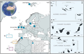
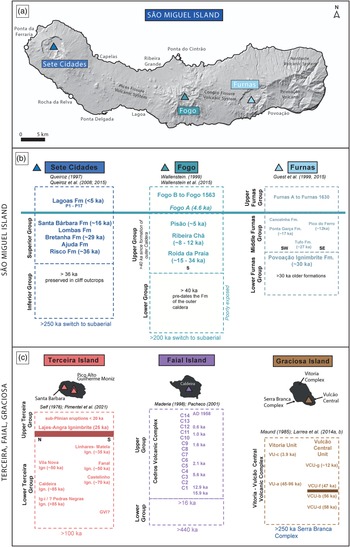

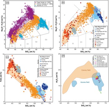
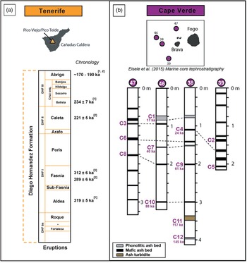


 Open access