


Prelude
One of the long-neglected dimensions of African history is the role of environment in shaping historical experiences of African peoples, which is made more complicated by the reality that human populations are an instrumental part of the environment, constantly reshaping it to fit their needs and oftentimes creating conditions that may no longer sustain human activities. This synergistic and mutualistic interdependence, otherwise studied as historical ecology, presents significant documentation challenges.Footnote 1 For example, we have long been able to document periods of environmental change through various vegetational studies, such as sedimentary records and pollen profiles from lake cores, phytolith profiles from soil samples and marsh cores showing erosional episodes, dry periods, and wet periods. These and many other scientific studies of environmental change provide invaluable information about ancient African landscapes. Much more difficult, however, is linking environmental changes to anthropogenic influences. For tens of thousands of years, especially during the 10,000 years of the Holocene, human populations have altered and modified landscapes significantly.Footnote 2 With the rise of horticulture, pastoralism, and agriculture, ecological transformations accelerated significantly, sometimes leading to widespread deforestation, erosion, and local climatic changes.Footnote 3 The relatively rich history of environmental studies in eastern Africa provides historians with an attractive library of environmental change, though there is a built-in bias that privileges climatic change—dry and wet periods. This bias presents several risks, foremost among them is a deterministic perspective on the impacts of climate change as historians seek to explain how and why various populations responded to these changes.
This study has three objectives: 1) to show how environmental scientists have created narratives that overlook the need for substantiating archaeological evidence and thus endanger historical understandings of African agency; 2) to review historical narratives that use climate-driven perspectives, thus risking the marginalization of how African societies induced environmental change and coped or did not cope with such changes; and 3) to present evidence from western Uganda that employs an interdisciplinary approach to document both climate change and anthropogenic change informed by archaeological evidence.Footnote 4
Issues that Emerge from Environmental Studies in Western Uganda
Environmental scientists have taken the lead in documenting landscape changes, a trend that often creates an uncomfortable need, though, to explain changes that cannot be attributed to climate. The absence of ancillary archaeological evidence has not inhibited speculations about anthropogenic changes. Attempts to link environmental change to human presence first arose with Kendall’s seminal ecological history of Lake Victoria in which he openly speculates that “during the last 3,000 years… forests were greatly reduced, and human activity, rather than climatic change, seems to have been the cause.”Footnote 5 Speculative interpretations gained ground in East Africa with the publication of Hamilton’s study of Ahakagyizi Swamp in the Rukiga Highlands of southwest Uganda, where vegetational change of approximately 4800 BP was represented as human-induced, regardless of lack of evidence for human presence.Footnote 6
David Taylor followed Hamilton’s lead after he observed change of vegetation of about 2200 BP in Muchoya Swamp in the Rukiga Highlands of southwest Uganda, change marked by an abrupt decline of montane forest and the presence of taxa associated with degraded and disturbed soils.Footnote 7 He attributed this change to “the introduction into the area of agriculture and/or iron.”Footnote 8 He admits that there is no evidence for these activities in the Rukiga Highlands at that time yet buttresses his argument by citing archaeological studies as far distant as Engaruka, northeast of Ngorongoro Crater.Footnote 9 Shortly thereafter, Taylor reshaped the original Ahakhgyizi interpretation by suggesting that too much emphasis had been placed on taxa associated with degraded soils, a phenomenon also observed in the Late Pleistocene and Early Holocene histories of Ahakagyizi.Footnote 10 These data compelled the conclusion that Ahakagyizi Swamp as the “centre of unexpectedly early agricultural activity in the Rukiga Highlands now appear[s] erroneous.”Footnote 11 Though we might have expected this reversal to instill greater caution in future interpretive constructs, similar attributions occurred in the Ndali Crater Lakes Region, where Taylor also conducted research at Kabata Swamp (see Figures 1 and 4 for Kabata Swamp and other caldera lakes that have attracted paleoenvironmental research).Footnote 12
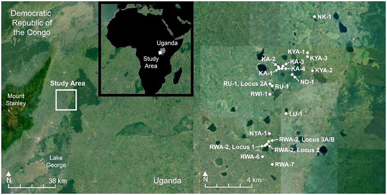
Geographical overview of the research site with the Ndali Crater Lakes Region (NCLR) vis-à-vis the Rwenzori Mountains (left panel) and the distribution of sites within the study area (right panel).
Regardless of the cautionary observations about human-induced change at Ahakagyizi, Hamilton’s initial study continues as an authoritative source for early human-induced changes in the environmental record of eastern Africa. Such speculations have the potential to mislead historians of Africa through reification of non-existent or abstract relationships. Iterations of such positions over time concretize key markers, for instance, the “coming of the Iron Age” as central tropes in historical discourse about environmental change in Africa. One of our goals is to identify such attributions and to replace them with empirical evidence derived from scientific archaeology and ancillary studies.
Issues in Historical Narratives
One of the most comprehensive historical narratives to emerge about East African climate change was published in the Journal of African History about social, political, and environmental changes in western Uganda over the last 2,000 years, particularly during the second millennium CE when complex polities emerged at prominent sites such as Munsa, Ntusi, and Bigo.Footnote 13 Using an integrated approach that blends linguistic evidence with archaeology and environmental studies, Robertshaw and Taylor reviewed environmental evidence from far western Uganda (the Rukiga Highlands, Bwindi/Impenetrable Forest, and the Ndali Crater Lakes Region) to create a picture of environmental change that they then applied to archaeological sites that are 125 km to 300 km distant to the East.Footnote 14 These are enormous distances, especially given the small basins of the sampled marshes are meager proxies for regional change—both climatic and anthropogenic. The small basins are far more sensitive to their immediate environments. This broad-brush approach, in which specific, localized changes from the far western margins of Uganda are generalized to a region greater than 30,000 sq km in west-central Uganda, requires a significant leap of faith that elicits an important caveat from the study’s authors: “we are not advocating strict environmental determinism,” a disclaimer that acknowledges they are perilously close.Footnote 15
This early attempt at environmental synthesis is a milestone publication for African environmental history, and so its assumptions and conclusions deserve examination to set the scene for our discussion about how archaeology, linguistics, and environmental studies may be used to better characterize local landscape changes rather than a homogenizing regional approach. Our starting point is that study’s examination of early settlement by Bantu speakers in Uganda. Notably, only the margins of Lake Victoria are designated as associated with Classic Urewe (Dimple-base) ceramics.Footnote 16 Yet regions as far north as the Victoria Nile once harbored makers of Urewe ceramics,Footnote 17 and the famous site of Mubende Hill and surrounding settlements in west-central Uganda were occupied by peoples who manufactured Urewe Ware in the Early Iron Age.Footnote 18
Given these archaeological observations, it is puzzling why sites from the margins of Lake Victoria were used as proxies for an Early Iron Age presence in the far distant Ndali Crater Lakes Region, which was archaeologically undocumented: the “disturbance of forest around Kabata about 750–550 B.C. and Muchoya swamps about 400 B.C. roughly correlate with the beginning of the Iron Age in the region.”Footnote 19 Archaeological evidence now shows conclusively that iron producers were not close to either Kabata Swamp or any other parts of the Ndali Crater Lakes Region during the early part of the Early Iron Age (500 BCE–200 CE). These examples illustrate the risks of extrapolating evidence from distant locations and assuming that it is pertinent to regions that lack definitive archaeological documentation.
Studies of Early Iron Age sites in eastern Africa show that they are often low-density and thus comparatively difficult to identify during field survey.Footnote 20 Nonetheless, we should expect a map of first millennium CE sites within the Katonga River Basin to include Great Lakes Bantu speakers and later West Nyanza Bantu speakers.Footnote 21 Historical linguistic maps omit the presence of either Great Lakes Bantu or West Nyanza Bantu speakers in what appears to be a large blank zone in west-central Uganda—an omission that incidentally reifies incomplete archaeological attributions for the Early Iron Age in that region.Footnote 22 It is difficult to render an environmental narrative for the region with significant archaeological lacunae, some of which arise from unsubstantiated assumptions of absence.Footnote 23
The small Kabata Swamp caldera is also used as a proxy for a huge region to the east.Footnote 24 When explaining the collapse of major centers such as Ntusi during the 1400s CE in west-central Uganda, we learn that “the major focus of settlement probably shifted to the wetter regions north of Katonga that were more viable for agriculture, the growing importance of which is clear… from the evidence of burning in the core from Kabata Swamp.”Footnote 25 This explanation is based on one isolated datum from Kabata Swamp—burning—used to infer community collapse and then major population shifts to the north of far-distant Katonga River during the second millennium CE. We accept that both archaeological and environmental data were limited two decades ago, yet we must question inferences based on local evidence pertinent to the immediate environs of the studies. Evidence from Kabata Swamp alone cannot sustain sweeping generalizations for distant regions, for example, about the advent of greater moisture in the mid-second millennium CE—namely, “evidence from Kabata Swamp for major forest clearance coincides with the construction of the earthworks [to the East in a distinctively different rainfall zone], the digging of which seems to have been facilitated by surplus agricultural production.”Footnote 26 Here, the reference is to Munsa, Bigo, and other earthwork sites far from Kabata Swamp, without evidence to link the two regions.Footnote 27 We suggest an alternative narrative that recenters our focus on intra-regional changes founded in human and climate associated changes in the environment. For example, we directly target Bigo-period populations around Kabata Swamp and throughout the Ndali Crater Lakes that were engaged in agriculture, pastoralism, and iron production—a more precise environmental story.
Integrated Perspectives on Environmental Change in the Ndali Crater Lake of Western Uganda
We now present evidence that addresses both dimensions of environmental change (climatic and anthropogenic) in a region in western Uganda that borders the Rwenzori Mountains. Known for its lush landscape, reliable tropical rainfall, and rich volcanic soils, this region hosts approximately sixty crater lakes and hundreds of dry volcanic calderas (Figure 2).Footnote 28
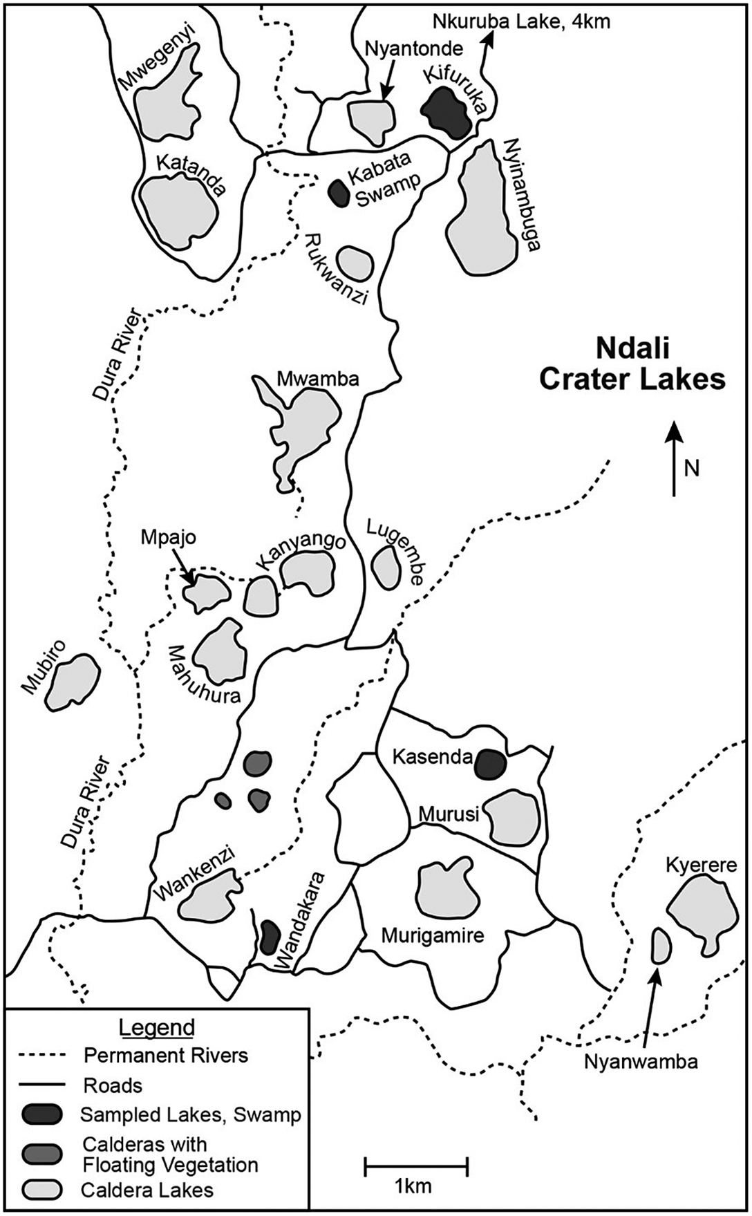
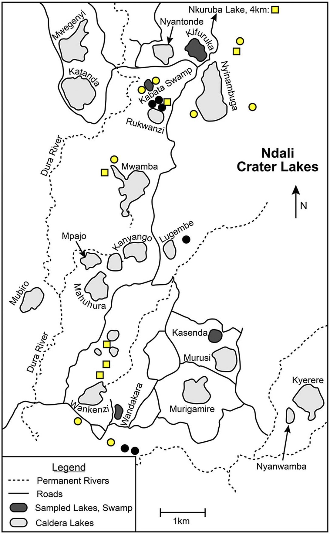
Map of the lakes in the Ndali Crater Lakes Region. Four lakes (Kifuruka, Kasenda, Wandakara, and Nkuruba) and Kabata Swamp have been the focus of multiple studies; they are marked by darker fill. Kabata Swamp and Lake Kifuruka are in the north, Kasenda is central, Wandakara is in the south, and Nkuruba is 4km to the north from the top of the map.
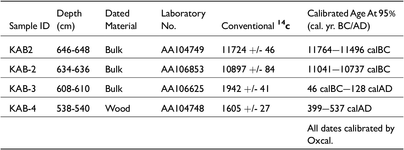
Formed by volcanic activity that dates as recently as 13,000 to 15,000 years B.P.—dates derived during our research from shallow volcanic tuff underlying archaeological deposits we excavated near Kabata Swamp (Table 1, # 1 and # 2)—a region that until recently was terra incognita from an archaeological perspective.Footnote 29 Starting in 1995 with survey and continuing in 2014, 2015, 2019, and 2021 with surveys and excavations in three zones (Figure 3), we have focused on linking environmental change to climate and human agency. This requires a multi-pronged methodology that incorporates archaeological survey to locate and document sites and settlement histories; archaeological excavations to document subsistence activities, technology, chronological patterns of landscape use, and burial and funerary practices; the coring of marshes and lakes to obtain sedimentary records with vegetational and fire evidence; stable isotopic studies showing dietary practices; and historical linguistic postulates about groups in the region during the last 2,500 years.
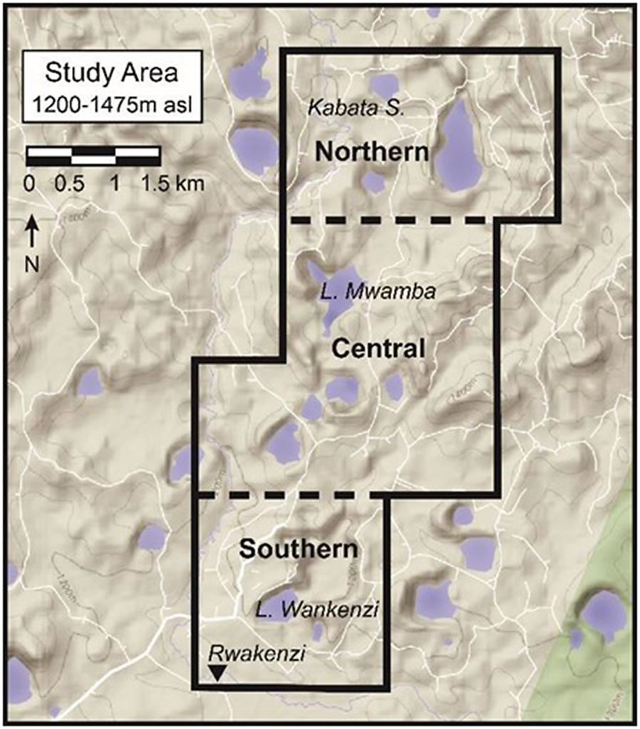
Map showing the perimeters of the NCLR study area and the three research zones.
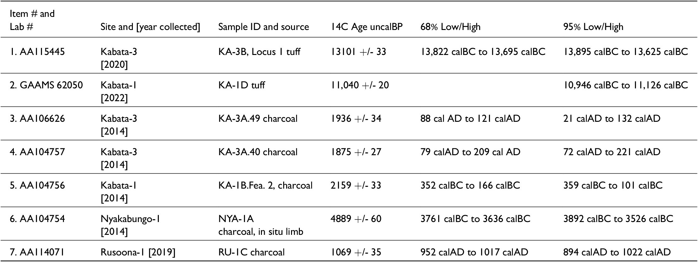
AMS radiocarbon dates of key environmental and cultural events in the Ndali Crater Lakes Region of western Uganda. The 95% level of confidence is a statistical range for each date—found in the far right column and used in the narrative.
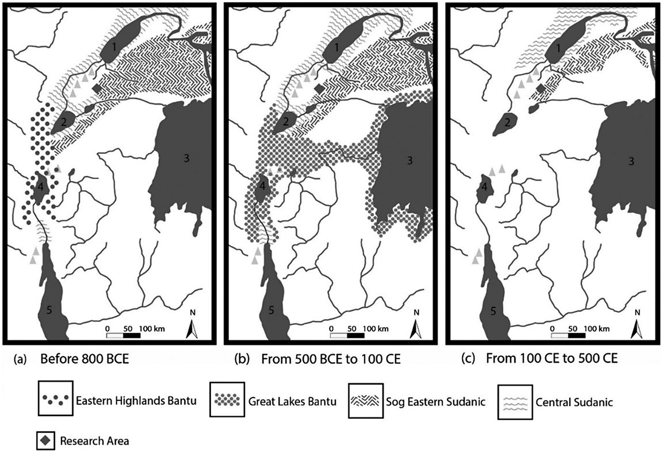
To these forms of evidence, we add environmental knowledge generated over the last four decades by other scientists studying pollen records, diatoms, sedimentary deposits and their isotopic characteristics, and water chemistry. These supplemental studies allow us to fill in lacunae as well as to articulate better the relationships between human settlement, forest modifications, and subsistence practices. Using this transdisciplinary approach, we build a more comprehensive narrative of how people interacted with their environment in the Ndali Crater Lakes Region by examining climate change and anthropogenic changes of the landscape over the last 2,500 years. We start with helpful scenarios painted by historic linguists, who see this zone as initially settled by Central Sudanic-speakers and Sog Eastern Sudanic-speakers by 800 BCE.Footnote 30 While David Schoenbrun’s maps are constructs without definitive borders, they are extremely helpful when juxtaposed to archaeological evidence acquired during the last decade. As Figure 4 shows, Central Sudanic-speakers c. 500 BCE were located on the western and eastern flanks of the Rwenzori Mountains, while the Sog Eastern Sudanic-speakers were located more easterly but also abutting the southern reaches of Central Sudanic-speakers—which is within the scope of our study area. These linguistic configurations are critical to understanding the culture history of the region.
Maps of linguistic distributions before 800 BCE through 500 CE in the Great Lakes Region, from Schoenbrun Reference Schoenbrun1993, 12. By permission of Cambridge University Press.
Archaeological Backdrop
As indicated earlier, this archaeological research is the first to be conducted in the Ndali Crater Lakes Region. We soon came to understand that one of the primary archaeological components in the region was a “culture” known as Kansyore. One of the most significant enigmas of eastern African archaeology is the wide-ranging dates on what is called the Kansyore culture, originally documented and described by Chapman from Kansyore Island in the Kagera River, which separates Uganda from Tanzania.Footnote 31 It is primarily characterized by Kansyore Ware, a distinctive pottery with mostly stamped designs. This important ceramic assemblage remains inadequately dated at Kansyore Island since its initial excavation six decades ago. It was associated with, but not stratigraphically articulated with Urewe and another ceramic type called Boudiné. Thereafter, archaeologists working in western Kenya at a variety of sites documented broadly similar pottery with dates ranging from 7000 BCE to about 300 CE and with huge gaps of thousands of years punctuating the dating scheme.Footnote 32 Using a broad-brush comparative method, these researchers named these sites “Kansyore,” after the stamped motifs that seemed to resemble Kansyore ceramics. Amid this process, Collett and Robertshaw, both archaeologists, observed that the affinities between the Kansyore Island ceramics and those of the western Kenya sites were scant, and importantly that the naming of the latter could not be maintained as Kansyore. They appropriately suggested a local name, Oltome, a term that unfortunately failed to be accepted by their archaeologist peers.Footnote 33 Christopher Ehret saw an opportunity to link historical linguistic arguments to their observation that the Oltome appeared to be related to ceramics documented in southeastern South Sudan at the Lokabulo site.Footnote 34 Ehret posited that historical linguistic constructs for Eastern Sudanic-speakers along the eastern littoral of Lake Victoria in the late BCE and early centuries CE fit the distribution of Oltome ceramics (Schoenbrun refined Eastern Sudanic to Sog Eastern Sudanic in 1993).Footnote 35 With these observations, the scene was set for making connections between Nilo-Saharan-speakers of the north and their presence in Kenya and Tanzania. This background is critical for tracing the origins and cultural attributes of early settlers in the Ndali Crater Lakes Region.
Our surveys and excavations in the region have established that there were six primary cultural complexes—Late Stone Age (LSA, approximately 3600 BCE to 150 CE), Kansyore (150–600 CE), Boudiné (430-540 CE), Transitional Early Iron Age (400–1000 CE), Bigo-related occupations (1300–1650 CE), and Late Iron Age (1650–1800 CE).Footnote 36 Except for the Late Iron Age, all cultural complexes are linked with micro-lithic tools usually associated with the LSA, a phenomenon perhaps tied to specific functions in pastoral life. We also found that the Early Iron Age settlements lacked evidence of in situ iron smelting, constrained by the volcanic landscape and an absence of iron ore. This affirms that speculative assumptions about the practice of iron technology in the late first millennium BCE or early first millennium CE must be set aside as an inappropriate explanation for deforestation in the BCE period. Rather, the Early Iron Age was relatively late (mid-to-late first millennium CE) and not a dominant presence in the larger region when the Early Iron Age was marked by Classic Urewe (Dimple-base) Ware in Rwanda, northwestern Tanzania, the Victoria Nile, and elsewhere in the Lake Victoria watershed. Moreover, iron working in the form of iron forging—with imported raw iron—did not emerge in earnest until Bigo-related people arrived in the region during the thirteenth century CE.
Among our findings was a ceramic ware known as Boudiné, poorly understood in eastern Africa archaeology yet a critical part of the culture history of Ndali Crater Lakes.Footnote 37 Identified 200 km north of Ndali Crater Lakes along the Victoria Nile east of Murchison Falls, Boudiné was documented as stratigraphically contemporaneous with Early Iron Age Urewe Ware.Footnote 38 This relationship places it between Classic Urewe and Transitional Urewe (late Early Iron Age or TU), documented in our study area. Despite its being attributed to Classical Urewe in Rwanda by early investigators, it now appears that Boudiné in Rwanda is contemporaneous with Transitional Urewe (as it is at the KA-1 and KA-3 sites in Ndali Crater Lakes), showing similar traits in fabric.Footnote 39 Boudiné in the Ndali Crater Lakes Region, however, shows greater affinities to Kansyore than to Classic Urewe, the latter absent from our assemblages.Footnote 40 In the Ndali Crater Lakes Region, it should now be seen as part of the Transitional Urewe that developed out of interactions with those producing Kansyore ceramics during the mid-first millennium CE.
Environmental Studies and Archaeology, Ndali Crater Lakes Region
Environmental research in the Ndali Crater Lakes began in 1995 with coring in Kabata Swamp, the same year as archaeological surveys in the same vicinity located many occupation sites ranging across the time periods just discussed. The Kabata core presented challenges, as it contained significant hiatuses in sedimentation between 11,000 years ago and approximately the first millennium BCE. Despite this, the pollen evidence from approximately 1,000 to 500 BCE indicated significant forest clearance, soil degradation, and the proliferation of grasses, interpreted as the presence of Bantu-speakers who were iron-producers engaged in forest clearance for agricultural purposes.Footnote 41 The authors acknowledge that the evidence for Early Iron Age communities in western Uganda is sparse at best, thus making it difficult to attribute forest clearance to their presence. With a deficiency of archaeological evidence to buttress an argument for Early Iron Age, iron smelters on the western shores of Lake Victoria approximately 500 BCE were used as proxies.Footnote 42
The western Tanzanian scenario and earlier dates from Rwanda and Burundi, also cited, do not apply to Kabata Swamp and its environs or to the Ndali Crater Lakes Region. Interpretation of the pollen record from the 1995 core uses inference to suggest a beginning date of 500 BC in western Uganda rather than substantial local archaeological evidence. The 2000 Kabata report also included speculations about how environmental change occurred during the mid-second millennium CE, when another deforestation episode and high frequencies of charcoal were observed from approximately 1400 to 1650 CE. These changes are attributed to the incursion of Ntusi- or Bigo-related peoples, without sustaining archaeological evidence. This proved to be a prescient speculation that now fits our archaeological evidence for that period. At that time, however, it was not a viable hypothesis. Archaeological evidence for Bigo-related settlements in the Ndali Crater Lakes Region shows settlements starting about 1300 CE, climaxing at approximately 1450–1500 CE, and showing resilience until about 1650 CE.Footnote 43
Our integrated approach, blending environmental research with archaeological research, avoids inference and leads to verifiable conclusions. Our initial archaeological survey data highlighted the Kabata Swamp area as a priority zone for in-depth investigation (Figures 1 and 2). When our team began excavations in 2014, we focused on a suite of four sites around Kabata Swamp and targeted the re-coring of Kabata Swamp with the goal to document the phytolith and charcoal records among other evidence, such as diatoms.Footnote 44
Our initial archaeological investigations at the KA-1 site produced evidence for LSA, Kansyore, Boudiné, Transitional Urewe, Bigo, and later occupations—a “multi-component site” in archaeological terminology. The presence of only a few pieces of forging slag from the Bigo period and the absence of Classic Urewe ceramics confirm that forest clearance in the first millennium BCE occurred neither due to the presence of iron production nor from Early Iron Age settlement. As our investigations turned to other sites, we expanded our understanding of the area’s landscape history. In fact, 250 meters to the east of the KA-1 site we documented the KA-3 site with many lithic artifacts, including LSA microliths (see Figure 1). Excavations at KA-3 established there was a pre-ceramic LSA presence associated with forest burning. Within the stratum containing LSA lithics were two burning episodes, with radiocarbon dates from the early first century CE and, stratigraphically higher, the second century (Table 1, # 3 and # 4).Footnote 45 The limb-like charcoal fossils are evidence of forest clearance directly associated with the LSA, immediately followed by Kansyore ceramics. These associations testify to purposeful forest clearance linked to environmental evidence.
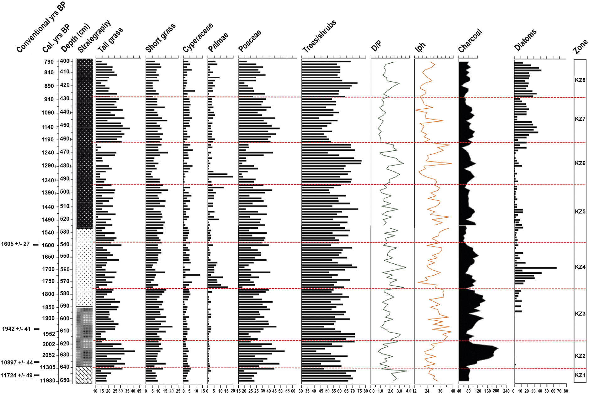
Turning to the environmental evidence from our Kabata Swamp core, we see in the last four centuries BCE a significant pulse of charcoal deposition over several hundred years (Figure 5, Zone KZ2; Table 2). It is improbable that continuous forest fires account for this; rather, it is sustained forest clearance by human agents. At the same time, tall grass (C3/C4) morphotypes dominated grasses, making up 40 percent of the assemblages. Coeval with these changes is a significant drop in forest taxa. The associated changes in grasses, charcoal deposition, and forest taxa point convincingly to human impact on environment for settlement and agricultural purposes.Footnote 46 These changes tie in nicely with burning evidence found at the KA-3 site and with a fourth-century BCE radiocarbon date on charcoal at the KA-1 site (Table 1, # 5), sampled from the top of the subsoil.
AMS radiocarbon dates for different sediment levels at Kabata Swamp in the NCLR. The conventional bp (before present) dates in column 5—also used in Figure 5—are calculated from 1950, which represents present. The 95% level of confidence dates in column 6 are used to frame the historical discussion.
Profile of sedimentary record and association AMS radiocarbon dates, 2014 Kabata Swamp core. Schmidt at al. “Remaking Late Holocene.”
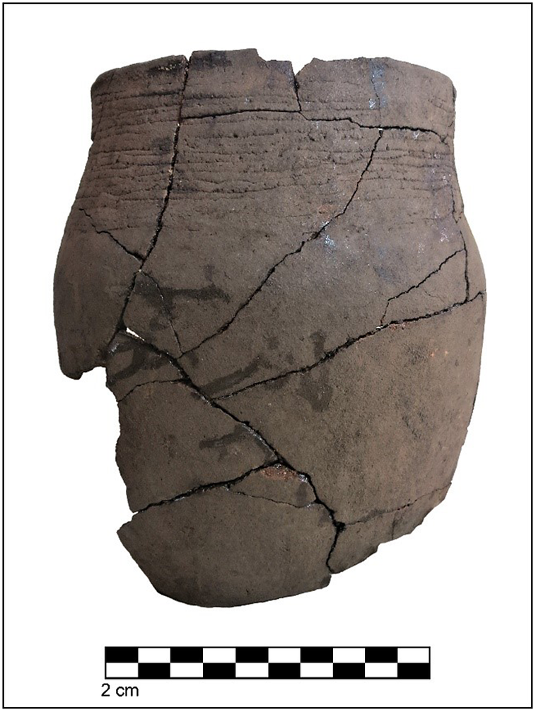
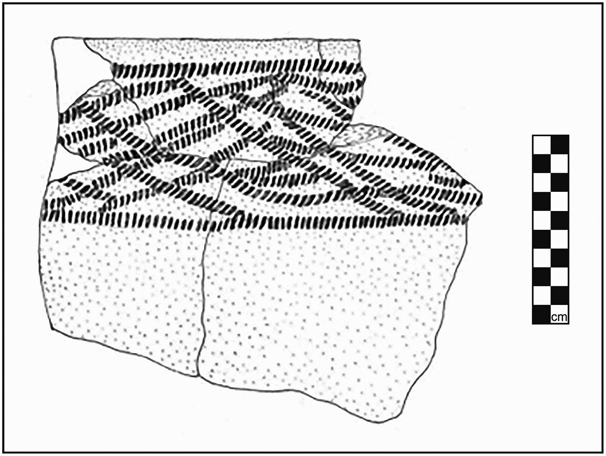
Excavations at the KA-3 site in 2021 successfully documented Boudiné Ware to the mid-fifth to mid-sixth century CE (Figure 6), with an AMS date from an infant burial inside another large vessel.Footnote 47 This direct association of Boudiné with funerary practices is also seen at the KA-1 site and the KA-4 site, where urns were placed with burials. While many of the Boudiné vessels at KA-1 were displaced from their original setting by deep hoe agriculture, they were nonetheless found with artifacts, such as beads made from the Giant African Snail (Lissachatina sp.) and elephant ivory, alongside a decorated ivory pendant and bracelets.Footnote 48
A Boudiné vessel recovered from the KA-3 site in 2021 by Jackline N. Besigye. Schmidt et. al. “Remaking Late Holocene.”
An AMS date on a burial associated with a Kansyore funerary vessel falls in the early fourth to early sixth century CE at the RWA-2, L3 site northwest of Lake WankenziFootnote 49 What we take away from these results is that ceramics closely related to those of Kansyore Island mark the presence of peoples practicing this ceramic technology alongside lithic production in the early first millennium CE and, a couple of centuries later, alongside people making Boudiné Ware in both domestic and funerary settings. What also emerges is that the manufacturers of Boudiné Ware mimicked Kansyore ceramics, with similar clays, tempering materials, firing temperatures, and decoration on vessel bases.
These associations strongly suggest a purposeful and conscious attempt to accommodate the Boudiné makers’ material culture to a dominant culture in the region. We believe, given our observations for syncretism expressed in ceramics, in addition to the cultural associations documented by Soper, that the Boudiné-makers were of West African origin (i.e., Bantu speakers) and that the Kansyore folk were Central Sudanic-speakers from the north. This is affirmed by strong ceramic affinities between the Kansyore of Ndali Crater Lakes and the Jehel Tukyi site in Western Equatoria, southern South Sudan.Footnote 50 These strong affinities—linking Jehel Tukyi to Ndali, Kansyore Island, and Central Sudanic-speakers—help to explain the significant differences that the western Ugandan Kansyore ceramics have vis-à-vis Oltome Ware of western Kenya and its connections to Sog Eastern Sudanic-speakers and the Lokabula site in Eastern Equatoria.Footnote 51 Though Soper did not document Kansyore sites during his short reconnaissance along the Victoria Nile, his study alerts us to a Bantu-associated transition from Urewe to Boudiné—a coeval shift that sets the stage at Ndali Crater Lakes, where Boudiné appears alongside Kansyore with variations that show close interactions and dense, multi-group occupations (Figure 7).Footnote 52
Map of the distribution of Kansyore and TU/Boudiné sites in the study area of the Ndali Crater Lakes. The squares are Kansyore sites while the circles are Kansyore sites with a TU/Boudiné component. The open or yellow circles and squares are excavated sites. Locations are based on a 15 percent sample within the study area,
When we juxtapose these findings to historical linguistics, a compelling scenario arises: Schoenbrun’s linguistic map shows that the Bantu movement eastward would have encountered Central Sudanic-speakers on the western flank of the Rwenzori Mountains at approximately 800 BCE. Thereafter, most of the Great Lakes Bantu movement into eastern Africa was south of the Rwenzori Mountains—not to the north, where they would have met central Sudanic speakers who, already ensconced on the landscape, practiced a mixed economy that included agriculture, pastoralism, fishing, and likely hunting. The few Bantu-speakers who entered the region—likely some centuries after they first arrived west of the Rwenzori Mountains—from Lake Albert to the Ndali Crater Lakes faced a dominant, established culture with a different language and life ways. In such circumstances, displacement did not occur. In fact, historical linguistics show a significant amount of borrowing from Central Sudanic by Bantu-speakers.Footnote 53 What we imagine happened is that the relatively few Bantu-speakers who slowly leaked around the northern Rwenzori Mountains (some making their way along the Victoria Nile) accommodated their material culture and life ways to the dominant group, using ceramic technology as one of their means to negotiate a new identity.Footnote 54 We may compare them to the contemporary Luo of Kenya who speak a Nilotic language yet genetically are predominantly West African, that is, originally Bantu-speakers.Footnote 55
Refocusing on Environmental Evidence
The archaeological evidence, then, sets the stage for a better understanding of the environmental data that emerge from our Kabata Swamp core and other evidence from the immediate area. The sedimentary profile from our project’s inquiry at Kabata Swamp shows a similar hiatus in deposits observed in the 1999 study, a phenomenon perhaps explained by peat mining for fuel during an earlier dry period or burning caused by volcanic eruptions 4,000 years ago in the Fort Portal area to the north.Footnote 56 The charcoal evidence first captures our attention, with significant charcoal transported into this basin during the 100 BCE to 400 CE era (Figure 5, Zones KZ3 & 4).Footnote 57 These frequencies fit closely with the forest clearance episodes at the KA-3 site and the occupational evidence at both the KA-1 and KA-3 sites and elsewhere in the region. The increase in charcoal parallels a significant decrease in nearby forests. When both proxies for change are considered, then their association with Kansyore utilization of the environment is significantly strengthened. The diatom record for the latter part of this period (Figure 5, Zone KZ4) shows increased moisture, a condition that may have initially attracted a mixed pastoral-agricultural-hunting-gathering economy to the region from the dryer steppes of the southern South Sudan, when a drying phase at the change of the millennia may have been one factor that encouraged people practicing a mixed economy to move southward to a moister Ndali Crater Lakes refugium.
Evidence for a more significant presence of peoples related to those of Kansyore Island draws from a series of three burials on the northwestern rim of Lake Wankenzi in the southern sector of the study area. The burial of a robust woman at RWA-2, L3A was associated with a large vessel with Kansyore-stamped designs and with a decorated flat, heavy base resembling Boudiné funerary vessels (Figure 8).Footnote 58 The diets of this woman’s Nilo-Saharan-speakers contemporaries incorporated a mix of wild plants with domesticated plants such as grains and beans. The agricultural part of the diet is important; the cultivation of crops within tropical forests would have required significant forest clearance—a swidden or slash-and-burn activity. We see precisely that type of impact from 300 to 400 CE (Figure 5, upper Zone KZ4) when charcoal deposition reaches a high frequency, followed by another burst of charcoal from 400 to 500 CE (Figure 5, mid-Zone KZ5), the latter when both groups who produced Kansyore and Boudiné ceramics were in the region (Figure 7). This overall archaeological record shows increasing social complexity and multilingual communities during the mid-first millennium CE.Footnote 59
A line drawing of the top of a large Kansyore funeral vessel from the RWA-2, Locus 3A site. The converging stamped lines are a decorative marker for large storage vessels of that occupational period. Schmidt et al. “Remaking Late Holocene.”
The Kabata Swamp core also captures a post-Kansyore and post-Boudiné phase at about 550 to 750 CE, during which there are increased proportions (50 to 75 percent) of forest taxa (Figure 5, Zone KZ6; Table 2). This is a period of significant forest recovery and diminished grasslands that corresponds to reduced settlement evidence for the Kansyore culture in the region.Footnote 60 This alignment is a dynamic fit between the environmental record and the archaeological evidence—a period of landscape recovery for two hundred years before an abrupt increase in grasslands and decrease in forest taxa, plus a significant increase in charcoal frequencies from 750 to 1000 CE. These converging changes in the environment cannot be tied to any drying period or arid events in eastern Africa. Rather, the changes appear to be linked to the presence of folk responsible for Transitional Urewe, dated west of Lake Victoria to 600 to 1000 CE, as well as to Nilo-Saharan-speakers who utilized the region for seasonal pastoral purposes.Footnote 61 The Kabata Swamp core data end shortly thereafter and do not capture the second millennium CE history of the region. For that history, we turn to other investigations.
Developing a Comprehensive Regional Perspective
The frequency of early first millennium CE sites on the rims of caldera lakes shows a preference for these settings with good viewpoints, proximity to water, and breezes. The check-to-jowl relationship of settlements to lakes inspires confidence that the environmental records in lake and marsh sediments are more likely to capture the immediate watershed/basin. While the documentation of genera and species of trees in the nearby Kibale National Park provide good proxies for the Ndali Crater Lakes Region, each crater lake appears to harbor its own micro-forest environment.
Part of our regional strategy was to draw information from other lake basins to assess variation across the landscape, with another team focusing on Kifuruka Lake, only 1 km to the northeast of Kabata Swamp.Footnote 62 Given our prior surveys and excavations in 2014, this nearby lake core might be expected to provide a good index for anthropogenic change. This findings at Kifuruka deserve analysis vis-à-vis other environmental and archaeological evidence. The first evidence of note is the bottom of this core shows significant forestation 11,500 years ago, which accords well with data from Kabata Swamp. The first significant change in the record comes at about 2350 BCE, when forests supposedly diminished with a decline of Podocarpus and the finding of one Cerealia pollen grain, interpreted as marking possible cereal agriculture. The investigators note other information from eastern Africa that documents a drying episode during this time, an observation that the 1999 Kabata study also highlights as a more likely explanation for forest decline. The pollen profiles, however, show a diminution of forest at least two thousand years earlier. While wild grasses may produce Cerealia-like pollen, this caution is set aside to privilege agriculture, without human evidence to underwrite it. We have archaeological evidence for LSA populations that dates to the early fourth millennium BCE elsewhere in the region (Table 1, #6), but the light footprint of human presence in the Ndali Crater Lake forests at that time cannot be tied to environmental changes then or during the late third millennium BCE period documented at Kifuruka.Footnote 63
The central argument emerging from the Kifuruka study is that at approximately 500 BCE there is a decrease in forest taxa, paralleling the 1999 Kabata Swamp findings. The authors attribute this change to forest clearance caused by iron smelters. We know that iron smelting cannot be responsible for this change, nor agriculture associated with iron-producing people colonizing the forest. The study’s interpretation of Cerealia pollen may be appealing but must be rejected because the significantly low-resolution data are not associated with the Early Iron Age activities they claim, viz: “The frequent fire events at the shores of Lake Kifuruka are further evidence of human impacts on the landscape. It is reasonable to expect such anthropogenic impacts as these zones temporally span the Iron Age, with the Early Iron Age (ca. 500 BC to AD 600) marked by an unequivocal agricultural economy, iron production and more permanent villages.”Footnote 64 This attribution misidentifies the agents of anthropogenic change, ignores anomalously stable forests, and fails to pinpoint important pulses of change in the material record. Using archaeological data, we know that forest clearance was underway during the last century BCE/first century CE by people using lithic implements, a process that may well have been in train several centuries earlier. Rather than seek iron technology as an explanation, it is compelling instead to attribute it to lithic-using populations. Given Schoenbrun’s historical linguistic reconstructions, there were Central Sudanic-speakers in the region cultivating cereals, such as sorghum and pearl millet, in their subsistence repertoire alongside tending domesticated animals, such as cattle and sheep, but at such a light density that their presence is ephemeral or only marked by lithic tools.Footnote 65
Additional examination of the Kifuruka core importantly reveals a high frequency of charcoal at approximately 300 CE, when Kansyore peoples are settled in this area, practicing a mixed economy, and burying their dead upon crater rims. Charcoal deposition again peaks at approximately 550–600 CE, when both Kansyore and Boudiné populations are present with significant settlements. This evidence agrees with our Kabata Swamp findings and points to anthropogenic changes induced by these populations, not Early Iron Age folk. Another pulse in charcoal frequencies between 750 and 950 CE—its importance as yet unacknowledged—may be attributed to the Transitional Early Iron Age and the environmental impacts induced by its population, a key association missed because archaeological evidence was not incorporated into previous interpretations.Footnote 66 This period of anthropogenic change is a primary point of agreement with our Kabata Swamp findings for understanding the impact of human populations on environments in the region. The Kifuruka study also shows that forests recovered and persisted throughout the period of Kansyore and Boudiné occupation, c. 200 to 600 CE, a highly improbable history. Significant settlements of both populations on the landscape would leave an easily discernible environmental signature—an error that is apparently again the result of low-resolution analysis. Our core from Kabata Swamp shows increased diatoms and thus greater moisture with deforestation and the growth of grasslands (Figure 5, Zone KZ4). In other words, the analysis of the pollen record at Kifuruka does not capture the vegetational dynamic of anthropogenic changes in the immediate region, likely a sampling issue—not an accurate capture of landscape change through time.
Also anomalous in the Kifuruka data is the significant change from 60 to 35 percent forest cover from approximately 550 to 750 CE, a period at Kabata Swamp marked by forest regeneration. The researchers do not attribute this to either climate or human-induced causes. The data lack sufficient resolution and command over archaeological information to inspire confidence in its interpretive narrative. Dating at the top of the Kifuruka core is not precise, though a steady depositional record would place the next major forest fire proxy at approximately 1300 CE, when our study sees Bigo-related peoples began to saturate the region with dense agricultural settlements, a detail that agrees with the 1999 Kabata data.
The Kifuruka lake core has been re-analyzed with a focus on fungal spores.Footnote 67 The presence of Sporormiella-type and Sordaria-type fungal spores is attributed to herbivores at approximately 2350 BCE, a claim that is impossible to link to either wild or domesticated animals and thus overreaches to explain significant forest decline. Moreover, the authors suggest that the presence of Chaetomium spores, documented by others as connected with human habitation, “supports that the clearance of arboreal vegetation at about 4300 cal yr BP… promoted grasses and herbaceous vegetation and was indeed a product of deforestation by humans.”Footnote 68 Human agency is introduced abruptly to explain forest decline, an opening of the environment to grasses and herbivore grazing—a complex chain of events that is speculative and unsubstantiated, weakening the effort to forge multi-proxy explanations. There is no archaeological evidence from this area to suggest that forest decline and grazing animals are linked to significant environmental change that is anthropogenic, analysis conducted in isolation from historical and archaeological knowledge. The Kifuruka investigators also err significantly when they mischaracterize the coming of Bantu-speakers to eastern Africa: “For a long time, linguistic and archaeological evidence was used to argue for a kind of wholesale and all-encompassing Bantu agricultural/pastoralist expansion into East Africa between about 4500 and 3000 years ago” (emphasis added).Footnote 69
Greater confidence in fungal spores being linked to human presence and grazing animals occurs during a period from about 10 BCE for a half millennium, when dung-related (Coprophilous) fungi show high frequencies at the same time the region is populated by agricultural-pastoral-hunting populations. This evidence corresponds nicely with our archaeological evidence from the KA-3 site, with its documented burning activity and presence of LSA peoples as well as the widespread presence of Kanysore sites. Regrettably, an Iron Age trope is invoked to explain this environmental change at Kifuruka: it “falls archaeologically in the Early Iron Age, a period marked by a rise in agricultural activities and iron smelting technology that was wood intensive, both of which are understood to have led to major broad social changes.”Footnote 70 Thus, with an informed archaeological data set, we can use other studies to discern critical moments of change, even though their interpretative narratives may often be unsubstantiated and inaccurate.
Reprising the Transitional Urewe (TU)
More nuances are added to our first millennium scenario from Kasenda Lake located in the center of our study area. The pollen record there indexes a period from 750 to 900 CE during a wet period that yields significant charcoal from local fires and Ricinus pollen indicating deforestation, suggesting “increased erosion and increasing gaps in the forest, most likely related to human activity.”Footnote 71 These findings agree well with our results at Kabata Swamp. In yet another study of Kasenda Lake, a forest decline occurs from 900 to 1000, which is a change attributed to possible aridity, and unfortunately suggesting that this change may relate to “the onset of the later Iron Age in western Uganda.”Footnote 72 We see the onset of arid conditions around Kasenda as inhibiting significant Transitional Urewe occupation in the area—helping to explain the relatively light TU footprint in the southern part of our study area. As mentioned earlier, this is a period during which similar changes are documented at Kabata Swamp and Lake Kifuruka, both of which we specifically tie to the TU, not the Late Iron Age (about 1500–1800 CE). The steep sides of Kasenda Lake are still forested, suggesting that its inaccessible physical characteristics may have been less subject to catchment changes until late in the agricultural incursions of the TU period.
Archaeological research shows the presence of late Early Iron Age peoples (TU) in the region in the latter half of the first millennium CE. We have evidence from the Rusoona-1 site for TU presence in the tenth century CE (Table 1, # 12), as well as comparative evidence from western Tanzania and western Kenya that suggests that the TU of the Ndali Crater Lakes fits into a larger regional framework of the late first millennium CE.Footnote 73 The TU footprint is stronger in the northern part of the region, particularly around Kabata Swamp and Lake Mwamba, with TU communities located on caldera rims and thus contiguous to lakes and swamps. The proximity of settlements to lakes and swamps heightens confidence that their significant landscape transformations are captured in the nearby sampled environmental records. Southern TU period burials have not been located, suggesting a lower population profile compared to the Kansyore and Bigo periods.
Among our archaeological findings is sparse evidence for human presence on the Ndali landscape from approximately 1000 to 1250 CE. This is not surprising; the Kasenda Lake history and other trends across western Uganda point to an oscillating climate history between 900 and 1600 CE, with significant wet periods at approximately 1000 and 1400 CE at both Kasenda and Wandakara Lakes, punctuated by some aridity after 1100 CE and in general until 1600 CE, a nuanced history that does not correspond neatly to the Little Ice Age, which is usually attributed to 1500 to 1800 CE.Footnote 74 Others generalize this period across eastern Africa as experiencing aridity from 1000 to 1200 CE.Footnote 75 The particularities of both local climate and human interaction with the landscape caution us to remain focused on the local while remaining cognizant of broader climate trends.
Archaeological evidence from 1000 CE to 1200 CE is limited to two burials, one located on the western rim of Lake Mwamba (eleventh century CE), and another located on the western rim of Lake Wankenzi (twelfth century CE).Footnote 76 Both burials are not associated with TU materials, nor do we find any occupation sites that can be attributed to this era. This finding suggests that the burials are of individuals, possibly transhumant pastoralists, who utilized the region for its marginally better moisture. The Ndali Crater Lakes are particularly sensitive indices to major climatic perturbations, such as the Medieval Climatic Anomaly of the northern hemisphere, with clear aridity signatures captured in these small basins.Footnote 77 The hiatus in permanent human settlements from 1000 to 1250 CE may be linked to this global climate event, though the region would not have been as severely impacted as eastern regions, such as the Lake Navaisha basin.Footnote 78 In fact, this arid period is made more complex by a gradient of severe aridity running from eastern to western East Africa.Footnote 79 The increased aridity of the eastern reaches of East Africa may have been a driver for those practicing pastoral-based economies to seek more sustainable settings in the Ndali Crater Lakes Region, initially in the form of transhumant pastoralism with some low-rainfall cropping, which left an ephemeral footprint in the area.
The Second Millennium CE
As we try to gain greater specificity in the links between human groups and environmental change, we turn to one of the few studies that addresses short-term climate change in the region documented in a more sensitive small lake reservoir—Nkuruba—in the northern-most reaches of the Ndali Crater Lakes region. Due to its well-preserved forest and wildlife, Lake Nkuruba has been the subject of multiple scientific studies, ranging from primate inventories to oxygen levels and sedimentary histories. Among the more informative sedimentary studies is an examination of well-preserved sedimentary pigments that provide a reliable proxy for climate change on a decadal scale up to a millennial scale.Footnote 80 Because ideal depth, water chemistry, and anerobic conditions are found at Lake Nkuruba, it is ideal for sorting out climate change from anthropogenic change using sedimentary pigments and ancillary evidence. Broad-brush treatments of East African climate, with a focus on arid conditions associated with the Medieval Climatic Anomaly, show broadly similar trends but, more specifically, that Lake Edward, 80 km to the south, experienced a significant drought pulse starting at 1050 CE.Footnote 81 These generalized characterizations are risky to extrapolate from large catchments and gradients across vast geographical regions “to infer climate impacts on local ecosystems.”Footnote 82 Much finer grained analysis from lakes, such as Nkuruba, illustrate more rapid and dynamic changes.
The Nkuruba Lake study establishes a significant drying episode during the second half of the thirteenth century CE (1250–1300), with decreased water content and organic matter values in the core, accompanied by crater walls without vegetation and increased snail frequencies (which normally are found in shallow littoral waters).Footnote 83 This climatic perturbation occurred at about the same time that the first Bigo period immigrants were settling the region. For the drier central-western portions of Uganda, where the Bigo and Ntusi sites were located, this intense short-term change likely encouraged movement to moister localized conditions in the Ndali Crater Lakes Region (which also was impacted significantly but not at the level of severity as the drier central-western zone of Uganda). The Ndali Crater Lakes appear to have become a refugium for agropastoralists escaping desiccated pastures and agricultural plots.
The difficulties of linking climate changes among the Ndali Crater Lakes is witnessed in the Kasenda catchment, where there was increased moisture at about 1400 CE, somewhat later than the 1300 CE return of high moisture at Lake Nkuruba to the north, where a return to moist conditions replicated increased water levels in Lake Victoria and Lake Edward.Footnote 84 Importantly, both the Nkuruba and Kasenda records show moisture conditions that would have been attractive to sustain dense Bigo-related settlements on the Ndali Crater Lakes landscape (Figure 9).
Map of Bigo period sites in the NCLR, graduated by approximate size: the smallest circle is a site of 0.1 to 0.5 ha; the medium circle is a site of 0.5 to 2.5 ha; the large circle is a site greater than 2.5 ha. Open or yellow circles are excavated sites.
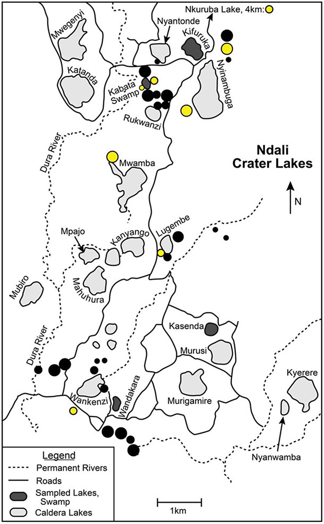
Large Bigo-related sites are omnipresent on the landscape, usually occupying deep soils on caldera slopes or on high and flat caldera rims. For example, a large multicomponent site with a prominent Bigo occupation is located on a high ridge 1.5 km to the east of Lake Nyinambuga. The site includes a deep refuse pit with domestic cattle and goat/sheep bones dated to the late -fourteenth to late fifteenthcentury CE.Footnote 85 A Bigo-related burial dating to the same century lies within this large site.Footnote 86 The picture that emerges from these multiple points of evidence is a landscape saturated with large agricultural/pastoral communities who practiced manuring of crops and extensively cleared forest, thus propagating grasslands and contributing to soil degradation and lake pollution. Environmental data from both Lake Kifuruka and the 1999 Kabata Swamp study confirm significant burning activity and the dominance of grasslands during the mid-second millennium CE, but the most significant environmental evidence to emerge for impacts of Bigo-related communities comes from Lake Wandakara (see Figure 9). Located 400 m to the southeast of Lake Wankenzi and close to multiple, significant Bigo-related sites, the southern slopes of Lake Wandakara today—like its neighbor Lake Wankenzi—are marred by intense agriculture, from the caldera rims to the waterlines. Satellite imagery shows that both Wankenzi and Wandakara have serious algae blooms, with Wandakara being more affected by nutrient runoffs from agriculture disturbance and associated manuring.Footnote 87 The conditions today in Wandakara appear to be a strong proxy for what occurred during the mid-second millennium CE.
One of the more innovative approaches to caldera lake histories in the region occurred at Lake Wandakara, where compound stable isotope indicators were used to assess both climate change and human-induced impacts on terrestrial vegetation.Footnote 88 Isotopic analyses of Wandakara sediments show an “increased flux of isotopically enriched N from the landscape during conversion of forest to grassland.”Footnote 89 The analysis of Oxygen isotopes leads to the deduction that “the enormous amplitude of shifts in δDC30 relative to δD C16 likely results from the replacement of forest with C4 grasslands during wet periods—a process driven by humans rather than by climate.”Footnote 90 Though Russell and his colleagues favor human agency for changes in C4 vegetation that begins at about 1000 CE, they include the possibility that “an abrupt increase in the abundance of C4 vegetation… could reflect either replacement of forest by C4 grasses, or the local establishment of sorghum and millet farming.”Footnote 91 These conclusions must be tempered by the absence of significant human populations during this period—pointing to replacement of forests without human agency. A significant finding is the return of wet conditions from 1200 to 1450 CE when there are abrupt changes in the C/N ratios and δ15Norg.Footnote 92 Significantly, the combined effects of increased rainfall with intense human use of the Wandakara catchment from 1250 onward resulted in “the eutrophication of Lake Wandakara.”Footnote 93 This study presents the most definitive analysis of anthropogenic change in western Uganda, a record that shows biogeochemistry to be much more sensitive to human activities than climate, conclusions that connect strongly to archaeological evidence for the same period.
Conclusions
As we have observed, environmental scientists often seek imagined anthropogenic explanations when climate change does not fit changes in environmental records. This approach is conjoined with historical narratives that often overreach the limits of local environmental records to create inferred scenarios that cannot be substantiated by archaeological or linguistic evidence. We have now hopefully moved beyond both forms of supposition to build substantial relationships between environment and human presence on the landscapes of western Uganda. Archaeological evidence is critical for underwriting inferences from either perspective—either affirming or denying their viability. In the case of the Ndali Crater Lakes, Schoenbrun’s mapping of Central Sudanic presence along both flanks of the Rwenzori Mountains is significant in helping to unwrap an interaction sphere dominated by Nilo-Saharan-speakers but also penetrated by later Bantu-speakers who accommodated to the local culture—both together contributing to a period of major environmental change with permanent villages where both agriculture and pastoralism were practiced alongside hunting and gathering. The environmental imprint left by the Kansyore and Boudiné-related people is indelible.
Conventional and once-favored explanations for environmental change in the region attributed to Early Iron Age iron production can no longer be sustained. This necessitates a shift away from simplistic causes and characterizations. Based on the evidence, later Early Iron Age people associated with TU ceramics are also key actors in effecting landscape changes before a period of aridity that feature a minimal human presence from 1000 to 1200 CE, when transhumant pastoralists may have been present. Finally, multiple environmental studies and rich and detailed archaeological evidence for Bigo-related communities practicing iron working help to explain major transformations in the Ndali Crater Lakes landscape that end at approximately 1500 to 1650 CE,Footnote 94 with degraded soils and nutrient pollution of lakes that once sustained those populations.
Supplementary Material
To view supplementary material for this article, please visit http://doi.org/10.1017/hia.2023.6.
Acknowledgements
We are indebted to the assistance provided by the local authorities in Kibarole District as well as help provided by local citizens. We received funding from the University of Florida, the National Science Foundation, PAST, and the National Geographic Society. Research was conducted with permission from the National Museum of Uganda and the Uganda Commission for Science and Technology. We thank members of our team, particularly John Krigbaum, Raymond Asiimwe, Gilbert Oteyo, Jane Schmidt, Amon Niwahereza, Asmeret Mehari, Charles Okeny, Doreen Yeko, Catherine Ajiambo, Gonzaga Mutudi, Katie Bermudez, Rebekah Zinzer, and many others who assisted in the field, laboratory, and elsewhere. We are grateful for help from Aubrey Price at Ndali Crater Lodge and the management of Nkuruba Nature Reserve.


 Open access