

Introduction
The mountain ranges of British Columbia and western Alberta, Canada, are characterized by vast spatial areas with a mix of snow and avalanche climates. The data used in this study are based on the information exchange (InfoEx) service of the Canadian Avalanche Association (CAA). To facilitate data exchange among avalanche safety programs, the CAA has been managing the InfoEx since winter 1991/92. Every evening during the winter season, contributing safety programs send their observations to the CAA. Their reports generally contain weather data from study plots and/or field observations, general comments about observed snowpack characteristics, detailed avalanche observations including comments about weak layers, and stability ratings for the three elevation ranges “alpine” (ALP), “tree line” (TL) and “below tree line” (BTL). The data are compiled by the CAA and redistributed before the next morning as a comprehensive bulletin to all subscribers by file transfer protocol, e-mail or fax. To receive the confidential information, individual safety programs pay an annual fee and have to contribute their data to the exchange. InfoEx subscribers are back-country ski operations, highway and rail safety programs, ski resorts, parks and a few mine and logging operations.
In this paper, we present a first analysis of this dataset. We focus on the analysis of the weather data in comparison to the snow stability ratings and the reported weak layers over the whole area. The goal is to obtain further insight into the link between snow climate and the resulting avalanche hazard characteristics.
Data Description and Analysis
InfoEx bulletins have been archived by the CAA as text files. While weather observations are presented in a table structure, the majority of the snow and avalanche observations are reported in semi-structured comments. In order to use these data for scientific purposes, the information had to be transferred into a relational database. A parsing code was developed based on flex/bison technology (Reference Levine, Mason and BrownLevine and others, 1992). This enabled recognition of the structure within the text files and the sorting of the information into tables. The following tables are now available: (a) weather observations at base stations; (b) field weather observations; (c) stability ratings; (d) avalanche observations; (e) skied or visited drainages; (f) general description of the snowpack characteristics; (g) weak-layer observations; (h) avalanche involvements. We believe that the resulting database is one of the richest and most comprehensive back-country avalanche datasets currently available. In particular, the detail of the avalanche observations and the large daily spatial coverage distinguish it from existing datasets. Individual avalanche records generally include number, size and trigger, and are often complemented by detailed location information, avalanche dimensions, fracture depth and characteristics of weak layer and bed surface. On a daily basis, the database covers an observation area of approximately 40 000 km2, across three major mountain ranges with different snow climates. Overall, the database consists of more than 50 000 daily entries from individual safety programs.
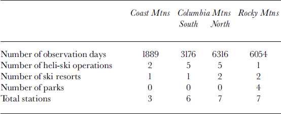
In order to provide sufficiently homogeneous data, we use only the data of stations that fulfil the following three criteria for this analysis: (a) stations with a minimum of 50 observation days per year (i.e. on average at least one observation every 3 days); (b) stations that measured over a minimum time period of 3 years; and (c) stations that are interested in skiing (i.e. ski resorts, heli-ski operations and parks). The resulting study dataset of these 23 stations has more than 17 000 daily entries of stability and weather data.
Since the avalanche hazard is determined not only by daily average weather data, but also by the sequence of specific weather situations, typical weather patterns have been calculated from the daily measurements and were included in the analysis. For this study we assume that the snow stability ratings are correct. It is planned to test this assumption in a follow-up paper by comparing the stability ratings to the natural avalanche events occurring at the same time. The main reason why we have not already integrated the avalanche events is that the size of the observation areas differs greatly between a local ski resort and a helicopter skiing operation. Therefore such an analysis must ensure that the number of observed avalanches does not represent more the size of the observed area than the degree of hazard.
An important point to keep in mind during the analysis is the incompleteness of the data. The size of individual operations as well as temporal environmental conditions, such as bad visibility, prevent the collection of a complete avalanche dataset over such large areas (see also Reference Laternser and SchneebeliLaternser and Schneebeli, 2002; Reference Hägeli and D. M.Hägeli and McClung, 2003).
Study Area Description
Figure 1 gives an overview of the study area, with the operation names of the stations and the four regions, Coast Mountains, North and South Columbia Mountains and Rocky Mountains.Reference McClung and SchaererMcClung and Schaerer (1993) described the snow climate of the Coast Mountains as “maritime”, of the Columbia Mountains as “transitional” and of the Rocky Mountains as “continental”. This classification was not based on extensive study, so it is interesting to see whether the present dataset confirms this snow climate classification. Reference LaChapelleLaChapelle (1966) was the first to establish a definition for weather and avalanche characteristics for different zones in North America: The maritime climate is characterized by frequent new-snow instabilities, which stabilize rapidly due to generally warm temperatures. Rain is possible anytime during the winter, often leading to widespread avalanche cycles. On the other side, the continental snow climate of the Rocky Mountains is characterized by relatively low snowfall and cold temperatures, leading to a shallow snow cover that is often unstable due to structural weaknesses. The transitional zone lies between these extremes and is characterized by a mix of both influences. A more detailed review of the classification terms is included in Reference Hägeli and D. M.Hägeli and McClung (2003).
Map of the study area, with locations of the observation stations and mountain ranges. Coast Mountains: 1. Whistler Mountain; 2. Last Frontier Heliskiing; 3 .TLH Heliskiing. North Columbia Mountains: 4. Cat Powder Skiing Resort; 5. CMH Adamants; 6. CMH Cariboos; 7. CMH Gothics; 8. CMH Monashees; 9. Glacier National; 10. MikeWiegle Helicopter Skiing. South Columbia Mountains: 11. CMH Bobby Burns; 12. CMH Bugaboos Park; 13. CMH Galena;14. Panorama MountainVillage;15. Selkirk Wilderness Skiing; 16. Whitewater Ski Resort. Rocky Mountains:17. Fernie Alpine Resort; 18. Island Lake Lodge; 19. Jasper National Park; 20. Marmot Basin Ski Lifts; 21. Peter Lougheed Provincial Park/Kananaskis Country; 22. Skiing Louise; 23. Sunshine Village.

In the InfoEx database, the transitional zone is further divided along the Rogers Pass into the South and North Columbia Mountains, although the Selkirks and Monashees mountain ranges cross this boundary. This raises the question whether the dataset indicates that this is just an“artificially” introduced administrative region of separation or whether it really has a distinctly different snow and avalanche climate.
Figure 1 reveals that the distribution and coverage of the stations is relatively dense in the Rocky Mountains and even better in the Columbia Mountains, while the coverage of the vast area of the Coast Mountains is very sparse. Table 1 shows that the operations in the Rocky Mountains are most often local ski resorts, with a relatively small observation range, and parks, where forecasting is mainly done for a few high-usage areas. In the Columbia Mountains, heli-ski operations with large-area observation possibilities are predominant. These differences have to be kept in mind when interpreting the measured data. Since only three stations are available in the Coast Mountains that fulfil the requirements to be included in this study, they cannot be considered representative for the whole Coast Mountains range. Among these three stations, the Whistler Mountain station is predominant, since it measured during 11 seasons while the other two heli-skiing operations measured only during 3 seasons. In addition, the Last Frontier heli-ski operation is much further north than the other two stations. To reflect the sparse information within the Coast Mountains, we will use in the following the term “three stations in the Coast Mountains” instead of the global term “Coast Mountains”. In the next section we present the stability ratings of the area and emphasize some notable findings that we discuss in the subsequent weather section.
Observation days and station types in the four main regions
Stability Ratings
In the InfoEx data exchange, the stability is coded as very poor (code 1), poor (3), fair (5), good (7) and very good (9). The stability of the undisturbed snowpack in the operation is assessed. Definitions of the different stability ratings include characteristics of observed or expected avalanche activity with respect to the different triggers (CAA, 2002). This classification scheme has been in use since 1995 and aims to predict the probability that an avalanche will not release. Before 1995, the Canadian hazard-level system with the steps “low”, “moderate”, “considerable”, “high” and “very high”was in use (Reference McClung and TweedyMcClung and Schaerer, 1993, p. 257).
Although not officially sanctioned, the steps between two official classes are also used by many InfoEx contributors, i.e. poor to very poor (code 2), fair to poor (4), good to fair (6) and very good to good (8).
The first three rows inTable 2 show the average of all the stability ratings for every region and elevation class. In all elevation classes the three stations of the Coast Mountains show the highest stability rating, followed by the South Columbia Mountains and, almost with the same ratings, the North Columbia Mountains and Rocky Mountains. The difference between the ALP and BTL stability rating is higher the more continental the location of the mountains.
Stability values for the four regions in western Canada (December – April)

Rows four to six in Table 2 show the percentages of all observations with a stability rating equal to or less than “poor”, and the last three rows the average number of days required for a return to a stability rating “fair”after the stability dropped to “poor”. The recovery time from“poor” to “fair” was calculated using the stability ratings of consecutive observation days. An observation gap of 1 day was tolerated. If the gap was longer, the calculation of the recovery time was halted (e.g. 2 February 1999: poor; 4 February 1999: poor; 5 February 1999: fair equals 3 days of recovery, whereas 2 February 1999: poor; 4 February 1999: poor; 8 February 1999: fair also equals only 3 days of recovery, assuming that with a gap of more than one observation day the rating could have improved to “fair” on the first day of the gap). Note that with this calculation rule, the recovery times are likely to be underestimated.
The rating “poor” occurs less often in the three stations of the Coast Mountains than in the continental mountains. In agreement with the statement of Reference LaChapelleLaChapelle (1966), recovery from a“poor” situation in the three stations of the Coast Mountains is faster than in the other ranges. The North Columbia Mountains show the highest number of “poor” days and also need the longest time to recover from poor to fair.
The average development of the stability ratings over the season is shown in Figure 2. Within the three stations of the Coast Mountains, December is the month with the lowest stability, with an improvement of the stability in January, while in the North Columbia and Rocky Mountains January is as bad as or even worse than December. In the South Columbia Mountains, the stability rating rapidly improves in March, whereas this increase can be seen only in April in the other regions.
Stability development over the season in western Canada.
Weather Data
In this section we present the weather data in order to try to explain the differences in stability ratings presented in the previous section. Table 3 shows some of the most relevant parameters that influence the avalanche activity (Reference McClung and SchaererMcClung and Tweedy, 1993, Reference McClung and Tweedy1994). Due to the more continental climate, but also because of the increase in elevation, the overall temperatures as well as the temperatures during precipitation are lower in the Rocky Mountains than in the three stations of the Coast Mountains and the Columbia Mountains. The wind speed is one of the major differences between the South and North Columbia Mountains. Although a comparison of wind-speed values within each region shows that wind speed is strongly dependent on elevation, the South Columbia Mountains, with an average station elevation of 100 m above the average of the North Columbia Mountains, have a lower wind-speed average. Despite belonging to the same mountain range and having a higher elevation, the South Columbia Mountains have a snow depth on average about 25% smaller than in the northern part.
Average weather data values for the four regions in western Canada

Reference LaChapelleLaChapelle (1966) stated that precipitation in the maritime climate should be much higher than in the transitional and continental climates. Such a large difference cannot be seen between the average snow depth at the three stations in the Coast Mountains and that in the other regions. However, due to the relatively warm temperatures in the Coast Mountains, the snow depths strongly depend on the altitude. The average snow depth of Whistler Mountain is 212 cm at 1890 ma.s.l., whereas the base stations of the two other helicopter operations are at lower altitudes and therefore experience more rain that reduces their snow depth. Comparing the snow depth of the Whistler Mountain station to the average snow depth of the Rocky Mountains which is located at about the same altitude confirms the statement of Reference LaChapelleLaChapelle (1966). Another factor is the proximity to the coast. One station that has not been considered in the statistics, because observations are not performed regularly, is the railway safety program of CN Skeena on the central coast of British Columbia. This station has indeed a very high precipitation (snow depth average: 232 cm) at 1040 ma.s.l.
In order to have a measure for the intensity of large snowfall events, precipitation cycles have been computed for every station. In the InfoEx database, the precipitation is indicated by a variable named precipitation type (Rain/Snow) and intensity (mmh–1 or cm h–1). If this variable indicates precipitation or, in case of a missing value, if the snow depth increases from one day to the next, the day is counted as a precipitation day. Consecutive precipitation days belong to the same precipitation cycle until the next precipitation-free day occurs. Table 3 provides information on the total number of precipitation cycles and the number of precipitation cycles that led to a snow-cover increase of 10 and 30 cm, respectively, and the average duration of such a cycle. In the three stations of the Coast Mountains, the duration of a precipitation cycle of 430 cm increase of snow depth is obviously lower than in the more continental areas and therefore is a clear measure that the snowfall intensity is usually higher in a maritime climate. Nevertheless, in these intense snowfall periods the recovery time from “poor” to “fair” is lower than in the other regions (see Table 2). On the long-term perspective, these homogeneous, thick snow layers formed by intensive snowfall periods contribute to the overall higher snow stability in the maritime Coast Mountains. The snowfall intensity is another factor that differentiates the South from the North Columbia Mountains.
The consideration of precipitation cycles is a first attempt to reflect the sequence of weather patterns in addition to the averaged daily measurements. In the following section, the observed weak-layer data of the study stations are analyzed in order to learn more about how they may contribute to the stability ratings.
Persistent-Weak-Layer Data
Reference Hägeli and D. M.Hägeli and McClung (2003) have extensively analyzed the persistent-weak-layer data of the Canadian Mountain Holiday Heliski operations.They found that one persistent weak layer is usually formed in the early season, and one to three additional weak layers develop during the season. The InfoEx database provides information about weak layers and thus enables a comparison of the weak-layer pattern between the regions. In this study we do not discuss the effect of single weak layers on the avalanche activity, but we continue to compare the number of weak layers that were observed by the different InfoEx subscribers. In the database, there is no distinction between persistent and non-persistent weak layers. We considered weak layers as persistent when they are referred to more than 10 days after creation. Weak layers that were only referred to within the first 10 days were not included in the analysis. In order to avoid non-representative weak layers, only layers were selected that were mentioned three or more times. In Table 4 the number of all reported persistent weak layers over all the years is shown. Note that the weak layers are relatively numerous, since often one specific weak layer (12 November 1999) is also mentioned sometimes as (13 November 1999) or (11November1999) and therefore is counted several times in this statistic. However, it is not the aim of this study to establish a precise count of how many weak layers exist on average per year, but to show trends between the different regions. The most important result of this weak-layer overview is that in the Rocky Mountains less persistent weak layers exist, although the stability rating in the Rocky Mountains shows the lowest values. The question is, what causes this lack of persistent weak layers and what else is responsible for the generally more unstable conditions in comparison to the Coast and South Columbia Mountains?
Weak-layer statistic of western Canada and indicator values for the development of surface hoar and faceted crust layers

Reference Hägeli and D. M.Hägeli and McClung (2003) state that the most important types of persistent weak layers in the Columbia Mountains are surface-hoar and faceted-crystals layers. One prerequisite for the creation of surface hoar is periods of clear weather without daily temperatures above 0°C, so that the surface hoar formed during the night does not melt away during the day. In order to try to extract some of these elements from the weather database, a “clear-night–cold-day” (CNCD) indicator was calculated using the following conditions: the difference between the maximum and minimum temperature has to be more than 5°C, the maximum temperature has to be below 0°C and no wind speed above 25 kmh–1 is allowed in order not to destroy the surface hoar by the mechanical impact of the wind. Based on this parameter, a surface-hoar indicator was calculated. If three CNCDs, which need not be consecutive, are followed by a precipitation without an intermediate temperature increase above 0°C and with wind speeds below 25 kmh–1, the situation is assumed to have potential for a surface-hoar layer.
However, other favourable prerequisites for the building of surface-hoar layers are not covered by the proposed surface-hoar indicator. One of the most serious surface-hoar formations occurs when a temperature inversion due to valley fog occurs. In such situations, the moisture source of the valley fog leads to ideal conditions for the formation of surface hoar right at the top of the fog layer, where the radiative cooling is largest. If the weather station is below the inversion layer, the proposed indicator would not recognize the high potential for surface-hoar development at the inversion boundary. Therefore, the present surface-hoar indicator generally underestimates the occurrence of surface-hoar layers.
Reference Jamieson, Geldsetzer and StethemJamieson and others (2001) relate the creation of a facet-crust layer to a significant rain event, resulting in awet snow layer. If this wet snow is subsequently covered by dry snow and accompanied by a temperature drop, the temperature gradient is high enough to build the faceted crystals in the dry snow layer. In order to estimate the potential for faceted crust development, the number of rain days during December–February was used.
In Table 4, the results of the surface-hoar indicator and the average number of rain days are shown. The high number of CNCD cycles shows that in the Rocky Mountains clear nights exist, but the sky seldom remains clear for an extended period of 3 days or more. The surface-hoar indicator is lower in the Rocky Mountains than in the other regions. On the other hand, the low temperatures reduce the probability of rain that could initiate a persistent facet-crust weak layer. In the North Columbia Mountains, the probability of rain as well as of conditions that favour the creation of surface hoar is higher. All these factors help to explain why in the Rocky Mountains fewer persistent weak layers were reported, but they do not explain why the snow cover is nevertheless assessed as more unstable than in the other regions. Further research is necessary to answer this question. In the following we state two hypotheses that may help to initiate more detailed investigations of this matter:
(1) The numerous lakes in the Columbia Mountains (see Fig. 1) are a significant moisture source that often leads to the formation of valley fog under high-pressure conditions. As mentioned above, this situation is very favourable for surface-hoar formation. The air in the Rocky Mountains is generally much drier and the area does not have a comparable moisture source. This might inhibit the formation of serious surface-hoar layers.
(2) The generally small amount of snow and the cold temperatures in the Rocky Mountains lead to faceting throughout the entire snowpack. This leads to a generally weak snowpack with a poor foundation for the entire season, where forecasters do not (or cannot) necessarily point to individual weak layers.
It should also be kept in mind that in the Rocky Mountains, parks and local ski resorts with groomed tracks predominate (see Table 1), and their focus may be slightly different than that of the heli-ski companies in the Columbia Mountains.
Conclusion and Outlook
The InfoEx database confirms the already well-established classification scheme between the maritime Coast Mountains and the continental Rocky Mountains, and most of its characteristics. The three stations located in the Coast Mountains indicate that the maritime climate is characterized by high temperatures and intensive snowfalls. Although the snowfalls are intense, the recovery time is faster than in the other regions, and the homogeneous snow layers of such large snowstorms contribute to build a higher overall stability.
The Rocky Mountains are characterized by low temperatures, relatively high wind speeds and a generally weak snowpack, which is indicated by a lower average stability rating than in other regions. Further investigations are necessary in order to find out what exactly is causing this generally higher instability if not the persistent weak layers. We stated two hypotheses that may be a starting point for future investigations.
The analysis confirms the separation of the North and South Columbias in the InfoEx database. This is not in agreement with the description of Reference LaChapelleLaChapelle (1966), who described the transitional climate of the Columbia Mountains as a mixture of continental and maritime characteristics. The South Columbia Mountains have higher stability, lower wind speeds and a higher snowfall intensity. In spring the stability rating increases much earlier than in the other regions.
The North Columbia Mountains and the Rocky Mountains have the most unstable conditions. However, the reasons for these instabilities are not the same. Persistent weak layers and rainy days occur in the North Columbia Mountains but are not relevant in the Rocky Mountains. Relatively large snowfall amounts at a low intensity are another main characteristic of this transitional zone.
The integration of not only the average weather data but also the weather sequence pattern provided useful results.
The surface-hoar indicator may help to explain the lack of persistent weak layers in the Rocky Mountains, but it failed to sufficiently reproduce the exact dates of the reported persistent surface-hoar weak layers. One problem of the present surface-hoar indicator is that it does not recognize surface hoar that is formed at the inversion layer boundary.
Further research to establish an indicator for facet-crust layer is necessary to improve understanding of the link between the weather patterns that lead to weak layers. Most of the time the InfoEx does not start early enough to cover the development of this type of weak layer in the Columbia Mountains (see Reference Hägeli and D. M.Hägeli and McClung, 2003).
As mentioned in the introduction, the stability rating itself should be evaluated using natural avalanche events. Future research may also integrate the avalanche involvements in order to search for typical weather/stability patterns, which can lead to avalanche involvements.
Acknowledgements
We would like to thank the CAA for the opportunity to use this extraordinary database for research purposes. Z. Simon and C. Donofrio worked many weeks to correct minor deviations of the standard InfoEx text files so that the files could be parsed automatically. Many thanks also to K. Birkeland whose comments during the review of the paper helped to identify and clarify the limits of a data comparison over such a large area.


