
1.1 Introduction
‘The contemporary face of southern Africa owes much to events in the Cenozoic’ (Partridge and Maud, Reference Partridge, Maud, Partridge and Maud2000a, p3). Thus began the last significant book on the topic of Quaternary environmental change in the subcontinent, sixteen years ago. Although this assessment is still broadly true, advances in the fields of palaeoecology and geochronometry in particular have yielded a far more complex pattern of landscape development in southern Africa during the Cenozoic (66 Ma–present), and more widely from the late Cretaceous onwards. Recent research also highlights a degree of spatial and temporal complexity in patterns of climate and environmental change across southern Africa, and the proxies in which such records have been preserved, that has not been previously recognised (Meadows, Reference Meadows2014). This is especially the case for the Quaternary epoch (last 2.58 Ma; Gibbard and Cohen, Reference Gibbard and Cohen2008). These terrestrial records can also be supplemented by data from marine cores (e.g. n-alkanes, δ18O and 13C records); outputs from the advanced capabilities of climate and land-surface models; and real-time evaluation and modelling of climate and land surface variables on a scale and at a resolution that previously has not been available, based on satellite remote sensing datasets. In addition, there have been significant new palaeo-anthropological finds and modes of data analysis since 2000 that have informed on patterns of human evolution (Beaumont and Vogel, Reference Beaumont and Vogel2006). All of these represent significant advances from Partridge and Maud’s (Reference Partridge and Maud2000b) volume that have increased the power and complexity of Cenozoic datasets. The contemporary topography, climate and environments of southern Africa are remarkably diverse (Figs. 1.1, 1.2), and thus it can be anticipated that climatic conditions in the past, and the geomorphological (landscape-shaping) processes associated with them, were equally diverse. Many potential palaeoclimatic records in southern Africa remain unexploited, and research is now suggesting that African records, in particular during the Pleistocene, may record climatic events such as Dansgaard–Oeschger cycles and Heinrich events that were previously considered only to be a feature of northern hemisphere records (Itambi et al., Reference Itambi, von Dobeneck, Mulitza, Bickert and Heslop2009). Such results suggest that southern Africa is well placed to record variations in the strength of Southern Ocean overturn, as well as monsoon strength and position of the intertropical convergence zone (Garcin et al., Reference Garcin, Vincens, Williamson, Buchet and Guiot2007; McGee et al., Reference McGee, Donohoe, Marshall and Ferreira2014). These are some of the emerging areas of palaeoclimatic research in the subcontinent.

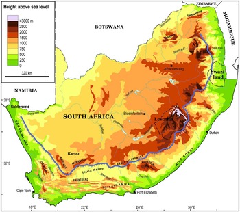
Fig. 1.1. Map of the topography of southern Africa (in m above sea level) and the location of the Great Escarpment (hatched line). Note that other key regional maps are presented elsewhere in this book: regional geology (Fig. 2.1), soils (Fig. 16.2) and ecosystems (Figs. 18.1, 18.2).
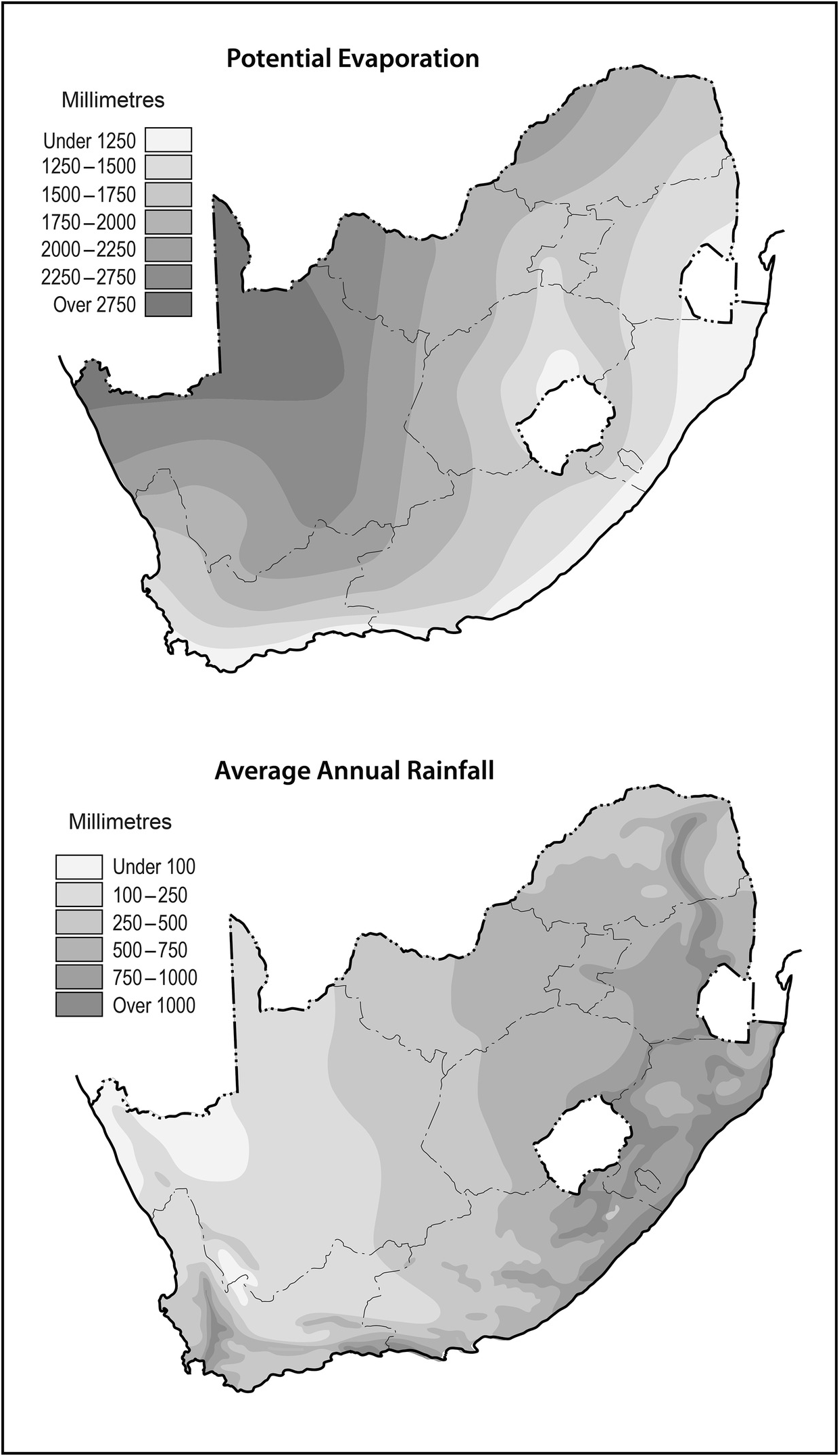
Fig. 1.2. Maps of key climatic features of South Africa, as expressed by potential evaporation (upper panel) and annual average rainfall (lower panel). The contrast between spatial patterns of these parameters shows that northwestern South Africa has a large moisture deficit, which has strongly impacted on geomorphological processes and landforms, ecosystems and the capacity for varied human activities in the region, including agriculture.
It can also be said that the ‘contemporary face’ of southern Africa has changed much since 2000. The impacts of human activity on all parts of the southern African landscape (Binns, Reference Binns1997), on its geomorphological processes, and on its varied resources (including biodiversity and ecosystem services; soils, agriculture and food security; water security and water quality; waste management) are now recognised as significant issues, not just for environmentalism and landscape conservation and management, but more significantly as a major limitation to achieving sustainable socioeconomic development in the 21st Century (Cole et al., Reference Cole, Bailey and New2014; Ziervogel et al., Reference Ziervogel, New, Archer van Garderen, Midgley, Taylor, Hamann, Stuart-Hill, Myers and Warburton2014). Climate assessment reports published by the Intergovernmental Panel on Climate Change (IPCC) also highlight the vulnerability of sub-Saharan Africa to anthropogenic climate change (global warming), and that climate change over coming decades may result in significant, wide-ranging and yet poorly understood impacts on both physical and human environments (Niang et al., Reference Niang, Ruppel, Abdrabo, Essel, Lennard, Padgham, Urquhart, Barros, Field, Dokken, Mastrandrea, Mach, Bilir, Chatterjee, Ebi, Estrada, Genova, Girma, Kissel, Levy, MacCracken, Mastrandrea and White2014).
It is in this wider context that this book is set: there is no more important time than now for developing a better understanding of the Quaternary context of landscape–human relationships in southern Africa. As scientists, we look to the past in both geologic, faunal and cultural records to help inform on the processes and sensitivities of the landscape and its contemporary peoples to future change, and this uniformitarian principle can help us when evaluating the challenges facing southern Africa, its landscapes and peoples, over coming decades (Ziervogel et al., Reference Ziervogel, New, Archer van Garderen, Midgley, Taylor, Hamann, Stuart-Hill, Myers and Warburton2014). This chapter considers the wider context of Quaternary environmental change in southern Africa and the nuanced and complex narratives now beginning to emerge from recent inter- and multidisciplinary research into landscape–human relationships. In detail, this chapter (1) discusses the geologic and geomorphic framework whereby such environmental resources are provided; (2) presents models of evolution of the southern African landscape during the Cenozoic, and in particular the Quaternary, that shaped today’s landscape; and (3) considers the range of environmental resources offered by the southern African landscape that were (are) of relevance to past (present) patterns of human activity.
1.2 The geologic and geomorphic context of southern Africa
The geological history of southern Africa is exceptionally long, extending from 3600 million years ago to present, and covering a wide range of depositional and tectonic settings (McCarthy and Rubidge, Reference McCarthy and Rubidge2005; Hunter et al., Reference Hunter, Johnson, Anhaeusser, Thomas, Johnson, Anhaeusser and Thomas2006). A timeline of critical geological and human evolutionary events over different timescales is given in Figure 1.3. Tectonic processes (continental accretion and rifting, epeirogenic uplift), magmatic processes (intrusion and extrusion of igneous rocks, metamorphism and mineralisation), sedimentary processes (basin formation and infilling), and climate change (land surface weathering and erosion) have been the major regional-scale controls on southern Africa’s geological history and resulting rock types. The relationship between underlying geology, topography, geomorphology and climate is complex, and has been examined in several studies (e.g. Bishop, Reference Bishop2007; Partridge et al., Reference Partridge, Dollar, Moolman and Dollar2010).
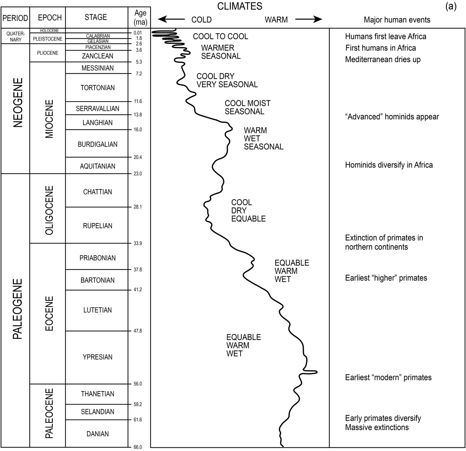
(a) Simplified timeline of the Cenozoic (66 Ma to present), showing the major climatic and human events to have affected southern Africa (adapted from Partridge et al., Reference Partridge, Bond, Hartnady, deMenocal, Ruddiman, Vrba, Denton, Partridge and Burckle1995; geologic timescale from the Geological Society of America; www.geosociety.org/science/timescale/). Note that there is uncertainty on the timing and/or magnitude of climatic and human events.

(b) Simplified timeline from the Middle Pleistocene (~460 kyr) to present; showing the δ18O record from SE Atlantic core MD962094 (Stuut et al., Reference Stuut, Prins, Schneider, Weltje, Jansen and Postma2002); and elemental Fe counts from SE Atlantic core ODP1083 (West et al., Reference West, Jansen and Stuub2004), with the major human events over this timescale in southern Africa. LSA: Late Stone Age, MSA: Middle Stone Age.

(c) Simplified timeline for the period 25 kyr to present, showing δ18O values from Makapansgat (Limpopo Province, South Africa) speleothem record (Holmgren et al., Reference Holmgren, Lee-Thorp, Cooper, Lundblad, Partridge, Scott, Sithaldeen, Talma and Tyson2003), where LIA: Little Ice Age, YD/H0: Younger Dryas/Heinrich event 0, H1: Heinrich event 1, H2: Heinrich event 2; principal component analysis scores for moisture variations from three sites (the continuous and dashed lines) at Braamhoek wetland (Free State, South Africa) (Scott et al., Reference Scott, Neumann, Brook, Bousman, Norström and Metwally2012), and major human events over this timescale in southern Africa. LSA: Late Stone Age, MSA: Middle Stone Age.
Cosmogenic dating of exposed and buried rock surfaces can inform on rates of land surface denudation and sediment accumulation, respectively (Decker et al., Reference Decker, Niedermann and de Wit2011). Dating studies from different physical environments and locations across southern Africa show different rates of land surface change that vary according to rock type, climate zone and tectonic setting (Portenga and Bierman, Reference Portenga and Bierman2011), and mesoscale properties such as slope angle, and location relative to hilltops or river valleys (Bierman and Caffee, Reference Bierman and Caffee2001). The lowest rates of land surface change are found on exposed but isolated summits of mesas, koppies and bornhardts (Bierman and Caffee, Reference Bierman and Caffee2001), which are preserved largely because of high rock strength and low drainage density (Moon, Reference Moon1990). Chadwick et al. (Reference Chadwick, Roering, Heinsath, Levick, Asner and Khomo2013) demonstrated that landscape-scale weathering and erosion in river catchments of the Kruger National Park (northeastern South Africa) contribute to low but spatially consistent denudation rates of 3–6 m/myr, which are similar to those calculated by independent geochronometric methods. These authors argued that river drainage density and slope gradients within river catchments show a consistent relationship with precipitation, such that climate is the most important control on landscape evolution, rather than geology alone, and that long-term weathering and erosion contributes to downslope sediment supply and sediment yield to river basins, but that this is modified by local geology (Decker et al., Reference Decker, Niedermann and de Wit2013). There is a self-limiting relationship between weathering and erosion processes and the evolution of land surface topography. For example, over many footslope locations across southern Africa, an extensive colluvial mantle has developed (Watson et al., Reference Watson, Price-Williams and Goudie1984), which attests to climatically driven denudation and slope instability from at least the mid-Pleistocene onwards (Dardis, Reference Dardis1990). Valley infilling and decreased slope angle through colluviation reduces slope instability and thus the rate of land surface change. Such a situation, often recorded by large cosmogenic exposure or burial ages (thus low denudation rates), does not reflect land surface stability at all, but rather low accommodation space in upland source areas. Cosmogenic dating, although critical for evaluating land surface evolution in southern Africa, has limited applicability where not all physical environments have been dated, or are capable of being dated, and where interpretation of cosmogenic dates is based on limited understanding of their geomorphological and sedimentary context.
However, this viewpoint of ‘climatically controlled geomorphology’ is but one approach. Other studies have argued that spatial and temporal patterns of land surface denudation in southern Africa can be explained by tectonic processes. For example, based on modelling, thermochronometric and cosmogenic dating evidence, episodes of tectonic uplift from the late Cretaceous onwards are followed by episodes of accelerated rates of land surface denudation (e.g. Braun et al., Reference Braun, Guillocheau, Robin, Baby and Jelsma2014). However, there are relatively large errors associated with the use of such evidence to calculate denudation rates, and many land surface feedbacks through the accumulation of weathering mantles, ecosystem and carbon cycle responses, and river system responses, are difficult to evaluate (de Wit, Reference de Wit2007).
1.3 Climate and environmental changes in southern Africa prior to the Quaternary
Climate and environmental changes of the late Cenozoic (Neogene; 23.0–2.6 Ma) in southern Africa are set within the wider context of ongoing tectonic evolution, speciation and ecosystem changes, and hominin evolution during this time period (Partridge et al., Reference Partridge, Bond, Hartnady, deMenocal, Ruddiman, Vrba, Denton, Partridge and Burckle1995). These linked changes are often difficult to distinguish in terms of cause and effect, within dating resolution, hence the causal relationships between these components are often still unclear or contentious in many cases (Lavier et al., Reference Lavier, Steckler and Brigaud2001; de Wit, Reference de Wit2007; Jung et al., Reference Jung, Prange and Schulz2014). This poses an interpretive challenge with respect to identifying the relative roles of tectonics or climate in macroscale land surface evolution. For example, Cenozoic and pre-Cenozoic volcanism in southern Africa, associated with emplacement of the Karoo and Etendeka igneous provinces, led to considerable topographic land surface changes (Partridge et al., Reference Partridge, Bond, Hartnady, deMenocal, Ruddiman, Vrba, Denton, Partridge and Burckle1995; Phillips et al., Reference Phillips, Kiniets, Biddulph, Madav, Partridge and Maud2000). In turn, this resulted in enhanced subsequent land surface weathering and erosion, and river water and geochemical export into surrounding oceans, affecting water chemistry, biotic processes, and hemispheric climate feedbacks (e.g. Roelandt et al., Reference Roelandt, Godderis, Bonnet and Sondag2011).
Most evidence for Neogene environments and climates comes from isolated onshore and offshore depocentres where mineral and organic sediments have accumulated and been preserved (Fig. 1.4). Marine cores in the South Atlantic show palynological and sedimentary evidence for changes in zonal climate and atmosphere–ocean circulation patterns. For example, a drying trend in the Middle Miocene is marked by increased aeolian contribution to ocean sediments from the developing Namib Desert (Senut et al., Reference Senut, Pickford and Ségalen2009; Roters and Henrich, Reference Roters and Henrich2010), and land surface aridity in southwest Africa (Pickford et al., Reference Pickford, Senut, Mocke, Mourer-Chauviré, Rage and Mein2014). This period (around 14–11 Ma) matches with continental glaciation of Antarctica, the spread of cold Antarctic Deep Water, invigorated Benguela Current upwelling, and zonal atmospheric circulation (Jung et al., Reference Jung, Prange and Schulz2014). In the late Miocene and Pliocene, changes in Polar Front position over the Southern Ocean influenced rainfall seasonality in Namibia, including moisture source (Dupont et al., Reference Dupont, Rommerskirchen, Mollenhauer and Schefuß2013). Increased winter rainfall and resulting Renosterveld vegetation displaced xerophytic savannah in Namibia as the Polar Front migrated northwards, increasing cold water advection and thus rainfall into the region (Dupont, Reference Dupont2006). This also had an impact on the distribution of C3/C4 flora (Franz-Odendaal et al., Reference Franz-Odendaal, Lee-Thorp and Chinsamy2002; Ségalen et al., Reference Ségalen, Renard, Lee-Thorp, Emmanuel, Le Callonnec, de Rafélis, Senut, Pickford and Melice2006) and on mammalian fossil assemblages found at key human evolution sites such as Swartkrans (Avery, Reference Avery2001). Periods of aridity during the Miocene are marked by the development of silcrete and calcrete weathering profiles found on the African Surfaces, discussed later (Blumel and Eitel, Reference Blumel and Eitel1994; Marker et al., 2002).

Fig. 1.4. Environmental changes during the late Cenozoic, with a particular focus on southern Africa. (a) Global sea level changes relative to present (Haq et al., Reference Haq, Hardenbol and Vail1987); (b) key regional climatic events (from various sources named in the text); (c) relative sediment accumulation rates at South Atlantic ODP sites 1088 and 1092 (Diekmann et al., Reference Diekmann, Fälker and Kuhn2003). H = hiatuses; (d) variations in marine accumulation rates (MAR) for calcium carbonate (calc) and terrigeneous (terr) debris (grey line), ODP1085A, offshore Orange River, South Atlantic
1.4 Models of landscape evolution in southern Africa
Cosmogenic dating has invigorated debate on land surface evolution models. These are of particular interest in southern Africa through the ground-breaking work of du Toit (Reference du Toit1954) and King (Reference King1963). Initially, du Toit (Reference du Toit1954, pp. 573–575) invoked Davisian ideas of cyclic episodes of landscape evolution, comprising Tertiary and Quaternary tectonic uplift and/or sea-level change around coastal fringes, followed by formation of peneplains at different levels, which were later incised. Later, King (Reference King1963, pp. 49–55) expanded on these ideas and discussed a ‘landscape cycle’ of pediplanation for the evolution of the southern African landscape. This ‘pediplanation’ involved a period of river incision followed by one of parallel scarp retreat. Using the Davisian evolutionary stages of youth, maturity and old age, King argued that the youth stage is dominated by river incision, and as this stage progresses, stream density decreases as rivers become larger. The maturity stage is dominated by scarp retreat as river valleys widen and flat land surfaces, inherited from the youth stage, reduce in size. In the old-age stage, opposing scarps meet each other and the resulting ridges gradually decrease in height, forming a low-relief landscape. King mentions some specific examples of these evolutionary stages from southern Africa, arguing that these stages can coexist in different areas.
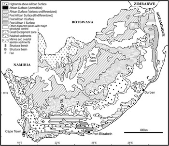
The persistence of flat-lying surfaces in the landscape, equivalent to King’s ‘pediplains’, has been long noted (Partridge and Maud, Reference Partridge and Maud1987, their Appendix A; Partridge, Reference Partridge1998). In broad age-order, these are the African Surface (Cretaceous age), Post-African I (mid-Tertiary), and Post-African II (late Tertiary) Surfaces (Fig. 1.5). Preserved remnants of earlier and later surfaces have also been identified. These surfaces have been used as important markers in the landscape evolution story of southern Africa, but the notion of time-equivalent and accordant surfaces is inherently problematic and involves substantial circular reasoning based on untestable hypotheses. For example, all accordant surfaces of the same altitude are argued to be of the same age and thus affected by the same spatially uniform tectonic regime. Surfaces located at different altitudes must therefore be of different ages or affected by different tectonic regimes. Surfaces are assumed to be of a single ‘age’ that represents a Davisian-style peneplain that is at equilibrium. The extent of land surface incision has also been used as an indicator of relative age (Partridge and Maud, Reference Partridge and Maud1987, Reference Partridge, Maud, Partridge and Maud2000a). There are also implications for understanding the landscape context of hominin evolution, which is necessary in order to correctly evaluate the environmental controls on this evolution (Dirks and Berger, Reference Dirks and Berger2013).

Fig. 1.5. Map of South Africa showing assumed and geochronometrically dated land surface ages, and assumed correlatives. The African Surface ages are identified largely on lithostratigraphic principles
Two lines of evidence now clearly show that such ideas of macroscale land surfaces are untenable. (1) Cosmogenic dates from equivalent land surfaces, discussed earlier, show highly variable ages (in the range 105–106 years) and thus variable resulting rates of land surface denudation. They show that land surfaces are not passive relicts but are actively being dissected and denuded with high spatial and temporal variability (Fleming et al., Reference Fleming, Summerfield, Stone, Fifield and Cresswell1999; Tinker et al., Reference Tinker, de Wit and Brown2008; Moore et al., Reference Moore, Blenkinsop and Cotterill2009; Erlanger et al., Reference Erlanger, Granger and Gibbon2012). The notion of landscape palimpsests, now commonly discussed in areas undergoing differential areal denudation (e.g. Stroeven et al., Reference Stroeven, Fabel, Hättestrand and Harbor2002), provides a geomorphological interpretive framework for these ‘non-surfaces’. (2) Some recent studies using different radiometric dating methods, including apatite fission track thermochronology of igneous rocks that are now exposed on the surface, show that very substantial land surface uplift, and thus denudation, has taken place since rock formation. For example, Tinker et al., (Reference Tinker, de Wit and Brown2008) showed that around 1 km thickness of rock from the Cape Fold Belt has been eroded since the late Cretaceous. This is highly inconsistent with the static equilibrium and preservation of isochronous surfaces. The view presented by Partridge and Maud (Reference Partridge, Maud, Partridge and Maud2000a) on the macroscale landscape evolution of southern Africa is therefore very dated and reflects a Davisian-style approach to landscape dynamics. New digital satellite datasets of the land surface, including spectral reflectance, altimetry and gravity, also enable a better understanding of spatial and temporal variations of the land surface and its attributes.
1.5 South African landscapes and environmental resources
The environmental resources (rocks/minerals, soil, water and ecosystems) provided in varied southern African landscapes have made these landscapes particularly favourable for the development of the Homo species and human activities over long time scales (Vrba et al., Reference Vrba, Denton, Partridge and Burckle1995; Reed, Reference Reed1997). The general environmental settings favourable for human evolution and spread, in particular during the fluctuating climates of the Cenozoic, are well met in southern Africa. The presence of generally flat grasslands (velds) and isolated hilltops (koppies) favoured the movement and occupation of human social groups, respectively, which likely mirrored the evolution and spread of other animal species, and thus facilitated development of the high faunal and floral endemism recorded in many areas. Prominent landscape positions provided by local geomorphology, such as caves and rock shelters, acted as foci for a range of human domestic, territorial and ritual activities. Freshwater resources in the form of rivers and ephemeral lakes (pans) in the dry interior of the region were fundamental to the spread inland and then occupation of the landscape by hominid groups, as well as other species. Rivers and pans not only attracted large animals and thus hunter populations, but also provided fertile areas for food and fibre resources, and facilitated the spread of species along river valleys. Weathering and soil development in footslope locations and where rainfall is sufficient, favoured the development of settled agriculture. More marginal and drier areas favoured hunter-gathering activities, in which populations utilised different faunal and floral resources. Likewise, the availability of specific geological resources such as materials suitable for working, influenced both the locations and impacts of small-scale knapping activities and, later, the large-scale working of areas by mining. In turn, these economic activities strongly influenced hominid/human settlements, trading routes, and the types and spread of different cultural activities, including pottery and metalworking, traditions and beliefs. The coincidence of locations where a range of environmental resources is provided, and known archaeological sites, shows the importance of these resources in influencing the trajectory and manifestation of human evolution (both morphological and behavioural) throughout the Quaternary.
1.6 About this book
This book covers a range of topics concerning the physical and human environments of southern Africa during the Quaternary. Chapters in this book include contributions by 39 authors from 24 institutions in 9 different countries; the Quaternary of southern Africa is therefore of global research concern. In detail, this book is organised into three sections. Section I deals largely with the pre-Quaternary background of southern Africa, including geology, tectonics, climate and long-term hominid evolution. Section II deals with the Quaternary and Holocene environmental and climatic records of different southern African physical environments, and focuses in more depth on human evolution and development in the context of landscape and environmental change. Section III aims to draw together the physical and human dimensions of Quaternary environmental change in southern Africa, discussing the interconnections between the physical and human environments, and identifying the critical research strands for future decades. We argue that both physical and human Quaternary environmental research in southern Africa can profit from a mutual understanding, and that their intersection in the fields of cultural anthropology, behavioural archaeology, landscape archaeology and geoarchaeology, and in geo- and landscape-heritage conservation, is a critical future research area.
Some recent books that include discussion on southern African geomorphology include those by Moon and Dardis (Reference Moon and Dardis1988), Partridge and Maud (Reference Partridge and Maud2000b), Holmes and Meadows (Reference Holmes and Meadows2012), and Grab and Knight (Reference Grab and Knight2015). This volume differs from these previous books in that it explicitly identifies and discusses the relationships between climate and environmental change, geomorphological processes, and human evolution and activities. As such, it represents a significant change in the ways in which the physical and human dimensions of the southern African landscape can be conceptualised and drawn together in a coherent and interdisciplinary way, to address the research needs of the 21st Century, and to apply modern methods to investigate the past.
1.7 Summary
Climatic and tectonic events over the last 66 Ma have impacted the macroscale geomorphology of southern Africa and, in turn, the geomorphological processes operating on the land surface. These processes are important on long time scales, not only for shaping the nature of today’s land surface, but also for providing the environmental context within which human evolution has taken place during the Quaternary. Furthermore, the close interconnections in the southern African landscape between physical (environmental) and human factors can help identify and value cultural landscape resources and geoheritage.