
9.1 Introduction
Large amounts of unconsolidated sediment can accumulate on shallow hillslopes from transport mechanisms as diverse as aeolian and fluvial processes and mass movements. Many authors refer to hillslope deposits as ‘colluvium’, which tends to be defined differently in various contexts around the world (Leopold and Völkel, Reference Leopold and Völkel2007). The term generally refers to locally derived sediments, transported by running water or under the influence of gravity. This distinguishes alluvial sediments which are commonly channel-bound, from the unconfined movement of sheetwash or mass movement deposits (Fuchs and Lang, Reference Fuchs and Lang2009). Stratified colluvial sediments in southern Africa are widely distributed below steep hillslope segments where mass movement processes dominate (Moon, Reference Moon, Moon and Dardis1998). Thick regolith, weathering products or soil profiles are commonly the sources of sediments that are redistributed downslope. Accretion on slopes where the gradient might exceed the angle of repose for sediments of various sizes, textures and shapes renders such deposits inherently unstable and susceptible to redistribution downslope. Landslides occur within regolith or weathered bedrock that is rendered unstable due to settlement, consolidation, high moisture content, seismic vibration or anthropogenic destabilisation. This unsorted debris may then be reworked and transported onto lower slopes by sheetwash and shallow ephemeral channel processes. On lower gradient slopes or in climatic zones where vegetation cover is able to reduce the influences of rainsplash or overland flow, fine-textured colluvial sediments accrete and are subject to pedogenic modification when slope instability declines.
Comprehensive studies of mass movement process and landslide susceptibility modelling have been published at a national scale in South Africa by Singh et al. (Reference Singh, Forbes, Chiliza, Diop, Musekiwa and Claassen2011) and at a regional scale such as for KwaZulu-Natal Province (Singh et al., Reference Singh, Botha, Richards and McCarthy2008; Singh, Reference Singh2013) (Fig. 9.1). The widespread distribution of fine-textured, sandy hillslope deposits, typified by the gully (donga) sidewall exposures of colluvium across KwaZulu-Natal and part of Free State Province have also been described (Botha et al., Reference Botha, Scott, Vogel and von Brunn1992, Reference Botha, Wintle and Vogel1994; Botha, Reference Botha1996; Botha and Partridge, Reference Botha, Partridge, Partridge and Maud2000; Clarke et al., Reference 150Clarke, Vogel, Botha and Wintle2003; Temme et al., Reference Temme, Baartman, Botha, Veldkamp, Jongmans and Wallinga2008). Similar sediments in parts of Swaziland were described by Watson et al. (Reference Watson, Price Williams and Goudie1984) and Dardis (Reference Dardis1989, Reference Dardis1990). Thick wedges of colluvial deposits on lower hillslopes can represent valuable archives for interpreting slope evolution and the effects of cyclical climate change on slope stability (Botha et al., Reference Botha, Wintle and Vogel1994; Botha, Reference Botha1996; Temme et al., Reference Temme, Baartman, Botha, Veldkamp, Jongmans and Wallinga2008).

Fig. 9.1. Landslide susceptibility map for South Africa
This chapter assesses the diverse deposits associated with slope instability in southern Africa. These hillslope sediments are assessed from the perspective of landscape evolution at various timescales, as well as their significance with respect to the palaeoenvironmental conditions that trigger hillslope instability and colluviation, relative to factors that result in stabilisation of the deposits.
9.2 Slope processes in the long-term landscape evolution of southern Africa
Research into the terrain morphology, Cenozoic geology and geomorphological history has contextualised the long-term landscape evolution of the southern Africa region (e.g. Fleming et al., Reference Fleming, Summerfield, Stone, Fifield and Cresswell1999; Partridge and Maud, Reference Partridge and Maud1987, Reference Partridge, Maud, Partridge and Maud2000). Different slope elements are shown in Figure 9.2. Interpretations of landscape evolution in southern Africa have speculated on the existence of ancient land surface remnants (King, Reference King1944) and highlighted the significance of Great Escarpment backwearing by fluvial and slope processes in response to continental uplift over a period of about 140 Ma since the rifting of Gondwana during the early Cretaceous (Partridge and Maud, Reference Partridge and Maud1987, Reference Partridge, Maud, Partridge and Maud2000).
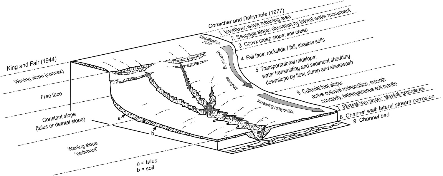
Fig. 9.2. Schematic longitudinal section through a hillslope showing the land surface and slope elements, as defined by King and Fair (Reference King and Fair1944) and Conacher and Dalrymple (Reference Conacher and Dalrymple1977)
These morphotectonic models and patterns of regional epeirogenesis have been tested by quantitative assessments of bedrock denudation chronologies using cosmogenic 36Cl methods on exposed rock surfaces along the Drakensberg sector of the Great Escarpment (Fleming et al., Reference Fleming, Summerfield, Stone, Fifield and Cresswell1999), apatite fission-track analysis (Brown et al., Reference Brown, Gallagher, Gleadow, Summerfield and Summerfield2000, Tinker et al., Reference Tinker, de Wit and Brown2008), cosmogenic 26Al and 10Be isochron burial dating (Erlanger et al., Reference Erlanger, Granger and Gibbon2012), and 26Al and 10Be exposure dating (Bierman et al., Reference Bierman, Coppersmith, Hanson, Neveling, Portenga and Rood2014). The analysis of resistant bedrock formations and alluvial or marine terrace deposits using these techniques has generated a range of averaged denudation rates that are able to contextualise geomorphic activity across the region. Fleming et al. (Reference Fleming, Summerfield, Stone, Fifield and Cresswell1999) calculated a scarp retreat rate of 50–95 m/Ma for sites along the Drakensberg escarpment over a 104–106 year timespan, which is an order of magnitude lower than the mean retreat rate of ~1.0–1.5 km/Ma implied by the Partridge and Maud (Reference Partridge and Maud1987) model of Great Escarpment backwearing since the early Cretaceous. These calculated rates have implications for slope debris production and thus slope stability. Fleming et al. (Reference Fleming, Summerfield, Stone, Fifield and Cresswell1999) compare the rate of thin spalling (49–63 m/Ma) to that of block shedding (83–95 m/Ma) on the Drakensberg escarpment. The low calculated rate of summit lowering, only 6 m/Ma, points to the differential geomorphic impact of instability of steep slopes and areas of high relief, compared to low gradient slopes (ibid.). This is also supported by dating evidence elsewhere along the Great Escarpment (Chadwick et al., Reference Chadwick, Roering, Heimsath, Levick, Asner and Khomo2013).
By comparing terrestrial sediment supply to offshore deposition budgets since ~136 Ma, Tinker et al. (Reference Tinker, de Wit and Brown2008) showed that regional-scale denudation rates decreased by an order of magnitude during the Cenozoic, which may be due to a combination of climate change, tectonic quiescence and greater slope stability at this time. Using 10Be in river sediments, Bierman et al. (Reference Bierman, Coppersmith, Hanson, Neveling, Portenga and Rood2014) found rates of erosion in south-central South Africa of ~5 m/Ma, consistent with other tectonically quiescent areas. These long term landscape process rates refute the hypotheses of large scale, rapid uplift events (Partridge and Maud, Reference Partridge and Maud1987, Reference Partridge, Maud, Partridge and Maud2000) and are consistent with slower rates of Cenozoic exhumation (e.g. Erlanger et al., Reference Erlanger, Granger and Gibbon2012). These long term process rates also assume that bedrock responses are uniform spatially and temporally, although differences in rock mass strength, rock type and structure may also be important controls (Moon and Selby Reference Moon and Selby1983; Moore and Blenkinsop, Reference Moore and Blenkinsop2006). In addition, there are process–form feedbacks that mean that, as slope height, length and angle changes over time in response to headwall erosion, the rate of that erosion decreases (Moon and Munro-Perry, Reference Moon and Munro-Perry1988). Although colluvial deposits related to early land surface remnants are rare, gravels cemented by siliceous and ferruginous duricrusts of Neogene age are preserved on pediment remnants in the Cape Fold Mountain foothills (Bierman et al., Reference Bierman, Coppersmith, Hanson, Neveling, Portenga and Rood2014). In most cases, however, even where the Pleistocene colluvial succession is well constrained by luminescence dating, derivation of short term rates of accretion is hampered by hiatuses.
9.3 Colluvial processes
In many parts of southern Africa, accumulation of slope deposits occurs below the transition from steep, relatively unstable upper hillslopes to the long, low-gradient pediment slopes. Here, thick colluvial wedges may develop below bedrock steps. Over the Pleistocene, global glacial–interglacial climatic changes have influenced the rate of regolith production on upper hillslopes through alternation of periods conductive to weathering, and subsequent failure of regolith through mass movements. The cyclical generation of erodible soil or landslide sediment that is transported to and deposited on mid slopes, and the hillslope environmental conditions that lead to accretion or stripping of pediment cover, is intrinsic to the understanding of spatial and temporal cycles of hillslope activity and stability across the region (Singh et al., Reference Singh, Botha, Richards and McCarthy2008). Thick regolith can be destabilised and transported downslope by different hillslope processes.
9.3.1 Hillslope colluviation
Cyclical development of pediment surfaces during the Pleistocene has led to the accretion of sheetwash deposits, in particular in KwaZulu-Natal. The lack of widespread older colluvial mantles suggests that these sediments accrete episodically and their preservation is temporary over longer geological timescales, as long as uplift and drainage channel rejuvenation continue. These hillslope deposits in KwaZulu-Natal have been assigned as the Masotcheni Formation (Partridge et al., Reference Partridge, Botha, Haddon, Johnson, Anhaeusser and Thomas2006) of broadly Cenozoic age, although the precise age and the spatial and temporal context of Masotcheni Formation-equivalent colluvia elsewhere in southern Africa remain uncertain.
In hilly terrain with marked relief and rock outcrops defining hill crests, the transition zone from convex to concave lower slopes exhibits a smooth landsurface form and subdued microrelief, commonly indicative of thick soil cover. Geomorphic models by King and Fair (Reference King and Fair1944) and Conacher and Dalrymple (Reference Conacher and Dalrymple1977) have characterised this transitional zone as the pediment or transportational midslope/colluvial footslope (Fig. 9.2). Across a broad range of climatic conditions, mainly on the eastern seaboard of southern Africa, erosional landscapes where drainage lines are incising through headcut erosion of rills and gullies (Fig. 9.3), infilled high-order tributary valleys and colluvial hollows have been exposed. These reveal profiles through poorly sorted, thinly bedded colluvial sediment and complex soil profiles that attest to the long-term degradation of this landscape (Dardis, Reference Dardis1989, Reference Dardis1990; Botha et al., Reference Botha, Scott, Vogel and von Brunn1992). Such sediments are nonetheless widespread and in some locations may be stable over timescales of up to 150 kyr. Particularly in the central and western parts of KwaZulu-Natal, hillslopes are often mantled by Masotcheni Formation colluvial sediments that appear to have accreted in pulses rather than gradually (Botha, Reference Botha1996). The main indicators for cyclical accretion and erosion include post-depositional pedogenesis and the existence of erosional hiatuses in the colluvial stratigraphy, represented by infilled palaeogullies and buried palaeosols (Fig. 9.4).

Fig. 9.3. The locations of gully systems in South Africa (adapted after le Roux, Reference le Roux2011). These are mainly cut into the Masotcheni Formation and equivalent colluvia.
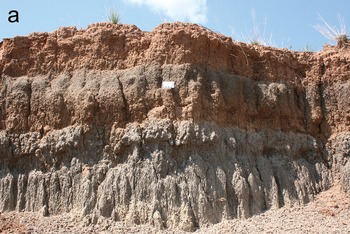
Fig. 9.4. Photos of depositional and erosional elements of gully systems in KwaZulu-Natal. (a) sedimentary succession of slope sediments and buried palaeosols (photo courtesy of Mary Evans), (b) road-cut at Keate’s Drift showing bedrock-cut gullies which have then been infilled by slope sediments (I)
Research on colluvial sediments of the Masotcheni Formation has focussed on their stratigraphic subdivision by means of buried palaeosols and depositional layering, which allows for regional correlation (Botha et al., Reference Botha, Scott, Vogel and von Brunn1992; Botha and Fedoroff, Reference Botha and Fedoroff1995; Botha, Reference Botha1996; Clarke et al., Reference 150Clarke, Vogel, Botha and Wintle2003; Temme et al., Reference Temme, Baartman, Botha, Veldkamp, Jongmans and Wallinga2008, Reference Temme, Schaap, Sonneveld and Botha2012). The palaeoenvironmental context for colluvial events can be informed by regional palaeoclimate records such as the 200-kyr rainfall record from the Pretoria Saltpan (Tswaing) (Partridge et al., Reference Partridge, deMenocal, Lorentz, Paiker and Vogel1997) and pollen/charcoal records from eastern South Africa (Scott, Reference Scott2002). Although the Masotcheni Formation colluvia cover large areas of in particular eastern South Africa, the texture of the colluvial sediments is strongly linked to the weathered bedrock regolith. For example, sandstones and shales weather to medium to fine-grained, moderately sorted sands which may give rise to well-stratified slope deposits and possibly perched water tables. By contrast, sediments derived from weathered granite are coarser, have higher permeability and steeper angles of repose, but may also contain weathered core-stones which thus give rise to a bimodal sediment texture. Depositional laminations may be preserved locally when not obscured by post-depositional pedogenesis. Silt and clay derived from eroded regolith upslope is winnowed and generally transported downslope. At most sites the increase in silt and clay in colluvial sediments is closely related to the degree of soil formation. Sand deposition is influenced by the density of grass vegetation cover or surface roughness in the form of rills and shallow gullies. However, Telfer et al. (Reference Telfer, Mills and Mather2014) interpreted stratified and massive fine sand deposits within hillslope deposits in the eastern Free State mountains as aeolian sediments interbedded with Masotcheni Formation colluvium. Pebble lenses within the sediment stratigraphy commonly represent shallow or ephemeral channel deposits. Colluvium may also contain clasts of reworked soil material or resistant materials like ferricrete pisoliths, which may accumulate as lags. Gravel lags sometimes contain stone tool artefacts, suggesting residual concentration of large clasts on the land surface. The relatively low energy sheetwash transport mechanism is illustrated by the intact burial of large ‘knapping floor’ middens from the Middle Stone Age (Botha, Reference Botha1996).
9.3.2 Distribution of colluvium in southern Africa
Watson et al. (Reference Watson, Price Williams and Goudie1984) regarded colluvium as mantling about 20% of the land surface of Africa south of the Zambezi, representing one of the most widespread geomorphic deposits on the subcontinent. Indeed, these slope deposits have been described from the Mpumalanga Lowveld through Swaziland and the drainage basins of central KwaZulu-Natal to the Eastern Cape. At higher elevations, hillslope deposits occur in the Drakensberg foothills and extend through the eastern Free State and are widespread in the Maluti mountain foothills of Lesotho (Botha, Reference Botha1996). These deposits have a more restricted distribution in the semi-arid parts of the northern provinces of South Africa, Zimbabwe and Botswana (Watson et al., Reference Watson, Price Williams and Goudie1984). The characteristics and distribution of colluvial deposits that are commonly exposed by preferential gully erosion have been reviewed by Botha (Reference Botha1996) and Botha and Partridge (Reference Botha, Partridge, Partridge and Maud2000). Coarse mass movement debris and crudely stratified boulder deposits are common on steep slopes in the Cape Fold Mountains (Partridge and Botha, Reference Partridge, Maud, Partridge and Maud2000). The rolling hills of the Swartland region of the Western Cape Province also exhibit gullying of regolith (Boardman et al., Reference Boardman, Hoffman, Holmes, Wiggs, Holmes and Meadows2012).
The lithological structural control on hillslope morphology defined by alternating sandstone/shale beds or the effect of resistant dolerite sills and shale beds or the influence of lithological steps in river gradients can influence the thickness and distribution of colluvial sediment mantles on adjacent hillslopes. Landscape-scale complexity, often modulated by rivers but affecting entire catchments, can influence the rate of colluviation and erosion independently of vegetation cover change or precipitation characteristics. Knickpoints on streams or slope breaks can reduce erosive forces or the headcutting retreat rate of gullies, thereby reducing colluviation and promoting pedogenesis on the land surface (Temme et al., Reference Temme, Baartman, Botha, Veldkamp, Jongmans and Wallinga2008, Reference Temme, Schaap, Sonneveld and Botha2012).
9.3.3 Dating of colluviation
In order to interpret the environmental and climatic controls on land surface stability, dating control on sediment layers or buried palaeosols is needed. Prior to the availability of radiocarbon dating, researchers interpreted hillslope erosion and colluviation events on the basis of the incorporated Early or Middle Stone Age artefacts, which lacked chronological bracketing (e.g. Davies, Reference Davies1950), or with reference to the sequence of late Pleistocene global climatic cycles. Stone Age artefact assemblages and carbonate nodules were used to define the Bovu and Mphunga Colluvium units in the lower Middelveld of Swaziland, from which accumulation of the Mphunga sediment after ~40 kyr BP was inferred (Price Williams et al., Reference Price Williams, Watson and Goudie1982; Watson et al., Reference Watson, Price Williams and Goudie1984). Radiocarbon dating of colluvial sequences is often limited by the absence of deposited organic matter such as charcoal. Secondary soil carbonates or organics often represent post-depositional pedogenic modification, which means that the radiocarbon ages determined are a weighted mean of the longer period of formation (Botha, Reference Botha1996). Subsequently, radiocarbon and luminescence dating can be deployed singly or in combination for age-control of palaeosols and colluvial deposits (e.g. Botha et al., Reference Botha, Scott, Vogel and von Brunn1992; Wintle et al., Reference Wintle, Li and Botha1993, Reference Wintle, Li, Botha and Vogel1994; Botha, Reference Botha1996; Telfer et al., Reference Telfer, Thomas and Breman2012; Lyons et al., Reference Lyons, Tooth and Duller2013).
A comprehensive chronological framework spanning over 135 kyr of Masotcheni Formation colluvial accretion on hillslopes in KwaZulu-Natal and the eastern Free State was based on radiocarbon and luminescence dates reported by Wintle et al. (Reference Wintle, Botha, Li and Vogel1995) and Botha (Reference Botha1996). Multiple accretion phases of the Voordrag palaeosol succession over more than 100 kyr was defined by bracketing radiocarbon-dated palaeosols (Botha et al., Reference Botha, Scott, Vogel and von Brunn1992) with luminescence dates on the intervening colluvial sediments (Clarke et al., Reference 150Clarke, Vogel, Botha and Wintle2003). Colluvium and palaeosols in the Okhombe valley of the Drakensberg foothills were dated using the luminescence method by Temme et al. (Reference Temme, Baartman, Botha, Veldkamp, Jongmans and Wallinga2008), indicating eleven phases of colluvial accretion since ~42 kyr. In the higher elevation valleys of the Golden Gate area, Telfer et al. (Reference Telfer, Thomas and Breman2012) used the luminescence method to date slope sediment accretion during the period 47–16 kyr BP. Fuchs and Lang (Reference Fuchs and Lang2009) reviewed the use of luminescence dating of colluvium where inadequate duration, intensity and spectral composition of light exposure during transport can result in poorly bleached sediment, resulting in age over-estimation. Unfortunately, colluvial successions seldom contain materials that can be used to provide reliable independent chronological assessments against which the luminescence ages can be assessed.
9.4 Palaeoenvironmental interpretation of colluvial and slope deposits
Age estimates suggest that Pleistocene colluvium often accumulated during arid stages, while pedogenesis may have occurred under periods of relative stability influenced by greater humidity and vegetation cover. The conceptual model underpinning this suggestion was that of Knox (Reference Knox1972), that predicts a peak in redistribution (and hence colluviation) during transitions from dry to wet conditions, when precipitation has increased but whilst vegetation has not yet recolonised slopes. Temperature was not generally found to be a significant driving factor for colluviation (Clarke et al., Reference 150Clarke, Vogel, Botha and Wintle2003), although Temme et al. (Reference Temme, Baartman, Botha, Veldkamp, Jongmans and Wallinga2008) suggest that low temperatures may have been a factor controlling the occurrence of solifluction-derived colluvium at the base of steep slopes at higher elevations, close to the Drakensberg escarpment, where cold-air drainage played a role. During the same period (after ~43.1±0.5 kyr BP), Grab and Mills (Reference Grab and Mills2011) report pulses of colluvial sediment deposition associated with solifluction in the high Drakensberg plateau region. Correlation of phases of colluviation and pedogenesis between different locations in KwaZulu-Natal has been attempted by Botha (Reference Botha1996). This has to some extent been successful, and has led to the definition of allostratigraphic units that can be used to correlate colluvial strata between sites; and pedoderms, that can correlate palaeosols formed in the colluvium.
Luminescence dating of the deposits within Sibudu rock shelter in KwaZulu-Natal by Jacobs et al. (Reference Jacobs, Wintle, Duller, Roberts and Wadley2008) identified three periods of occupation during the Middle Stone Age. These were associated with distinct cultural phases centred on 58.5, 47.7 and 38.6 kyr BP. Occupational hiatuses around 10.8±1.3 and 9.1±3.6 kyr BP, during Marine Isotope Stage (MIS) 3, were interpreted as representing dry periods when environmental conditions impacted human activities in the area. These periods coincide with colluvial deposition events on hillslopes in the interior of KwaZulu-Natal, bracketed by periods of hillslope stability associated with palaeosol development, that have been widely described from the Masotcheni Formation colluvial deposits (Botha, Reference Botha1996, Reference Botha, Partridge and Maud2000; Botha and Partridge, Reference Botha, Partridge, Partridge and Maud2000; Clarke et al., Reference 150Clarke, Vogel, Botha and Wintle2003). Periods of regional slope instability and soil erosion on hillslopes during MIS 4 and 3 were probably associated with altered rainfall patterns, environmental cooling and desiccation, and reduced vegetation cover. Evidence of significant change in vegetation structure and composition during this time has been revealed in pollen assemblages of wetland palaeosols exposed in the Voordrag donga within the Mkhuze River valley, northern KwaZulu-Natal (Botha et al., Reference Botha, Scott, Vogel and von Brunn1992; Clarke et al., Reference 150Clarke, Vogel, Botha and Wintle2003).
The relationship between colluvial slope deposits and floodplain alluvium indicates the changing balance between valley sides and fluvial channel activity in the interior of southeastern Africa. The steep-sided Mkhomazi River valley (KwaZulu-Natal) exposes thick colluvial deposits which buried two generations of alluvial terraces, represented by rapid/pool sedimentation and oxbow channel infill deposits. Accretion of sheetwash sediments over terrace alluvium at ~38 kyr BP, and gradual burial of floodplain palaeosols that formed prior to ~43 kyr BP, suggests that the gravelly colluvium derived from fissile shale exposed on the valley slopes accreted during the period preceding the coldest, driest phase of the last glacial period in this region.
Telfer et al. (Reference Telfer, Thomas and Breman2012) interpreted the sand accreted on slopes below Clarens Formation sandstone exposed in the Golden Gate area (Free State Province) as sand ramps comprising aeolian sand blown from the high altitude valleys during MIS 3/2 in the late Pleistocene. Studies over a broader area reported by Telfer et al. (Reference Telfer, Mills and Mather2014) correlated the gully eroded hillslope deposits with the Masotcheni Formation of KwaZulu-Natal, and noted the inclusion of aeolian sand beds not recorded in occurrences elsewhere.
9.4.1 Present-day dynamics: land surface degradation
Since the early 20th Century, widespread erosion has been observed into colluvium across southern Africa (e.g. Botha, Reference Botha1996). This problem has been linked to grazing pressure as well as cultivation of soils susceptible to erosion (Boardman et al., Reference Boardman, Hoffman, Holmes, Wiggs, Holmes and Meadows2012; Mighall et al., Reference Mighall, Foster, Rowntree and Boardman2012). This erosion causes losses in agricultural productivity and soil water retention capacity (Temme et al., Reference Temme, Schaap, Sonneveld and Botha2012), more difficult access to fields (Sonneveld et al., Reference Sonneveld, Everson and Veldkamp2005), siltation of downstream water courses, and damage to buildings and infrastructure. Based on pollen and charcoal preserved within recent sediments at Compassberg, Eastern Cape, Mighall et al. (Reference Mighall, Foster, Rowntree and Boardman2012) suggested that soil erosion was enhanced by agricultural practices since the 1930s. The onset of gullying within thick colluvial deposits at St Paul’s (KwaZulu-Natal) is indicated by a surficial layer of laminated sand that buries a soil horizon dated at 1290±30 cal yr BP (Pta-4837) (Wintle et al., Reference Wintle, Li and Botha1993), suggesting that gully incision has occurred within the past 1500 years. Gully sites at the Blood River vlei (KwaZulu-Natal) indicate final hillslope sedimentation at ~0.29 kyr BP for one site, with deposition of sandy sediment forming fans below incised gullies from ~0.89 kyr BP (Lyons et al., Reference Lyons, Tooth and Duller2013). The timing of these indicators of hillslope instability was correlated with the Medieval Warm Period (~AD 900–1300) and Little Ice Age (~AD 1300–1800).
Past erosion phases are also evidenced in the colluvial stratigraphy (Botha et al., Reference Botha, Wintle and Vogel1994), which raises the question as to what extent current erosion is a natural process influenced by climate changes (Lyons et al., Reference Lyons, Tooth and Duller2013), or whether it is caused by human (land use) pressures. This debate fits within a wider discussion in southern Africa and elsewhere about the social context of erosion (e.g. Meadows, Reference Meadows2003; Boardman et al., Reference Boardman, Hoffman, Holmes, Wiggs, Holmes and Meadows2012), yet remains largely unresolved. In the colluvium of the Okhombe valley (KwaZulu-Natal), Sonneveld et al. (Reference Sonneveld, Everson and Veldkamp2005) focussed on this issue, concluding that increasing population pressure, expressed as the number of homesteads within the catchment, did not coincide with an increasing amount of erosion features over the period AD 1945–2000, although abandonment of fields did seem to cause an increase in erosion. In addition, extensive colluvial mantles up to 13 m thick in the high Drakensberg are entirely a product of climate-driven geomorphic processes, without human influences (Grab and Mills, Reference Grab and Mills2011). Supporting natural driving factors, Rienks et al. (Reference Rienks, Botha and Hughes2000) found that the erodibility of Masotcheni Formation sediments elsewhere in KwaZulu-Natal was correlated with soil electrical conductivity and sodium adsorption ratio values, and that landscape position and geomorphic threshold conditions also co-determine erosion. Whereas initial gully incision processes are often related to surficial soil chemistry, the catastrophic evacuation of bedrock depressions infilled with colluvium is related to the inherent erodibility of these sandy sediments, influenced partly by the chemical characteristics of buried palaeosols.
Many colluvial sequences in KwaZulu-Natal contain strata with varying textures, including layers with low hydraulic permeability. Consequently, in many cases there is considerable interflow which, combined with the high erodibility of sediments (Rienks et al., Reference Rienks, Botha and Hughes2000), leads to a prevalence of subsurface erosion though tunnels or soil pipes (Beckedahl, Reference Beckedahl1998) (Fig. 9.5). Soil pipes often grow in size until their roofs collapse and a gully system is suddenly visible on the surface. It is currently unknown to what extent soil pipes have functioned as precursors of the extensive gully systems in colluvial deposits, and to what extent they continue to do so.

Fig. 9.5. A soil pipe and its collapse into a gully system
The absence of detailed regional mapping of colluvial deposits across the landscape hinders the interpretation of regional gully erosion maps such as those produced by le Roux et al. (Reference le Roux, Newby and Sumner2007, Reference le Roux, Morgenthal, Malherbe, Pretorius and Sumner2008). The majority of gullies are associated with thick colluvial/palaeosol deposits, but deep weathering profiles in high rainfall areas are also susceptible to gullying. The obvious disruption of dryland agriculture, sedimentation of river channels and increased turbidity of runoff water entering rivers, are widely acknowledged erosional aspects of colluvium.
9.5 Summary
Colluvium deposition in footslope locations is well marked across southern Africa. Studies of colluvial stratigraphy and dating of buried palaeosols have been undertaken in particular in KwaZulu-Natal where relatively steep slopes and weathering of sandstones and basalts of the Great Escarpment region have given rise to a complex interplay between fluvial action, slope processes and land-use change. Episodes of colluvium deposition generally correspond to cool Pleistocene climate phases, but incision and gullying of colluvial slopes is not so clearly linked to climate forcing, and may reflect a combination of climatic, geological and anthropogenic factors. These are as yet poorly understood, and colluvial deposits generally represent an under-exploited palaeoenvironmental archive in southern Africa.


