




Introduction
The Late Bronze Age in the Eastern Mediterranean concluded with the demise of numerous long-lived administrative states, accompanied by attendant reconfigurations of settlement scale and structure in many regions. Such changes, dated to approximately 1200 BC, have long been framed as an instance of societal collapse (Cline Reference Cline2021). This picture, however, is far from uniform (Maran Reference Maran and Driessen2016; Knodell Reference Knodell2021). The Bays of East Attica Regional Survey (BEARS) project, focused on surface remains in and around the bay of Porto Rafti, Greece, reveals the socioeconomic characteristics of one coastal community that thrived in the Aegean region post-collapse.
Around 1200 BC, a new community settled in Porto Rafti Bay, located on the eastern Attic coast. The bay is protected from coastal currents by the headlands and islands at its mouth and provides an excellent natural anchorage (Figure 1). Notwithstanding these advantages, there is no evidence for human presence in Porto Rafti between c. 2200 and 1200 BC, when a large, wealthy cemetery was established at Perati on its north coast. This remained in use for some 150 years (Iakovidis Reference Iakovidis1980). Perati's burials are unusually rich within their regional and chronological context, containing fine pottery, jewellery made from precious metals, ivory and semi-precious stones, bronze and iron weapons and tools, and imported artefacts from Cyprus, the Syro-Palestinian coast and Egypt (Iakovidis Reference Iakovidis1980; Murray Reference Murray2018). Such finds raise questions regarding the locations of associated settlement and sources of the community's apparent prosperity.
Map and location of Porto Rafti Bay (map by S. Murray).

Results of the BEARS project: Raftis and Praso Islands
The BEARS project seeks answers to these questions based on the surface assemblages of Porto Rafti. Operating under the authority of the Canadian Institute in Greece, with the permission of the Ephorate of Antiquities of East Attica, the project has conducted three seasons of intensive surface survey since 2019. The methods and a description of finds from the 2019 season were published in a preliminary report (Murray et al. Reference Murray2020). Here, we present a summary and first interpretation of evidence from the post-palatial period on Raftis and Praso Islands, documentation of which was completed in 2021 and 2022 (Figure 2).
Raftis, Praso and Raftopoula Islands (photograph by S. Murray).

On Raftis, a widespread and dense scatter of Late Helladic IIIC (1200–1050 BC) artefacts, including pottery, groundstone objects, figurines, lithics and many other categories of small find, constitutes secure evidence for a large site. The full repertoire of pottery expected in a settlement context for this period is present in abundance, from industrial vats and coarseware pithoi to decorated finewares, miniatures and ritual vessels. The range of cooking vessels, including griddles, trays and tripods in many fabrics and types (Figure 3), is extraordinary, since contemporaneous twelfth century sites are usually characterised by simple cooking wares. The Raftis material more closely resembles complex cooking sets associated with elite contexts of the previous, palatial period (Murray et al. Reference Murray2020: 373).
Cooking vessels from Raftis (photographs by S. Murray).

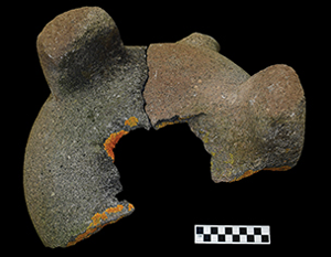
Other finds indicate that the island was used for craft production. We interpret the presence of several hundred groundstone objects, including at least ten specimens of an otherwise rare type of tripod mortar (Figure 4) and several pieces of un-worked or semi-worked non-native volcanic raw materials, as evidence that grinding, hammering and pounding tools were being manufactured on Raftis. Possible evidence for metal processing is present in the form of sherds from metallurgical ceramics.
Tripod mortar fragments from Raftis (photographs by S. Murray).

Survey on Praso Island yielded additional evidence for industry, especially waste products from ceramic production. Most numerous are wasters in a distinctive fabric known as White Ware (Figure 5). White Ware circulated widely throughout the Aegean in the twelfth and early eleventh centuries and has been identified at numerous sites ranging from south-central Greece to the western Anatolian coast (Figure 6). Analytical study indicates that all White Ware probably came from a single production centre (Lis et al. Reference Lis, Mommsen and Sterba2023). The evidence from Praso strongly suggests that this production centre was in east Attica.
A White Ware waster from Praso (photograph by S. Murray).

Sites where certain or probable White Ware exports have been identified (map by S. Murray and B. Lis).

In contrast to these two sites, survey around the bay did not reveal concentrations of LH IIIC pottery, apart from a scatter on Raftopoula, another island. The evidence thus indicates that Porto Rafti was settled by a sea-oriented community that invested specifically in the bay's islands, stayed in the area for only a few generations, and engaged in a range of craft activities, including the manufacture of ceramic, groundstone and metal objects.
The maritime focus of the community is highlighted by two aspects related to craft production. On one hand, the metal and groundstone industries must have relied on inputs of non-local raw materials. On the other hand, pottery manufactured locally was distributed outward through regional and supra-regional maritime trade networks.
Conclusions
Together with previously documented mortuary evidence from Perati, data from the BEARS project provide the basis for reconstructing an entrepreneurial post-collapse community engaged in multiple types of industrial production and exploiting islands during the closing phases of the Bronze Age. What factors might explain the prosperity of this community? The choice of offshore islands as a base was surely important, as they offered additional security during volatile times. Yet it seems that, for Porto Rafti's inhabitants, the islands also offered another advantage: immediate proximity to maritime routes (Kramer-Hajos Reference Kramer-Hajos2016: 174–78). These stretched north to the Euboean Gulf, east through the Cyclades to western Anatolia and Cyprus, and south towards the Peloponnese, as the distribution of White Ware indicates (see Figure 6). Here, we would like to suggest that the crucial factor in this community's success may have been its possession of wide-ranging practical knowledge related to both the crafts practiced in Porto Rafti and an ability to distribute the resulting products through maritime networks.
An important point to emphasise is that the area was apparently uninhabited for a thousand years prior to 1200 BC, meaning that this knowledge was brought to Porto Rafti by newly arrived people. Although it is difficult to reconstruct their origin with certainty, a palatial-type setting including non-local craftsmen—best exemplified by finds from Tiryns (Murray Reference Murray2018: 56–57)—appears to offer a plausible scenario. Connections to palatial material culture are apparent, for example, in the cooking wares on Raftis (see Figure 3). A possible Cypriot presence, including craftsmen, has been postulated based on characteristics of the Perati finds (Murray Reference Murray2018). Cypriots were also known as capable tradesmen, who were already involved in the circulation of Mycenaean pottery in the palatial period (Sherratt Reference Sherratt and Moreno García2016: 293–96). If they were indeed present in this area, it is tempting to see their entrepreneurial spirit behind the distribution of White Ware, which recalls expansive palatial-period trade networks, rather than more circumscribed post-palatial ones. These are some of the hypotheses that the project will investigate as material enters further stages of analysis.
Funding statement
Fieldwork was funded by the University of Toronto Connaught Fund, the Social Sciences and Humanities Research Council of Canada, the Loeb Classical Library Foundation and the Institute for Aegean Prehistory. Study of the LH IIIC pottery was funded by the Polish National Science Centre (grant no. 2016/21/D/HS3/02696).


 Open access

