


Introduction
For decades, the Middle Palaeolithic of Central Asia has been treated as peripheral to more widely studied regions, such as the Near East, Africa and Europe. Central Asian stone tool assemblages have been analysed and named according to well-established European typologies and nomenclature (Ranov Reference Ranov1995; Davis & Ranov Reference Davis and Ranov1999), although researchers have long pointed out the issues surrounding the archaeological specificity of such schemes (e.g. Otte & Derevianko Reference Otte and Derevianko1996; Vishnyatsky Reference Vishnyatsky, Brantingham, Kuhn and Kerry2004; Otte Reference Otte2017, Reference Otte2021). This is highlighted by sites such as Obi-Rakhmat, in the western Tian Shan piedmonts, which displays the development of early blade technology dating back to c. 80–70 ka BP (Derevianko et al. Reference Derevianko2001; Krivoshapkin et al. Reference Krivoshapkin, Anoikin and Brantingham2007).
This situation, however, has changed recently, primarily due to genetic analyses of human remains from Denisova Cave (Reich et al. Reference Reich2010). Within the last 10 years, intensive, multidisciplinary research in the Altai region and Central Asia has become a focal point for discussing human interactions during the Middle–Upper Palaeolithic transition (Derevianko Reference Derevianko2015, Reference Derevianko2017; Mafessoni et al. Reference Mafessoni2020). As a result, at least four independent human populations can be identified in Central Asia during this period based solely on ancient DNA (Kolobova et al. Reference Kolobova2020). New fieldwork aimed at understanding the archaeological context for this genetic variability is crucial to current debate (Krivoshapkin et al. Reference Krivoshapkin, Anoikin and Brantingham2007; for further discussion, see Zwyns Reference Zwyns2021). Here, we present the most recent study of Palaeolithic settlement in the western Tian Shan mountains.
The Kuksaray 2 Palaeolithic site
In the last nine years, over 20 open-air Palaeolithic sites have been identified in the Chatkal Range, Ahangaran Valley (Figure 1) (Krajcarz et al. Reference Krajcarz2016). In 2021, fieldwork focused on locating stratified deposits via test-trenching at surface sites that had been previously discovered using predictive modelling (Leloch et al. Reference Leloch2022). Consequently, several new open-air sites were identified (Figure 2A). The largest is Kuksaray 2, which covers an area of over 20ha. It is located at the confluence of the Kuksaray and Dziblon gorges, on the terrace of the Ahangaran Valley (Figure 2B). A total of 455 lithic artefacts were found (412 surface finds and 43 artefacts from stratified contexts) (Figure 3), although recent construction of high-voltage electricity lines has partially destroyed the site.
Location of Kuksaray 2 and other Palaeolithic sites found in the region since 2013 (prepared by M. Kot using StepMap).

A) View of Kuksaray 2 and other Palaeolithic sites along the Ahangaran Valley; B) view of the site from Kuksaray Valley. ES = Ertash Sai; KK = Kuksaray (photograph by M. Kot).

A) Surface findspots and test-trench locations; B) heatmap of artefact concentrations across the surface (drawn by M. Leloch).

Test-trenches were first opened on the south-west slope of the hill where the highest concentration of surface artefacts was located (Figure 3); however, these uncovered up to 0.5m of thin, diluvial sediments without artefacts, overlying the limestone bedrock. The original loess cover, measuring at least 3.5m in thickness—test trenches did not reach the bedrock—was identified in the northern part of the site (Figure 4). Three test-trenches opened along the northern ridge of the hill revealed a complex loess stratigraphy, with 43 stone artefacts recovered from at least four sedimentological units (Figure 4). OSL dating indicates an unexpectedly early age of c. 89.8 ka BP and c. 70.4–77.5 ka BP for the two lowest archaeological horizons, respectively (Figures 4 & 5; for OSL dating methods, see Moska et al. Reference Moska2021). Whether the artefacts found within the uppermost horizons are of late MIS 3 and MIS 2 age, or result from post-depositional movement of the earlier horizons, has yet to be determined. At least some of them bear Middle Palaeolithic/Initial Upper Palaeolithic traits (Figure 6, no. 4) and there are notable analogies to other recently studied assemblages, such as Katta Sai 2 (Pavlenok et al. Reference Pavlenok2021).
OSL dating of the strata, and stratigraphic correlation between test-trenches (drawn by M. Kot).

Graphs of the age distribution for all investigated OSL samples, together with specific activities of natural radionuclides, dose rate, estimated water content, number of measured aliquots, final equivalent dose (CAM or MAM model) and calculated age (drawn by P. Moska and M. Kot).

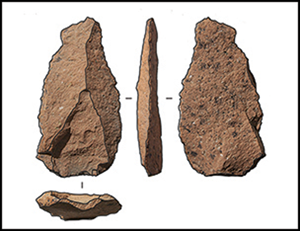
Lithic artefacts from Kuksaray 2: 1–3 & 5–7) are from surface collection; 4) artefact found in layer 2B1. 1) Levallois core; 2) truncated faceted tool with burin spalls on both sides; 3) convergent double-sided scraper; 4) blade; 5–6) Levallois points; 7) burin (photographs by S. Kogai, illustrations by N. Vivlina and M. Kot).

The surface-collected and stratified artefacts are made of flint and effusive rocks. The high number of cores (n = 54; 11.8%) might indicate a workshop, but further study is required to test this hypothesis. Cores present included Levallois (Figure 6, no. 1), blade, and burin cores (Figure 6, no. 2). Middle Palaeolithic tool types, such as truncated-faceted tools, side scrapers and high double-side scrapers (Figure 6, no. 3), and Upper Palaeolithic tool types, including end scrapers and burins, were also present.
Discussion and future research
Future research will determine whether the assemblages found in the two lowest horizons (layers 3B and 5) display Middle Palaeolithic or Initial Upper Palaeolithic features. Even at this preliminary research stage, we can observe a surprising similarity to the Obi-Rakhmat assemblage both in terms of chronology and toolkit, including the presence of burin cores, truncated-faceted tools, burins and convergent side scrapers. On the other hand, Levallois cores, blades and points (Figure 6, nos 5–6) were not as abundant at Obi-Rakhmat but do prevail at other Middle and Initial Upper Palaeolithic sites in the region—namely Katta Sai 1 and 2 (Pavlenok et al. Reference Pavlenok2021; Kot et al. Reference Kot2022).
The results show that Palaeolithic occupation in the mountain environment of the Tian Shan piedmonts was not ephemeral and can be dated not only to MIS 3 but also to MIS 4, or even late MIS 5. Kuksaray 2, therefore, may be a key site for understanding the technological and cultural shifts between MIS 5 and MIS 3 in this region. Of importance is the early appearance of Initial Upper Palaeolithic traits in the region (c. 70 ka BP at Obi-Rakhmat; Krivoshapkin et al. Reference Krivoshapkin, Anoikin and Brantingham2007) and their relationship to Middle Palaeolithic assemblages with Levallois technology, which are, in contrast, dated to relatively late (40 ka BP at Katta Sai 1; Pavlenok et al. Reference Pavlenok2021).
Funding statement
This study was supported equally by the National Science Centre, Poland (grant nos 2017/25/B/HS3/00520) and the Russian Foundation for Basic Research (project 20-09-00440а).


 Open access