Refine search
Actions for selected content:
95781 results in Archaeology
CHRONOLOGICAL STUDY OF COLLECTIVE BURIALS IN THE NORTHERN IBERIAN PLATEAU: ANALYSIS OF RADIOCARBON DATES ON HUMAN BONES FROM THE MEGALITHIC COMPLEX OF LA LORA (BURGOS, SPAIN)
-
- Journal:
- Radiocarbon / Volume 66 / Issue 1 / February 2024
- Published online by Cambridge University Press:
- 11 March 2024, pp. 155-204
- Print publication:
- February 2024
-
- Article
-
- You have access
- Open access
- HTML
- Export citation
RETREATMENT OF BONE MATERIAL IN THE GLIWICE RADIOCARBON LABORATORY USING ULTRAFILTRATION
-
- Journal:
- Radiocarbon / Volume 66 / Issue 1 / February 2024
- Published online by Cambridge University Press:
- 19 March 2024, pp. 134-146
- Print publication:
- February 2024
-
- Article
- Export citation
RADIOCARBON DATING OF ST. GEORGE’S ROTUNDA IN NITRIANSKA BLATNICA (SLOVAKIA): AN ARCHAEOLOGICAL COMMENT
-
- Journal:
- Radiocarbon / Volume 66 / Issue 1 / February 2024
- Published online by Cambridge University Press:
- 19 March 2024, pp. 147-154
- Print publication:
- February 2024
-
- Article
-
- You have access
- Open access
- HTML
- Export citation
HORIZONTAL WATERMILL CHRONOLOGIES BASED ON 14C DATING OF ORGANICS IN MORTARS: A CASE STUDY FROM JARASH, JORDAN
-
- Journal:
- Radiocarbon / Volume 66 / Issue 1 / February 2024
- Published online by Cambridge University Press:
- 11 March 2024, pp. 205-248
- Print publication:
- February 2024
-
- Article
-
- You have access
- Open access
- HTML
- Export citation
RDC volume 66 issue 1 Cover and Front matter
-
- Journal:
- Radiocarbon / Volume 66 / Issue 1 / February 2024
- Published online by Cambridge University Press:
- 11 April 2024, pp. f1-f3
- Print publication:
- February 2024
-
- Article
-
- You have access
- Export citation
When the Foreign Becomes Familiar: The Glass Bead Assemblage from Madjedbebe, Northern Australia
-
- Journal:
- Cambridge Archaeological Journal / Volume 34 / Issue 3 / August 2024
- Published online by Cambridge University Press:
- 01 February 2024, pp. 421-438
-
- Article
-
- You have access
- Open access
- HTML
- Export citation
SPATIOTEMPORAL PATTERNS ON THE APPEARANCE OF THE FIRST TRAPEZE INDUSTRIES IN THE LATE MESOLITHIC OF THE IBERIAN PENINSULA
-
- Journal:
- Radiocarbon / Volume 66 / Issue 1 / February 2024
- Published online by Cambridge University Press:
- 14 February 2024, pp. 59-100
- Print publication:
- February 2024
-
- Article
-
- You have access
- Open access
- HTML
- Export citation
New Book Chronicle
-
- Article
-
- You have access
- HTML
- Export citation
AQY volume 98 issue 397 Cover and Back matter
-
- Article
-
- You have access
- Export citation
Yeghegis-1 rockshelter site: new investigations into the late Chalcolithic of Armenia
-
- Article
-
- You have access
- Open access
- HTML
- Export citation
AQY volume 98 issue 397 Cover and Front matter
-
- Article
-
- You have access
- Export citation
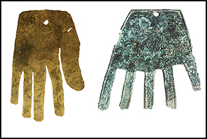
A Vasconic inscription on a bronze hand: writing and rituality in the Iron Age Irulegi settlement in the Ebro Valley
-
- Article
-
- You have access
- Open access
- HTML
- Export citation
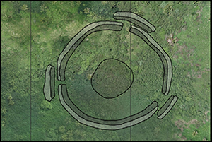
Early architecture in Tonga: implications for the development of Polynesian chiefdoms
-
- Article
-
- You have access
- Open access
- HTML
- Export citation
NEW PERSPECTIVES ON OLD MATTERS: A REVIEW OF ARCHAEOLOGICAL AND CHRONOMETRIC DATA FROM ABRIGO DO SOL (MATO GROSSO, BRAZIL)
-
- Journal:
- Radiocarbon / Volume 66 / Issue 1 / February 2024
- Published online by Cambridge University Press:
- 04 April 2024, pp. 46-58
- Print publication:
- February 2024
-
- Article
-
- You have access
- Open access
- HTML
- Export citation
GEOCHRONOLOGY OF PHREATOPHYTIC MOUNDS ON THE ATMUR EL KIBIESH, EGYPT: WITH DESCRIPTIONS OF PLANTS COLLECTED DURING THE EXPEDITION TO THE EASTERN SAHARA, EGYPT, AND SUDAN (APPENDIX I)
-
- Journal:
- Radiocarbon / Volume 66 / Issue 1 / February 2024
- Published online by Cambridge University Press:
- 13 February 2024, pp. 101-117
- Print publication:
- February 2024
-
- Article
-
- You have access
- Open access
- HTML
- Export citation
EVALUATING THE TIMING OF EARLY VILLAGE DEVELOPMENT IN NEW YORK: MORE DATES FROM CLASSIC NEW YORK SITES
-
- Journal:
- Radiocarbon / Volume 66 / Issue 1 / February 2024
- Published online by Cambridge University Press:
- 27 February 2024, pp. 18-45
- Print publication:
- February 2024
-
- Article
-
- You have access
- Open access
- HTML
- Export citation
RECONSTRUCTING THE CHRONOLOGY OF BUILDING THE SOUTHWEST CHURCH OF UMM EL-JIMAL, JORDAN BY AMS RADIOCARBON DATING OF MORTAR AND PLASTER
-
- Journal:
- Radiocarbon / Volume 66 / Issue 1 / February 2024
- Published online by Cambridge University Press:
- 27 February 2024, pp. 1-17
- Print publication:
- February 2024
-
- Article
- Export citation

Beyond the bluestones: links between distant monuments in Late Neolithic Britain and Ireland
-
- Article
-
- You have access
- Open access
- HTML
- Export citation
Implications of the geochemistry of L1LL1 (MIS2) loess in Poland for paleoenvironment and new normalizing values for loess-focused multi-elemental analyses
-
- Journal:
- Quaternary Research / Volume 120 / July 2024
- Published online by Cambridge University Press:
- 31 January 2024, pp. 18-35
-
- Article
-
- You have access
- Open access
- HTML
- Export citation
