Refine search
Actions for selected content:
95778 results in Archaeology
A Possible Case of Coccidioides Infection in a Thirteenth-Century Bolivian Mummy
-
- Journal:
- Latin American Antiquity / Volume 35 / Issue 3 / September 2024
- Published online by Cambridge University Press:
- 17 August 2023, pp. 629-636
- Print publication:
- September 2024
-
- Article
-
- You have access
- Open access
- HTML
- Export citation
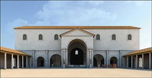
Living with the gods in the Roman Empire: “Everything, everywhere, all at once” - J. Rüpke, and G. Woolf, eds. 2021. Religion in the Roman Empire. Die Religionen der Menschheit 16. Stuttgart: Kohlhammer Verlag. Pp. 323. ISBN: 978-3-170-29224-6.
-
- Journal:
- Journal of Roman Archaeology / Volume 36 / Issue 2 / December 2023
- Published online by Cambridge University Press:
- 17 August 2023, pp. 539-545
- Print publication:
- December 2023
-
- Article
- Export citation
THE THOMAS ASHBY PHOTOGRAPHIC ARCHIVE: A PRIVATE ARCHIVE NOW IN THE PUBLIC DOMAIN
-
- Journal:
- Papers of the British School at Rome / Volume 91 / October 2023
- Published online by Cambridge University Press:
- 17 August 2023, pp. 273-306
- Print publication:
- October 2023
-
- Article
- Export citation

Animals hidden in plain sight: stereoscopic recording of Palaeolithic rock art at La Pasiega cave, Cantabria
-
- Article
-
- You have access
- Open access
- HTML
- Export citation
RADIOCARBON DATING OF TREE RINGS FROM THE BEGINNING AND END OF THE YAYOI PERIOD, JAPAN
-
- Journal:
- Radiocarbon / Volume 66 / Issue 6 / December 2024
- Published online by Cambridge University Press:
- 15 August 2023, pp. 1991-1999
- Print publication:
- December 2024
-
- Article
-
- You have access
- Open access
- HTML
- Export citation
THE PROGRESS OF 14C-AMS ANALYSIS FOR ULTRA-SMALL SAMPLES AT XI’AN AMS CENTER
-
- Journal:
- Radiocarbon / Volume 66 / Issue 5 / October 2024
- Published online by Cambridge University Press:
- 15 August 2023, pp. 1087-1104
- Print publication:
- October 2024
-
- Article
- Export citation
RODOLFO LANCIANI AND THE SOUTHWEST QUIRINAL: FROM EXCAVATION TO THE FORMA URBIS ROMAE
-
- Journal:
- Papers of the British School at Rome / Volume 91 / October 2023
- Published online by Cambridge University Press:
- 15 August 2023, pp. 241-271
- Print publication:
- October 2023
-
- Article
- Export citation
Indigenous Archaeologies, Shell Heaps, and Climate Change: A Case Study from Passamaquoddy Homeland
-
- Journal:
- Advances in Archaeological Practice / Volume 11 / Issue 3 / August 2023
- Published online by Cambridge University Press:
- 15 August 2023, pp. 302-313
-
- Article
-
- You have access
- Open access
- HTML
- Export citation
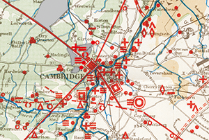
Dense pasts: settlement archaeology after Fox's The archaeology of the Cambridge region (1923)
-
- Article
-
- You have access
- Open access
- HTML
- Export citation
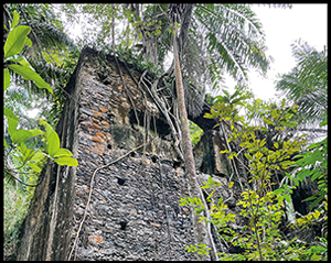
Bitter legacy: archaeology of early sugar plantation and slavery in São Tomé
-
- Article
-
- You have access
- HTML
- Export citation
Mucho más que un puente terrestre: Avances de la arqueología en Panamá. Juan Guillermo Martín and Tomás E. Mendizábal, editors. 2021. Secretaría Nacional de Ciencia, Tecnología e Innovación de Panamá (SENACYT), Ciudad de Panamá. xxii + pp. 336. 74 figs. 11 tables (hardcover), ISBN 978-9962-731-14-6.
-
- Journal:
- Latin American Antiquity / Volume 34 / Issue 3 / September 2023
- Published online by Cambridge University Press:
- 14 August 2023, pp. 694-695
- Print publication:
- September 2023
-
- Article
- Export citation
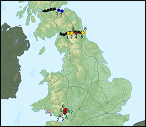
Feeding the Roman Army in Britain
- Part of
-
- Article
-
- You have access
- Open access
- HTML
- Export citation
PRELIMINARY RESULTS FROM GLASGOW INTERNATIONAL RADIOCARBON INTERCOMPARISON
-
- Journal:
- Radiocarbon / Volume 66 / Issue 5 / October 2024
- Published online by Cambridge University Press:
- 14 August 2023, pp. 1302-1309
- Print publication:
- October 2024
-
- Article
- Export citation
Hybrid Material Culture in the Inca Empire (AD 1400–1532): Analyzing the Ceramic Assemblages from La Centinela and Las Huacas, Chincha Valley
-
- Journal:
- Latin American Antiquity / Volume 35 / Issue 3 / September 2024
- Published online by Cambridge University Press:
- 14 August 2023, pp. 576-594
- Print publication:
- September 2024
-
- Article
- Export citation
Embedding Librarians in Archaeological Field Schools
-
- Journal:
- Advances in Archaeological Practice / Volume 11 / Issue 4 / November 2023
- Published online by Cambridge University Press:
- 11 August 2023, pp. 434-441
-
- Article
-
- You have access
- Open access
- HTML
- Export citation
Urban daily life in Late Antiquity - L. Lavan 2020. Public Space in the Late Antique City (2 vols). Part 1: Streets, Processions, Fora, Agorai, Macella, Shops. Part 2: Sites, Buildings, Dates. Late Antique Archaeology (Supplementary Series) 5. Leiden: Brill. Part 1: Pp. xxiv + 624, figs. 130; Part 2: Pp. 1,072. ISBN 978-90-04-41372-6.
-
- Journal:
- Journal of Roman Archaeology / Volume 36 / Issue 2 / December 2023
- Published online by Cambridge University Press:
- 11 August 2023, pp. 598-604
- Print publication:
- December 2023
-
- Article
- Export citation
