Refine search
Actions for selected content:
213073 results in Engineering
Part III - HAP Communication Networks
-
- Book:
- Aerial Access Networks
- Published online:
- 19 October 2023
- Print publication:
- 02 November 2023, pp 133-134
-
- Chapter
- Export citation
Dedication
-
- Book:
- Virtual Reality
- Published online:
- 12 October 2023
- Print publication:
- 02 November 2023, pp v-vi
-
- Chapter
- Export citation
Frontmatter
-
- Book:
- Virtual Reality
- Published online:
- 12 October 2023
- Print publication:
- 02 November 2023, pp i-iv
-
- Chapter
- Export citation
7 - Electrodynamics
-
- Book:
- Introduction to Electrodynamics
- Published online:
- 06 October 2023
- Print publication:
- 02 November 2023, pp 298-360
-
- Chapter
- Export citation
-
Summary
To make a current flow, you have to push on the charges. How fast they move, in response to a given push, depends on the nature of the material. For most substances, the current density
is proportional to the force per unit charge,
Index
-
- Book:
- Introduction to Electrodynamics
- Published online:
- 06 October 2023
- Print publication:
- 02 November 2023, pp 591-602
-
- Chapter
- Export citation
Acknowledgments
-
- Book:
- Virtual Reality
- Published online:
- 12 October 2023
- Print publication:
- 02 November 2023, pp xiv-xiv
-
- Chapter
- Export citation
2 - Aerial Integration
- from Part I - Basics of Aerial Access Networks
-
- Book:
- Aerial Access Networks
- Published online:
- 19 October 2023
- Print publication:
- 02 November 2023, pp 9-18
-
- Chapter
- Export citation
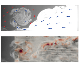
Density effects on streamwise-orientated vorticity at river confluences: a laboratory investigation
-
- Journal:
- Journal of Fluid Mechanics / Volume 973 / 25 October 2023
- Published online by Cambridge University Press:
- 02 November 2023, A7
-
- Article
-
- You have access
- Open access
- HTML
- Export citation
-
Small differences in the densities of a river confluence's tributaries (i.e. 0.5 kg m $^{-3}$) have been proposed to cause coherent streamwise-oriented vortices (SOVs) in its mixing interface. These secondary flow structures are thought to result from density-driven gravity currents being laterally confined between the converging flows. However, empirical evidence for density SOVs and the confined gravity current mechanism is lacking. To this end, experiments are carried out in a laboratory confluence permitting a spectrum of thermal density differences between its tributaries. Particle image velocimetry and laser-induced fluorescence are used simultaneously to study the mixing interface's dynamics. The sensitivity of the mixing interface's secondary flow structure to the confluence's momentum ratio and the magnitude of the density difference is evaluated. Density SOVs are confirmed in the mixing interface and are caused by the gravity currents being confined laterally as the opposing flows merge and accelerate downstream. The SOVs are largest and most coherent when the momentum of the dense channel is greater than that of the light channel. The dynamics of these secondary flow structures is strongly coupled to periodic vertically orientated Kelvin–Helmholtz instabilities. The striking similarities between the empirically reproduced SOVs herein and those recently observed at the Coaticook-Massawippi confluence (Quebec, Canada), despite a two-order magnitude difference in physical scale, suggest density SOVs are a scale-independent flow structure at confluences when specific, yet relatively common, hydraulic and density conditions align.

13 - Frontiers
-
- Book:
- Virtual Reality
- Published online:
- 12 October 2023
- Print publication:
- 02 November 2023, pp 320-339
-
- Chapter
- Export citation
Index
-
- Book:
- Virtual Reality
- Published online:
- 12 October 2023
- Print publication:
- 02 November 2023, pp 364-374
-
- Chapter
- Export citation
12 - Electrodynamics and Relativity
-
- Book:
- Introduction to Electrodynamics
- Published online:
- 06 October 2023
- Print publication:
- 02 November 2023, pp 508-577
-
- Chapter
- Export citation
Image Credits
-
- Book:
- Virtual Reality
- Published online:
- 12 October 2023
- Print publication:
- 02 November 2023, pp 357-363
-
- Chapter
- Export citation
6 - Cooperative HAP and LEO Satellite Schemes for Data Collection and Transmission
- from Part III - HAP Communication Networks
-
- Book:
- Aerial Access Networks
- Published online:
- 19 October 2023
- Print publication:
- 02 November 2023, pp 147-168
-
- Chapter
- Export citation
Part I - Basics of Aerial Access Networks
-
- Book:
- Aerial Access Networks
- Published online:
- 19 October 2023
- Print publication:
- 02 November 2023, pp 7-8
-
- Chapter
- Export citation
Exploration of the state-of-the-art of maritime transport safety research: a bibliometric and visualised analysis
-
- Journal:
- The Journal of Navigation / Volume 76 / Issue 6 / November 2023
- Published online by Cambridge University Press:
- 30 May 2024, pp. 750-772
- Print publication:
- November 2023
-
- Article
- Export citation
Exploration of COLREG-relevant parameters from historical AIS-data
-
- Journal:
- The Journal of Navigation / Volume 76 / Issue 6 / November 2023
- Published online by Cambridge University Press:
- 18 April 2024, pp. 731-749
- Print publication:
- November 2023
-
- Article
-
- You have access
- Open access
- HTML
- Export citation
Introduction
-
- Book:
- Sopwith Triplane
- Published by:
- Amsterdam University Press
- Published online:
- 27 March 2024
- Print publication:
- 01 November 2023, pp 7-44
-
- Chapter
- Export citation
Aircraft built by the Sopwith Aviation Company Ltd.
-
- Book:
- Sopwith Triplane
- Published by:
- Amsterdam University Press
- Published online:
- 27 March 2024
- Print publication:
- 01 November 2023, pp 2-6
-
- Chapter
- Export citation
NAV volume 76 issue 6 Cover and Back matter
-
- Journal:
- The Journal of Navigation / Volume 76 / Issue 6 / November 2023
- Published online by Cambridge University Press:
- 26 February 2025, pp. b1-b2
- Print publication:
- November 2023
-
- Article
-
- You have access
- Export citation
Latitude by two altitudes of the Sun – Douwes’ and Riddle's methods
-
- Journal:
- The Journal of Navigation / Volume 76 / Issue 6 / November 2023
- Published online by Cambridge University Press:
- 12 February 2024, pp. 627-640
- Print publication:
- November 2023
-
- Article
- Export citation
