Refine search
Actions for selected content:
211820 results in Engineering
Appendix B - Preparation of Laboratory Ice Test Samples
-
- Book:
- Mechanics of Ice Failure
- Published online:
- 10 February 2023
- Print publication:
- 02 March 2023, pp 208-210
-
- Chapter
- Export citation
Verification & validation of lifting line $\alpha $- and $\Gamma $-formulations for 3-D planforms under viscous flows
-
- Journal:
- The Aeronautical Journal / Volume 127 / Issue 1314 / August 2023
- Published online by Cambridge University Press:
- 02 March 2023, pp. 1473-1490
-
- Article
- Export citation
-
Many adaptations of the lifting-line theory have been developed since its conception to aid in preliminary aerodynamic wing design, but they typically fall into two main formulations, named $\alpha $- and $\Gamma $-formulation, which differ in terms of the control points chordwise location and the variable updated during the iterative scheme. This paper assess the advantages and drawbacks of both formulations through the implementation of the respective methods and application of standard verification and validation procedures. Verification showed that the $\Gamma $-method poorly converges for wings with nonstraight quarter-chord lines, while the $\alpha $-method presents adequate convergence rates and uncertainties for all geometries; it also showed that the $\Gamma $-method agrees best with analytic results from the cassic lifting-line theory, indicating that it tends to overpredict wing lift. Validation and comparison to other modern lifting-line methods was done for similar geometries, and not only corroborated the poor converge and lift overprediction of the $\Gamma $-method, but also showed that the $\alpha $-method presented the closest results to experimental data for almost all cases tested, concluding that this formulation is typically superior regardless of the wing geometry. These results indicate that the implemented $\alpha $-method has a greater potential for the extension of the lifting-line theory to more geometrically complex lifting surfaces other than fixed wings with straight quarter-chord lines and wakes constrained to the planform plane.


5 - Design for Ice Loading
- from Part I - Basics and Design for Compressive Ice Interactions
-
- Book:
- Mechanics of Ice Failure
- Published online:
- 10 February 2023
- Print publication:
- 02 March 2023, pp 71-82
-
- Chapter
- Export citation
1 - Introduction
- from Part I - Basics and Design for Compressive Ice Interactions
-
- Book:
- Mechanics of Ice Failure
- Published online:
- 10 February 2023
- Print publication:
- 02 March 2023, pp 3-9
-
- Chapter
-
- You have access
- Export citation

Hydrology
- An Introduction
-
- Published online:
- 01 March 2023
- Print publication:
- 23 February 2023
-
- Textbook
- Export citation
NAV volume 76 issue 2-3 Cover and Front matter
-
- Journal:
- The Journal of Navigation / Volume 76 / Issue 2-3 / March 2023
- Published online by Cambridge University Press:
- 15 August 2023, pp. f1-f2
- Print publication:
- March 2023
-
- Article
-
- You have access
- Export citation
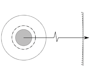
Droplet evaporation in inert gases
-
- Journal:
- Journal of Fluid Mechanics / Volume 958 / 10 March 2023
- Published online by Cambridge University Press:
- 01 March 2023, A18
-
- Article
-
- You have access
- Open access
- HTML
- Export citation
-
A general mixed kinetic-diffusion boundary condition is formulated to account for the out-of-equilibrium kinetics in the Knudsen layer. The mixed boundary condition is used to investigate the problem of quasi-steady evaporation of a droplet in an infinite domain containing inert gases. The widely adopted local thermodynamic equilibrium assumption is found to be the limiting case of infinitely large kinetic Péclet number ${{Pe}_k}$, and it introduces significant error for ${{Pe}_k} \leqslant O(10)$, which corresponds to a typical droplet radius $a$ of a few micrometres or smaller. When compared with experimental data, solutions based on the mixed boundary condition, which take into account the temperature jump across the Knudsen layer, better predict the time evolution of $a$ than the classical $D^2$-law (i.e. $a^2 \propto t$, where $t$ denotes time). In the slow evaporation limit, an analytical solution is obtained by linearising the full formulation about the equilibrium condition, which shows that the $D^2$-law can be recovered only in the large ${{Pe}_k}$ limit. For small ${{Pe}_k}$, where the process is dominated by kinetics, a linear relation, i.e. $a \propto t$, emerges. When the gas phase density approaches the liquid density (e.g. at high-pressure or low-temperature conditions), the increase in the chemical potential of the liquid phase due to the presence of inert gases needs to be accounted for when formulating the mixed boundary condition, an effect largely ignored in the literature so far.


Minimum required accuracy for HD maps
-
- Journal:
- The Journal of Navigation / Volume 76 / Issue 2-3 / March 2023
- Published online by Cambridge University Press:
- 22 June 2023, pp. 238-254
- Print publication:
- March 2023
-
- Article
-
- You have access
- Open access
- HTML
- Export citation
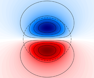
Oceanic dipoles in a surface quasi-geostrophic model
-
- Journal:
- Journal of Fluid Mechanics / Volume 958 / 10 March 2023
- Published online by Cambridge University Press:
- 01 March 2023, R2
-
- Article
-
- You have access
- Open access
- HTML
- Export citation
Ionospheric correction of S-band tracking radar data using NavIC S-band signals in missile test range applications
-
- Journal:
- The Journal of Navigation / Volume 76 / Issue 2-3 / March 2023
- Published online by Cambridge University Press:
- 05 April 2023, pp. 225-237
- Print publication:
- March 2023
-
- Article
- Export citation
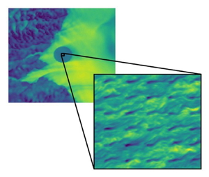
Understanding wind farm power densities
-
- Journal:
- Journal of Fluid Mechanics / Volume 958 / 10 March 2023
- Published online by Cambridge University Press:
- 01 March 2023, F1
-
- Article
-
- You have access
- Open access
- HTML
- Export citation
FLM volume 957 Cover and Front matter
-
- Journal:
- Journal of Fluid Mechanics / Volume 957 / 25 February 2023
- Published online by Cambridge University Press:
- 01 March 2023, p. f1
-
- Article
-
- You have access
- Export citation
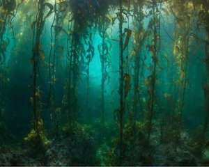
Surface waves and currents in aquatic vegetation
-
- Journal:
- Journal of Fluid Mechanics / Volume 958 / 10 March 2023
- Published online by Cambridge University Press:
- 01 March 2023, A14
-
- Article
-
- You have access
- Open access
- HTML
- Export citation
Characterisation and position-aiding performance analysis of Doppler observation from android smartphones
-
- Journal:
- The Journal of Navigation / Volume 76 / Issue 2-3 / March 2023
- Published online by Cambridge University Press:
- 28 April 2023, pp. 375-393
- Print publication:
- March 2023
-
- Article
- Export citation
A collaborative collision avoidance strategy for autonomous ships under mixed scenarios
-
- Journal:
- The Journal of Navigation / Volume 76 / Issue 2-3 / March 2023
- Published online by Cambridge University Press:
- 05 April 2023, pp. 200-224
- Print publication:
- March 2023
-
- Article
- Export citation
Collision risk quantification for pairs of recorded aircraft trajectories
-
- Journal:
- The Journal of Navigation / Volume 76 / Issue 2-3 / March 2023
- Published online by Cambridge University Press:
- 26 April 2023, pp. 181-199
- Print publication:
- March 2023
-
- Article
-
- You have access
- Open access
- HTML
- Export citation
NAV volume 76 issue 2-3 Cover and Back matter
-
- Journal:
- The Journal of Navigation / Volume 76 / Issue 2-3 / March 2023
- Published online by Cambridge University Press:
- 15 August 2023, pp. b1-b2
- Print publication:
- March 2023
-
- Article
-
- You have access
- Export citation
Robust train localisation method based on advanced map matching measurement-augmented tightly-coupled GNSS/INS with error-state UKF
-
- Journal:
- The Journal of Navigation / Volume 76 / Issue 2-3 / March 2023
- Published online by Cambridge University Press:
- 12 May 2023, pp. 316-339
- Print publication:
- March 2023
-
- Article
- Export citation
Resolving problems in symbol identification in compilation of electronic navigational charts utilising paper charts
-
- Journal:
- The Journal of Navigation / Volume 76 / Issue 2-3 / March 2023
- Published online by Cambridge University Press:
- 29 June 2023, pp. 394-411
- Print publication:
- March 2023
-
- Article
- Export citation
A clustering-based method for estimating pennation angle from B-mode ultrasound images
- Part of
-
- Journal:
- Wearable Technologies / Volume 4 / 2023
- Published online by Cambridge University Press:
- 01 March 2023, e6
-
- Article
-
- You have access
- Open access
- HTML
- Export citation
