Refine search
Actions for selected content:
95781 results in Archaeology
Chapter Five - The Neolithic Revolution in the Caucasus
-
- Book:
- The Peopling of the Caucasus
- Published online:
- 21 January 2025
- Print publication:
- 23 January 2025, pp 51-61
-
- Chapter
- Export citation
Indicadores de intensificación y aprovechamiento alimenticio de camélidos en la Puna de Salta, Argentina
-
- Journal:
- Latin American Antiquity / Volume 36 / Issue 3 / September 2025
- Published online by Cambridge University Press:
- 23 January 2025, pp. 658-677
- Print publication:
- September 2025
-
- Article
- Export citation
Works Cited
-
- Book:
- The Peopling of the Caucasus
- Published online:
- 21 January 2025
- Print publication:
- 23 January 2025, pp 222-302
-
- Chapter
- Export citation
Arqueología de paisajes emergentes: Historia ocupacional y formacional de Cerro de los Gatos (Tierra del Fuego, Argentina)
-
- Journal:
- Latin American Antiquity / Volume 36 / Issue 3 / September 2025
- Published online by Cambridge University Press:
- 23 January 2025, pp. 737-757
- Print publication:
- September 2025
-
- Article
- Export citation
Primeras evidencias de cultivo europeo en el sitio Pueblo Guayascate 1 (Córdoba, Argentina): Siglos dieciséis y diecisiete
-
- Journal:
- Latin American Antiquity / Volume 36 / Issue 3 / September 2025
- Published online by Cambridge University Press:
- 23 January 2025, pp. 562-577
- Print publication:
- September 2025
-
- Article
- Export citation
Chapter Two - Geography and Ecology of the Caucasus
-
- Book:
- The Peopling of the Caucasus
- Published online:
- 21 January 2025
- Print publication:
- 23 January 2025, pp 9-15
-
- Chapter
- Export citation
Chapter Four - Modern Human Entry into the Caucasus
-
- Book:
- The Peopling of the Caucasus
- Published online:
- 21 January 2025
- Print publication:
- 23 January 2025, pp 33-50
-
- Chapter
- Export citation
Chapter Seven - Linguistic Diversity in the Caucasus
-
- Book:
- The Peopling of the Caucasus
- Published online:
- 21 January 2025
- Print publication:
- 23 January 2025, pp 93-114
-
- Chapter
- Export citation
Glossary
-
- Book:
- The Peopling of the Caucasus
- Published online:
- 21 January 2025
- Print publication:
- 23 January 2025, pp 217-220
-
- Chapter
- Export citation
Contents
-
- Book:
- The Peopling of the Caucasus
- Published online:
- 21 January 2025
- Print publication:
- 23 January 2025, pp vii-vii
-
- Chapter
- Export citation
Chapter Ten - Further Research into the Peopling of the Caucasus
-
- Book:
- The Peopling of the Caucasus
- Published online:
- 21 January 2025
- Print publication:
- 23 January 2025, pp 209-216
-
- Chapter
- Export citation
Chapter Six - The Caucasus Chalcolithic and Bronze Age
-
- Book:
- The Peopling of the Caucasus
- Published online:
- 21 January 2025
- Print publication:
- 23 January 2025, pp 62-92
-
- Chapter
- Export citation
Chapter Three - Paleoanthropology of the Caucasus
-
- Book:
- The Peopling of the Caucasus
- Published online:
- 21 January 2025
- Print publication:
- 23 January 2025, pp 16-32
-
- Chapter
- Export citation
Index
-
- Book:
- The Peopling of the Caucasus
- Published online:
- 21 January 2025
- Print publication:
- 23 January 2025, pp 303-310
-
- Chapter
- Export citation
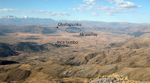
Settlement discontinuity at Ak'awillay and the development of the Inca imperial capital region
-
- Article
-
- You have access
- Open access
- HTML
- Export citation
‘Symbolically Overloaded’ Burials: Early Fourth-Millennium bc Hunter-Fisher-Gatherer Mortuary Practices from North-Eastern Europe
-
- Journal:
- European Journal of Archaeology / Volume 28 / Issue 2 / May 2025
- Published online by Cambridge University Press:
- 22 January 2025, pp. 164-182
-
- Article
-
- You have access
- Open access
- HTML
- Export citation
The Peopling of the Caucasus
- Early Human Settlement at the Crossroads of Continents
-
- Published online:
- 21 January 2025
- Print publication:
- 23 January 2025
Evaluating sulfur-impurity removal and modern carbon contamination in different preparation methods for radiocarbon dating of soil samples by accelerator mass spectrometry
-
- Journal:
- Radiocarbon / Volume 67 / Issue 2 / April 2025
- Published online by Cambridge University Press:
- 21 January 2025, pp. 307-317
- Print publication:
- April 2025
-
- Article
- Export citation
Accessing old carbon influence on TOC 14C age and environmental change from the recent sediments in Lake Shira, Russia
-
- Journal:
- Radiocarbon / Volume 68 / Issue 1 / February 2026
- Published online by Cambridge University Press:
- 21 January 2025, pp. 95-118
- Print publication:
- February 2026
-
- Article
-
- You have access
- Open access
- HTML
- Export citation
Monsoon-regulated marine carbon reservoir effect in the northern South China Sea
-
- Journal:
- Radiocarbon / Volume 67 / Issue 2 / April 2025
- Published online by Cambridge University Press:
- 21 January 2025, pp. 412-427
- Print publication:
- April 2025
-
- Article
- Export citation
