We use cookies to distinguish you from other users and to provide you with a better experience on our websites. Close this message to accept cookies or find out how to manage your cookie settings.
To save content items to your account,
please confirm that you agree to abide by our usage policies.
If this is the first time you use this feature, you will be asked to authorise Cambridge Core to connect with your account.
Find out more about saving content to .
To save content items to your Kindle, first ensure no-reply@cambridge.org
is added to your Approved Personal Document E-mail List under your Personal Document Settings
on the Manage Your Content and Devices page of your Amazon account. Then enter the ‘name’ part
of your Kindle email address below.
Find out more about saving to your Kindle.
Note you can select to save to either the @free.kindle.com or @kindle.com variations.
‘@free.kindle.com’ emails are free but can only be saved to your device when it is connected to wi-fi.
‘@kindle.com’ emails can be delivered even when you are not connected to wi-fi, but note that service fees apply.
The Richtmyer–Meshkov instability at gas interfaces with controllable initial perturbation spectra under reshock conditions is investigated both experimentally and theoretically. A soap-film method is adopted to generate well-defined single-, dual- and triple-mode air/SF$_6$ interfaces. By inserting an acrylic block into the test section, a reflected shock with controllable reshock timing is created. The results reveal a complex relationship between the post-reshock perturbation growth rate and the pre-reshock interface morphology. For single-mode interfaces, the post-reshock growth rate exhibits a strong dependence on pre-reshock conditions. In contrast, for multi-mode interfaces, this dependence weakens significantly due to mode-coupling effects. It is found that, following reshock, each fundamental mode develops independently and later is significantly influenced by mode-coupling effects. Based on this finding, we propose an empirical model that matches the initial linear growth rate and the asymptotic growth rate, accurately predicting the evolution of fundamental modes from early to late stages across all three configurations. Furthermore, a theoretical formula is derived, linking the empirical coefficient in the model of Charakhch’An (2020 J. Appl. Mech. Tech. Phys. vol. 41, no. 1, pp. 23–31) to the initial perturbation. This provides a unified framework to explain the varying dependence of post-reshock growth rates on pre-reshock morphology observed in previous experiments.
We report the first measurement of turbulent mixing developing from the convergent Richtmyer–Meshkov (RM) instability using time-resolved planar laser-induced fluorescence in a semi-annular convergent shock tube. A membraneless yet sharp interface with random short-wavelength perturbations, but controllable long-wavelength perturbations, is created by an automatically retractable plate, enhancing the reproducibility and reliability of RM turbulence experiments. The cylindrical air/SF$_6$ interface formed is first subjected to a convergent shock, then to its reflected shock and subsequently transits to turbulent mixing. It is found that the mixing width after reshock has a linear growth rate more than twice the rate in planar geometry. Also, the mixing width does not present power-law growth at late stages as in a planar geometry. However, the scalar spectrum and transition criterion obtained are similar to their planar counterparts. These findings indicate that the geometric constraint greatly affects the large scales of the flow, while having a weaker effect on the small scales. It is also found that the reflected shock significantly increases both scale separation and Reynolds number, explaining the rapid transition to turbulence following reshock.
This study provides a business history of the construction project to build a large Anglican church in colonial Shanghai in the 1860s. Employing three theoretical lenses, it focusses on the project’s management, setting it in its social, political, economic and architectural contexts. As well as analysing the project’s progress in detail, the paper discloses circumstances that were being faced more generally by resident British and international traders in Shanghai at this unsettled time. It also identifies forces which would in due course influence the long process of change leading to the eventual transformation both of Shanghai and of China itself, enhancing our understanding of the region’s economic history.
The reshocked Richtmyer–Meshkov instability (RMI) is examined in three different configurations via shock-tube experiments: RMI at a single-mode interface with a planar reshock (configuration I); RMI at a flat interface with a sinusoidal reshock (configuration II); RMI at a single-mode interface with a sinusoidal reshock (configuration III). The sinusoidal reshock is created by an incident shock reflecting off a sine-shaped wall surface. For all three configurations, the initial conditions of the experiment are specially set such that the interface evolution is at the linear stage when the reshock arrives. It is found that the amplitude of the reshocked interface increases linearly with time for all three configurations. For configuration I, the post-reshock perturbation growth depends heavily on the pre-reshock amplitude and growth rate, which can be predicted by a modified Mikaelian model (Phys. Rev. A, vol. 31, 1985, pp. 410–419). For configuration II, velocity perturbation associated with the non-uniform rippled reshock plays an important role in the instability growth. For configuration III, the post-reshock instability growth is much quicker (lower) than in configuration I when the sinusoidal reshock is in phase (out of phase) with the interface. A major reason is that for the in-phase (anti-phase) case, the velocity perturbation gives rise to an instability growth with an identical (opposite) direction to the pressure perturbation. A linear theory is developed that takes velocity perturbation, pressure perturbation and pre-reshock growth rate into account, which gives a reasonable prediction of the growth of the reshocked RMI in configurations II and III.
To comprehensively study the physical properties of inductively coupled plasma (ICP), a finite element method (FEM) simulation model of ICP is developed using the well-established COMSOL software. To benchmark the validation of the FEM model, two key physical parameters, the electron density and the electron temperature of the ICP plasma, are precisely measured by the state-of-the-art laser Thomson scattering diagnostic approach. For low-pressure plasma such as ICP, the local pressure in the generator tube is difficult to measure directly. The local gas pressure in the ICP tube has been calibrated by comparing the experimental and simulation results of the maximum electron density. And on this basis, the electron density and electron temperature of ICP under the same gas pressure and absorbed power have been compared by experiments and simulations. The good agreement between the experimental and simulation data of these two key physical parameters fully verifies the validity of the ICP FEM simulation model. The experimental verification of the ICP FEM simulation model lays a foundation for further study of the distribution of various physical quantities and their variation with pressure and absorption power, which is beneficial for improving the level of ICP-related processes.
The Wood Snipe Gallinago nemoricola is one of the least known shorebird species, and its habitat associations are very poorly understood. Here we provide the first assessment of the habitat use of the Wood Snipe during the breeding season. Between May and July 2021 at a 4-km2 alpine meadow in Sichuan province, China, we conducted population surveys and behavioural observations to identify sites where breeding Wood Snipe occurred and foraged. We quantified the habitat characteristics and food resource availability of these sites and compared them with randomly selected “background” sites. Comparison between 34 occurrence sites and 25 background sites indicated that during the breeding season, Wood Snipes are not distributed evenly across alpine meadow habitats, but preferred habitats in the lower part (3,378–3,624 m) of the alpine meadow with intermediate levels of soil moisture. In addition, comparison between 17 foraging sites and 24 background sites showed that the Wood Snipe tended to forage at sites with higher soil fauna abundance. We found weak evidence for denser vegetation cover at its height and no evidence for other biotic habitat variables such as vegetation composition or other abiotic habitat variables such as slope, soil penetrability, or disturbance level to influence Wood Snipe habitat associations. Our results suggest that the actual distribution range of the Wood Snipe during the breeding season may be smaller than expected from the extent of apparently suitable habitat. We advise caution in evaluating the potential habitat availability and distribution of the Wood Snipe, and call for further research to better understand the ecology of this rare species to inform its conservation.
Dongxiang wild rice (Oryza rufipogon Griff.) (DXWR) is the northernmost distributed wild rice found in the world. Similar to other populations of O. rufipogon, DXWR contains a large number of agronomically valuable genes, which makes it a natural gene pool for rice breeding. Molecular markers, especially simple repeat sequence (SSR) markers, play important roles in plant breeding. Although a large number of SSR markers have been developed, most of them are derived from the genome coding sequences, rarely from non-coding sequences. Meanwhile, long non-coding RNAs (lncRNAs), which are derived from the transcription of non-coding sequences, play vital roles in plant growth, development and stress responses. In our previous study, we obtained 1655 lncRNA transcripts from DXWR using strand-specific RNA sequencing. In this study, 1878 SSR loci were detected from the lncRNA sequences of DXWR, and 1258 lncRNA-derived-SSR markers were developed on the genome-wide scale. To verify the validity and applicability of these markers, 72 pairs of primers were randomly selected to test 44 rice accessions. The results showed that 42 (58.33%) pairs of primers have abundant polymorphism among these rice materials; the polymorphism information content values ranged from 0.04 to 0.87 with an average of 0.50; the genetic diversity index of SSR loci varied from 0.04 to 0.88 with an average of 0.56; and the number of alleles per marker ranged from 2 to 11 with an average of 4.36. Thus, we concluded that these lncRNA-derived-SSR markers are a very useful source for future basic and applied research.
The southeastern Central Asian Orogenic Belt (CAOB) records the assembly process between several micro-continental blocks and the North China Craton (NCC), with the consumption of the Paleo-Asian Ocean (PAO), but whether the S-wards subduction of the PAO beneath the northern NCC was ongoing during Carboniferous–Permian time is still being debated. A key issue to resolve this controversy is whether the Carboniferous magmatism in the northern NCC was continental arc magmatism. The Alxa Block is the western segment of the northern NCC and contiguous to the southeastern CAOB, and their Carboniferous–Permian magmatism could have occurred in similar tectonic settings. In this contribution, new zircon U–Pb ages, elemental geochemistry and Sr–Nd isotopic analyses are presented for three early Carboniferous granitic plutons in the southwestern Alxa Block. Two newly identified aluminous A-type granites, an alkali-feldspar granite (331.6 ± 1.6 Ma) and a monzogranite (331.8 ± 1.7 Ma), exhibit juvenile and radiogenic Sr–Nd isotopic features, respectively. Although a granodiorite (326.2 ± 6.6 Ma) is characterized by high Sr/Y ratios (97.4–139.9), which is generally treated as an adikitic feature, this sample has highly radiogenic Sr–Nd isotopes and displays significantly higher K2O/Na2O ratios than typical adakites. These three granites were probably derived from the partial melting of Precambrian continental crustal sources heated by upwelling asthenosphere in lithospheric extensional setting. Regionally, both the Alxa Block and the southeastern CAOB are characterized by the formation of early Carboniferous extension-related magmatic rocks but lack coeval sedimentary deposits, suggesting a uniform lithospheric extensional setting rather than a simple continental arc.
South-east Asia's diverse coastal wetlands, which span natural mudflats and mangroves to man-made salt pans, offer critical habitat for many migratory waterbird species in the East Asian–Australasian Flyway. Species dependent on these wetlands include nearly the entire population of the Critically Endangered spoon-billed sandpiper Calidris pygmaea and the Endangered spotted greenshank Tringa guttifer, and significant populations of several other globally threatened and declining species. Presently, more than 50 coastal Important Bird and Biodiversity Areas (IBAs) in the region (7.4% of all South-east Asian IBAs) support at least one threatened migratory species. However, recent studies continue to reveal major knowledge gaps on the distribution of migratory waterbirds and important wetland sites along South-east Asia's vast coastline, including undiscovered and potential IBAs. Alongside this, there are critical gaps in the representation of coastal wetlands across the protected area networks of many countries in this region (e.g. Viet Nam, Indonesia, Malaysia), hindering effective conservation. Although a better understanding of the value of coastal wetlands to people and their importance to migratory species is necessary, governments and other stakeholders need to do more to strengthen the conservation of these ecosystems by improving protected area coverage, habitat restoration, and coastal governance and management. This must be underpinned by the judicious use of evidence-based approaches, including satellite-tracking of migratory birds, ecological research and ground surveys.
Singapore is prominent in the global trade of pet birds, primarily parrots. This includes its role as a key international transit hub, and also its growing domestic market, including for threatened species. There is a need to understand the trade beyond volumes and flows, including consumer knowledge, preferences and behaviours, and interactions with vendors, hobbyist groups and supporting industries. We used three methods to examine this: (1) a questionnaire with stakeholders (including parrot owners, hobbyist group members, breeders and supporting industry professionals), about the motivations for parrot ownership and interest in sustainable trade, (2) semi-structured interviews with key informants about trade dynamics, and (3) a review of online hobbyist groups. Based on our findings, we provide an initial mapping of the country's parrot trade ecosystem. Fifty-one per cent of respondents claimed to be a member of a parrot hobbyist group and 64% agreed their participation in such groups had encouraged them to purchase more parrots. The majority (71%) of parrot owners reported a preference for captive-bred rather than wild-caught parrots, and 72% were concerned about the illegal hunting of parrots for commercial trade. Most were willing to pay more (70%) and wait longer (73%) to procure a sustainably sourced parrot. Our approach presents the wildlife trade as a complex social phenomenon, with multiple physical and online channels, regulatory challenges, social networks, and evolving consumer preferences. We also document the pivotal role of hobbyist groups and their untapped potential to leverage these networks to improve sustainable trade.
Impedance spectroscopy was conducted on colloidal ITO thin films that had been subjected to alternating oxygen and argon plasma treatments, followed by air annealing from 150 to 750 °C. An equivalent circuit consisting of an RC element nested within another RC element, featuring a negative resistance and a negative capacitance, fitted the data well. These results are interpreted as being due to surface plasmons that are a function of the presence of nanoporous ITO-rich regions surrounded by isolated ITO nanoparticles coated with an amorphous polymer that intertwines with the ITO-rich regions as a function of annealing treatment.
The continental shelf strata provide information regarding sea-level fluctuation and climate changes in the Quaternary period. A 5831.47-km-long high-resolution seismic profile and borehole core (YS01) were acquired to reconstruct the evolutionary history of the strata in South Yellow Sea (SYS) during the late Pleistocene. The strata recorded three transgression events (HI, HII, and HIII) and three stages of paleochannel development (LI, LII, and LIII). Based on the distribution, thickness, and volume of the strata formed in the three transgressions, we concluded that the scale of the three transgressions during the late Pleistocene was HIII, HI, and HII, in descending order. In addition, our data show that the Yellow River extended to the Yellow Sea Trough during the last glacial maximum. The influence of the tectonic framework on sedimentation in the SYS was completely concealed by sea-level changes and sediment supply in the late Pleistocene (~Marine Isotope Stage 5). Since then, the accommodation space, a crucial prerequisite for sedimentation, has been controlled solely by sea-level changes in the SYS. Furthermore, two “source to sink” models of the neritic shelf in the marine and terrestrial environments were established, including high sea-level and shelf-exposure models.
South-East Asia’s bird trade is of global conservation concern as it has massively depleted wild populations of many species. Parrots (Order Psittaciformes) are especially vulnerable because they are the most heavily traded group of birds globally under the Convention on International Trade in Endangered Species (CITES) appendices. Singapore’s involvement in the global pet bird trade as a transhipment hub is well documented, particularly for parrots. Yet, much less is known about the links between its domestic and international trade. We attempt to quantify this relationship by comparing bird trade data on the CITES database with past market surveys of pet shops, complemented with semi-structured interviews with 30 parrot owners in Singapore. We report a decline in total imports and exports of CITES-listed birds in Singapore from 2005 to 2016, consistent with global trends after the European Union trade ban on wild bird imports. However, parrots continue to make up the majority of total imports; and there was a yearly increase in the percentage of parrot imports out of total imports. In addition, we report a difference in imports and exports of 54,207 CITES I, II and III listed birds into Singapore i.e. birds imported but not re-exported. A substantial proportion of these birds were possibly channelled into the domestic pet trade or used as breeding stock. Interviews with parrot owners confirmed the growing demand and popularity of parrots and particularly of larger species. We conclude that the domestic demand for parrots may have been previously underestimated, and make recommendations to manage Singapore’s international and domestic pet bird trade such as implementing a licensing and records system to track the movement of birds.
Precise Point Positioning/Inertial Navigation System (PPP/INS) integrated navigation based on PPP and low-accuracy INS is often used to provide position and attitude information for vehicle-mounted or airborne mobile mapping systems. With proper processing, the position accuracy of PPP/INS is comparable to that of Differential Global Navigation Satellite System (DGNSS)/INS, but the accuracy of the attitude, especially the yaw angle, cannot be guaranteed. However, the yaw angle is crucial for mobile mapping systems. To compensate for the insufficiency of PPP/INS, we have designed a Multi-Antenna GNSS (MAGNSS)/INS integrated navigation system. First, the attitude determination method using MAGNSS is presented in detail. Then, the MAGNSS attitude is combined with the PPP position and velocity as measurements for integration with the INS. Thus, PPP/INS integrated navigation was improved to MAGNSS/INS integrated navigation. Finally, a three-hour car-borne test was conducted to evaluate the performance of the proposed method. The results indicate that the attitude determined from MAGNSS is accurate and stable over time. Compared to PPP/INS, MAGNSS/INS integrated navigation can improve the attitude accuracy significantly because of the inclusion of MAGNSS attitude.
Thermal and hydrological dynamics and their impacts on the stability of a moraine dam were analyzed and simulated for the Longbasaba Lake in the Himalaya, based on soil temperature, moisture and heat flux data observed at different depths in the dam from 2012 to 2016. Annual average heat income is greater than heat expenditure on the dam surface. The mean annual temperature at observed the depths of 0–150 cm is >0°C, although the average annual air temperature was −3.6°C over the dam, indicating a relatively larger temperature difference between moraine dam and air. The volumetric soil moisture content is relatively low with an annual average of 5%, peaking after the snow cover melting and active layer thawing. Simulation results indicate that the average yearly maximum thawing depth has been ~0.3 m deeper than the average yearly maximum freezing depth during the observation period. In the past 55 years, the yearly maximum thawing depth has increased, while yearly maximum freezing depth has decreased, implying that the permafrost in the dam has been deteriorating. The annual surplus heat and increasing permafrost thawing depth will result in further deterioration of permafrost and melting of buried ice in the dam, thereby decreasing its stability.
In this paper, we prove that the singular integral defined by
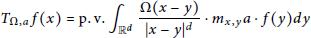
${{T}_{\Omega ,a}}f(x)=\text{p}\text{.}\text{v}\text{.}{{\int }_{{{\mathbb{R}}^{d}}}}\frac{\Omega (x-y)}{|x-y{{|}^{d}}}\cdot {{m}_{x,y}}a\cdot f(y)dy$is bounded on ${{L}^{p}}({{\mathbb{R}}^{d}})$ for $1\,<\,p\,<\,\infty $ and is of weak type (1,1), where 
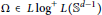
$\Omega \,\in L\text{lo}{{\text{g}}^{+}}L({{S}^{d-1}})$ and 
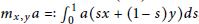
${{m}_{x,y}}a\,=:\,\int{_{0}^{1}}\,a(sx\,+\,(1\,-\,s)y)ds$, with $a\,\in \,{{L}^{\infty }}({{\mathbb{R}}^{d}})\,$ satisfying some restricted conditions.
A so-called ‘warm and wet transition’ of climate has occurred in the arid part of northwestern China since the late 1980s. A result of this climatic transition is an increase in runoff in Xinjiang and neighboring regions. In a warming and wetting change-of-climate scenario, we attempt to evaluate the impact of glacier meltwater and precipitation on the increase in outlet discharge (runoff) from Keqicar Baqi glacier, southwestern Tien Shan, China. In our research we have applied a degree-day model which is one of the most widely used methods of ice- and snowmelt computations for a multitude of purposes such as hydrological modeling, ice-dynamic modeling and climate sensitivity studies. It is concluded that under the warming and wetting scenario, the primary supply for the runoff in this catchment is glacier meltwater, with precipitation being the dominant secondary source; 84% and 8% of total runoff, respectively.
Recent studies have indicated that widespread wastage of glaciers in western China has occurred since the late 1970s. By using digitized glacier outlines derived from the 1970 inventory and Landsat satellite data from 1990/91 to 2001, we obtained area changes of about 278 glaciers with a total area of 2711.57 km2 in the heavily glaciated west Kunlun Shan (WKS) in the northern Tibetan Plateau (TP). Results indicate that the prevailing characteristic of glacier variation is ice wastage, and glacier area decreased by 10 km2 (0.4% of the total 1970 area) between 1970 and 2001. Both the south and north slopes of the WKS presented shrinkage during 1970–2001, but whereas on the north slope a slight enlargement of ice extent during 1970–90 was followed by a reduction of 0.2% during 1990–2001, on the south slope the glacier area decreased by 1.2% during 1970–91, with a small increment of 0.6% during 1991–2001. Comparisons with other glaciated mountainous regions in western China show that glaciers in the research area have experienced less retreat. Based on records from the Guliya ice core, we believe that an increase in air temperature was the main forcing factor for glacier shrinkage during 1970–2001.
The Tarim river basin, a river system formed by the convergence of nine tributaries, is the most heavily glacierized watershed in arid northwest China. In the basin, there are 11 665 glaciers with a total area of 19 878 km2 and a volume of 2313 km3. Glaciers in the basin play a significant role in the water resource system. It is estimated that they provide about 133 x 108 m3 of meltwater annually, contributing 39% of the total river runoff. Under the influence of global warming, northwest China has experienced a generally warmer and drier climate since the mid-19th century. However, a so-called ‘warm and wet transition’ has occurred since the late 1980s, evidenced by an increase in both precipitation and stream discharge in the Xinjiang Autonomous Region and neighboring regions. This paper describes how glaciers in the Tarim river basin have responded to such warming and increased precipitation, and the impact of these glacier changes. We analyzed the variations of more than 3000 glaciers since the 1960s using topographical maps, high-resolution satellite images and aerial photographs of the river basin. Our results indicate that glaciers in the basin have been mostly in retreat in the past 40 years, and ice wastage has significantly influenced water resources in the Tarim river basin. Estimation by a degree-day meltwater model shows the positive anomaly in stream runoff of the Tailan river can be partly attributed to the increase in glacier runoff (amounting to one-third of the stream discharge), and a rough estimation using observed average ablation on the termini of 15 glaciers in China verifies that the mass loss calculated by a glacier area-volume relation is reasonable.
The degree-day factor (DDF) is an important parameter for the degree-day model, which is a widely used method for ice- and snowmelt computation. Spatial variations of the DDF greatly affect the accuracy of snow- and ice-melt modelling. This study analyzes the spatial variability of DDFs obtained from observed glaciers in different regions of western China. The results clearly show that the DDF for a single glacier is subject to significant small-scale variations, and the factor for maritime glaciers is higher than that for subcontinental and extremely continental glaciers. In western China the factors increase gradually from northwest to southeast. In general, the regional patterns of DDFs are detectable on the glaciers due to the unique climatic environment and heat budget of the Tibetan Plateau and surrounding regions. Low DDFs can be expected for cold-dry areas, whereas high DDFs can be expected for warm-wet areas in western China. Depending on spatial variation of the characteristics of DDFs and the meteorological data, we can provide gridded degree-day models for non-monitored glaciers to reconstruct gridded historical glacier mass-balance series in western China.