Refine listing
Actions for selected content:
50 results in AGU Journals Article Collection
Particle trajectories, velocities, accelerations and rotation rates in snow avalanches
- Part of
-
- Journal:
- Annals of Glaciology / Volume 65 / 2024
- Published online by Cambridge University Press:
- 31 October 2023, e9
-
- Article
-
- You have access
- Open access
- HTML
- Export citation
The signature of accumulated permanent uplift, northern Cascadia subduction zone
-
- Journal:
- Quaternary Research / Volume 117 / January 2024
- Published online by Cambridge University Press:
- 31 October 2023, pp. 98-118
-
- Article
-
- You have access
- Open access
- HTML
- Export citation
Multiple sediment source infill in a low-accommodation basin: implications for the late Paleozoic sediment routing system in the southeastern Ordos Basin
-
- Journal:
- Geological Magazine / Volume 160 / Issue 9 / September 2023
- Published online by Cambridge University Press:
- 31 October 2023, pp. 1649-1672
-
- Article
-
- You have access
- Open access
- HTML
- Export citation
Flow structure transition in thermal vibrational convection
-
- Journal:
- Journal of Fluid Mechanics / Volume 974 / 10 November 2023
- Published online by Cambridge University Press:
- 31 October 2023, A29
-
- Article
-
- You have access
- Open access
- HTML
- Export citation
-
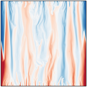
This study investigates the effect of vibration on the flow structure transitions in thermal vibrational convection (TVC) systems, which occur when a fluid layer with a temperature gradient is excited by vibration. Direct numerical simulation (DNS) of TVC in a two-dimensional enclosed square box is performed over a range of dimensionless vibration amplitudes
 $0.001 \le a \le 0.3$ and angular frequencies
 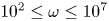 $10^{2} \le \omega \le 10^{7}$, with a fixed Prandtl number of 4.38. The flow visualisation shows the transition behaviour of flow structure upon the varying frequency, characterising three distinct regimes, which are the periodic-circulation regime, columnar regime and columnar-broken regime. Different statistical properties are distinguished from the temperature and velocity fluctuations at the boundary layer and mid-height. Upon transition into the columnar regime, columnar thermal coherent structures are formed, in contrast to the periodic oscillating circulation. These columns are contributed by the merging of thermal plumes near the boundary layer, and the resultant thermal updrafts remain at almost fixed lateral position, leading to a decrease in fluctuations. We further find that the critical point of this transition can be described nicely by the vibrational Rayleigh number
  ${{Ra}}_{vib}$. As the frequency continues to increase, entering the so-called columnar-broken regime, the columnar structures are broken, and eventually the flow state becomes a large-scale circulation (LSC), characterised by a sudden increase in fluctuations. Finally, a phase diagram is constructed to summarise the flow structure transition over a wide range of vibration amplitude and frequency parameters.


Characterizing bed roughness on the Antarctic continental margin
-
- Journal:
- Journal of Glaciology / Volume 69 / Issue 278 / December 2023
- Published online by Cambridge University Press:
- 31 October 2023, pp. 2114-2125
-
- Article
-
- You have access
- Open access
- HTML
- Export citation
Universal law of skin-friction coefficient in a fully developed zero pressure gradient axisymmetric turbulent boundary layer flow
-
- Journal:
- Journal of Fluid Mechanics / Volume 974 / 10 November 2023
- Published online by Cambridge University Press:
- 31 October 2023, A31
-
- Article
- Export citation
-
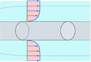
Understanding the skin friction in an axisymmetric turbulent boundary layer (ATBL) flow is a key to designing and optimising the flow past axisymmetric bodies, for example, a rocket engine nozzle and a submarine hull. In this study, we propose a universal law of the skin-friction coefficient in an ATBL flow. The flow is steady and fully developed with a zero pressure gradient. The governing equation for the ATBL flow is derived by methodically applying the boundary layer approximation. Subsequently, the scaling law of the Reynolds shear stress, caused by turbulent eddies, at the surface tangential to the wall roughness summits is derived by incorporating the role of transverse curvature. The skin-friction coefficient in a smooth ATBL flow is found to depend on two parameters, namely, the Reynolds number based on the cylinder radius, Rea, and the ratio of boundary layer thickness to cylinder radius, δ/a. The analysis predicts a simple form of the skin-friction coefficient as
 ${C_f} = 4.56 \times {10^{ - 2}}{[R{e_a}\ln (1 + \delta /a)]^{ - 1/4}}$, which agrees satisfactorily with the available experimental data and the numerical simulations in all the axisymmetric flow regimes. The proposed law, in the limit of infinite radius, is consistent with the classical law of the skin-friction coefficient in a plane turbulent boundary layer flow as
 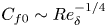 ${C_{f0}}\sim Re_\delta ^{ - 1/4}$, where Reδ is the Reynolds number based on the boundary layer thickness. This study reveals that, for δ/a < 1, the relative skin-friction coefficient,
  $({C_f} - {C_{f0}})/{C_{f0}}$, follows a linear law with δ
 $/$a.
$/$a.


A method for imaging water transport in soil–snow systems withneutron radiography
- Part of
-
- Journal:
- Annals of Glaciology / Volume 65 / 2024
- Published online by Cambridge University Press:
- 31 October 2023, e8
-
- Article
-
- You have access
- Open access
- HTML
- Export citation
Climatic and cave settings influence on drip water fluorescent organic matter with implications for fluorescent laminations in stalagmites
-
- Journal:
- Quaternary Research / Volume 118 / March 2024
- Published online by Cambridge University Press:
- 31 October 2023, pp. 41-61
-
- Article
-
- You have access
- Open access
- HTML
- Export citation
The prevalence of invertebrate bioerosion on Mesozoic marine reptile bone from the Jurassic and Cretaceous of the United Kingdom: new data and implications for taphonomy and environment
-
- Journal:
- Geological Magazine / Volume 160 / Issue 9 / September 2023
- Published online by Cambridge University Press:
- 31 October 2023, pp. 1701-1710
-
- Article
-
- You have access
- Open access
- HTML
- Export citation
Historical occurrence of Antarctic icebergs within mercantile shipping routes and the exceptional events of the 1890s
-
- Journal:
- Journal of Glaciology / Volume 69 / Issue 278 / December 2023
- Published online by Cambridge University Press:
- 27 October 2023, pp. 2046-2058
-
- Article
-
- You have access
- Open access
- HTML
- Export citation
Public support for Antarctic science: lessons from a national survey of Australians
-
- Journal:
- Antarctic Science / Volume 35 / Issue 6 / December 2023
- Published online by Cambridge University Press:
- 26 October 2023, pp. 473-484
-
- Article
-
- You have access
- Open access
- HTML
- Export citation
Has Russia heard about the European Union’s Arcticness? The EU’s Arctic steps as seen from Russia – CORRIGENDUM
-
- Journal:
- Polar Record / Volume 59 / 2023
- Published online by Cambridge University Press:
- 20 October 2023, e34
-
- Article
-
- You have access
- HTML
- Export citation
The impact of the Neoglacial and other environmental changes on the raised beaches of Joinville Island, Antarctica
-
- Journal:
- Antarctic Science / Volume 35 / Issue 6 / December 2023
- Published online by Cambridge University Press:
- 19 October 2023, pp. 418-437
-
- Article
-
- You have access
- Open access
- HTML
- Export citation
Vulnerability of wilderness areas to day-use visits
-
- Journal:
- Environmental Conservation / Volume 51 / Issue 1 / March 2024
- Published online by Cambridge University Press:
- 19 October 2023, pp. 36-44
-
- Article
-
- You have access
- Open access
- HTML
- Export citation
Can China change the Arctic regime?
-
- Journal:
- Polar Record / Volume 59 / 2023
- Published online by Cambridge University Press:
- 18 October 2023, e33
-
- Article
-
- You have access
- Open access
- HTML
- Export citation
The cost of pediatric abdominal tuberculosis treatment in India: Evidence from a teaching hospital
-
- Journal:
- Experimental Results / Volume 4 / 2023
- Published online by Cambridge University Press:
- 18 October 2023, e18
-
- Article
-
- You have access
- Open access
- HTML
- Export citation
A simple analytical approach to calculate the kinetic thermal evaporation parameters of extractable crude oil from shale
-
- Journal:
- Earth and Environmental Science Transactions of The Royal Society of Edinburgh / Volume 114 / Issue 3-4 / December 2023
- Published online by Cambridge University Press:
- 16 October 2023, pp. 189-192
- Print publication:
- December 2023
-
- Article
- Export citation
Black holes as tools for quantum computing by advanced extraterrestrial civilizations
-
- Journal:
- International Journal of Astrobiology / Volume 22 / Issue 6 / December 2023
- Published online by Cambridge University Press:
- 16 October 2023, pp. 617-640
-
- Article
- Export citation

Applications of the vortex-surface field to flow visualization, modelling and simulation
-
- Journal:
- Flow: Applications of Fluid Mechanics / Volume 3 / 2023
- Published online by Cambridge University Press:
- 13 October 2023, E33
-
- Article
-
- You have access
- Open access
- HTML
- Export citation
Improving the sea state forecasts by using local wave observations and the ensembleBMA software
- Part of
-
- Journal:
- Environmental Data Science / Volume 2 / 2023
- Published online by Cambridge University Press:
- 13 October 2023, e36
-
- Article
-
- You have access
- Open access
- HTML
- Export citation
-
The main goal of this study is to investigate if the publicly available sea state forecasts for the Aran Islands region in the Republic of Ireland can be improved. This improvement is achieved by using the combination of local scale sea state forecasts and Bayesian Model Averaging techniques. The question of a good forecast has been around since the start of forecasting. With current state-of-the-art numerical models, computational power, and vast data availability, we consider whether it is possible to improve model forecasts only by using the combination of publicly available forecasts, free open-source software, and very moderate computational power. It is shown that it is possible to improve the sea state forecast by at least
 $ 1\% $, and in some cases up to
  $ 8\% $. The reduction of error is between
  $ 6\% $ and
  $ 48\% $. With a more careful and specific selection of training parameters, it is possible to improve the forecast accuracy even more. The possibility of extending this local improvement to the whole coastal area around the island of Ireland is explored. Unfortunately, it is currently impossible, due to a lack of live data buoys in the coastal waters. Nonetheless, it is shown that the proposed process is simple and can be implemented by anyone whose livelihood depends on an accurate sea state forecast. It does not require large computational power, model forecasts are publicly available, and there is minimal to no training in forecasting and statistics required to enable one to perform such improvements for one’s area of interest, provided one has access to live wave data.


